›››
United Arab Emirates — Media Gallery
9 items available (flags, maps, photos)
Photos
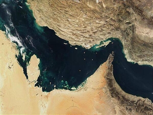
The Persian Gulf (left) and the Gulf of Oman (right) were once the site of a rift, an area where two plates of the earth's crust pulled apart from each other. The Indian Ocean filled in the widening gap between the two plates. Over time, the process reversed, and about 20 million years ago, the gulfs began to close up. The ongoing collision of the two continental plates resulted in Iran's mountainous terrain (top) and its periodic earthquakes. Several Gulf States are visible across the eastern Arabian Peninsula that makes up the lower part of the image. In addition to Saudi Arabia across the bottom, the islands of Bahrain in the left center lie next to the prominent peninsula that makes up Qatar. Further to the right are various offshore islands of the United Arab Emirates; most of the darker area to the right makes up Oman. Photo courtesy of NASA.
The Persian Gulf (left) and the Gulf of Oman (right) were once the site of a rift, an area where two plates of the earth's crust pulled apart from each other. The Indian Ocean filled in the widening gap between the two plates. Over time, the process reversed, and about 20 million years ago, the gulfs began to close up. The ongoing collision of the two continental plates resulted in Iran's mountainous terrain (top) and its periodic earthquakes.
Several Gulf States are visible across the eastern Arabian Peninsula that makes up the lower part of the image. In addition to Saudi Arabia across the bottom, the islands of Bahrain in the left center lie next to the prominent peninsula that makes up Qatar. Further to the right are various offshore islands of the United Arab Emirates; most of the darker area to the right makes up Oman. Photo courtesy of NASA. • CIA World Factbook • 2020
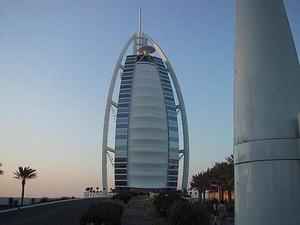
View along the causeway leading to the Burj-al-Arab Hotel in Dubai - at 321 m (1,053 ft), it is one of the world's tallest hotels.
View along the causeway leading to the Burj-al-Arab Hotel in Dubai - at 321 m (1,053 ft), it is one of the world's tallest hotels. • CIA World Factbook • 2020
CIA World Factbook • 2020
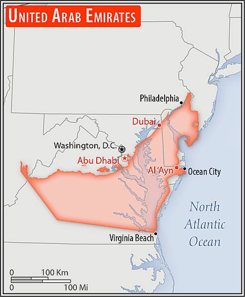
Area comparison map
Area comparison map • CIA World Factbook • 2020
CIA World Factbook • 2020

CIA World Factbook • 2020
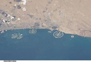
Three man-made archipelagos near Dubai, United Arab Emirates, are featured in this image from the International Space Station (ISS), flying at 350 km (220 mi) above Earth. The municipality of Dubai is the largest city of the Persian Gulf emirate of the same name, and has built a global reputation for large-scale developments and architectural works. Among the most visible of these developments - particularly from the perspective of astronauts onboard the ISS - are three man-made archipelagos. The two Palm Islands - Palm Jumeirah to the left of center, and Palm Jebel Ali, just to the right of center, appear as stylized palm trees when viewed from above. The World Islands (near left edge) evoke a rough map of the world from an air- or space-borne perspective. Image courtesy of NASA.
Three man-made archipelagos near Dubai, United Arab Emirates, are featured in this image from the International Space Station (ISS), flying at 350 km (220 mi) above Earth. The municipality of Dubai is the largest city of the Persian Gulf emirate of the same name, and has built a global reputation for large-scale developments and architectural works. Among the most visible of these developments - particularly from the perspective of astronauts onboard the ISS - are three man-made archipelagos. The two Palm Islands - Palm Jumeirah to the left of center, and Palm Jebel Ali, just to the right of center, appear as stylized palm trees when viewed from above. The World Islands (near left edge) evoke a rough map of the world from an air- or space-borne perspective. Image courtesy of NASA. • CIA World Factbook • 2020
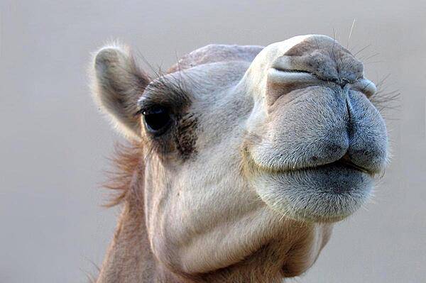
Abu Dhabi camel.
Abu Dhabi camel. • CIA World Factbook • 2020

CIA World Factbook • 2020
Media source: CIA World Factbook (2020) — Public Domain