›››
Afghanistan
Afghanistan
Population
42.6M
Rank #36Source: World Bank
Capital
Kabul
Source: REST Countries
Region
Africa
Middle East, North Africa, Afghanistan & Pakistan
Source: REST Countries
GDP (Nominal)
$17.15B
Source: World Bank
Land Area
652.2K km²
Rank #41Source: REST Countries
Life Expectancy
66.035 yrs
Source: World Bank
Historical Trends
Population Trend (5-Year)
Source: World Bank
GDP Trend (5-Year, Nominal USD)
Source: World Bank
Geography
Area: 652,230 km²
Landlocked: Yes
Independent: Yes
Climate: arid to semiarid; cold winters and hot summers
Terrain: mostly rugged mountains; plains in north and southwest
Elevation: mean elevation: 1,884 m lowest point: Amu Darya 258 m highest point: Noshak 7,492 m
Natural Hazards: damaging earthquakes occur in Hindu Kush mountains; flooding; droughts
Environmental Issues: limited natural freshwater resources; inadequate supplies of potable water; soil degradation; overgrazing; deforestation (much of the remaining forests are being cut down for fuel and building...
Land Use: agricultural land: 58.1% (2016 est.) forest: 2.07% (2016 est.) other: 39% (2016)
Geography Note: landlocked; the Hindu Kush mountains that run northeast to southwest divide the northern provinces from the rest of the country; the highest peaks are in the northern Vakhan (Wakhan Corridor)
Natural Resources
natural gaspetroleumcoalcopperchromitetalcbaritessulfurleadzinc
People & Society
Fertility Rate
4.84
Population
42.6M
Religions
Muslim 99.7% (Sunni 84.7 - (89.7%)Shia 10 - (15%)other (0.3%)
Economy
GDP per Capita
$413.758
GDP per Capita PPP
2,201.723
(2023)
(2023)
GNI per Capita
370
(2023)
(2023)
Gini Index
Not Available
Unemployment
13.687%
(2024)
(2024)
Inflation
13.712%
(2022)
(2022)
Public Debt
Not Available
Energy
Electricity Access
85.3%
(2023)
(2023)
Renewable Energy
20%
(2022)
(2022)
CO₂ Emissions
12.068 Mt
(2024)
(2024)
Energy Intensity
2.94 MJ/$
(2021)
(2021)
Renewable Electricity
78.234%
(2021)
(2021)
Environment
Forest Coverage
1.853% of land
(2023)
(2023)
Communications
Internet Users
17.709%
(2023)
(2023)
Mobile Penetration
55.548%
(2023)
(2023)
Broadband Subscribers
0.08%
(2023)
(2023)
Transportation
Air Transport Freight
0.794 M ton-km
(2023)
(2023)
Container Port Traffic
Not Available
Airports
6,427
Rail Lines
N/A
Roads Total
44,747 km(©IRF)
Military
Military Forces
Afghan National Defense and Security Forces (ANDSF) are comprised of military, police, and other security elements:Ministry of Defense: Afghan National Army ((ANA), Afghan Air Force, Afghan Army...
Personnel Strength
Afghan National Defense and Security Forces (ANDSF) have approximately 290,000 active personnel; Ministry of Defense: 185,000; Ministry of Interior: 105,000 note: the authorized strength of the...
Military Expenditure (USD)
$0.28B
Military Expenditure (% of GDP)
1.83%
Military Expenditure History
1.2% of GDP (2019) 1% of GDP (2018) 0.9% of GDP (2017) 1% of GDP (2016) 1% of GDP (2015)
Equipment & Inventories
the Afghan Army and Air Force inventory is mostly a mix of Soviet-era and more modern US equipment; since 2010, the US is the leading supplier of arms to Afghanistan, followed by Russia (2020)
Service Age & Obligation
18 is the legal minimum age for voluntary military service; no conscription
Education
Pre-Primary Enrollment
1.06%
(2011)
(2011)
Primary Enrollment
109.075%
(2019)
(2019)
Secondary Enrollment
57.358%
(2018)
(2018)
Tertiary Enrollment
10.854%
(2020)
(2020)
Education Spending
4.343% of GDP
(2017)
(2017)
Adult Literacy Rate
37.27%
(2021)
(2021)
Pupil-Teacher Ratio
48.79:1
(2018)
(2018)
Health
Physicians per 1,000
0.317
(2023)
(2023)
Safe Water Access
80.832%
(2024)
(2024)
Safe Drinking Water
30.555%
(2024)
(2024)
Under-5 Mortality
55.5 per 1,000
(2023)
(2023)
Maternal Mortality (World Bank)
13.621 per 100,000
(2021)
(2021)
Hospital Beds per 1,000
57.404
(2021)
(2021)
UHC Coverage Index
42
(2023)
(2023)
Measles Immunization
59%
(2024)
(2024)
Social Indicators
Extreme Poverty Rate
Not Available
Food Insecurity
28.1%
(2023)
(2023)
Youth NEET Rate
8.784%
(2021)
(2021)
Governance
Women in Government
Not Available
Voice & Accountability
-1.85
(Weak)
(2023)
(Weak)
(2023)
Political Stability
-2.48
(Weak)
(2023)
(Weak)
(2023)
Government Effectiveness
-1.99
(Weak)
(2023)
(Weak)
(2023)
Regulatory Quality
-1.27
(Weak)
(2023)
(Weak)
(2023)
Rule of Law
-1.65
(Weak)
(2023)
(Weak)
(2023)
Control of Corruption
-1.16
(Weak)
(2023)
(Weak)
(2023)
Government
Government Type
presidential Islamic republic
Legal System
mixed legal system of civil, customary, and Islamic (sharia) law
Executive Branch
chief of state: President of the Islamic Republic of Afghanistan Ashraf GHANI (since 29 September 2014); CEO Abdullah ABDULLAH, Dr. (since 29 September 2014); First Vice President Abdul Rashid DOSTAM...
Legislative Branch
description: bicameral National Assembly consists of:Meshrano Jirga or House of Elders (102 seats; 34 members indirectly elected by absolute majority vote in 2 rounds if needed by district councils...
Judicial Branch
highest courts: Supreme Court or Stera Mahkama (consists of the supreme court chief and 8 justices organized into criminal, public security, civil, and commercial divisions or dewans) judge selection...
National Symbols
Flag Description
three equal vertical bands of black (hoist side), red, and green, with the national emblem in white centered on the red band and slightly overlapping the other 2 bands; the center of the emblem...
National Symbols
lion; national colors: red, green, black
National Anthem
name: "Milli Surood" (National Anthem) lyrics/music: Abdul Bari JAHANI/Babrak WASA note: adopted 2006; the 2004 constitution of the post-Taliban government mandated that a new national anthem should...
Safety
Homicide Rate
4.032 per 100,000
(2021)
(2021)
Travel Information
Language(s): Dari, Pashto, Turkmen
Currency: AFN (؋)
Timezone(s): UTC+04:30
Landlocked: Yes
Independent: Yes
Driving Side: Right
Calling Code: +93
Car Sign: AFG
Week Starts: Monday
Photos
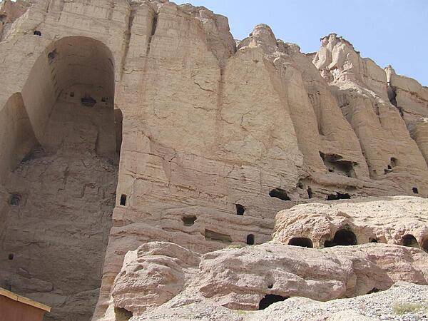
View of the shell of the "Large Buddha" and surrounding caves in Bamyan. The Buddha statue in this cave as well as in another - both dating to the sixth century A.D. - were frequently visited and described over the centuries by travelers on the Silk Road. Both statues were destroyed by the Taliban in 2001.
View of the shell of the "Large Buddha" and surrounding caves in Bamyan. The Buddha statue in this cave as well as in another - both dating to the sixth century A.D. - were frequently visited and described over the centuries by travelers on the Silk Road. Both statues were destroyed by the Taliban in 2001. • CIA World Factbook • 2020
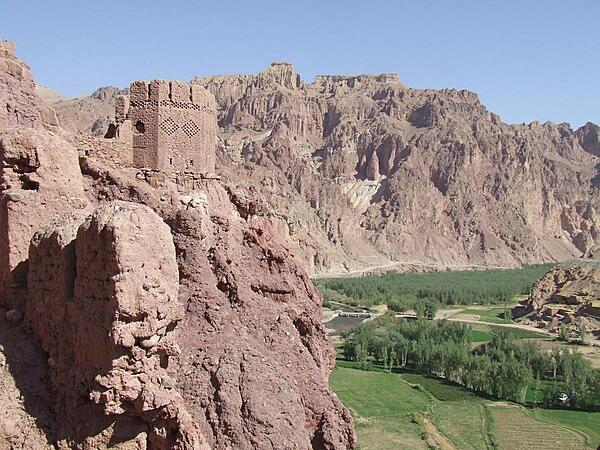
View from Shahr-i-Zohok (the "Red City") in Bamyan Province. Once a citadel housing about 3,000 people, it was destroyed by the Mongols in the 13th century. The invaders also leveled the nearby city that the fortress had protected and massacred all its inhabitants (possibly 150,000) and animals. In memory, the site is today known as Shahr-i-Gholghola (the "City of Screams").
View from Shahr-i-Zohok (the "Red City") in Bamyan Province. Once a citadel housing about 3,000 people, it was destroyed by the Mongols in the 13th century. The invaders also leveled the nearby city that the fortress had protected and massacred all its inhabitants (possibly 150,000) and animals. In memory, the site is today known as Shahr-i-Gholghola (the "City of Screams"). • CIA World Factbook • 2020
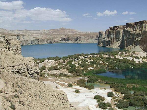
Band-e-Amir in Bamyan Province is Afghanistan's first national park; it consists of six spectacular turquoise lakes separated by natural dams of travertine.
Band-e-Amir in Bamyan Province is Afghanistan's first national park; it consists of six spectacular turquoise lakes separated by natural dams of travertine. • CIA World Factbook • 2020
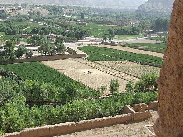
View of surrounding farmlands from within the caves at the "Large Buddha" in Bamyan.
View of surrounding farmlands from within the caves at the "Large Buddha" in Bamyan. • CIA World Factbook • 2020
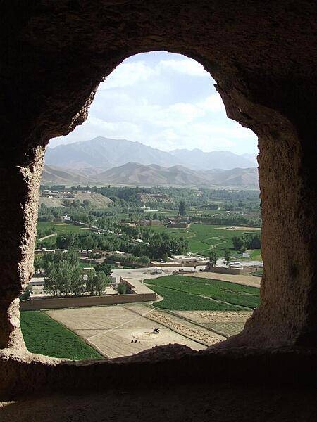
View of surrounding farmlands from within the caves at the "Large Buddha" in Bamyan. The caves were once inhabited by Buddhist monks who left behind a legacy of religious frescoes and paintings, partially destroyed by the fundamentalist Taliban.
View of surrounding farmlands from within the caves at the "Large Buddha" in Bamyan. The caves were once inhabited by Buddhist monks who left behind a legacy of religious frescoes and paintings, partially destroyed by the fundamentalist Taliban. • CIA World Factbook • 2020
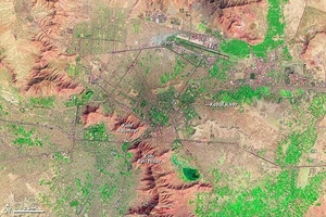
For more than 3,000 years, Kabul has occupied a strategic location along Central and Southern Asian trade routes. In the late eighteenth century, Kabul was established as Afghanistan's capital. In this false-color satellite image vegetation appears fluorescent green, urban areas range in color from gray to black, and bare ground varies in color from beige to reddish brown. A mountain range, including Kohi Asamayi and Kohi Bini Hisar, snakes through the scene, running roughly northwest-southeast. More peaks appear in the northeast, right next to an airport. Urbanization appears densest at the city's center, just southwest of the airport, and it stretches out toward the right side of the image along an east-west highway. Leaping a mountain boundary, cityscape also fills the lower-left quadrant of the image. Partly constrained by surrounding mountains, Kabul's primary direction for growth has been vertical, with multistory buildings constructed atop existing structures. Photo courtesy of NASA.
For more than 3,000 years, Kabul has occupied a strategic location along Central and Southern Asian trade routes. In the late eighteenth century, Kabul was established as Afghanistan's capital.
In this false-color satellite image vegetation appears fluorescent green, urban areas range in color from gray to black, and bare ground varies in color from beige to reddish brown. A mountain range, including Kohi Asamayi and Kohi Bini Hisar, snakes through the scene, running roughly northwest-southeast. More peaks appear in the northeast, right next to an airport. Urbanization appears densest at the city's center, just southwest of the airport, and it stretches out toward the right side of the image along an east-west highway. Leaping a mountain boundary, cityscape also fills the lower-left quadrant of the image.
Partly constrained by surrounding mountains, Kabul's primary direction for growth has been vertical, with multistory buildings constructed atop existing structures. Photo courtesy of NASA. • CIA World Factbook • 2020
16 photos available
View All Photos→Data sources: World Bank, UN Data • Updated daily •Learn about our data