›››
Angola
Angola
Population
37.9M
Rank #40Source: World Bank
Capital
Luanda
Source: REST Countries
Region
Africa
Sub-Saharan Africa
Source: REST Countries
GDP (Nominal)
$101.00B
Rank #71Source: World Bank
Land Area
1.2M km²
Rank #23Source: REST Countries
Life Expectancy
64.617 yrs
Source: World Bank
Historical Trends
Population Trend (5-Year)
Source: World Bank
GDP Trend (5-Year, Nominal USD)
Source: World Bank
Geography
Area: 1,246,700 km²
Landlocked: No
Independent: Yes
Climate: semiarid in south and along coast to Luanda; north has cool, dry season (May to October) and hot, rainy season (November to April)
Terrain: narrow coastal plain rises abruptly to vast interior plateau
Elevation: mean elevation: 1,112 m lowest point: Atlantic Ocean 0 m highest point: Moca 2,620 m
Natural Hazards: locally heavy rainfall causes periodic flooding on the plateau
Environmental Issues: overuse of pastures and subsequent soil erosion attributable to population pressures; desertification; deforestation of tropical rain forest, in response to both international demand for tropical...
Land Use: agricultural land: 47.5% (2016 est.) forest: 46.3% (2016 est.) other: 6.2% (2016 est.)
Geography Note: the province of Cabinda is an exclave, separated from the rest of the country by the Democratic Republic of the Congo
Natural Resources
petroleumdiamondsiron orephosphatescopperfeldspargoldbauxiteuranium
People & Society
Fertility Rate
5.12
Population
37.9M
Ethnic Groups
Ovimbundu (37%)Kimbundu (25%)Bakongo (13%)mestico (mixed European and native African) (2%)European (1%)other (22%)
Religions
Roman Catholic (41.1%)Protestant (38.1%)other (8.6%)none (12.3%)
Economy
GDP per Capita
$2,665.874
GDP per Capita PPP
10,118.609
(2024)
(2024)
GNI per Capita
2,840
(2024)
(2024)
Gini Index
51.3
(2018)
(2018)
Unemployment
14.02%
(2024)
(2024)
Inflation
28.24%
(2024)
(2024)
Public Debt
Not Available
Energy
Electricity Access
51.1%
(2023)
(2023)
Renewable Energy
52.9%
(2021)
(2021)
CO₂ Emissions
28.1 Mt
(2024)
(2024)
Energy Intensity
3.1 MJ/$
(2021)
(2021)
Renewable Electricity
91.714%
(2021)
(2021)
Environment
Forest Coverage
52.091% of land
(2023)
(2023)
Communications
Internet Users
44.758%
(2023)
(2023)
Mobile Penetration
70.052%
(2023)
(2023)
Broadband Subscribers
0.374%
(2023)
(2023)
Transportation
Air Transport Freight
70.708 M ton-km
(2023)
(2023)
Container Port Traffic
654,590 TEU
(2022)
(2022)
Airports
14,831
Rail Lines
N/A
Roads Total
76,000 km(©IRF)
Military
Military Forces
Angolan Armed Forces (Forcas Armadas Angolanas, FAA): Army, Navy (Marinha de Guerra Angola, MGA), Angolan National Air Force (Forca Aerea Nacional Angolana, FANA; under operational control of the...
Personnel Strength
the Angolan Armed Forces (FAA) are comprised of approximately 107,000 active troops (100,000 Army; 1,000 Navy; 6,000 Air Force); est. 10,000 Rapid Reaction Police
Military Expenditure (USD)
$0.92B
Military Expenditure (% of GDP)
1.00%
Military Expenditure History
1.6% of GDP (2019) 1.8% of GDP (2018) 2.4% of GDP (2017) 3% of GDP (2016) 3.5% of GDP (2015)
Equipment & Inventories
most Angolan Armed Forces weapons and equipment are of Russian, Soviet, or Warsaw Pact origin; Russia remains Angola's top supplier of military hardware, followed by Belarus and China (2019)
Service Age & Obligation
20-45 years of age for compulsory male and 18-45 years for voluntary male military service (registration at age 18 is mandatory); 20-45 years of age for voluntary female service; 2-year conscript...
Education
Pre-Primary Enrollment
39.611%
(2016)
(2016)
Primary Enrollment
86.735%
(2023)
(2023)
Secondary Enrollment
51.484%
(2023)
(2023)
Tertiary Enrollment
9.955%
(2024)
(2024)
Education Spending
2.513% of GDP
(2023)
(2023)
Adult Literacy Rate
66.24%
(2015)
(2015)
Pupil-Teacher Ratio
50.03:1
(2015)
(2015)
Health
Physicians per 1,000
0.244
(2022)
(2022)
Safe Water Access
67.961%
(2024)
(2024)
Safe Drinking Water
Not Available
Under-5 Mortality
64 per 1,000
(2023)
(2023)
Maternal Mortality (World Bank)
15.846 per 100,000
(2021)
(2021)
Hospital Beds per 1,000
60.007
(2021)
(2021)
UHC Coverage Index
44
(2023)
(2023)
Measles Immunization
64%
(2024)
(2024)
Social Indicators
Extreme Poverty Rate
39.3%
(2018)
(2018)
Food Insecurity
22.5%
(2023)
(2023)
Youth NEET Rate
26.585%
(2022)
(2022)
Governance
Women in Government
39.545%
(2024)
(2024)
Voice & Accountability
-0.74
(Below Average)
(2023)
(Below Average)
(2023)
Political Stability
-0.34
(Below Average)
(2023)
(Below Average)
(2023)
Government Effectiveness
-1.01
(Weak)
(2023)
(Weak)
(2023)
Regulatory Quality
-0.76
(Below Average)
(2023)
(Below Average)
(2023)
Rule of Law
-1.10
(Weak)
(2023)
(Weak)
(2023)
Control of Corruption
-0.61
(Below Average)
(2023)
(Below Average)
(2023)
Government
Government Type
presidential republic
Legal System
civil legal system based on Portuguese civil law; no judicial review of legislation
Executive Branch
chief of state: President Joao Manuel Goncalves LOURENCO (since 26 September 2017); Vice President Bornito De Sousa Baltazar DIOGO (since 26 September 2017); note - the president is both chief of...
Legislative Branch
description: unicameral National Assembly or Assembleia Nacional (220 seats; members directly elected in a single national constituency and in multi-seat constituencies by closed list proportional...
Judicial Branch
highest courts: Supreme Court or Supremo Tribunal de Justica (consists of the court president, vice president, and a minimum of 16 judges); Constitutional Court or Tribunal Constitucional (consists...
National Symbols
Flag Description
two equal horizontal bands of red (top) and black with a centered yellow emblem consisting of a five-pointed star within half a cogwheel crossed by a machete (in the style of a hammer and sickle);...
National Symbols
Palanca Negra Gigante (giant black sable antelope); national colors: red, black, yellow
National Anthem
name: "Angola Avante" (Forward Angola) lyrics/music: Manuel Rui Alves MONTEIRO/Rui Alberto Vieira Dias MINGAO note: adopted 1975
Safety
Homicide Rate
4.098 per 100,000
(2016)
(2016)
Travel Information
Language(s): Portuguese
Currency: AOA (Kz)
Timezone(s): UTC+01:00
Landlocked: No
Independent: Yes
Driving Side: Right
Calling Code: +244
Car Sign: ANG
Week Starts: Monday
Photos
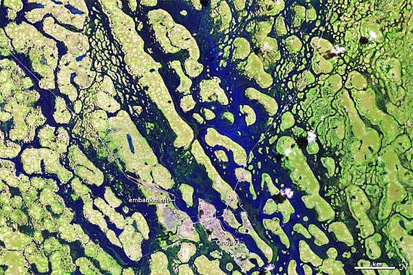
Seasonal floods affected thousands of people in Angola and Namibia during a rainy season that stretched through April 2011. Flood waters finally receded in May, but not before an estimated 260,000 residents had been affected. Around the city of Ondjiva, in southern Angola, water levels dropped significantly between late March and mid-May. The satellite captured this "after" image of the area on 13 May 2011. Made from a combination of shortwave infrared, near infrared, and red light, these images distinguish between water and land better than natural-color images. Vegetation appears bright green, and water appears bright blue. Thin white lines show embankments, which afforded Ondjiva some protection from the high waters in early 2011. Rainy season in this region can last from November to April. Image courtesy of NASA.
Seasonal floods affected thousands of people in Angola and Namibia during a rainy season that stretched through April 2011. Flood waters finally receded in May, but not before an estimated 260,000 residents had been affected. Around the city of Ondjiva, in southern Angola, water levels dropped significantly between late March and mid-May. The satellite captured this "after" image of the area on 13 May 2011. Made from a combination of shortwave infrared, near infrared, and red light, these images distinguish between water and land better than natural-color images. Vegetation appears bright green, and water appears bright blue. Thin white lines show embankments, which afforded Ondjiva some protection from the high waters in early 2011. Rainy season in this region can last from November to April. Image courtesy of NASA. • CIA World Factbook • 2020
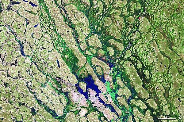
Seasonal floods affected thousands of people in Angola and Namibia during a rainy season that stretched through April 2011. Flood waters finally receded in May, but not before an estimated 260,000 residents had been affected. Around the city of Ondjiva, in southern Angola, water levels dropped significantly between late March (this photo) and mid-May (next photo). The satellite captured this "before" image of the area on 30 March 2011. Made from a combination of shortwave infrared, near infrared, and red light, these images distinguish between water and land better than natural-color images. Vegetation appears bright green, and water appears bright blue. Thin white lines show embankments, which afforded Ondjiva some protection from the high waters in early 2011. Rainy season in this region can last from November to April. Image courtesy of NASA.
Seasonal floods affected thousands of people in Angola and Namibia during a rainy season that stretched through April 2011. Flood waters finally receded in May, but not before an estimated 260,000 residents had been affected. Around the city of Ondjiva, in southern Angola, water levels dropped significantly between late March (this photo) and mid-May (next photo). The satellite captured this "before" image of the area on 30 March 2011. Made from a combination of shortwave infrared, near infrared, and red light, these images distinguish between water and land better than natural-color images. Vegetation appears bright green, and water appears bright blue. Thin white lines show embankments, which afforded Ondjiva some protection from the high waters in early 2011. Rainy season in this region can last from November to April. Image courtesy of NASA. • CIA World Factbook • 2020
Area comparison map
Area comparison map • CIA World Factbook • 2020
3 photos available
Data sources: World Bank, UN Data • Updated daily •Learn about our data