›››
American Samoa
American Samoa
Population
46.8K
Rank #204Source: World Bank
Capital
Pago Pago
Source: REST Countries
Region
Asia
East Asia & Pacific
Source: REST Countries
GDP (Nominal)
$871.00M
Source: World Bank
Land Area
199 km²
Rank #203Source: REST Countries
Life Expectancy
72.852 yrs
Source: World Bank
Historical Trends
Population Trend (5-Year)
Source: World Bank
GDP Trend (5-Year, Nominal USD)
Source: World Bank
Geography
Area: 199 km²
Landlocked: No
Independent: No
Climate: tropical marine, moderated by southeast trade winds; annual rainfall averages about 3 m; rainy season (November to April), dry season (May to October); little seasonal temperature variation
Terrain: five volcanic islands with rugged peaks and limited coastal plains, two coral atolls (Rose Island, Swains Island)
Elevation: lowest point: Pacific Ocean 0 m highest point: Lata Mountain 964 m
Natural Hazards: cyclones common from December to Marchvolcanism: limited volcanic activity on the Ofu and Olosega Islands; neither has erupted since the 19th century
Environmental Issues: limited supply of drinking water; pollution; waste disposal; coastal and stream alteration; soil erosion
Land Use: agricultural land: 21.9% (2016 est.) forest: 78.1% (2016 est.) other: 0% (2016 est.)
Geography Note: Pago Pago has one of the best natural deepwater harbors in the South Pacific Ocean, sheltered by shape from rough seas and protected by peripheral mountains from high winds; strategic location in the...
Natural Resources
pumicepumicite
People & Society
Fertility Rate
2.29
Population
46.8K
Ethnic Groups
Pacific Islander 92.6% (includes Samoan (88.9%)Tongan (2.9%)other (0.8%)Asian 3.6% (includes Filipino (2.2%)other (1.4%)mixed (2.7%)other (1.2%)
Religions
Christian (98.3%)other (1%)unaffiliated (0.7%)
Energy
Electricity Access
Not Available
Renewable Energy
0.4%
(2022)
(2022)
CO₂ Emissions
Not Available
Energy Intensity
Not Available
Renewable Electricity
3.873%
(2021)
(2021)
Environment
Forest Coverage
85.2% of land
(2023)
(2023)
Transportation
Air Transport Freight
0.012 M ton-km
(2014)
(2014)
Container Port Traffic
76,200 TEU
(2019)
(2019)
Airports
9,144
Rail Lines
N/A
Roads Total
N/A
Health
Physicians per 1,000
Not Available
Safe Water Access
100%
(2024)
(2024)
Safe Drinking Water
90.538%
(2024)
(2024)
Under-5 Mortality
Not Available
Maternal Mortality (World Bank)
Not Available
Governance
Women in Government
Not Available
Voice & Accountability
Not Available
Political Stability
1.11
(Strong)
(2023)
(Strong)
(2023)
Government Effectiveness
0.65
(Above Average)
(2023)
(Above Average)
(2023)
Regulatory Quality
0.51
(Above Average)
(2023)
(Above Average)
(2023)
Rule of Law
1.21
(Strong)
(2023)
(Strong)
(2023)
Control of Corruption
1.25
(Strong)
(2023)
(Strong)
(2023)
Government
Government Type
republican form of government with separate executive, legislative, and judicial branches; unincorporated unorganized territory of the US with local self-government
Legal System
mixed legal system of US common law and customary law
Executive Branch
chief of state: President Donald J. TRUMP (since 20 January 2017); Vice President Michael R. PENCE (since 20 January 2017) head of government: Governor Lolo Matalasi MOLIGA (since 3 January...
Legislative Branch
description: bicameral Legislature or Fono consists of:Senate (18 seats; members indirectly selected by regional governing councils to serve 4-year terms)House of Representatives (21 seats; 20...
Judicial Branch
highest courts: High Court of American Samoa (consists of the chief justice, associate chief justice, and 6 Samoan associate judges and organized into trial, family, drug, and appellate divisions);...
International Organizations
National Symbols
Flag Description
blue, with a white triangle edged in red that is based on the fly side and extends to the hoist side; a brown and white American bald eagle flying toward the hoist side is carrying 2 traditional...
National Symbols
a fue (coconut fiber fly whisk; representing wisdom) crossed with a to'oto'o (staff; representing authority); national colors: red, white, blue
National Anthem
name: "Amerika Samoa" (American Samoa) lyrics/music: Mariota Tiumalu TUIASOSOPO/Napoleon Andrew TUITELELEAPAGA note: local anthem adopted 1950; as a territory of the United States, "The Star-Spangled...
Safety
Homicide Rate
25.536 per 100,000
(2018)
(2018)
Travel Information
Language(s): English, Samoan
Currency: USD ($)
Timezone(s): UTC-11:00
Landlocked: No
Independent: No
Driving Side: Right
Calling Code: +1
Car Sign: USA
Week Starts: Monday
Photos
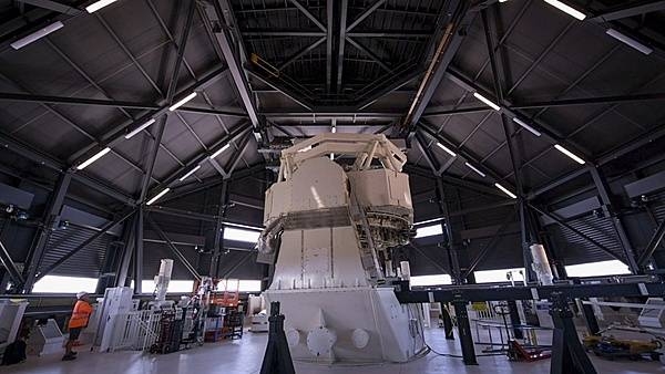
The Space Surveillance Telescope (SST), located near Exmouth, in Western Australia is operated by the US Air Force in conjunction with the Royal Australian Air Force. The SST is a ground-based optical system that detects and tracks small objects in deep space, and provides an unprecedented wide-area search capability that will enhance space situational awareness of the Southern Celestial Hemisphere. Minimal light pollution will allow the telescope to provide a clearer picture that lends to its wide field of view. With an estimated time of full operational capability in 2021, it will also be able to detect, track, and discern small, obscure objects in deep space. Photo courtesy of the US Navy/ Mass Communication Specialist 2nd Class Jeanette Mullinax.
The Space Surveillance Telescope (SST), located near Exmouth, in Western Australia is operated by the US Air Force in conjunction with the Royal Australian Air Force. The SST is a ground-based optical system that detects and tracks small objects in deep space, and provides an unprecedented wide-area search capability that will enhance space situational awareness of the Southern Celestial Hemisphere. Minimal light pollution will allow the telescope to provide a clearer picture that lends to its wide field of view. With an estimated time of full operational capability in 2021, it will also be able to detect, track, and discern small, obscure objects in deep space. Photo courtesy of the US Navy/ Mass Communication Specialist 2nd Class Jeanette Mullinax. • CIA World Factbook • 2020
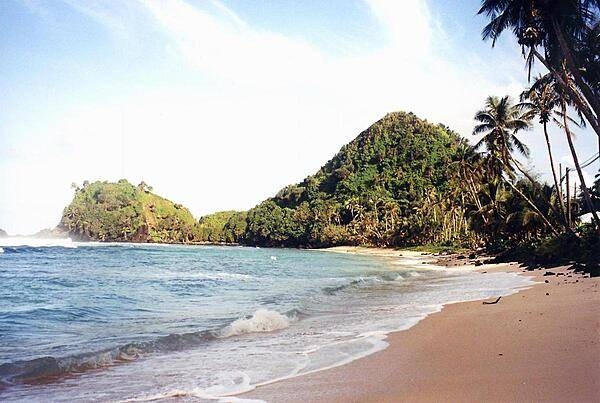
Deserted beach near Pago Pago. American Samoa is an incorporated, self-governing territory of the US. A part of the Samoan island chain, it is the southernmost territory of the US. The large harbor at Pago Pago contains a full US naval station. The inhabitants of American Samoa are American nationals, but not necessarily American citizens.
Deserted beach near Pago Pago. American Samoa is an incorporated, self-governing territory of the US. A part of the Samoan island chain, it is the southernmost territory of the US. The large harbor at Pago Pago contains a full US naval station. The inhabitants of American Samoa are American nationals, but not necessarily American citizens. • CIA World Factbook • 2020
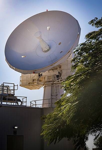
The US Air Force and the Royal Australian Air Force are working together near Exmouth, in Western Australia, to advance the combined Space Surveillance Network with a C-Band space surveillance radar system and a space surveillance telescope. A C-Band space surveillance radar system, owned by the US Air Force, operates as a dedicated sensor node strategically located to cover both the southern and eastern hemisphere. The C-Band radar provides tracking and identification of space assets and debris for the US space surveillance network. Photo courtesy of the US Navy/ Mass Communication Specialist 2nd Class Jeanette Mullinax.
The US Air Force and the Royal Australian Air Force are working together near Exmouth, in Western Australia, to advance the combined Space Surveillance Network with a C-Band space surveillance radar system and a space surveillance telescope. A C-Band space surveillance radar system, owned by the US Air Force, operates as a dedicated sensor node strategically located to cover both the southern and eastern hemisphere. The C-Band radar provides tracking and identification of space assets and debris for the US space surveillance network. Photo courtesy of the US Navy/ Mass Communication Specialist 2nd Class Jeanette Mullinax. • CIA World Factbook • 2020
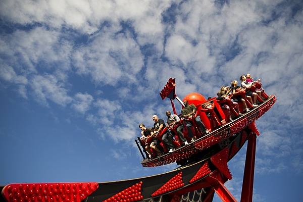
Visiting US Sailors join the crowd riding the Redback at Aussie World, a theme park located on the Sunshine Coast in Queensland, Australia. Photo courtesy of the US Navy/ Mass Communication Specialist 3rd Class Jessica Gomez.
Visiting US Sailors join the crowd riding the Redback at Aussie World, a theme park located on the Sunshine Coast in Queensland, Australia. Photo courtesy of the US Navy/ Mass Communication Specialist 3rd Class Jessica Gomez. • CIA World Factbook • 2020
4 photos available
Data sources: World Bank, UN Data • Updated daily •Learn about our data