›››
Azerbaijan
Azerbaijan
Population
10.2M
Rank #94Source: World Bank
Capital
Baku
Source: REST Countries
Region
Europe
Europe & Central Asia
Source: REST Countries
GDP (Nominal)
$74.32B
Rank #84Source: World Bank
Land Area
86.6K km²
Rank #112Source: REST Countries
Life Expectancy
74.429 yrs
Source: World Bank
Historical Trends
Population Trend (5-Year)
Source: World Bank
GDP Trend (5-Year, Nominal USD)
Source: World Bank
Geography
Area: 86,600 km²
Landlocked: Yes
Independent: Yes
Climate: dry, semiarid steppe
Terrain: large, flat Kur-Araz Ovaligi (Kura-Araks Lowland, much of it below sea level) with Great Caucasus Mountains to the north, Qarabag Yaylasi (Karabakh Upland) to the west; Baku lies on Abseron Yasaqligi...
Elevation: mean elevation: 384 m lowest point: Caspian Sea -28 m highest point: Bazarduzu Dagi 4,466 m
Natural Hazards: droughts
Environmental Issues: local scientists consider the Abseron Yasaqligi (Apsheron Peninsula) (including Baku and Sumqayit) and the Caspian Sea to be the ecologically most devastated area in the world because of severe air,...
Land Use: agricultural land: 57.6% (2016 est.) forest: 11.3% (2016 est.) other: 31.1% (2016 est.)
Geography Note: both the main area of the country and the Naxcivan exclave are landlocked
Natural Resources
petroleumnatural gasiron orenonferrous metalsbauxite
People & Society
Fertility Rate
1.55
Population
10.2M
Ethnic Groups
Azerbaijani (91.6%)Lezghin (2%)Russian (1.3%)Armenian (1.3%)Talysh (1.3%)other (2.4%)
Religions
Muslim (96.9%)Christian (3%)
Economy
GDP per Capita
$7,283.85
GDP per Capita PPP
25,088.999
(2024)
(2024)
GNI per Capita
7,330
(2024)
(2024)
Gini Index
Not Available
Unemployment
5.648%
(2024)
(2024)
Inflation
2.212%
(2024)
(2024)
Public Debt
Not Available
Energy
Electricity Access
100%
(2023)
(2023)
Renewable Energy
1.3%
(2021)
(2021)
CO₂ Emissions
38.888 Mt
(2024)
(2024)
Energy Intensity
4.4 MJ/$
(2022)
(2022)
Renewable Electricity
5.799%
(2021)
(2021)
Environment
Forest Coverage
14.112% of land
(2023)
(2023)
Protected Areas
10.2% of land
(2011)
(2011)
Communications
Internet Users
89%
(2023)
(2023)
Mobile Penetration
107.687%
(2023)
(2023)
Broadband Subscribers
20.883%
(2023)
(2023)
Transportation
Air Transport Freight
1,434.481 M ton-km
(2023)
(2023)
Container Port Traffic
Not Available
Airports
28,424
Rail Lines
2,138.85 km
Roads Total
78,632 km(©IRF)
Military
Military Forces
Land Forces, Air Forces, Navy Forces; Ministry of Internal Affairs: State Border Service (includes Coast Guard), Internal Security Troops
Personnel Strength
the Azerbaijan military has approximately 67,000 total active personnel; 56,000 Army; 2,500 Navy; 8,500 Air Force)
Military Expenditure (USD)
$3.78B
Military Expenditure (% of GDP)
4.99%
Military Expenditure History
4% of GDP (2019) 3.6% of GDP (2018) 3.8% of GDP (2017) 3.7% of GDP (2016) 5.5% of GDP (2015)
Deployments
120 Afghanistan (NATO) (2020)
Equipment & Inventories
the inventory of the Azerbaijan military includes mostly Russian and Soviet-era equipment; since 2010, Russia is the leading supplier of arms to Azerbaijan, followed by Israel and Turkey (2020)
Service Age & Obligation
18-35 years of age for compulsory military service; service obligation 18 months or 12 months for university graduates; 17 years of age for voluntary service; 17 year olds are considered to be on...
Education
Pre-Primary Enrollment
46.29%
(2021)
(2021)
Primary Enrollment
105.625%
(2024)
(2024)
Secondary Enrollment
91.123%
(2024)
(2024)
Tertiary Enrollment
41.341%
(2024)
(2024)
Education Spending
3.664% of GDP
(2023)
(2023)
Adult Literacy Rate
99.78%
(2023)
(2023)
Pupil-Teacher Ratio
15.43:1
(2018)
(2018)
Health
Physicians per 1,000
3.185
(2022)
(2022)
Safe Water Access
97.688%
(2024)
(2024)
Safe Drinking Water
57.812%
(2024)
(2024)
Under-5 Mortality
18.6 per 1,000
(2023)
(2023)
Maternal Mortality (World Bank)
17.129 per 100,000
(2021)
(2021)
Hospital Beds per 1,000
70.496
(2021)
(2021)
UHC Coverage Index
67
(2023)
(2023)
Measles Immunization
51%
(2024)
(2024)
Social Indicators
Extreme Poverty Rate
Not Available
Food Insecurity
2.5%
(2023)
(2023)
Youth NEET Rate
13.55%
(2022)
(2022)
Governance
Women in Government
20.8%
(2024)
(2024)
Voice & Accountability
-1.41
(Weak)
(2023)
(Weak)
(2023)
Political Stability
-0.73
(Below Average)
(2023)
(Below Average)
(2023)
Government Effectiveness
-0.03
(Below Average)
(2023)
(Below Average)
(2023)
Regulatory Quality
-0.11
(Below Average)
(2023)
(Below Average)
(2023)
Rule of Law
-0.57
(Below Average)
(2023)
(Below Average)
(2023)
Control of Corruption
-1.20
(Weak)
(2023)
(Weak)
(2023)
Government
Government Type
presidential republic
Legal System
civil law system
Executive Branch
chief of state: President Ilham ALIYEV (since 31 October 2003); First Vice President Mehriban ALIYEVA (since 21 February 2017) head of government: Prime Minister Ali ASADOV (since 8 October 2019);...
Legislative Branch
description: unicameral National Assembly or Milli Mejlis (125 seats; members directly elected in single-seat constituencies by simple majority vote to serve 5-year terms) elections: last held on 9...
Judicial Branch
highest courts: Supreme Court (consists of the chairman, vice chairman, and 23 judges in plenum sessions and organized into civil, economic affairs, criminal, and rights violations chambers);...
National Symbols
Flag Description
three equal horizontal bands of sky blue (top), red, and green; a vertical crescent moon and an eight-pointed star in white are centered in the red band; the blue band recalls Azerbaijan's Turkic...
National Symbols
flames of fire; national colors: blue, red, green
National Anthem
name: "Azerbaijan Marsi" (March of Azerbaijan) lyrics/music: Ahmed JAVAD/Uzeyir HAJIBEYOV note: adopted 1992; although originally written in 1919 during a brief period of independence, "Azerbaijan...
Safety
Homicide Rate
2.161 per 100,000
(2023)
(2023)
Travel Information
Language(s): Azerbaijani
Currency: AZN (₼)
Timezone(s): UTC+04:00
Landlocked: Yes
Independent: Yes
Driving Side: Right
Calling Code: +994
Car Sign: AZ
Week Starts: Monday
Photos
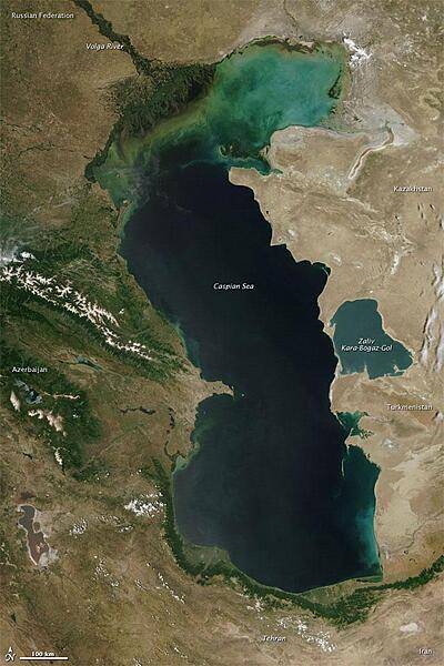
Measured by surface area, the Caspian Sea is the world's largest inland water body. It covers roughly 371,000 sq km (143,200 sq mi) and borders five countries. To the ancient Greeks and Persians, the lake's immense size suggested it was an ocean, hence its name. A large expanse of clear sky permitted this natural-color satellite image of the entire water body. The color of the Caspian Sea darkens from north to south, thanks to changes in depth and perhaps sediment and other runoff. The northern part of the lake is just 5 to 6 m (16 to 20 ft) deep. The southern end, however, plunges more than 1,000 m (3,300 ft). Just as the lake reaches a greater depth in the south, the nearby land reaches a greater height. The mountains of northern Iran line the southern end of the giant lake, and emerald green vegetation clings to those mountain slopes. In marked contrast to the mountains, sand seas line the southeastern and northern perimeters of the lake, and marshes occur along the lake shores in Azerbaijan to the west. Multiple rivers empty into the Caspian Sea, the Volga being the largest. Lacking an outlet, the Caspian Sea loses water only by evaporation, leading to the accumulation of salt. Although a lake, the Caspian is not a freshwater lake; the water delivered by the Volga River minimizes the lake's salt content at the northern end, but the Caspian grows more saline to the south. Kara-Bogaz-Gol is a saline inlet along the lake's eastern perimeter. Image courtesy of NASA.
Measured by surface area, the Caspian Sea is the world's largest inland water body. It covers roughly 371,000 sq km (143,200 sq mi) and borders five countries. To the ancient Greeks and Persians, the lake's immense size suggested it was an ocean, hence its name. A large expanse of clear sky permitted this natural-color satellite image of the entire water body. The color of the Caspian Sea darkens from north to south, thanks to changes in depth and perhaps sediment and other runoff. The northern part of the lake is just 5 to 6 m (16 to 20 ft) deep. The southern end, however, plunges more than 1,000 m (3,300 ft). Just as the lake reaches a greater depth in the south, the nearby land reaches a greater height. The mountains of northern Iran line the southern end of the giant lake, and emerald green vegetation clings to those mountain slopes. In marked contrast to the mountains, sand seas line the southeastern and northern perimeters of the lake, and marshes occur along the lake shores in Azerbaijan to the west. Multiple rivers empty into the Caspian Sea, the Volga being the largest. Lacking an outlet, the Caspian Sea loses water only by evaporation, leading to the accumulation of salt. Although a lake, the Caspian is not a freshwater lake; the water delivered by the Volga River minimizes the lake's salt content at the northern end, but the Caspian grows more saline to the south. Kara-Bogaz-Gol is a saline inlet along the lake's eastern perimeter. Image courtesy of NASA. • CIA World Factbook • 2020
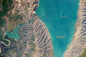
This astronaut photograph highlights the southern Mingachevir Reservoir in north-central Azerbaijan. The Mingachevir Reservoir occupies part of the Kura Basin, a topographic depression located between the Greater Caucasus Mountains to the northeast and the Lesser Caucasus Mountains to the southwest. The afternoon sun highlights distinctive parallel patterns in the hills that are the result of water and wind erosion of different rock layers exposed at the surface. The nearby city of Mingachevir (left) is split by the Kur River after it passes through the dam and hydroelectric power station complex at image top center. The current city was built in support of the hydroelectric power station constructed as part of the then-Soviet Union's energy infrastructure for the region. Today, Mingachevir is the fourth-largest city in Azerbaijan (by population), and it has become a cultural and economic center of the country. The width of the reservoir illustrated here is approximately 8 km (5 mi); a jet flying over the reservoir left a contrail midway between the shorelines. Photo courtesy of NASA.
This astronaut photograph highlights the southern Mingachevir Reservoir in north-central Azerbaijan. The Mingachevir Reservoir occupies part of the Kura Basin, a topographic depression located between the Greater Caucasus Mountains to the northeast and the Lesser Caucasus Mountains to the southwest. The afternoon sun highlights distinctive parallel patterns in the hills that are the result of water and wind erosion of different rock layers exposed at the surface. The nearby city of Mingachevir (left) is split by the Kur River after it passes through the dam and hydroelectric power station complex at image top center. The current city was built in support of the hydroelectric power station constructed as part of the then-Soviet Union's energy infrastructure for the region. Today, Mingachevir is the fourth-largest city in Azerbaijan (by population), and it has become a cultural and economic center of the country. The width of the reservoir illustrated here is approximately 8 km (5 mi); a jet flying over the reservoir left a contrail midway between the shorelines. Photo courtesy of NASA. • CIA World Factbook • 2020
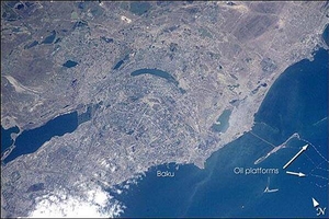
Baku is Azerbaijan's major city, and the oil capital of the Caspian region. This photo shows details of the city, including the extensive port facilities, and part of the large web of offshore oil platforms in the Caspian Sea. The oil platforms off Baku were built in the 1950s and 1960s, and were the first offshore oil-drilling efforts in the world. Today, multinational oil exploration, sea-level rise (the Caspian Sea has risen more than 2 m in the past 20 years), offshore platform maintenance, and environmental degradation are all hot topics in Baku. Image courtesy of NASA.
Baku is Azerbaijan's major city, and the oil capital of the Caspian region. This photo shows details of the city, including the extensive port facilities, and part of the large web of offshore oil platforms in the Caspian Sea. The oil platforms off Baku were built in the 1950s and 1960s, and were the first offshore oil-drilling efforts in the world. Today, multinational oil exploration, sea-level rise (the Caspian Sea has risen more than 2 m in the past 20 years), offshore platform maintenance, and environmental degradation are all hot topics in Baku. Image courtesy of NASA. • CIA World Factbook • 2020
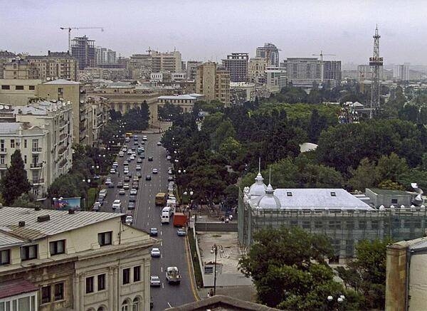
A downtown view of the capital of Baku.
A downtown view of the capital of Baku. • CIA World Factbook • 2020
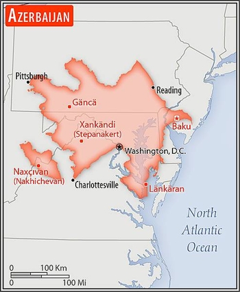
Area comparison map
Area comparison map • CIA World Factbook • 2020
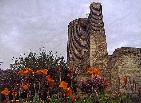
The Maiden Tower, built sometime between A.D. 800 and 1200, is the most recognized structure in the Old City of Baku.
The Maiden Tower, built sometime between A.D. 800 and 1200, is the most recognized structure in the Old City of Baku. • CIA World Factbook • 2020
6 photos available
Data sources: World Bank, UN Data • Updated daily •Learn about our data