›››
Barbados
Barbados
Population
282.5K
Rank #179Source: World Bank
Capital
Bridgetown
Source: REST Countries
Region
Americas
Latin America & Caribbean
Source: REST Countries
GDP (Nominal)
$7.50B
Rank #154Source: World Bank
Land Area
430 km²
Rank #195Source: REST Countries
Life Expectancy
76.178 yrs
Source: World Bank
Historical Trends
Population Trend (5-Year)
Source: World Bank
GDP Trend (5-Year, Nominal USD)
Source: World Bank
Geography
Area: 430 km²
Landlocked: No
Independent: Yes
Climate: tropical; rainy season (June to October)
Terrain: relatively flat; rises gently to central highland region
Elevation: lowest point: Atlantic Ocean 0 m highest point: Mount Hillaby 336 m
Natural Hazards: infrequent hurricanes; periodic landslides
Environmental Issues: pollution of coastal waters from waste disposal by ships; soil erosion; illegal solid waste disposal threatens contamination of aquifers
Land Use: agricultural land: 32.6% (2016 est.) forest: 19.4% (2016 est.) other: 48% (2016 est.)
Geography Note: easternmost Caribbean island
Natural Resources
petroleumfishnatural gas
People & Society
Fertility Rate
1.71
Population
282.5K
Ethnic Groups
African descent (92.4%)mixed (3.1%)White (2.7%)East Indian (1.3%)other (0.2%)unspecified (0.3%)
Religions
Protestant 66.4% (includes Anglican (23.9%)other Pentecostal (19.5%)Adventist (5.9%)Methodist (4.2%)Wesleyan (3.4%)Nazarene (3.2%)Church of God (2.4%)Baptist (1.8%)Moravian (1.2%)other Protestant (0.9%)Roman Catholic (3.8%)other Christian 5.4% (includes Jehovah's Witness (2%)other (3.4%)Rastafarian (1%)other (1.5%)none (20.6%)unspecified (1.2%)
Economy
GDP per Capita
$26,544.871
GDP per Capita PPP
24,822.534
(2024)
(2024)
GNI per Capita
25,140
(2024)
(2024)
Gini Index
34.1
(2016)
(2016)
Unemployment
6.448%
(2024)
(2024)
Inflation
9.792%
(2023)
(2023)
Public Debt
125.131%
(2016)
(2016)
Energy
Electricity Access
100%
(2023)
(2023)
Renewable Energy
5.5%
(2022)
(2022)
CO₂ Emissions
0.713 Mt
(2024)
(2024)
Energy Intensity
3.76 MJ/$
(2022)
(2022)
Renewable Electricity
7.325%
(2021)
(2021)
Environment
Forest Coverage
14.651% of land
(2023)
(2023)
Communications
Internet Users
79.992%
(2023)
(2023)
Mobile Penetration
114.581%
(2022)
(2022)
Broadband Subscribers
37.484%
(2022)
(2022)
Transportation
Air Transport Freight
Not Available
Container Port Traffic
97,000 TEU
(2022)
(2022)
Airports
N/A
Rail Lines
N/A
Roads Total
N/A
Military
Military Forces
Royal Barbados Defense Force: The Barbados Regiment, The Barbados Coast Guard
Personnel Strength
the Royal Barbados Defense Force (RBDF) has approximately 550 active personnel (450 Barbados Regiment; 100 Coast Guard)
Equipment & Inventories
the RBDF's major equipment inventory - maritime patrol boats - is supplied by the Netherlands (2019 est.)
Service Age & Obligation
18 years of age for voluntary military service, or earlier with parental consent; no conscription
Education
Pre-Primary Enrollment
75.127%
(2021)
(2021)
Primary Enrollment
83.937%
(2024)
(2024)
Secondary Enrollment
104.371%
(2024)
(2024)
Tertiary Enrollment
53.582%
(2024)
(2024)
Education Spending
3.556% of GDP
(2024)
(2024)
Pupil-Teacher Ratio
13.992:1
(2018)
(2018)
Health
Physicians per 1,000
2.958
(2022)
(2022)
Safe Water Access
99.163%
(2024)
(2024)
Safe Drinking Water
Not Available
Under-5 Mortality
10 per 1,000
(2023)
(2023)
Maternal Mortality (World Bank)
22.199 per 100,000
(2021)
(2021)
Hospital Beds per 1,000
78.409
(2021)
(2021)
UHC Coverage Index
82
(2023)
(2023)
Measles Immunization
94%
(2024)
(2024)
Social Indicators
Extreme Poverty Rate
1.7%
(2016)
(2016)
Food Insecurity
4.4%
(2023)
(2023)
Youth NEET Rate
18.715%
(2023)
(2023)
Governance
Women in Government
26.667%
(2024)
(2024)
Voice & Accountability
1.16
(Strong)
(2023)
(Strong)
(2023)
Political Stability
1.19
(Strong)
(2023)
(Strong)
(2023)
Government Effectiveness
0.38
(Above Average)
(2023)
(Above Average)
(2023)
Regulatory Quality
0.50
(Above Average)
(2023)
(Above Average)
(2023)
Rule of Law
0.41
(Above Average)
(2023)
(Above Average)
(2023)
Control of Corruption
1.34
(Strong)
(2023)
(Strong)
(2023)
Government
Government Type
parliamentary democracy under a constitutional monarchy; a Commonwealth realm
Legal System
English common law; no judicial review of legislative acts
Executive Branch
chief of state: Queen ELIZABETH II (since 6 February 1952); represented by Governor General Sandra MASON (since 8 January 2018) head of government: Prime Minister Mia MOTTLEY (since 25 May...
Legislative Branch
description: bicameral Parliament consists of:Senate (21 seats; members appointed by the governor general - 12 on the advice of the Prime Minister, 2 on the advice of the opposition leader, and 7 at...
Judicial Branch
highest courts: Supreme Court (consists of the High Court with 8 justices) and the Court of Appeal (consists of the High Court chief justice and president of the court and 4 justices; note - in 2005,...
National Symbols
Flag Description
three equal vertical bands of ultramarine blue (hoist side), gold, and ultramarine blue with the head of a black trident centered on the gold band; the band colors represent the blue of the sea and...
National Symbols
Neptune's trident, pelican, Red Bird of Paradise flower (also known as Pride of Barbados); national colors: blue, yellow, black
National Anthem
name: The National Anthem of Barbados lyrics/music: Irving BURGIE/C. Van Roland EDWARDS note: adopted 1966; the anthem is also known as "In Plenty and In Time of Need"
Safety
Homicide Rate
7.438 per 100,000
(2023)
(2023)
Travel Information
Language(s): English
Currency: BBD ($)
Timezone(s): UTC-04:00
Landlocked: No
Independent: Yes
Driving Side: Left
Calling Code: +1
Car Sign: BDS
Week Starts: Monday
Photos
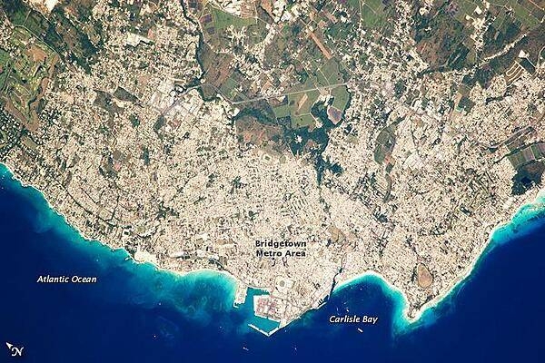
Bridgetown is the capital city of the island nation of Barbados, located to the east of the Lesser Antilles Island chain. While Barbados is considered part of the Lesser Antilles, it is located within the western Atlantic Ocean rather than the Caribbean Sea. Besides being the seat of government, Bridgetown is the largest city in Barbados. It and the surrounding towns that make up the Greater Bridgetown area are located along the southwestern coastline of the island. The metropolitan area is readily recognizable in this astronaut photograph due to the gray and white rooftops and street grids (image center) that contrast with green vegetated fields and riverside areas of the island's interior to the northeast (image top center). Bridgetown is a major port destination for both commercial and cruise ships serving the eastern Caribbean - several ships are visible within Carlisle Bay. Water color in the image changes from light blue along the coastline - indicating shallow water - to the dark blue of deeper water away from the island. Photo courtesy of NASA.
Bridgetown is the capital city of the island nation of Barbados, located to the east of the Lesser Antilles Island chain. While Barbados is considered part of the Lesser Antilles, it is located within the western Atlantic Ocean rather than the Caribbean Sea. Besides being the seat of government, Bridgetown is the largest city in Barbados. It and the surrounding towns that make up the Greater Bridgetown area are located along the southwestern coastline of the island. The metropolitan area is readily recognizable in this astronaut photograph due to the gray and white rooftops and street grids (image center) that contrast with green vegetated fields and riverside areas of the island's interior to the northeast (image top center). Bridgetown is a major port destination for both commercial and cruise ships serving the eastern Caribbean - several ships are visible within Carlisle Bay. Water color in the image changes from light blue along the coastline - indicating shallow water - to the dark blue of deeper water away from the island. Photo courtesy of NASA. • CIA World Factbook • 2020
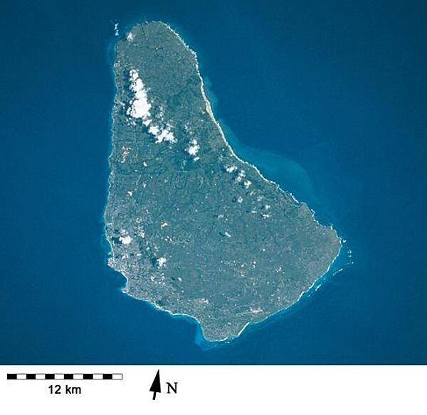
Barbados as seen from space. Fringing reefs around the island have declined over many decades although there are still submerged reefs off the west and southern coasts. Image courtesy of NASA.
Barbados as seen from space. Fringing reefs around the island have declined over many decades although there are still submerged reefs off the west and southern coasts. Image courtesy of NASA. • CIA World Factbook • 2020
2 photos available
Data sources: World Bank, UN Data • Updated daily •Learn about our data