›››
Congo, Dem. Rep.
Congo, Dem. Rep.
Population
109.3M
Rank #15Source: World Bank
Capital
Kinshasa
Source: REST Countries
Region
Africa
Sub-Saharan Africa
Source: REST Countries
GDP (Nominal)
$70.96B
Rank #87Source: World Bank
Land Area
2.3M km²
Rank #11Source: REST Countries
Life Expectancy
61.895 yrs
Source: World Bank
Historical Trends
Population Trend (5-Year)
Source: World Bank
GDP Trend (5-Year, Nominal USD)
Source: World Bank
Geography
Area: 2,344,858 km²
Landlocked: No
Independent: Yes
Climate: tropical; hot and humid in equatorial river basin; cooler and drier in southern highlands; cooler and wetter in eastern highlands; north of Equator - wet season (April to October), dry season...
Terrain: vast central basin is a low-lying plateau; mountains in east
Elevation: mean elevation: 726 m lowest point: Atlantic Ocean 0 m highest point: Pic Marguerite on Mont Ngaliema (Mount Stanley) 5,110 m
Natural Hazards: periodic droughts in south; Congo River floods (seasonal); active volcanoes in the east along the Great Rift Valleyvolcanism: Nyiragongo (3,470 m), which erupted in 2002 and is experiencing ongoing...
Environmental Issues: poaching threatens wildlife populations; water pollution; deforestation (forests endangered by fires set to clean the land for agricultural purposes; forests also used as a source of fuel); soil...
Land Use: agricultural land: 11.4% (2011 est.) forest: 67.9% (2011 est.) other: 20.7% (2011 est.)
Geography Note: note 1: second largest country in Africa (after Algeria) and largest country in Sub-Saharan Africa; straddles the equator; dense tropical rain forest in central river basin and eastern highlands; the...
Natural Resources
cobaltcopperniobiumtantalumpetroleumindustrial and gem diamondsgoldsilverzincmanganese
People & Society
Fertility Rate
6.05
Population
109.3M
Ethnic Groups
and the Mangbetu-Azande (Hamitic) - make up about (45%)
Religions
Roman Catholic (29.9%)Protestant (26.7%)Kimbanguist (2.8%)other Christian (36.5%)Muslim (1.3%)other (includes syncretic sects and indigenous beliefs) (1.2%)none (1.3%)unspecified (0.2%)
Economy
GDP per Capita
$649.383
GDP per Capita PPP
1,821.049
(2024)
(2024)
GNI per Capita
670
(2024)
(2024)
Gini Index
44.7
(2020)
(2020)
Unemployment
4.421%
(2024)
(2024)
Inflation
2.886%
(2016)
(2016)
Public Debt
14.941%
(2022)
(2022)
Energy
Electricity Access
22.1%
(2023)
(2023)
Renewable Energy
96.3%
(2021)
(2021)
CO₂ Emissions
6.21 Mt
(2024)
(2024)
Energy Intensity
12.51 MJ/$
(2021)
(2021)
Renewable Electricity
90.398%
(2021)
(2021)
Environment
Forest Coverage
54.19% of land
(2023)
(2023)
Communications
Internet Users
30.548%
(2023)
(2023)
Mobile Penetration
53.189%
(2023)
(2023)
Broadband Subscribers
0.022%
(2023)
(2023)
Transportation
Air Transport Freight
0.48 M ton-km
(2023)
(2023)
Container Port Traffic
42,211 TEU
(2019)
(2019)
Airports
9,822
Rail Lines
3,641 km
Roads Total
N/A
Military
Military Forces
Armed Forces of the Democratic Republic of the Congo (Forces d'Armees de la Republique Democratique du Congo, FARDC): Land Forces, National Navy (La Marine Nationale), Congolese Air Force (Force...
Personnel Strength
size estimates for the Armed Forces of the Democratic Republic of Congo (FARDC) vary widely because of inconsistent and unreliable data, as well as the ongoing integration of various non-state armed...
Military Expenditure (USD)
$0.90B
Military Expenditure (% of GDP)
1.23%
Military Expenditure History
0.7% of GDP (2019) 0.7% of GDP (2018) 0.7% of GDP (2017) 1.3% of GDP (2016) 1.4% of GDP (2015)
Equipment & Inventories
the FARDC is equipped mostly with a mix of second-hand Russian and Soviet-era weapons acquired from Ukraine and other former Warsaw Pact nations, as well as some equipment provided by Brazil and...
Service Age & Obligation
18-45 years of age for voluntary and compulsory military service
Education
Pre-Primary Enrollment
6.864%
(2020)
(2020)
Primary Enrollment
117.602%
(2023)
(2023)
Secondary Enrollment
55.486%
(2023)
(2023)
Tertiary Enrollment
6.38%
(2020)
(2020)
Education Spending
2.845% of GDP
(2022)
(2022)
Adult Literacy Rate
65.691%
(2020)
(2020)
Pupil-Teacher Ratio
33.198:1
(2015)
(2015)
Health
Physicians per 1,000
0.208
(2022)
(2022)
Safe Water Access
35.681%
(2024)
(2024)
Safe Drinking Water
11.873%
(2024)
(2024)
Under-5 Mortality
73.2 per 1,000
(2023)
(2023)
Maternal Mortality (World Bank)
15.399 per 100,000
(2021)
(2021)
Hospital Beds per 1,000
59.426
(2021)
(2021)
UHC Coverage Index
41
(2023)
(2023)
Measles Immunization
65%
(2024)
(2024)
Social Indicators
Extreme Poverty Rate
85.3%
(2020)
(2020)
Food Insecurity
38.5%
(2023)
(2023)
Youth NEET Rate
1.687%
(2020)
(2020)
Governance
Women in Government
12.998%
(2024)
(2024)
Voice & Accountability
-1.21
(Weak)
(2023)
(Weak)
(2023)
Political Stability
-2.04
(Weak)
(2023)
(Weak)
(2023)
Government Effectiveness
-1.69
(Weak)
(2023)
(Weak)
(2023)
Regulatory Quality
-1.41
(Weak)
(2023)
(Weak)
(2023)
Rule of Law
-1.67
(Weak)
(2023)
(Weak)
(2023)
Control of Corruption
-1.48
(Weak)
(2023)
(Weak)
(2023)
Government
Government Type
semi-presidential republic
Legal System
civil law system primarily based on Belgian law, but also customary and tribal law
Executive Branch
chief of state: President Felix TSHISEKEDI (since 24 January 2019) head of government: Prime Minister Sylvestre ILUNGA Ilunkamba (since 20 May 2019); Deputy Prime Ministers Jose MAKILA, Leonard She...
Legislative Branch
description: bicameral Parliament or Parlement consists of:Senate (108 seats; members indirectly elected by provincial assemblies by proportional representation vote; members serve 5-year terms)...
Judicial Branch
highest courts: Court of Cassation or Cour de Cassation (consists of 26 justices and organized into legislative and judiciary sections); Constitutional Court (consists of 9 judges) judge selection...
National Symbols
Flag Description
sky blue field divided diagonally from the lower hoist corner to upper fly corner by a red stripe bordered by two narrow yellow stripes; a yellow, five-pointed star appears in the upper hoist corner;...
National Symbols
leopard; national colors: sky blue, red, yellow
National Anthem
name: "Debout Congolaise" (Arise Congolese) lyrics/music: Joseph LUTUMBA/Simon-Pierre BOKA di Mpasi Londi note: adopted 1960; replaced when the country was known as Zaire; but readopted in 1997
Travel Information
Language(s): French, Kikongo, Lingala, +2 more
Currency: CDF (FC)
Timezone(s): UTC +01:00 to +02:00
Landlocked: No
Independent: Yes
Driving Side: Right
Calling Code: +243
Car Sign: CGO
Week Starts: Monday
Photos
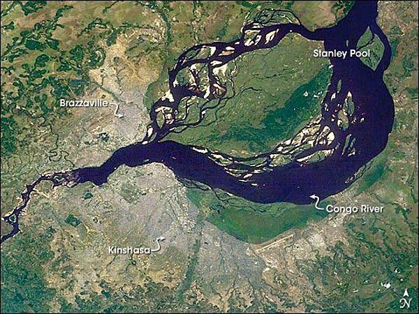
This astronaut image shows two capital cities (brownish-gray areas) on opposite banks of the Congo River. The smaller city on the north side of the river is Brazzaville, while the larger, Kinshasa, is on the south side. The cities lie at the downstream end of an almost circular widening in the river known as Stanley Pool. The international boundary follows the south shore of the pool (roughly 30 km in diameter). The Republic of the Congo, originally a French colony, is sometimes called Congo-Brazzaville - as opposed to the Democratic Republic of the Congo (known from 1971 to 1999 as Zaire) which is often called Congo-Kinshasa, originally a Belgian colony. Brazzaville's population is less than a tenth of Kinshasa's. There is no bridge between the cities so that water craft of many kinds ply between them. It is not uncommon to see dugout canoes being paddled between the cities. Photo courtesy of NASA.
This astronaut image shows two capital cities (brownish-gray areas) on opposite banks of the Congo River. The smaller city on the north side of the river is Brazzaville, while the larger, Kinshasa, is on the south side. The cities lie at the downstream end of an almost circular widening in the river known as Stanley Pool. The international boundary follows the south shore of the pool (roughly 30 km in diameter). The Republic of the Congo, originally a French colony, is sometimes called Congo-Brazzaville - as opposed to the Democratic Republic of the Congo (known from 1971 to 1999 as Zaire) which is often called Congo-Kinshasa, originally a Belgian colony. Brazzaville's population is less than a tenth of Kinshasa's. There is no bridge between the cities so that water craft of many kinds ply between them. It is not uncommon to see dugout canoes being paddled between the cities. Photo courtesy of NASA. • CIA World Factbook • 2020
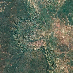
The Luizi Structure, located in southeastern Congo, is a crater covered by grasses up to a meter (3 ft) high. The crater seen in this satellite image has about a 17 km (11 mi) diameter, with an intermittent ring about 5.2 km (3.2 mi) across, and a smaller, center ring about 2 km (1.2 mi) across. Around the perimeter of the crater, a rim rises approximately 300 to 350 m (980 to 1,150 ft) above the interior. In short, Luizi is a well-preserved, moderately sized, complex crater. Exactly when Luizi formed is difficult to answer. Researchers estimate that nearby rocks are 575 million years old - more than 300 million years older than the first dinosaurs. But besides knowing that the impact cannot be older than the rock layers it disrupted, geologists still cannot say when the impact occurred. Photo courtesy of NASA.
The Luizi Structure, located in southeastern Congo, is a crater covered by grasses up to a meter (3 ft) high. The crater seen in this satellite image has about a 17 km (11 mi) diameter, with an intermittent ring about 5.2 km (3.2 mi) across, and a smaller, center ring about 2 km (1.2 mi) across. Around the perimeter of the crater, a rim rises approximately 300 to 350 m (980 to 1,150 ft) above the interior. In short, Luizi is a well-preserved, moderately sized, complex crater. Exactly when Luizi formed is difficult to answer. Researchers estimate that nearby rocks are 575 million years old - more than 300 million years older than the first dinosaurs. But besides knowing that the impact cannot be older than the rock layers it disrupted, geologists still cannot say when the impact occurred. Photo courtesy of NASA. • CIA World Factbook • 2020
2 photos available
Data sources: World Bank, UN Data • Updated daily •Learn about our data