›››
Eritrea
Eritrea
Population
3.5M
Rank #131Source: World Bank
Capital
Asmara
Source: REST Countries
Region
Africa
Sub-Saharan Africa
Source: REST Countries
GDP (Nominal)
$2.07B
Source: World Bank
Land Area
117.6K km²
Rank #100Source: REST Countries
Life Expectancy
68.624 yrs
Source: World Bank
Historical Trends
Population Trend (5-Year)
Source: World Bank
GDP Trend (5-Year, Nominal USD)
Source: World Bank
Geography
Area: 117,600 km²
Landlocked: No
Independent: Yes
Climate: hot, dry desert strip along Red Sea coast; cooler and wetter in the central highlands (up to 61 cm of rainfall annually, heaviest June to September); semiarid in western hills and lowlands
Terrain: dominated by extension of Ethiopian north-south trending highlands, descending on the east to a coastal desert plain, on the northwest to hilly terrain and on the southwest to flat-to-rolling plains
Elevation: mean elevation: 853 m lowest point: near Kulul within the Danakil Depression -75 m highest point: Soira 3,018 m
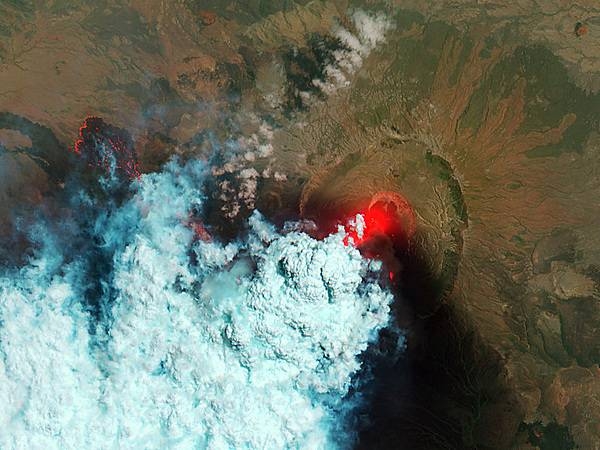
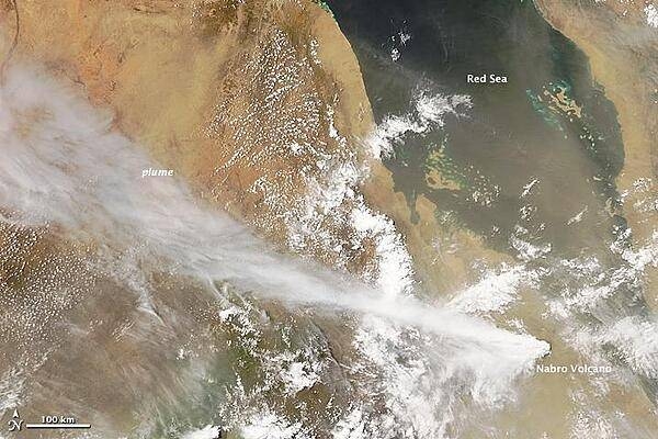
Natural Hazards: frequent droughts, rare earthquakes and volcanoes; locust swarmsvolcanism: Dubbi (1,625 m), which last erupted in 1861, was the country's only historically active volcano until Nabro (2,218 m) came...
Environmental Issues: deforestation; desertification; soil erosion; overgrazing
Land Use: agricultural land: 75.1% (2011 est.) forest: 15.1% (2011 est.) other: 9.8% (2011 est.)
Geography Note: strategic geopolitical position along world's busiest shipping lanes; Eritrea retained the entire coastline of Ethiopia along the Red Sea upon de jure independence from Ethiopia on 24 May 1993
Natural Resources
goldpotashzinccoppersaltpossibly oil and natural gasfish
People & Society
Fertility Rate
3.71
Population
3.5M
Ethnic Groups
Tigrinya (55%)Tigre (30%)Saho (4%)Kunama (2%)Rashaida (2%)Bilen (2%)other (Afar, Beni Amir, Nera) (5%)
Economy
GDP per Capita
$688.682
GDP per Capita PPP
1,742.324
(2011)
(2011)
GNI per Capita
650
(2011)
(2011)
Gini Index
Not Available
Unemployment
5.947%
(2024)
(2024)
Inflation
Not Available
Public Debt
Not Available
Energy
Electricity Access
54.4%
(2023)
(2023)
Renewable Energy
80.7%
(2021)
(2021)
CO₂ Emissions
0.778 Mt
(2024)
(2024)
Energy Intensity
6.37 MJ/$
(2021)
(2021)
Renewable Electricity
5.791%
(2021)
(2021)
Environment
Forest Coverage
8.63% of land
(2023)
(2023)
Communications
Internet Users
20.01%
(2023)
(2023)
Mobile Penetration
59.125%
(2022)
(2022)
Broadband Subscribers
0.165%
(2022)
(2022)
Transportation
Air Transport Freight
Not Available
Container Port Traffic
27,452.8 TEU
(2019)
(2019)
Airports
494.395
Rail Lines
N/A
Roads Total
16,000 km(©IRF)
Military
Military Forces
Eritrean Defense Forces: Eritrean Ground Forces, Eritrean Navy, Eritrean Air Force (includes Air Defense Force)
Personnel Strength
the Eritrean Defense Forces are comprised of an estimated 200,000 personnel, including about 2,000 in the naval and air forces; note – includes significant numbers of conscripts; it is unclear how...
Equipment & Inventories
the Eritrean Defense Forces inventory is comprised primarily of Soviet-era systems; Eritrea was under a UN arms embargo from 2009 to 2018; prior to 2009, Belarus, Bulgaria, and Russia were the...
Service Age & Obligation
18-40 years of age for male and female voluntary and compulsory military service; 18-month conscript service obligation
Education
Pre-Primary Enrollment
23.853%
(2019)
(2019)
Primary Enrollment
89.731%
(2022)
(2022)
Secondary Enrollment
44.044%
(2022)
(2022)
Tertiary Enrollment
3.203%
(2016)
(2016)
Education Spending
Not Available
Pupil-Teacher Ratio
38.741:1
(2018)
(2018)
Health
Physicians per 1,000
0.088
(2022)
(2022)
Safe Water Access
51.85%
(2016)
(2016)
Safe Drinking Water
Not Available
Under-5 Mortality
35.4 per 1,000
(2023)
(2023)
Maternal Mortality (World Bank)
13.634 per 100,000
(2021)
(2021)
Hospital Beds per 1,000
60.908
(2021)
(2021)
UHC Coverage Index
40
(2023)
(2023)
Measles Immunization
95%
(2024)
(2024)
Governance
Women in Government
Not Available
Voice & Accountability
-1.86
(Weak)
(2023)
(Weak)
(2023)
Political Stability
-0.79
(Below Average)
(2023)
(Below Average)
(2023)
Government Effectiveness
-1.79
(Weak)
(2023)
(Weak)
(2023)
Regulatory Quality
-2.36
(Weak)
(2023)
(Weak)
(2023)
Rule of Law
-1.76
(Weak)
(2023)
(Weak)
(2023)
Control of Corruption
-1.48
(Weak)
(2023)
(Weak)
(2023)
Government
Government Type
presidential republic
Legal System
mixed legal system of civil, customary, and Islamic religious law
Executive Branch
chief of state: President ISAIAS Afwerki (since 8 June 1993); note - the president is both chief of state and head of government and is head of the State Council and National Assembly head of...
Legislative Branch
description: unicameral National Assembly (Hagerawi Baito) (150 seats; 75 members indirectly elected by the ruling party and 75 directly elected by simple majority vote; members serve 5-year...
Judicial Branch
highest courts: High Court (consists of 20 judges and organized into civil, commercial, criminal, labor, administrative, and customary sections) judge selection and term of office: High Court judges...
National Symbols
Flag Description
red isosceles triangle (based on the hoist side) dividing the flag into two right triangles; the upper triangle is green, the lower one is blue; a gold wreath encircling a gold olive branch is...
National Symbols
camel; national colors: green, red, blue
National Anthem
name: "Ertra, Ertra, Ertra" (Eritrea, Eritrea, Eritrea) lyrics/music: SOLOMON Tsehaye Beraki/Isaac Abraham MEHAREZGI and ARON Tekle Tesfatsion note: adopted 1993; upon independence from Ethiopia
Safety
Homicide Rate
15.608 per 100,000
(2012)
(2012)
Travel Information
Language(s): Arabic, English, Tigrinya
Currency: ERN (Nfk)
Timezone(s): UTC+03:00
Landlocked: No
Independent: Yes
Driving Side: Right
Calling Code: +291
Car Sign: ER
Week Starts: Monday
Photos
CIA World Factbook • 2020
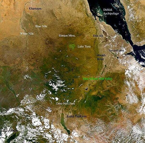
At the top left, the capital city of Sudan, Khartoum, is located at the convergence of the Blue Nile and the White Nile. Although the Blue Nile is much shorter than the White Nile, it contributes about 80% of the flow of the river. The Dahlak Archipelago is seen off the Red Sea coast of Eritrea. Because of their isolation, the numerous coral reefs of the Dahlak Archipelago are some of the most pristine in the world. North of the Rift Valley, in central Ethiopia, are the Simien Mountains and Lake Tana. Lake Tana is the source of the Blue Nile. Photo courtesy of NASA.
At the top left, the capital city of Sudan, Khartoum, is located at the convergence of the Blue Nile and the White Nile. Although the Blue Nile is much shorter than the White Nile, it contributes about 80% of the flow of the river. The Dahlak Archipelago is seen off the Red Sea coast of Eritrea. Because of their isolation, the numerous coral reefs of the Dahlak Archipelago are some of the most pristine in the world. North of the Rift Valley, in central Ethiopia, are the Simien Mountains and Lake Tana. Lake Tana is the source of the Blue Nile. Photo courtesy of NASA. • CIA World Factbook • 2020
CIA World Factbook • 2020
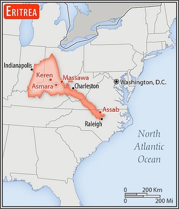
Area comparison map
Area comparison map • CIA World Factbook • 2020
4 photos available
Data sources: World Bank, UN Data • Updated daily •Learn about our data