›››
Grenada
Grenada
Population
117.2K
Rank #189Source: World Bank
Capital
Saint George's
Source: REST Countries
Region
Americas
Latin America & Caribbean
Source: REST Countries
GDP (Nominal)
$1.37B
Rank #182Source: World Bank
Land Area
344 km²
Rank #198Source: REST Countries
Life Expectancy
75.205 yrs
Source: World Bank
Historical Trends
Population Trend (5-Year)
Source: World Bank
GDP Trend (5-Year, Nominal USD)
Source: World Bank
Geography
Area: 344 km²
Landlocked: No
Independent: Yes
Climate: tropical; tempered by northeast trade winds
Terrain: volcanic in origin with central mountains
Elevation: lowest point: Caribbean Sea 0 m highest point: Mount Saint Catherine 840 m
Natural Hazards: lies on edge of hurricane belt; hurricane season lasts from June to Novembervolcanism: Mount Saint Catherine (840 m) lies on the island of Grenada; Kick 'em Jenny, an active submarine volcano...
Environmental Issues: deforestation causing habitat destruction and species loss; coastal erosion and contamination; pollution and sedimentation; inadequate solid waste management
Land Use: agricultural land: 32.3% (2011 est.) forest: 50% (2011 est.) other: 17.7% (2011 est.)
Geography Note: the administration of the islands of the Grenadines group is divided between Saint Vincent and the Grenadines and Grenada
Natural Resources
timbertropical fruit
People & Society
Fertility Rate
1.49
Population
117.2K
Ethnic Groups
African descent (82.4%)mixed (13.3%)East Indian (2.2%)other (1.3%)unspecified (0.9%)
Religions
Protestant 49.2% (includes Pentecostal (17.2%)Seventh Day Adventist (13.2%)Anglican (8.5%)Baptist (3.2%)Church of God (2.4%)Evangelical (1.9%)Methodist (1.6%)other (1.2%)Roman Catholic (36%)Jehovah's Witness (1.2%)Rastafarian (1.2%)other (5.5%)none (5.7%)unspecified (1.3%)
Economy
GDP per Capita
$11,705.09
GDP per Capita PPP
20,177.809
(2024)
(2024)
GNI per Capita
10,510
(2024)
(2024)
Gini Index
43.8
(2018)
(2018)
Unemployment
Not Available
Inflation
1.086%
(2024)
(2024)
Public Debt
Not Available
Energy
Electricity Access
94.4%
(2023)
(2023)
Renewable Energy
10%
(2022)
(2022)
CO₂ Emissions
0.176 Mt
(2024)
(2024)
Energy Intensity
2.67 MJ/$
(2022)
(2022)
Renewable Electricity
1.966%
(2021)
(2021)
Environment
Forest Coverage
52.059% of land
(2023)
(2023)
Communications
Internet Users
74.12%
(2023)
(2023)
Mobile Penetration
95.759%
(2022)
(2022)
Broadband Subscribers
29.767%
(2022)
(2022)
Transportation
Air Transport Freight
Not Available
Container Port Traffic
22,117 TEU
(2021)
(2021)
Airports
N/A
Rail Lines
N/A
Roads Total
N/A
Military
Military Forces
no regular military forces; Royal Grenada Police Force (includes Coast Guard)
Education
Pre-Primary Enrollment
130.813%
(2020)
(2020)
Primary Enrollment
110.591%
(2024)
(2024)
Secondary Enrollment
100.732%
(2024)
(2024)
Tertiary Enrollment
99.989%
(2018)
(2018)
Education Spending
5.125% of GDP
(2023)
(2023)
Pupil-Teacher Ratio
16.351:1
(2018)
(2018)
Health
Physicians per 1,000
1.383
(2018)
(2018)
Safe Water Access
95.629%
(2017)
(2017)
Safe Drinking Water
89.918%
(2017)
(2017)
Under-5 Mortality
18.3 per 1,000
(2023)
(2023)
Maternal Mortality (World Bank)
20.213 per 100,000
(2021)
(2021)
Hospital Beds per 1,000
75.201
(2021)
(2021)
UHC Coverage Index
78
(2023)
(2023)
Measles Immunization
93%
(2024)
(2024)
Social Indicators
Extreme Poverty Rate
0.8%
(2018)
(2018)
Food Insecurity
Not Available
Youth NEET Rate
18.137%
(2023)
(2023)
Governance
Women in Government
31.25%
(2024)
(2024)
Voice & Accountability
0.75
(Above Average)
(2023)
(Above Average)
(2023)
Political Stability
1.02
(Strong)
(2023)
(Strong)
(2023)
Government Effectiveness
-0.01
(Below Average)
(2023)
(Below Average)
(2023)
Regulatory Quality
0.32
(Above Average)
(2023)
(Above Average)
(2023)
Rule of Law
0.60
(Above Average)
(2023)
(Above Average)
(2023)
Control of Corruption
0.56
(Above Average)
(2023)
(Above Average)
(2023)
Government
Government Type
parliamentary democracy under a constitutional monarchy; a Commonwealth realm
Legal System
common law based on English model
Executive Branch
chief of state: Queen ELIZABETH II (since 6 February 1952); represented by Governor General Cecile LA GRENADE (since 7 May 2013) head of government: Prime Minister Keith MITCHELL (since 20 February...
Legislative Branch
description: bicameral Parliament consists of:Senate (13 seats; members appointed by the governor general - 10 on the advice of the prime minister and 3 on the advice of the leader of the opposition...
Judicial Branch
highest courts: regionally, the Eastern Caribbean Supreme Court (ECSC) is the superior court of the Organization of Eastern Caribbean States; the ECSC - headquartered on St. Lucia - consists of the...
National Symbols
Flag Description
a rectangle divided diagonally into yellow triangles (top and bottom) and green triangles (hoist side and outer side), with a red border around the flag; there are seven yellow, five-pointed stars...
National Symbols
Grenada dove, bougainvillea flower; national colors: red, yellow, green
National Anthem
name: Hail Grenada lyrics/music: Irva Merle BAPTISTE/Louis Arnold MASANTO note: adopted 1974
Safety
Homicide Rate
13.666 per 100,000
(2023)
(2023)
Travel Information
Language(s): English
Currency: XCD ($)
Timezone(s): UTC-04:00
Landlocked: No
Independent: Yes
Driving Side: Left
Calling Code: +1
Car Sign: WG
Week Starts: Monday
Photos
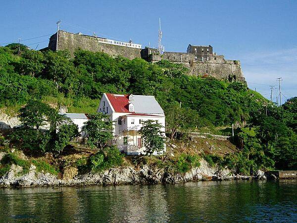
A view of Fort Rupert as seen from the entry to the harbor of St. George's.
A view of Fort Rupert as seen from the entry to the harbor of St. George's. • CIA World Factbook • 2020
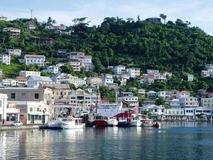
The harbor of St. George's.
The harbor of St. George's. • CIA World Factbook • 2020
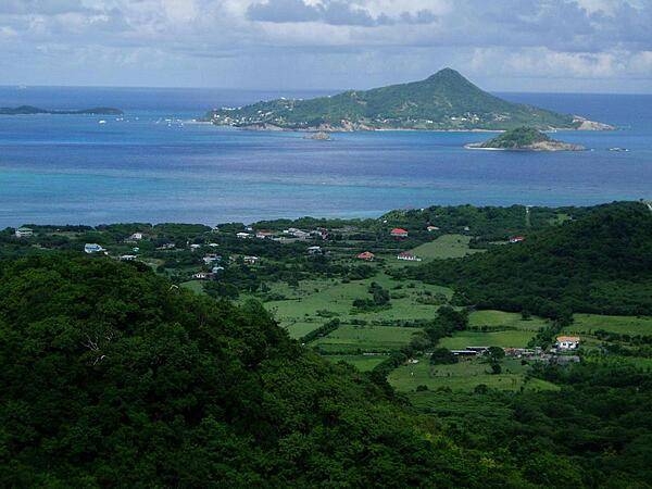
Photo taken from the island of Carriacau, part of Grenada. The island visible on the horizon is Petit Martinique, also part of Grenadan territory.
Photo taken from the island of Carriacau, part of Grenada. The island visible on the horizon is Petit Martinique, also part of Grenadan territory. • CIA World Factbook • 2020
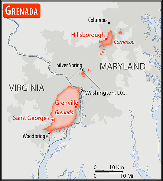
Area comparison map
Area comparison map • CIA World Factbook • 2020
4 photos available
Data sources: World Bank, UN Data • Updated daily •Learn about our data