›››
Greenland
Greenland
Population
56.8K
Rank #201Source: World Bank
Capital
Nuuk
Source: REST Countries
Region
Europe
Europe & Central Asia
Source: REST Countries
GDP (Nominal)
$3.33B
Source: World Bank
Land Area
2.2M km²
Rank #12Source: REST Countries
Life Expectancy
71.55 yrs
Source: World Bank
Historical Trends
Population Trend (5-Year)
Source: World Bank
GDP Trend (5-Year, Nominal USD)
Source: World Bank
Geography
Area: 2,166,086 km²
Landlocked: No
Independent: No
Climate: arctic to subarctic; cool summers, cold winters
Terrain: flat to gradually sloping icecap covers all but a narrow, mountainous, barren, rocky coast
Elevation: mean elevation: 1,792 m lowest point: Atlantic Ocean 0 m highest point: Gunnbjorn Fjeld 3,694 m
Natural Hazards: continuous permafrost over northern two-thirds of the island
Environmental Issues: especially vulnerable to climate change and disruption of the Arctic environment; preservation of the Inuit traditional way of life, including whaling and seal hunting
Land Use: agricultural land: 0.6% (2011 est.) forest: 0% (2011 est.) other: 99.4% (2011 est.)
Geography Note: dominates North Atlantic Ocean between North America and Europe; sparse population confined to small settlements along coast; close to one-quarter of the population lives in the capital, Nuuk;...
Natural Resources
coaliron oreleadzincmolybdenumdiamondsgoldplatinumniobiumtantalite
People & Society
Fertility Rate
1.77
Population
56.8K
Ethnic Groups
Greenlandic (89.5%)Danish (7.5%)other Nordic peoples (1.1%)and other (1.9%)
Economy
GDP per Capita
$58,498.971
GDP per Capita PPP
78,840.598
(2023)
(2023)
GNI per Capita
Not Available
Gini Index
Not Available
Unemployment
Not Available
Inflation
Not Available
Public Debt
Not Available
Energy
Electricity Access
100%
(2023)
(2023)
Renewable Energy
11.7%
(2022)
(2022)
CO₂ Emissions
0.594 Mt
(2024)
(2024)
Energy Intensity
Not Available
Renewable Electricity
77.042%
(2021)
(2021)
Environment
Forest Coverage
0.001% of land
(2023)
(2023)
Communications
Internet Users
69.483%
(2017)
(2017)
Mobile Penetration
118.637%
(2022)
(2022)
Broadband Subscribers
31.984%
(2022)
(2022)
Transportation
Air Transport Freight
Not Available
Container Port Traffic
6,144.526 TEU
(2019)
(2019)
Airports
N/A
Rail Lines
N/A
Roads Total
N/A
Military
Military Forces
no regular military forces or conscription.
Health
Physicians per 1,000
Not Available
Safe Water Access
100%
(2024)
(2024)
Safe Drinking Water
Not Available
Under-5 Mortality
Not Available
Maternal Mortality (World Bank)
Not Available
Governance
Women in Government
Not Available
Voice & Accountability
1.27
(Strong)
(2023)
(Strong)
(2023)
Political Stability
1.50
(Strong)
(2023)
(Strong)
(2023)
Government Effectiveness
0.76
(Above Average)
(2023)
(Above Average)
(2023)
Regulatory Quality
1.21
(Strong)
(2023)
(Strong)
(2023)
Rule of Law
1.68
(Strong)
(2023)
(Strong)
(2023)
Control of Corruption
1.03
(Strong)
(2023)
(Strong)
(2023)
Government
Government Type
parliamentary democracy (Parliament of Greenland or Inatsisartut)
Legal System
the laws of Denmark apply where applicable and Greenlandic law applies to other areas
Executive Branch
chief of state: Queen MARGRETHE II of Denmark (since 14 January 1972), represented by High Commissioner Mikaela ENGELL (since April 2011) head of government: Premier Kim KIELSEN (since 30 September...
Legislative Branch
description: unicameral Parliament or Inatsisartut (31 seats; members directly elected in multi-seat constituencies by proportional representation vote to serve 4-year terms)Greenland elects 2...
Judicial Branch
highest courts: High Court of Greenland (consists of the presiding professional judge and 2 lay assessors); note - appeals beyond the High Court of Greenland can be heard by the Supreme Court (in...
National Symbols
Flag Description
two equal horizontal bands of white (top) and red with a large disk slightly to the hoist side of center - the top half of the disk is red, the bottom half is white; the design represents the sun...
National Symbols
polar bear; national colors: red, white
National Anthem
name: "Nunarput utoqqarsuanngoravit" ("Our Country, Who's Become So Old" also translated as "You Our Ancient Land") lyrics/music: Henrik LUND/Jonathan PETERSEN note: adopted 1916; the government also...
Safety
Homicide Rate
5.351 per 100,000
(2016)
(2016)
Travel Information
Language(s): Greenlandic
Currency: DKK (kr.)
Timezone(s): UTC +00:00 to -04:00
Landlocked: No
Independent: No
Driving Side: Right
Calling Code: +299
Car Sign: DK
Week Starts: Monday
Photos
The calving front of Kangerdlugssup Glacier in central west Greenland where icebergs are born. You can see several large ice bergs in the fjord on the right surrounded by the so called mélange, which is a dense mix of bergy bits and sea ice floating in the fjord. The mélange plays a role in how many ice bergs a glacier can produce by stabilizing the calving front. Credit: NASA/Michael Studinger.
The calving front of Kangerdlugssup Glacier in central west Greenland where icebergs are born. You can see several large ice bergs in the fjord on the right surrounded by the so called mélange, which is a dense mix of bergy bits and sea ice floating in the fjord. The mélange plays a role in how many ice bergs a glacier can produce by stabilizing the calving front. Credit: NASA/Michael Studinger. • CIA World Factbook • 2020
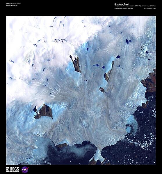
Along Greenland's western coast, a small field of glaciers empties into Baffin Bay, 80% of which is covered by ice in winter. Calving icebergs may be seen in the lower right of this high-resolution satellite photo. Baffin Bay is only 1,000 m (3,300 ft) deep along the coast. Between May and July a polynya, an area of navigable open water surrounded by sea ice, forms at the northern part of the bay. This polynya, the largest in the Canadian Arctic, is stable in location and has existed for nearly 9,000 years. Image courtesy of USGS.
Along Greenland's western coast, a small field of glaciers empties into Baffin Bay, 80% of which is covered by ice in winter. Calving icebergs may be seen in the lower right of this high-resolution satellite photo. Baffin Bay is only 1,000 m (3,300 ft) deep along the coast. Between May and July a polynya, an area of navigable open water surrounded by sea ice, forms at the northern part of the bay. This polynya, the largest in the Canadian Arctic, is stable in location and has existed for nearly 9,000 years. Image courtesy of USGS. • CIA World Factbook • 2020
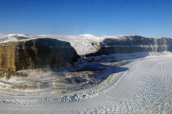
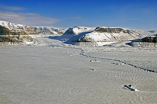
The Steensby Glacier in norothern Greenland flows around a sharp bend in a deep canyon. The glacier is located at 81 degrees north in Nyboe Land and flows into the St. Georges Fjord. Credit: NASA/Michael Studinger.
The Steensby Glacier in norothern Greenland flows around a sharp bend in a deep canyon. The glacier is located at 81 degrees north in Nyboe Land and flows into the St. Georges Fjord. Credit: NASA/Michael Studinger. • CIA World Factbook • 2020
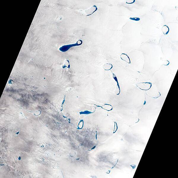
Each spring and summer, as the air warms up and the sunlight beats down on the Greenland ice sheet, sapphire-colored ponds spring up like swimming pools. As snow and ice melt atop the glaciers, the water flows in channels and streams and collects in depressions on the surface that are sometimes visible in satellite imagery. These melt ponds and lakes can disappear quickly - a phenomenon that scientists have observed firsthand in recent years. Photo courtesy of NASA.
Each spring and summer, as the air warms up and the sunlight beats down on the Greenland ice sheet, sapphire-colored ponds spring up like swimming pools. As snow and ice melt atop the glaciers, the water flows in channels and streams and collects in depressions on the surface that are sometimes visible in satellite imagery. These melt ponds and lakes can disappear quickly - a phenomenon that scientists have observed firsthand in recent years. Photo courtesy of NASA. • CIA World Factbook • 2020
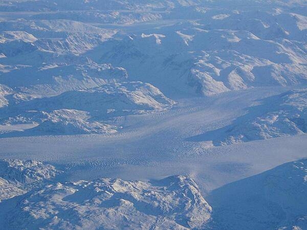
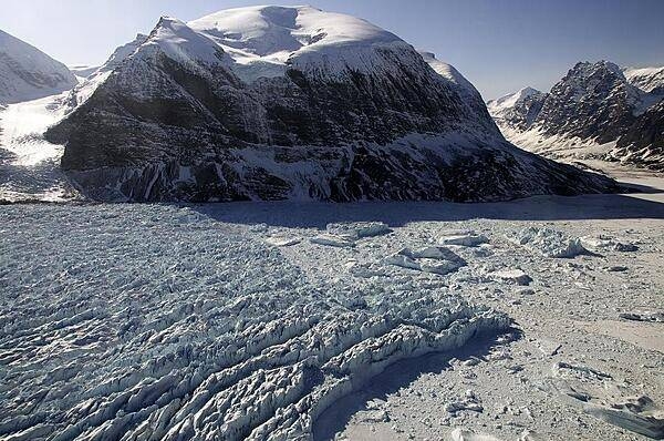
Glaciers in the fjords of Greenland, as seen from the air.
Glaciers in the fjords of Greenland, as seen from the air. • CIA World Factbook • 2020
The calving front of Petermann Glacier in northern Greenland as seen from a NASA P-3B. In July 2012 an iceberg twice the size of Manhattan broke off of Petermann Glacier and began to float away in the ocean. After this calving event the line where the iceberg broke away became the glacier's new front edge, or calving front, effectively moving it several kilometers upstream. Credit: NASA/Michael Studinger.
The calving front of Petermann Glacier in northern Greenland as seen from a NASA P-3B. In July 2012 an iceberg twice the size of Manhattan broke off of Petermann Glacier and began to float away in the ocean. After this calving event the line where the iceberg broke away became the glacier's new front edge, or calving front, effectively moving it several kilometers upstream. Credit: NASA/Michael Studinger. • CIA World Factbook • 2020
24 photos available
View All Photos→Data sources: World Bank, UN Data • Updated daily •Learn about our data