›››
Equatorial Guinea
Equatorial Guinea
Population
1.9M
Rank #149Source: World Bank
Capital
Malabo
Source: REST Countries
Region
Africa
Sub-Saharan Africa
Source: REST Countries
GDP (Nominal)
$12.77B
Rank #144Source: World Bank
Land Area
28.1K km²
Rank #142Source: REST Countries
Life Expectancy
63.707 yrs
Source: World Bank
Historical Trends
Population Trend (5-Year)
Source: World Bank
GDP Trend (5-Year, Nominal USD)
Source: World Bank
Geography
Area: 28,051 km²
Landlocked: No
Independent: Yes
Climate: tropical; always hot, humid
Terrain: coastal plains rise to interior hills; islands are volcanic
Elevation: mean elevation: 577 m lowest point: Atlantic Ocean 0 m highest point: Pico Basile 3,008 m
Natural Hazards: violent windstorms; flash floodsvolcanism: Santa Isabel (3,007 m), which last erupted in 1923, is the country's only historically active volcano; Santa Isabel, along with two dormant volcanoes, form...
Environmental Issues: deforestation (forests are threatened by agricultural expansion, fires, and grazing); desertification; water pollution (tap water is non-potable); wildlife preservation
Land Use: agricultural land: 10.1% (2011 est.) forest: 57.5% (2011 est.) other: 32.4% (2011 est.)
Geography Note: insular and continental regions widely separated; despite its name, no part of the Equator passes through Equatorial Guinea; the mainland part of the country is located just north of the Equator
Natural Resources
petroleumnatural gastimbergoldbauxitediamondstantalumsand and gravelclay
People & Society
Fertility Rate
4.08
Population
1.9M
Ethnic Groups
Fang (85.7%)Bubi (6.5%)Mdowe (3.6%)Annobon (1.6%)Bujeba (1.1%)other (1.4%)
Economy
GDP per Capita
$6,745.4
GDP per Capita PPP
17,566.76
(2024)
(2024)
GNI per Capita
4,740
(2024)
(2024)
Gini Index
38.5
(2022)
(2022)
Unemployment
8.293%
(2024)
(2024)
Inflation
2.921%
(2024)
(2024)
Public Debt
Not Available
Energy
Electricity Access
66.9%
(2023)
(2023)
Renewable Energy
4.2%
(2022)
(2022)
CO₂ Emissions
4.827 Mt
(2024)
(2024)
Energy Intensity
5.9 MJ/$
(2022)
(2022)
Renewable Electricity
8.805%
(2021)
(2021)
Environment
Forest Coverage
86.394% of land
(2023)
(2023)
Communications
Internet Users
60.366%
(2023)
(2023)
Mobile Penetration
49.538%
(2022)
(2022)
Broadband Subscribers
0.101%
(2022)
(2022)
Transportation
Air Transport Freight
0.8 M ton-km
(2023)
(2023)
Container Port Traffic
6,207 TEU
(2020)
(2020)
Airports
3,063
Rail Lines
N/A
Roads Total
N/A
Military
Military Forces
Equatorial Guinea Armed Forces (FAGE): Equatorial Guinea National Guard (Guardia Nacional de Guinea Ecuatorial, GNGE (Army), Navy, Air Force; Guardia Civil (paramilitary force for internal security)
Personnel Strength
the Equatorial Guinea Armed Forces (FAGE) have approximately 1,400 active duty troops (1,100 Army; 200 Navy; 100 Air Force)
Military Expenditure (USD)
$0.11B
Military Expenditure (% of GDP)
0.98%
Military Expenditure History
1.1% of GDP (2018) 1.1% of GDP (2017) 1.2% of GDP (2016) 1% of GDP (2015)
Equipment & Inventories
the FAGE is armed with mostly second-hand Russian and Soviet-era weapons; Ukraine is the leading provider of equipment since 2010 followed by Israel (2019 est.)
Service Age & Obligation
18 years of age for selective compulsory military service, although conscription is rare in practice; 2-year service obligation; women hold only administrative positions in the Navy
Education
Pre-Primary Enrollment
43.362%
(2015)
(2015)
Primary Enrollment
47.549%
(2015)
(2015)
Secondary Enrollment
Not Available
Tertiary Enrollment
Not Available
Education Spending
Not Available
Pupil-Teacher Ratio
23.227:1
(2015)
(2015)
Health
Physicians per 1,000
0.153
(2022)
(2022)
Safe Water Access
64.666%
(2017)
(2017)
Safe Drinking Water
Not Available
Under-5 Mortality
70.6 per 1,000
(2023)
(2023)
Maternal Mortality (World Bank)
16.579 per 100,000
(2021)
(2021)
Hospital Beds per 1,000
61.605
(2021)
(2021)
UHC Coverage Index
49
(2023)
(2023)
Measles Immunization
68%
(2024)
(2024)
Social Indicators
Extreme Poverty Rate
8.8%
(2022)
(2022)
Food Insecurity
Not Available
Youth NEET Rate
Not Available
Governance
Women in Government
32%
(2024)
(2024)
Voice & Accountability
-1.68
(Weak)
(2023)
(Weak)
(2023)
Political Stability
-0.23
(Below Average)
(2023)
(Below Average)
(2023)
Government Effectiveness
-1.32
(Weak)
(2023)
(Weak)
(2023)
Regulatory Quality
-1.47
(Weak)
(2023)
(Weak)
(2023)
Rule of Law
-1.34
(Weak)
(2023)
(Weak)
(2023)
Control of Corruption
-1.57
(Weak)
(2023)
(Weak)
(2023)
Government
Government Type
presidential republic
Legal System
mixed system of civil and customary law
Executive Branch
chief of state: President Brig. Gen. (Ret.) Teodoro OBIANG Nguema Mbasogo (since 3 August 1979 when he seized power in a military coup); Vice President Teodoro Nguema OBIANG Mangue(since 2012) head...
Legislative Branch
description: bicameral National Assembly or Asemblea Nacional consists of:Senate or Senado (70 seats; 55 members directly elected in multi-seat constituencies by closed party-list proportional...
Judicial Branch
highest courts: Supreme Court of Justice (consists of the chief justice - who is also chief of state - and 9 judges organized into civil, criminal, commercial, labor, administrative, and customary...
International Organizations
National Symbols
Flag Description
three equal horizontal bands of green (top), white, and red, with a blue isosceles triangle based on the hoist side and the coat of arms centered in the white band; the coat of arms has six yellow...
National Symbols
silk cotton tree; national colors: green, white, red, blue
National Anthem
name: "Caminemos pisando la senda" (Let Us Tread the Path) lyrics/music: Atanasio Ndongo MIYONO/Atanasio Ndongo MIYONO or Ramiro Sanchez LOPEZ (disputed) note: adopted 1968
Travel Information
Language(s): French, Portuguese, Spanish
Currency: XAF (Fr)
Timezone(s): UTC+01:00
Landlocked: No
Independent: Yes
Driving Side: Right
Calling Code: +240
Car Sign: GQ
Week Starts: Monday
Photos
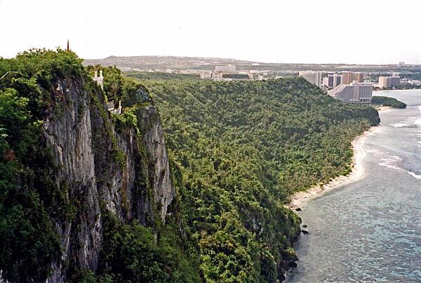
Two Lovers' Point is located near the island's major resort areas.
Two Lovers' Point is located near the island's major resort areas. • CIA World Factbook • 2020
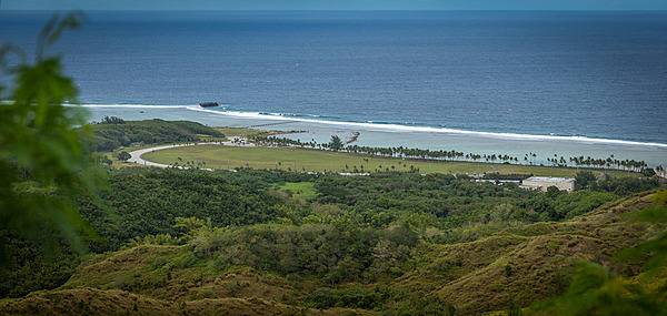
View from Asan Bay Overlook toward the War in the Pacific National Historical Park. This photo illustrates the perspective of the Japanese defenders when US forces landed on 21 July 1944. Despite an intense pre-invasion bombardment, the 3rd Marine Division encountered significant opposition as they came ashore on the beaches of Asan Bay. Photo courtesy of the US National Park Service.
View from Asan Bay Overlook toward the War in the Pacific National Historical Park. This photo illustrates the perspective of the Japanese defenders when US forces landed on 21 July 1944. Despite an intense pre-invasion bombardment, the 3rd Marine Division encountered significant opposition as they came ashore on the beaches of Asan Bay. Photo courtesy of the US National Park Service. • CIA World Factbook • 2020
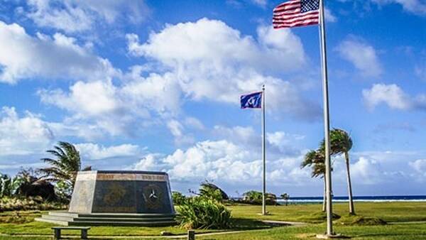
A hexagonal monument, dedicated in 1994 on the 50th anniversary of the liberation of Guam, stands at the War in the Pacific National Historical Park under the flags of the United States and Guam. The monument's inscription reads: "Honors to heroic and gallant effort of the US Armed Forces". Photo courtesy of the US National Park Service.
A hexagonal monument, dedicated in 1994 on the 50th anniversary of the liberation of Guam, stands at the War in the Pacific National Historical Park under the flags of the United States and Guam. The monument's inscription reads: "Honors to heroic and gallant effort of the US Armed Forces". Photo courtesy of the US National Park Service. • CIA World Factbook • 2020
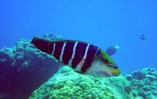
A barred thicklip off the waters of Guam. The fish is named a'aga in Chamorro. Photo courtesy of the US National Park Service.
A barred thicklip off the waters of Guam. The fish is named a'aga in Chamorro. Photo courtesy of the US National Park Service. • CIA World Factbook • 2020
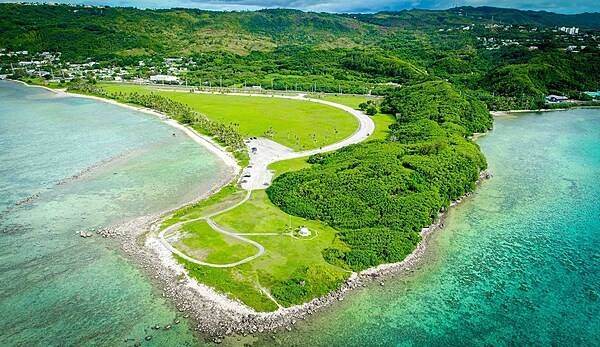
Aerial view of Asan Ridge and the War in the Pacific National Historical Park. Established in 1978, the Park is composed of various sites on the western shore of the island; it is unique in the US National Park System in that it honors all those who participated in the Pacific Theater of World War II. During the Second World War, Guam was captured by Japanese forces in 1941 and liberated by the Americans in 1944. The Park includes former battlefields, gun emplacements, trenches, caves, and historic structures. Photo courtesy of the US National Park Service.
Aerial view of Asan Ridge and the War in the Pacific National Historical Park. Established in 1978, the Park is composed of various sites on the western shore of the island; it is unique in the US National Park System in that it honors all those who participated in the Pacific Theater of World War II. During the Second World War, Guam was captured by Japanese forces in 1941 and liberated by the Americans in 1944. The Park includes former battlefields, gun emplacements, trenches, caves, and historic structures. Photo courtesy of the US National Park Service. • CIA World Factbook • 2020
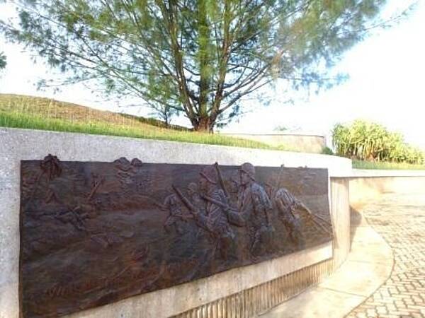
Bronze relief on a memorial at the War in the Pacific National Historical Park. Established in 1978, the Park is composed of various sites on the western shore of the island; it is unique in the US National Park System in that it honors all those who participated in the Pacific Theater of World War II. During the Second World War, Guam was captured by Japanese forces in 1941 and liberated by the Americans in 1944. The Park includes former battlefields, gun emplacements, trenches, caves, and historic structures. Photo courtesy of the US National Park Service.
Bronze relief on a memorial at the War in the Pacific National Historical Park. Established in 1978, the Park is composed of various sites on the western shore of the island; it is unique in the US National Park System in that it honors all those who participated in the Pacific Theater of World War II. During the Second World War, Guam was captured by Japanese forces in 1941 and liberated by the Americans in 1944. The Park includes former battlefields, gun emplacements, trenches, caves, and historic structures. Photo courtesy of the US National Park Service. • CIA World Factbook • 2020
12 photos available
View All Photos→Data sources: World Bank, UN Data • Updated daily •Learn about our data