›››
Haiti
Haiti
Population
11.8M
Rank #82Source: World Bank
Capital
Port-au-Prince
Source: REST Countries
Region
Americas
Latin America & Caribbean
Source: REST Countries
GDP (Nominal)
$25.22B
Rank #117Source: World Bank
Land Area
27.8K km²
Rank #144Source: REST Countries
Life Expectancy
64.936 yrs
Source: World Bank
Historical Trends
Population Trend (5-Year)
Source: World Bank
GDP Trend (5-Year, Nominal USD)
Source: World Bank
Geography
Area: 27,750 km²
Landlocked: No
Independent: Yes
Climate: tropical; semiarid where mountains in east cut off trade winds
Terrain: mostly rough and mountainous
Elevation: mean elevation: 470 m lowest point: Caribbean Sea 0 m highest point: Chaine de la Selle 2,680 m
Natural Hazards: lies in the middle of the hurricane belt and subject to severe storms from June to October; occasional flooding and earthquakes; periodic droughts
Environmental Issues: extensive deforestation (much of the remaining forested land is being cleared for agriculture and used as fuel); soil erosion; overpopulation leads to inadequate supplies of potable water and and a...
Land Use: agricultural land: 66.4% (2011 est.) forest: 3.6% (2011 est.) other: 30% (2011 est.)
Geography Note: shares island of Hispaniola with Dominican Republic (western one-third is Haiti, eastern two-thirds is the Dominican Republic); it is the most mountainous nation in the Caribbean
Natural Resources
bauxitecoppercalcium carbonategoldmarblehydropowerarable land
People & Society
Fertility Rate
2.66
Population
11.8M
Ethnic Groups
Black (95%)mixed and White (5%)
Religions
Roman Catholic (54.7%)Protestant 28.5% (Baptist (15.4%)Pentecostal (7.9%)Adventist (3%)Methodist (1.5%)other (0.7%)Vodou (2.1%)other (4.6%)none (10.2%)
Economy
GDP per Capita
$2,142.623
GDP per Capita PPP
3,193.671
(2024)
(2024)
GNI per Capita
1,760
(2024)
(2024)
Gini Index
41.1
(2012)
(2012)
Unemployment
14.609%
(2024)
(2024)
Inflation
26.949%
(2024)
(2024)
Public Debt
Not Available
Energy
Electricity Access
51.3%
(2023)
(2023)
Renewable Energy
76.7%
(2021)
(2021)
CO₂ Emissions
3.514 Mt
(2024)
(2024)
Energy Intensity
5.88 MJ/$
(2021)
(2021)
Renewable Electricity
19.845%
(2021)
(2021)
Environment
Forest Coverage
12.263% of land
(2023)
(2023)
Communications
Internet Users
39.262%
(2019)
(2019)
Mobile Penetration
65.189%
(2022)
(2022)
Broadband Subscribers
0.307%
(2022)
(2022)
Transportation
Air Transport Freight
0.055 M ton-km
(2023)
(2023)
Container Port Traffic
177,042.75 TEU
(2020)
(2020)
Airports
1,530
Rail Lines
N/A
Roads Total
N/A
Military
Military Forces
the Haitian Armed Forces (FAdH), disbanded in 1995, began to be reconstituted in 2017 to assist with natural disaster relief, border security, and combating transnational crime; it established an...
Personnel Strength
the country's army is planned to eventually number around 5,000 personnel
Military Expenditure (USD)
$0.02B
Military Expenditure (% of GDP)
0.07%
Equipment & Inventories
N/A
Education
Pre-Primary Enrollment
Not Available
Primary Enrollment
183.989%
(2016)
(2016)
Secondary Enrollment
Not Available
Tertiary Enrollment
Not Available
Education Spending
0.965% of GDP
(2023)
(2023)
Adult Literacy Rate
68.01%
(2017)
(2017)
Pupil-Teacher Ratio
Not Available
Health
Physicians per 1,000
0.292
(2022)
(2022)
Safe Water Access
73.316%
(2024)
(2024)
Safe Drinking Water
Not Available
Under-5 Mortality
55.1 per 1,000
(2023)
(2023)
Maternal Mortality (World Bank)
14.965 per 100,000
(2021)
(2021)
Hospital Beds per 1,000
62.456
(2021)
(2021)
UHC Coverage Index
44
(2023)
(2023)
Measles Immunization
60%
(2024)
(2024)
Social Indicators
Extreme Poverty Rate
40.4%
(2012)
(2012)
Food Insecurity
54.2%
(2023)
(2023)
Youth NEET Rate
Not Available
Governance
Women in Government
Not Available
Voice & Accountability
-1.18
(Weak)
(2023)
(Weak)
(2023)
Political Stability
-1.44
(Weak)
(2023)
(Weak)
(2023)
Government Effectiveness
-2.23
(Weak)
(2023)
(Weak)
(2023)
Regulatory Quality
-1.39
(Weak)
(2023)
(Weak)
(2023)
Rule of Law
-1.36
(Weak)
(2023)
(Weak)
(2023)
Control of Corruption
-1.44
(Weak)
(2023)
(Weak)
(2023)
Government
Government Type
semi-presidential republic
Legal System
civil law system strongly influenced by Napoleonic Code
Executive Branch
chief of state: President Jovenel MOISE (since 7 February 2017) head of government: Prime Minister Joseph JOUTHE (since since 4 March 2020) cabinet: Cabinet chosen by the prime minister in...
Legislative Branch
description: bicameral legislature or le Corps l'egislatif ou le Parlement consists of:le S'enat or Senate (30 seats, 29 filled as of June 2019; members directly elected in multi-seat constituencies...
Judicial Branch
highest courts: Supreme Court or Cour de cassation (consists of a chief judge and other judges); note - Haiti is a member of the Caribbean Court of Justice judge selection and term of office: judges...
National Symbols
Flag Description
two equal horizontal bands of blue (top) and red with a centered white rectangle bearing the coat of arms, which contains a palm tree flanked by flags and two cannons above a scroll bearing the motto...
National Symbols
Hispaniolan trogon (bird), hibiscus flower; national colors: blue, red
National Anthem
name: "La Dessalinienne" (The Dessalines Song) lyrics/music: Justin LHERISSON/Nicolas GEFFRARD note: adopted 1904; named for Jean-Jacques DESSALINES, a leader in the Haitian Revolution and first...
Safety
Homicide Rate
41.152 per 100,000
(2023)
(2023)
Travel Information
Language(s): French, Haitian Creole
Currency: HTG (G)
Timezone(s): UTC-05:00
Landlocked: No
Independent: Yes
Driving Side: Right
Calling Code: +509
Car Sign: RH
Week Starts: Monday
Photos
CIA World Factbook • 2020
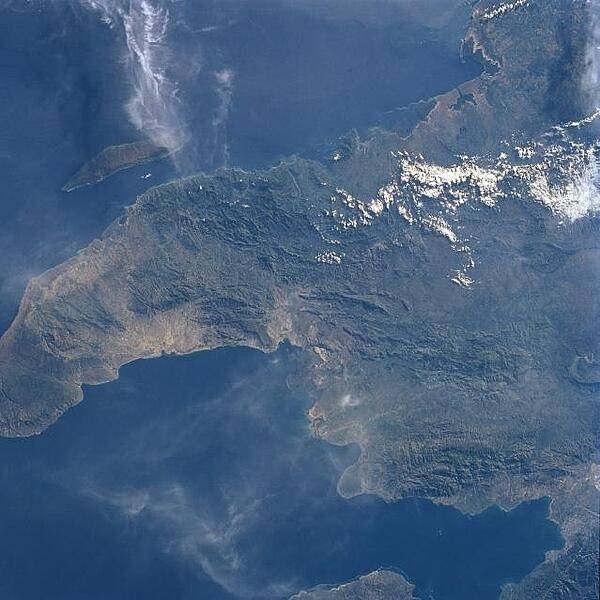
The northwest peninsula of Haiti and the Gulf of Gonave are visible in this northeast-looking view. The Gulf of Gonave is situated in the pincers of two mountainous peninsulas and is considered one of the most beautiful in the world. Image courtesy of NASA.
The northwest peninsula of Haiti and the Gulf of Gonave are visible in this northeast-looking view. The Gulf of Gonave is situated in the pincers of two mountainous peninsulas and is considered one of the most beautiful in the world. Image courtesy of NASA. • CIA World Factbook • 2020
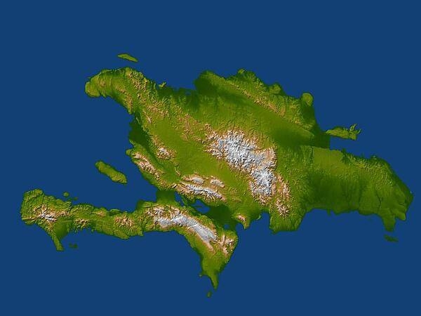
Satellite radar topographic view of the island of Hispaniola. The devastating earthquake at Port-au-Prince, Haiti, on 12 January 2010, occurred on the Enriquillo-Plantain Garden fault, visible here as a prominent linear landform immediately southwest of the city of Port-au-Prince and as a series of fault traces extending westward along the full length of the southern Tiburon Peninsula. Image courtesy of NASA/JPL/NGA.
Satellite radar topographic view of the island of Hispaniola. The devastating earthquake at Port-au-Prince, Haiti, on 12 January 2010, occurred on the Enriquillo-Plantain Garden fault, visible here as a prominent linear landform immediately southwest of the city of Port-au-Prince and as a series of fault traces extending westward along the full length of the southern Tiburon Peninsula. Image courtesy of NASA/JPL/NGA. • CIA World Factbook • 2020
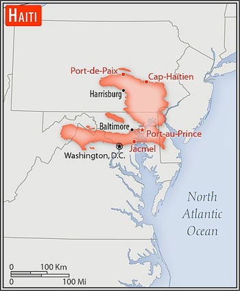
Area comparison map
Area comparison map • CIA World Factbook • 2020
4 photos available
Data sources: World Bank, UN Data • Updated daily •Learn about our data