›››
Isle of Man
Isle of Man
Population
84.2K
Rank #196Source: World Bank
Capital
Douglas
Source: REST Countries
Region
Europe
Europe & Central Asia
Source: REST Countries
GDP (Nominal)
$7.43B
Source: World Bank
Land Area
572 km²
Rank #187Source: REST Countries
Life Expectancy
80.999 yrs
Source: World Bank
Historical Trends
Population Trend (5-Year)
Source: World Bank
GDP Trend (5-Year, Nominal USD)
Source: World Bank
Geography
Area: 572 km²
Landlocked: No
Independent: No
Climate: temperate; cool summers and mild winters; overcast about a third of the time
Terrain: hills in north and south bisected by central valley
Elevation: lowest point: Irish Sea 0 m highest point: Snaefell 621 m
Natural Hazards: occasional high winds and rough seas
Environmental Issues: air pollution, marine pollution; waste disposal (both household and industrial)
Land Use: agricultural land: 74.7% (2011 est.) forest: 6.1% (2011 est.) other: 19.2% (2011 est.)
Geography Note: one small islet, the Calf of Man, lies to the southwest and is a bird sanctuary
Natural Resources
none
People & Society
Fertility Rate
1.55
Population
84.2K
Ethnic Groups
White (96.5%)Asian/Asian British (1.9%)other (1.5%)
Economy
GDP per Capita
$88,328.548
GDP per Capita PPP
Not Available
GNI per Capita
78,440
(2022)
(2022)
Gini Index
Not Available
Unemployment
Not Available
Inflation
Not Available
Public Debt
Not Available
Energy
Electricity Access
100%
(2023)
(2023)
Renewable Energy
2.7%
(2022)
(2022)
CO₂ Emissions
Not Available
Energy Intensity
Not Available
Renewable Electricity
Not Available
Environment
Forest Coverage
6.07% of land
(2023)
(2023)
Health
Physicians per 1,000
Not Available
Safe Water Access
100%
(2024)
(2024)
Safe Drinking Water
99.911%
(2024)
(2024)
Under-5 Mortality
Not Available
Maternal Mortality (World Bank)
Not Available
Governance
Women in Government
Not Available
Voice & Accountability
Not Available
Political Stability
Not Available
Government Effectiveness
Not Available
Regulatory Quality
Not Available
Rule of Law
Not Available
Control of Corruption
Not Available
Government
Government Type
parliamentary democracy (Tynwald)
Legal System
the laws of the UK apply where applicable and include Manx statutes
Executive Branch
chief of state: Lord of Mann Queen ELIZABETH II (since 6 February 1952); represented by Lieutenant Governor Sir Richard GOZNEY (since 27 May 2016) head of government: Chief Minister Howard QUAYLE...
Legislative Branch
description: bicameral Tynwald or the High Court of Tynwald consists of:Legislative Council (11 seats; includes the President of Tynwald, 2 ex-officio members - the Lord Bishop of Sodor and Man and...
Judicial Branch
highest courts: Isle of Man High Court of Justice (consists of 3 permanent judges or "deemsters" and 1 judge of appeal; organized into the Staff of Government Division or Court of Appeal and the...
International Organizations
National Symbols
Flag Description
red with the Three Legs of Man emblem (triskelion), in the center; the three legs are joined at the thigh and bent at the knee; in order to have the toes pointing clockwise on both sides of the flag,...
National Symbols
triskelion (a motif of three legs); national colors: red, white
National Anthem
name: "Arrane Ashoonagh dy Vannin" (O Land of Our Birth) lyrics/music: William Henry GILL [English], John J. KNEEN [Manx]/traditional note: adopted 2003, in use since 1907; serves as a local anthem;...
Safety
Homicide Rate
1.196 per 100,000
(2015)
(2015)
Travel Information
Language(s): English, Manx
Currency: GBP (£), IMP (£)
Timezone(s): UTC+00:00
Landlocked: No
Independent: No
Driving Side: Left
Calling Code: +44
Car Sign: GBM
Week Starts: Monday
Photos
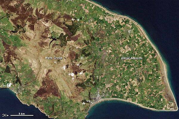
The Isle of Man is a small island with a complex geologic history. Geologists have studied and reported on the Isle of Man since the 19th century, making it a popular destination for rock hounds. Roughly 50 km (30 mi) from northeast to southwest, the island preserves rock layers dating back hundreds of millions of years. While most of the rocks are covered by soil, some rock layers exposed at the surface, along the coast, and in quarries have shed light on this island's assorted ancient landscapes. This natural-color satellite image of the Isle from 1 May 2001 shows the northern end of the island; the image has been rotated so north is to the right. Croplands cover the relatively flat terrain of the northern coastal plain, which forms a rough triangle. Underlying the fields are glacial sediments. Between 70,000 and 10,000 years ago, a giant ice sheet covered the Isle of Man. The ice advanced and retreated multiple times, occasionally piling up rocks to form hills. As the ice melted, all the dirt and debris locked within it came to rest on the northern plain. Toward the south, the land rises. The rock layers in this region are collectively known as the Manx Group; they make up the bulk of the Isle of Man, and comprise a mixture of sedimentary and volcanic rocks, folded and faulted by millions of years of tectonic pressures. They are far older than the glacial sediments coating the northern plain, having been formed between 490 million and 470 million years ago at the bottom of an ancient sea floor. Visible from the sky, the uneven contours of these rock layers hint at their complicated history. Photo courtesy of NASA.
The Isle of Man is a small island with a complex geologic history. Geologists have studied and reported on the Isle of Man since the 19th century, making it a popular destination for rock hounds. Roughly 50 km (30 mi) from northeast to southwest, the island preserves rock layers dating back hundreds of millions of years. While most of the rocks are covered by soil, some rock layers exposed at the surface, along the coast, and in quarries have shed light on this island's assorted ancient landscapes.
This natural-color satellite image of the Isle from 1 May 2001 shows the northern end of the island; the image has been rotated so north is to the right. Croplands cover the relatively flat terrain of the northern coastal plain, which forms a rough triangle. Underlying the fields are glacial sediments. Between 70,000 and 10,000 years ago, a giant ice sheet covered the Isle of Man. The ice advanced and retreated multiple times, occasionally piling up rocks to form hills. As the ice melted, all the dirt and debris locked within it came to rest on the northern plain.
Toward the south, the land rises. The rock layers in this region are collectively known as the Manx Group; they make up the bulk of the Isle of Man, and comprise a mixture of sedimentary and volcanic rocks, folded and faulted by millions of years of tectonic pressures. They are far older than the glacial sediments coating the northern plain, having been formed between 490 million and 470 million years ago at the bottom of an ancient sea floor. Visible from the sky, the uneven contours of these rock layers hint at their complicated history. Photo courtesy of NASA. • CIA World Factbook • 2020
CIA World Factbook • 2020
CIA World Factbook • 2020
3 photos available
Data sources: World Bank, UN Data • Updated daily •Learn about our data