›››
Iran, Islamic Rep.
Iran, Islamic Rep.
Population
91.6M
Rank #17Source: World Bank
Capital
Tehran
Source: REST Countries
Region
Africa
Middle East, North Africa, Afghanistan & Pakistan
Source: REST Countries
GDP (Nominal)
$475.25B
Rank #33Source: World Bank
Land Area
1.6M km²
Rank #18Source: REST Countries
Life Expectancy
77.654 yrs
Source: World Bank
Historical Trends
Population Trend (5-Year)
Source: World Bank
GDP Trend (5-Year, Nominal USD)
Source: World Bank
Geography
Area: 1,648,195 km²
Landlocked: No
Independent: Yes
Climate: mostly arid or semiarid, subtropical along Caspian coast
Terrain: rugged, mountainous rim; high, central basin with deserts, mountains; small, discontinuous plains along both coasts
Elevation: mean elevation: 1,305 m lowest point: Caspian Sea -28 m highest point: Kuh-e Damavand 5,625 m
Natural Hazards: periodic droughts, floods; dust storms, sandstorms; earthquakes
Environmental Issues: air pollution, especially in urban areas, from vehicle emissions, refinery operations, and industrial effluents; deforestation; overgrazing; desertification; oil pollution in the Persian Gulf;...
Land Use: agricultural land: 30.1% (2011 est.) forest: 6.8% (2011 est.) other: 63.1% (2011 est.)
Geography Note: strategic location on the Persian Gulf and Strait of Hormuz, which are vital maritime pathways for crude oil transport
Natural Resources
petroleumnatural gascoalchromiumcopperiron oreleadmanganesezincsulfur
People & Society
Fertility Rate
1.70
Population
91.6M
Religions
Muslim (official) (99.4%)other (includes Zoroastrian, Jewish, and Christian) (0.3%)unspecified (0.4%)
Economy
GDP per Capita
$5,190.17
GDP per Capita PPP
19,873.886
(2024)
(2024)
GNI per Capita
5,130
(2024)
(2024)
Gini Index
35.9
(2023)
(2023)
Unemployment
8.146%
(2024)
(2024)
Inflation
32.456%
(2024)
(2024)
Public Debt
Not Available
Energy
Electricity Access
100%
(2023)
(2023)
Renewable Energy
0.9%
(2021)
(2021)
CO₂ Emissions
828.99 Mt
(2024)
(2024)
Energy Intensity
9.32 MJ/$
(2021)
(2021)
Renewable Electricity
4.238%
(2021)
(2021)
Environment
Forest Coverage
6.649% of land
(2023)
(2023)
Protected Areas
7.3% of land
(2005)
(2005)
Communications
Internet Users
79.631%
(2023)
(2023)
Mobile Penetration
166.28%
(2023)
(2023)
Broadband Subscribers
12.021%
(2023)
(2023)
Transportation
Air Transport Freight
136.931 M ton-km
(2023)
(2023)
Container Port Traffic
1,550,304 TEU
(2021)
(2021)
Airports
144,976
Rail Lines
9,455 km
Roads Total
221,053 km(©IRF)
Military
Military Forces
Islamic Republic of Iran Regular Forces (Artesh): Ground Forces, Navy (includes marines), Air Force, Air Defense Forces; Islamic Revolutionary Guard Corps (Sepah, IRGC): Ground Forces, Navy (includes...
Personnel Strength
assessments of the size of the armed forces of Iran vary; approximately 600,000 total active personnel including 410,000 Islamic Republic of Iran Regular Forces (350,000 Ground Forces; 18,000 Navy;...
Military Expenditure (USD)
$7.89B
Military Expenditure (% of GDP)
2.01%
Military Expenditure History
3.8% of GDP (2019 est.) 6.1% of GDP (2018) 5.3% of GDP (2017 est.) 4.1% of GDP (2016 est.) 4.3% of GDP (2015 est.)
Deployments
est. 1,000 Syria (2020) note: Iran has recruited, trained, and funded thousands of Syrian and foreign fighters to support the ASAD regime during the Syrian civil war
Equipment & Inventories
the Iranian military's inventory includes a mix of domestically-produced and mostly older foreign equipment largely of Chinese, Russian, Soviet, and US origin (US equipment acquired prior to the...
Service Age & Obligation
18 years of age for compulsory military service; 16 years of age for volunteers; 17 years of age for Law Enforcement Forces; 15 years of age for Basij Forces (Popular Mobilization Army); conscript...
Education
Pre-Primary Enrollment
72.477%
(2020)
(2020)
Primary Enrollment
104.68%
(2020)
(2020)
Secondary Enrollment
85.191%
(2020)
(2020)
Tertiary Enrollment
58.668%
(2022)
(2022)
Education Spending
2.824% of GDP
(2023)
(2023)
Adult Literacy Rate
88.923%
(2023)
(2023)
Pupil-Teacher Ratio
28.525:1
(2017)
(2017)
Health
Physicians per 1,000
1.811
(2023)
(2023)
Safe Water Access
97.852%
(2024)
(2024)
Safe Drinking Water
94.412%
(2024)
(2024)
Under-5 Mortality
11.8 per 1,000
(2023)
(2023)
Maternal Mortality (World Bank)
19.214 per 100,000
(2021)
(2021)
Hospital Beds per 1,000
76.401
(2021)
(2021)
UHC Coverage Index
81
(2023)
(2023)
Measles Immunization
98%
(2024)
(2024)
Social Indicators
Extreme Poverty Rate
2.5%
(2023)
(2023)
Food Insecurity
6.8%
(2023)
(2023)
Youth NEET Rate
20.158%
(2024)
(2024)
Governance
Women in Government
4.828%
(2024)
(2024)
Voice & Accountability
-1.45
(Weak)
(2023)
(Weak)
(2023)
Political Stability
-1.69
(Weak)
(2023)
(Weak)
(2023)
Government Effectiveness
-1.02
(Weak)
(2023)
(Weak)
(2023)
Regulatory Quality
-1.69
(Weak)
(2023)
(Weak)
(2023)
Rule of Law
-1.06
(Weak)
(2023)
(Weak)
(2023)
Control of Corruption
-1.23
(Weak)
(2023)
(Weak)
(2023)
Government
Government Type
theocratic republic
Legal System
religious legal system based on secular and Islamic law
Executive Branch
chief of state: Supreme Leader Ali Hoseini-KHAMENEI (since 4 June 1989) head of government: President Hasan Fereidun ROHANI (since 3 August 2013); First Vice President Eshagh JAHANGIRI (since 5...
Legislative Branch
description: unicameral Islamic Consultative Assembly or Majles-e Shura-ye Eslami or Majles (290 seats; 285 members directly elected in single- and multi-seat constituencies by 2-round vote, and 1...
Judicial Branch
highest courts: Supreme Court (consists of the chief justice and organized into 42 two-bench branches, each with a justice and a judge) judge selection and term of office: Supreme Court president...
National Symbols
Flag Description
three equal horizontal bands of green (top), white, and red; the national emblem (a stylized representation of the word Allah in the shape of a tulip, a symbol of martyrdom) in red is centered in the...
National Symbols
lion; national colors: green, white, red
National Anthem
name: "Soroud-e Melli-ye Jomhouri-ye Eslami-ye Iran" (National Anthem of the Islamic Republic of Iran) lyrics/music: multiple authors/Hassan RIAHI note 1: adopted 1990; Iran has had six national...
Safety
Homicide Rate
2.375 per 100,000
(2014)
(2014)
Travel Information
Language(s): Persian (Farsi)
Currency: IRR (﷼)
Timezone(s): UTC+03:30
Landlocked: No
Independent: Yes
Driving Side: Right
Calling Code: +98
Car Sign: IR
Week Starts: Saturday
Photos
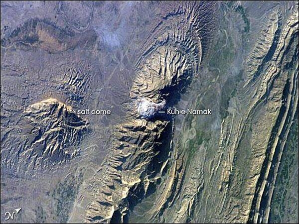
The Zagros Mountains in southwestern Iran present an impressive landscape of long linear ridges and valleys. Formed by collision of the Eurasian and Arabian tectonic plates, the ridges and valleys extend hundreds of kilometers. This astronaut photograph of the southwestern edge of the Zagros mountain belt includes another common feature of the region - a salt dome (Kuh-e-Namak or "mountain of salt" in Farsi). Thick layers of minerals such as halite (table salt) typically accumulate in closed basins during alternating wet and dry climatic conditions. Over geologic time, these layers of salt are buried under younger layers of rock. The pressure from overlying rock layers causes the lower-density salt to flow upwards, bending the overlying rock layers and creating a dome-like structure. Erosion has spectacularly revealed the uplifted tan and brown rock layers surrounding the white Kuh-e-Namak to the northwest and southeast (center of image). Radial drainage patterns indicate another salt dome is located to the southwest (image left center). If the rising plug of salt (called a salt diapir) breaches the surface, it can become a flowing salt glacier. Salt domes are an important target for oil exploration, as the impermeable salt frequently traps petroleum beneath other rock layers. Image courtesy of NASA.
The Zagros Mountains in southwestern Iran present an impressive landscape of long linear ridges and valleys. Formed by collision of the Eurasian and Arabian tectonic plates, the ridges and valleys extend hundreds of kilometers. This astronaut photograph of the southwestern edge of the Zagros mountain belt includes another common feature of the region - a salt dome (Kuh-e-Namak or "mountain of salt" in Farsi). Thick layers of minerals such as halite (table salt) typically accumulate in closed basins during alternating wet and dry climatic conditions. Over geologic time, these layers of salt are buried under younger layers of rock. The pressure from overlying rock layers causes the lower-density salt to flow upwards, bending the overlying rock layers and creating a dome-like structure. Erosion has spectacularly revealed the uplifted tan and brown rock layers surrounding the white Kuh-e-Namak to the northwest and southeast (center of image). Radial drainage patterns indicate another salt dome is located to the southwest (image left center). If the rising plug of salt (called a salt diapir) breaches the surface, it can become a flowing salt glacier. Salt domes are an important target for oil exploration, as the impermeable salt frequently traps petroleum beneath other rock layers. Image courtesy of NASA. • CIA World Factbook • 2020
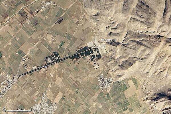
In southwestern Iran, roughly 650 km (400 mi) south of the capital city of Tehran, and some 70 km (40 mi) northeast of Shiraz, a cultivated plain gives way to the Zagros Mountains. At the transition between flat land and rugged mountain, at the base of Kuh-i-Rahmat, or "Mountain of Mercy," lies Persepolis. Founded around 518 B.C. by Darius the Great, the site served as the ceremonial capital of the Achaemenid (or Persian) Empire. Image courtesy of NASA.
In southwestern Iran, roughly 650 km (400 mi) south of the capital city of Tehran, and some 70 km (40 mi) northeast of Shiraz, a cultivated plain gives way to the Zagros Mountains. At the transition between flat land and rugged mountain, at the base of Kuh-i-Rahmat, or "Mountain of Mercy," lies Persepolis. Founded around 518 B.C. by Darius the Great, the site served as the ceremonial capital of the Achaemenid (or Persian) Empire. Image courtesy of NASA. • CIA World Factbook • 2020
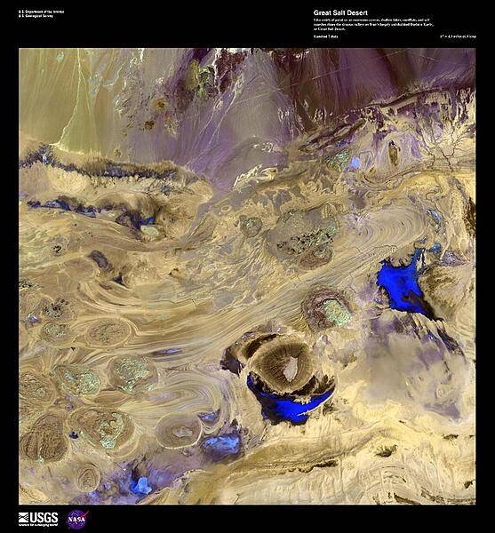
In this enhanced false-color satellite photo, shallow lakes, mudflats, and salt marshes share the sinuous valleys on Iran's largely uninhabited Dasht-e Kavir, or Great Salt Desert. Due to the high heat and arid climate, marshes, lakes, and wadis experience an extreme rate of groundwater evaporation leaving large crusts of salt. Image courtesy of USGS.
In this enhanced false-color satellite photo, shallow lakes, mudflats, and salt marshes share the sinuous valleys on Iran's largely uninhabited Dasht-e Kavir, or Great Salt Desert. Due to the high heat and arid climate, marshes, lakes, and wadis experience an extreme rate of groundwater evaporation leaving large crusts of salt. Image courtesy of USGS. • CIA World Factbook • 2020
Area comparison map
Area comparison map • CIA World Factbook • 2020
4 photos available
Data sources: World Bank, UN Data • Updated daily •Learn about our data