›››
Comoros
Comoros
Population
866.6K
Rank #162Source: World Bank
Capital
Moroni
Source: REST Countries
Region
Africa
Sub-Saharan Africa
Source: REST Countries
GDP (Nominal)
$1.44B
Rank #181Source: World Bank
Land Area
1.9K km²
Rank #175Source: REST Countries
Life Expectancy
66.777 yrs
Source: World Bank
Historical Trends
Population Trend (5-Year)
Source: World Bank
GDP Trend (5-Year, Nominal USD)
Source: World Bank
Geography
Area: 1,862 km²
Landlocked: No
Independent: Yes
Climate: tropical marine; rainy season (November to May)
Terrain: volcanic islands, interiors vary from steep mountains to low hills
Elevation: lowest point: Indian Ocean 0 m highest point: Karthala 2,360 m
Natural Hazards: cyclones possible during rainy season (December to April); volcanic activity on Grand Comorevolcanism: Karthala (2,361 m) on Grand Comore Island last erupted in 2007; a 2005 eruption forced thousands...
Environmental Issues: deforestation; soil degradation and erosion results from forest loss and from crop cultivation on slopes without proper terracing; marine biodiversity affected as soil erosion leads to the silting of...
Land Use: agricultural land: 84.4% (2011 est.) forest: 1.4% (2011 est.) other: 14.2% (2011 est.)
Geography Note: important location at northern end of Mozambique Channel
Natural Resources
fish
People & Society
Fertility Rate
3.88
Population
866.6K
Religions
Sunni Muslim (98%)other (including Shia Muslim, Roman Catholic, Jehovah's Witness, Protestant) (2%)
Economy
GDP per Capita
$1,662.757
GDP per Capita PPP
3,958.532
(2024)
(2024)
GNI per Capita
1,590
(2024)
(2024)
Gini Index
45.3
(2014)
(2014)
Unemployment
3.815%
(2024)
(2024)
Inflation
5.052%
(2024)
(2024)
Public Debt
Not Available
Energy
Electricity Access
89.8%
(2023)
(2023)
Renewable Energy
39.3%
(2022)
(2022)
CO₂ Emissions
0.446 Mt
(2024)
(2024)
Energy Intensity
4.3 MJ/$
(2022)
(2022)
Renewable Electricity
Not Available
Environment
Forest Coverage
16.98% of land
(2023)
(2023)
Communications
Internet Users
35.668%
(2023)
(2023)
Mobile Penetration
109.856%
(2023)
(2023)
Broadband Subscribers
0.388%
(2023)
(2023)
Transportation
Air Transport Freight
Not Available
Container Port Traffic
54,358.54 TEU
(2019)
(2019)
Airports
N/A
Rail Lines
N/A
Roads Total
N/A
Military
Military Forces
National Army for Development (l'Armee Nationale de Developpement, AND): Comoran Security Force (also called Comoran Defense Force (Force Comorienne de Defense, FCD), includes Gendarmerie), Comoran...
Service Age & Obligation
18 years of age for 2-year voluntary male and female military service; no conscription
Education
Pre-Primary Enrollment
21.808%
(2018)
(2018)
Primary Enrollment
97.005%
(2024)
(2024)
Secondary Enrollment
61.701%
(2018)
(2018)
Tertiary Enrollment
18.819%
(2017)
(2017)
Education Spending
2.341% of GDP
(2023)
(2023)
Adult Literacy Rate
75.825%
(2021)
(2021)
Pupil-Teacher Ratio
28.058:1
(2018)
(2018)
Health
Physicians per 1,000
0.424
(2022)
(2022)
Safe Water Access
85.054%
(2024)
(2024)
Safe Drinking Water
Not Available
Under-5 Mortality
39.8 per 1,000
(2023)
(2023)
Maternal Mortality (World Bank)
17.178 per 100,000
(2021)
(2021)
Hospital Beds per 1,000
68.728
(2021)
(2021)
UHC Coverage Index
52
(2023)
(2023)
Measles Immunization
75%
(2024)
(2024)
Social Indicators
Extreme Poverty Rate
31.4%
(2014)
(2014)
Food Insecurity
15.4%
(2023)
(2023)
Youth NEET Rate
9.797%
(2021)
(2021)
Governance
Women in Government
16.667%
(2024)
(2024)
Voice & Accountability
-0.81
(Below Average)
(2023)
(Below Average)
(2023)
Political Stability
-0.23
(Below Average)
(2023)
(Below Average)
(2023)
Government Effectiveness
-1.53
(Weak)
(2023)
(Weak)
(2023)
Regulatory Quality
-1.24
(Weak)
(2023)
(Weak)
(2023)
Rule of Law
-1.34
(Weak)
(2023)
(Weak)
(2023)
Control of Corruption
-0.99
(Below Average)
(2023)
(Below Average)
(2023)
Government
Government Type
federal presidential republic
Legal System
mixed legal system of Islamic religious law, the French civil code of 1975, and customary law
Executive Branch
chief of state: President AZALI Assoumani (since 26 May 2016); note - the president is both chief of state and head of government; note - AZALI takes oath of office 2 June 2019 after 24 March 2019...
Legislative Branch
description: unicameral Assembly of the Union (33 seats; 24 members directly elected by absolute majority vote in 2 rounds if needed and 9 members indirectly elected by the 3 island assemblies;...
Judicial Branch
highest courts: Supreme Court or Cour Supreme (consists of 7 judges) judge selection and term of office: Supreme Court judges - selection and term of office NA subordinate courts: Court of Appeals...
National Symbols
Flag Description
four equal horizontal bands of yellow (top), white, red, and blue, with a green isosceles triangle based on the hoist; centered within the triangle is a vertical white crescent moon with the convex...
National Symbols
four five-pointed stars and crescent moon; national colors: green, white
National Anthem
name: "Udzima wa ya Masiwa" (The Union of the Great Islands) lyrics/music: Said Hachim SIDI ABDEREMANE/Said Hachim SIDI ABDEREMANE and Kamildine ABDALLAH note: adopted 1978
Travel Information
Language(s): Arabic, French, Comorian
Currency: KMF (Fr)
Timezone(s): UTC+03:00
Landlocked: No
Independent: Yes
Driving Side: Right
Calling Code: +269
Car Sign: COM
Week Starts: Monday
Photos
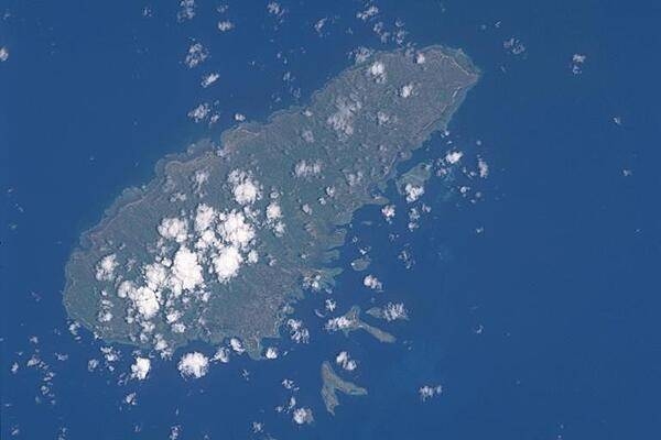
A close-up satellite view of Moheli, the smallest of Comoros' three main islands. Photo courtesy of NASA.
A close-up satellite view of Moheli, the smallest of Comoros' three main islands. Photo courtesy of NASA. • CIA World Factbook • 2020
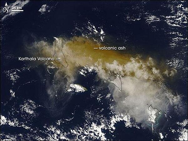
On 24 November 2005, some 2,000 people fled their homes hoping to escape the latest eruption of the Karthala Volcano. The volcano covered nearby villages in ash and locals had little means of protecting their lungs beyond covering their faces with scarves. Karthala is one of two volcanoes that make up Grande Comore (or N'gazidja) Island in the Comoros archipelago. These islands lie in the Indian Ocean, between Africa and Madagascar. In this image of 25 November 2005, Grande Comore appears only in outline as material from the eruption completely obscures the satellite's view of the land surface. The volcanic ash ranges in color from tan to beige; it has spread out around the volcano in all directions, but moves primarily eastward. With an altitude of 2,361 m (7,746 ft), Karthala is a shield volcano, with smooth slopes built from hardened lava. Comprising the southern portion of Grande Comore Island, Karthala is a regular troublemaker in its neighborhood. The volcano has erupted about 20 times in the last century. Photo courtesy of NASA.
On 24 November 2005, some 2,000 people fled their homes hoping to escape the latest eruption of the Karthala Volcano. The volcano covered nearby villages in ash and locals had little means of protecting their lungs beyond covering their faces with scarves.
Karthala is one of two volcanoes that make up Grande Comore (or N'gazidja) Island in the Comoros archipelago. These islands lie in the Indian Ocean, between Africa and Madagascar. In this image of 25 November 2005, Grande Comore appears only in outline as material from the eruption completely obscures the satellite's view of the land surface. The volcanic ash ranges in color from tan to beige; it has spread out around the volcano in all directions, but moves primarily eastward.
With an altitude of 2,361 m (7,746 ft), Karthala is a shield volcano, with smooth slopes built from hardened lava. Comprising the southern portion of Grande Comore Island, Karthala is a regular troublemaker in its neighborhood. The volcano has erupted about 20 times in the last century. Photo courtesy of NASA. • CIA World Factbook • 2020
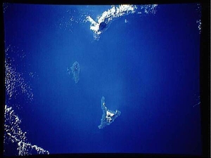
All three main islands of the Comoros archipelago are visible in this satellite image: Grande Comore (top), Moheli (middle), and Anjouan (bottom). Photo courtesy of NASA.
All three main islands of the Comoros archipelago are visible in this satellite image: Grande Comore (top), Moheli (middle), and Anjouan (bottom). Photo courtesy of NASA. • CIA World Factbook • 2020
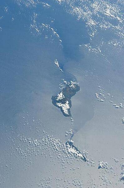
Grande Comore appears in the center of this view with Moheli (mostly cloud covered) toward the bottom. The silvery surface of the Mozambique Channel is due to sun glint. Photo courtesy of NASA.
Grande Comore appears in the center of this view with Moheli (mostly cloud covered) toward the bottom. The silvery surface of the Mozambique Channel is due to sun glint. Photo courtesy of NASA. • CIA World Factbook • 2020
4 photos available
Data sources: World Bank, UN Data • Updated daily •Learn about our data