›››
Lebanon
Lebanon
Population
5.8M
Rank #115Source: World Bank
Capital
Beirut
Source: REST Countries
Region
Africa
Middle East, North Africa, Afghanistan & Pakistan
Source: REST Countries
GDP (Nominal)
$20.08B
Source: World Bank
Land Area
10.5K km²
Rank #164Source: REST Countries
Life Expectancy
77.817 yrs
Source: World Bank
Historical Trends
Population Trend (5-Year)
Source: World Bank
GDP Trend (5-Year, Nominal USD)
Source: World Bank
Geography
Area: 10,452 km²
Landlocked: No
Independent: Yes
Climate: Mediterranean; mild to cool, wet winters with hot, dry summers; the Lebanon Mountains experience heavy winter snows
Terrain: narrow coastal plain; El Beqaa (Bekaa Valley) separates Lebanon and Anti-Lebanon Mountains
Elevation: mean elevation: 1,250 m lowest point: Mediterranean Sea 0 m highest point: Qornet es Saouda 3,088 m
Natural Hazards: earthquakes; dust storms, sandstorms
Environmental Issues: deforestation; soil deterioration, erosion; desertification; species loss; air pollution in Beirut from vehicular traffic and the burning of industrial wastes; pollution of coastal waters from raw...
Land Use: agricultural land: 63.3% (2011 est.) forest: 13.4% (2011 est.) other: 23.3% (2011 est.)
Geography Note: smallest country in continental Asia; Nahr el Litani is the only major river in Near East not crossing an international boundary; rugged terrain historically helped isolate, protect, and develop...
Natural Resources
limestoneiron oresaltwater-surplus state in a water-deficit regionarable land
People & Society
Fertility Rate
2.24
Population
5.8M
Ethnic Groups
Arab (95%)Armenian (4%)other (1%)
Religions
Muslim (61.1%)Christian (33.7%)Druze (5.2%)
Economy
GDP per Capita
$3,477.725
GDP per Capita PPP
12,574.833
(2023)
(2023)
GNI per Capita
3,700
(2023)
(2023)
Gini Index
35.3
(2022)
(2022)
Unemployment
10.985%
(2023)
(2023)
Inflation
45.243%
(2024)
(2024)
Public Debt
Not Available
Energy
Electricity Access
100%
(2023)
(2023)
Renewable Energy
6.8%
(2021)
(2021)
CO₂ Emissions
11.004 Mt
(2024)
(2024)
Energy Intensity
3.55 MJ/$
(2021)
(2021)
Renewable Electricity
5.072%
(2021)
(2021)
Environment
Forest Coverage
14.187% of land
(2023)
(2023)
Protected Areas
2% of land
(2000)
(2000)
Communications
Internet Users
83.493%
(2023)
(2023)
Mobile Penetration
74.015%
(2022)
(2022)
Broadband Subscribers
7.292%
(2022)
(2022)
Transportation
Air Transport Freight
34.396 M ton-km
(2023)
(2023)
Container Port Traffic
675,077 TEU
(2021)
(2021)
Airports
23,751
Rail Lines
N/A
Roads Total
7,000 km(©IRF)
Military
Military Forces
Lebanese Armed Forces (LAF): Army Command (includes Presidential Guard Brigade, Land Border Regiments), Naval Forces, Air Forces; Lebanese Internal Security Forces Directorate (includes Mobile...
Personnel Strength
the Lebanese Armed Forces (LAF) have approximately 58,000 active troops (55,000 Army; 1,500 Navy; 1,500 AF); est. 20,000 Internal Security Forces
Military Expenditure (USD)
$0.64B
Military Expenditure (% of GDP)
2.59%
Military Expenditure History
4.2% of GDP (2019) 4.9% of GDP (2018) 4.5% of GDP (2017) 5.1% of GDP (2016) 4.5% of GDP (2015)
Equipment & Inventories
the LAF inventory includes a wide mix of mostly older equipment, largely from the US and European countries, particularly France and Germany; since 2010, the US is the leading supplier of armaments...
Service Age & Obligation
17-25 years of age for voluntary military service (including women); no conscription
Education
Pre-Primary Enrollment
Not Available
Primary Enrollment
81.769%
(2024)
(2024)
Secondary Enrollment
63.792%
(2024)
(2024)
Tertiary Enrollment
54.401%
(2023)
(2023)
Education Spending
1.225% of GDP
(2024)
(2024)
Adult Literacy Rate
92.014%
(2019)
(2019)
Pupil-Teacher Ratio
12.483:1
(2017)
(2017)
Health
Physicians per 1,000
2.68
(2020)
(2020)
Safe Water Access
92.6%
(2024)
(2024)
Safe Drinking Water
47.7%
(2024)
(2024)
Under-5 Mortality
18.3 per 1,000
(2023)
(2023)
Maternal Mortality (World Bank)
21.495 per 100,000
(2021)
(2021)
Hospital Beds per 1,000
74.342
(2021)
(2021)
UHC Coverage Index
67
(2023)
(2023)
Measles Immunization
49%
(2024)
(2024)
Social Indicators
Extreme Poverty Rate
5.9%
(2022)
(2022)
Food Insecurity
8.7%
(2023)
(2023)
Youth NEET Rate
23.316%
(2019)
(2019)
Governance
Women in Government
6.25%
(2024)
(2024)
Voice & Accountability
-0.65
(Below Average)
(2023)
(Below Average)
(2023)
Political Stability
-1.52
(Weak)
(2023)
(Weak)
(2023)
Government Effectiveness
-1.58
(Weak)
(2023)
(Weak)
(2023)
Regulatory Quality
-1.01
(Weak)
(2023)
(Weak)
(2023)
Rule of Law
-1.17
(Weak)
(2023)
(Weak)
(2023)
Control of Corruption
-1.23
(Weak)
(2023)
(Weak)
(2023)
Government
Government Type
parliamentary republic
Legal System
mixed legal system of civil law based on the French civil code, Ottoman legal tradition, and religious laws covering personal status, marriage, divorce, and other family relations of the Jewish,...
Executive Branch
chief of state: President Michel AWN (since 31 October 2016) head of government: Prime Minister Saad HARIRI (since 22 October 2020) cabinet: Cabinet chosen by the prime minister in consultation with...
Legislative Branch
description: unicameral National Assembly or Majlis al-Nuwab in Arabic or Assemblee Nationale in French (128 seats; members directly elected by listed-based proportional representation vote; members...
Judicial Branch
highest courts: Court of Cassation or Supreme Court (organized into 8 chambers, each with a presiding judge and 2 associate judges); Constitutional Council (consists of 10 members) judge selection...
National Symbols
Flag Description
three horizontal bands consisting of red (top), white (middle, double width), and red (bottom) with a green cedar tree centered in the white band; the red bands symbolize blood shed for liberation,...
National Symbols
cedar tree; national colors: red, white, green
National Anthem
name: "Kulluna lil-watan" (All Of Us, For Our Country!) lyrics/music: Rachid NAKHLE/Wadih SABRA note: adopted 1927; chosen following a nationwide competition
Safety
Homicide Rate
2.245 per 100,000
(2020)
(2020)
Travel Information
Language(s): Arabic, French
Currency: LBP (ل.ل)
Timezone(s): UTC+02:00
Landlocked: No
Independent: Yes
Driving Side: Right
Calling Code: +961
Car Sign: RL
Week Starts: Monday
Photos
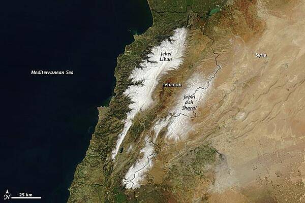
Bordering the eastern Mediterranean Sea, Lebanon might call to mind sunny beaches and historic port cities like Sidon and Tyre. However, the country is also home to towering, snowy mountains and ski resorts. In fact, the name Lebanon is derived from the Semitic word lbn, which means "white" in reference to either the snow-covered mountains or limestone cliffs. This satellite image highlights the country's two mountain ranges, Jebel Liban and Jabal ash Sharqim, covered in fresh snow. (Jebel or jabal mean "mountain" in Arabic.) Snow is not unusual in Lebanon, where ski resorts are open about three months of the year. Photo courtesy of NASA.
Bordering the eastern Mediterranean Sea, Lebanon might call to mind sunny beaches and historic port cities like Sidon and Tyre. However, the country is also home to towering, snowy mountains and ski resorts. In fact, the name Lebanon is derived from the Semitic word lbn, which means "white" in reference to either the snow-covered mountains or limestone cliffs. This satellite image highlights the country's two mountain ranges, Jebel Liban and Jabal ash Sharqim, covered in fresh snow. (Jebel or jabal mean "mountain" in Arabic.) Snow is not unusual in Lebanon, where ski resorts are open about three months of the year. Photo courtesy of NASA. • CIA World Factbook • 2020
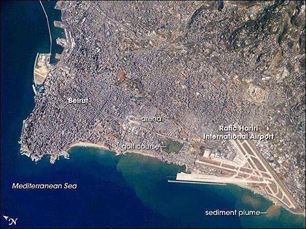
Beirut, Lebanon's capital, is built on a small peninsula; the growth of the city eastwards is bounded by foothills of the more mountainous interior of Lebanon (upper right). Beirut has been an urban center for 5,000 years. Throughout much of that time, the city has been the focus of both military and economic conflicts among neighboring city-states. Distinctive features visible in this astronaut photograph include the Rafic Hariri International Airport in the lower right, the city sports arena at image center, and several areas of green and open space, including a large golf course at image center. Also visible in the photo are several plumes of sediment along the coastline; the most striking plumes are near the airport. The general lack of vegetation in the airport may allow more soil transport by surface water runoff or wind. Photo courtesy of NASA.
Beirut, Lebanon's capital, is built on a small peninsula; the growth of the city eastwards is bounded by foothills of the more mountainous interior of Lebanon (upper right). Beirut has been an urban center for 5,000 years. Throughout much of that time, the city has been the focus of both military and economic conflicts among neighboring city-states. Distinctive features visible in this astronaut photograph include the Rafic Hariri International Airport in the lower right, the city sports arena at image center, and several areas of green and open space, including a large golf course at image center. Also visible in the photo are several plumes of sediment along the coastline; the most striking plumes are near the airport. The general lack of vegetation in the airport may allow more soil transport by surface water runoff or wind. Photo courtesy of NASA. • CIA World Factbook • 2020
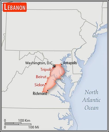
Area comparison map
Area comparison map • CIA World Factbook • 2020
3 photos available
Data sources: World Bank, UN Data • Updated daily •Learn about our data