›››
Morocco — Media Gallery
24 items available (flags, maps, photos)
Photos
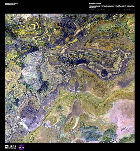
This enhanced satellite image shows the Anti-Atlas Mountains, part of the Atlas Mountain range in southern Morocco. The Anti-Atlas Mountains form a border between the Atlantic Ocean and the Sahara Desert, extending 500 km (310 mi) to their easternmost point, the 3,304 m (10,835 ft) peak of Djebel Sarho. The region contains some of the world's largest and most diverse mineral resources including phosphate rock, iron, zinc, copper, antimony, as well as gold and silver, most of which remain untouched. Image courtesy of USGS.
This enhanced satellite image shows the Anti-Atlas Mountains, part of the Atlas Mountain range in southern Morocco. The Anti-Atlas Mountains form a border between the Atlantic Ocean and the Sahara Desert, extending 500 km (310 mi) to their easternmost point, the 3,304 m (10,835 ft) peak of Djebel Sarho. The region contains some of the world's largest and most diverse mineral resources including phosphate rock, iron, zinc, copper, antimony, as well as gold and silver, most of which remain untouched. Image courtesy of USGS. • CIA World Factbook • 2020
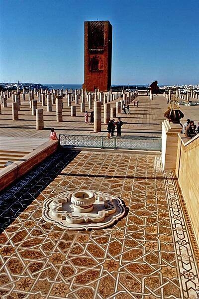
The Hassan Tower and the remains of a mosque that lie adjacent to the Mausoleum of Mohammed V in Rabat. The tower (44 m, 145 ft) is an incomplete minaret that was meant to be the the tallest in the world and to flank the world's largest mosque. Begun in 1195, construction was halted four years later when the sultan who commissioned the project died.
The Hassan Tower and the remains of a mosque that lie adjacent to the Mausoleum of Mohammed V in Rabat. The tower (44 m, 145 ft) is an incomplete minaret that was meant to be the the tallest in the world and to flank the world's largest mosque. Begun in 1195, construction was halted four years later when the sultan who commissioned the project died. • CIA World Factbook • 2020
CIA World Factbook • 2020
The Almoravid Qubba is a small monument in Marrakech. It was erected by the relatively short-lived Almoravid dynasty (1040-1147) in the early 12th century. It is notable for its extraordinary decoration and for being one of the only remnants of Almoravid architecture in Marrakech.
The Almoravid Qubba is a small monument in Marrakech. It was erected by the relatively short-lived Almoravid dynasty (1040-1147) in the early 12th century. It is notable for its extraordinary decoration and for being one of the only remnants of Almoravid architecture in Marrakech. • CIA World Factbook • 2020
The Caves of Hercules is an archaeological cave complex in Cape Spartel, 14 km west of Tangier. Atlantic Ocean waters flood the caves at high tide. The cave opening is said to resemble the shape of the continent of Africa.
The Caves of Hercules is an archaeological cave complex in Cape Spartel, 14 km west of Tangier. Atlantic Ocean waters flood the caves at high tide. The cave opening is said to resemble the shape of the continent of Africa. • CIA World Factbook • 2020
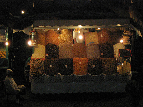
A night market vendor in Jemaa el-Fna - the main square in Marrakech - selling dried fruit and nuts.
A night market vendor in Jemaa el-Fna - the main square in Marrakech - selling dried fruit and nuts. • CIA World Factbook • 2020
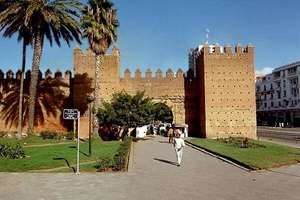
One of the walls of the medina (ancient city quarter) of Rabat. The Rabat medina dates back to the 17th century. It has a wide range of shops (pottery, leather, food), as well as parks, gardens, and broad boulevards.
One of the walls of the medina (ancient city quarter) of Rabat. The Rabat medina dates back to the 17th century. It has a wide range of shops (pottery, leather, food), as well as parks, gardens, and broad boulevards. • CIA World Factbook • 2020
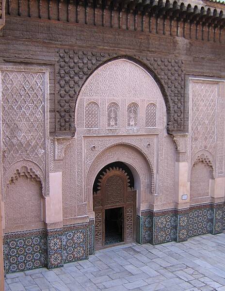
Today preserved as a historical site, the Ben Youssef Madrasa was founded in the 14th century and subsequently reconstructed. Upon completion in 1565, it became the largest Islamic college in Morocco and one of the largest in North Africa. The madrasa is named after the adjacent Ben Youssef Mosque founded by the Almoravid Sultan Ali ibn Yusuf (reigned 1106-1142).
Today preserved as a historical site, the Ben Youssef Madrasa was founded in the 14th century and subsequently reconstructed. Upon completion in 1565, it became the largest Islamic college in Morocco and one of the largest in North Africa. The madrasa is named after the adjacent Ben Youssef Mosque founded by the Almoravid Sultan Ali ibn Yusuf (reigned 1106-1142). • CIA World Factbook • 2020
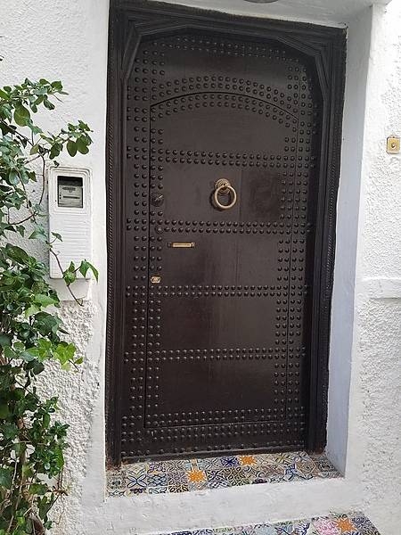
Decorated door in the Kasbah in Tangier.
Decorated door in the Kasbah in Tangier. • CIA World Factbook • 2020
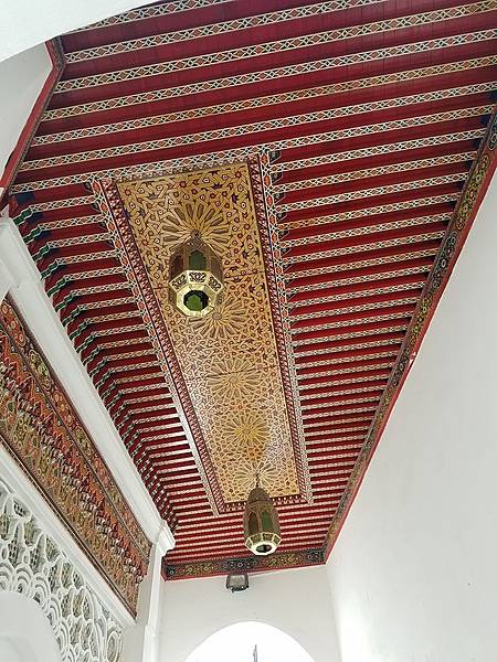
Decorated ceiling in the Kasbah in Tangier.
Decorated ceiling in the Kasbah in Tangier. • CIA World Factbook • 2020
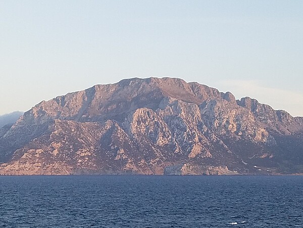
The coast of Morocco in the Gibraltar Straits.
The coast of Morocco in the Gibraltar Straits. • CIA World Factbook • 2020
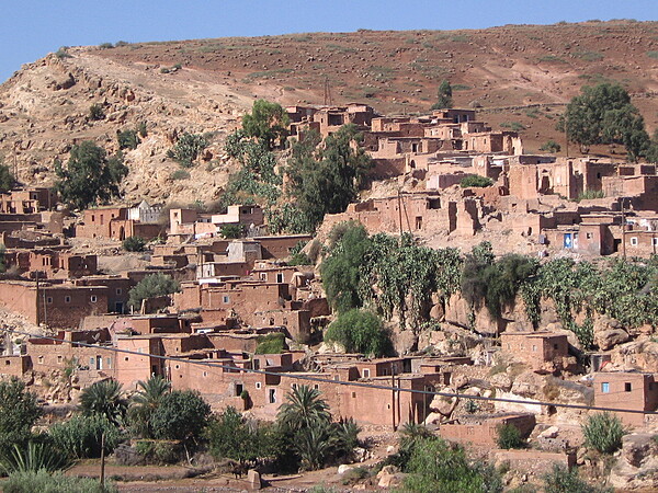
Village in the High Atlas Mountains of southern Morocco. The reddish (oxidized) soils lend their color to the brickwork throughout the village.
Village in the High Atlas Mountains of southern Morocco. The reddish (oxidized) soils lend their color to the brickwork throughout the village. • CIA World Factbook • 2020
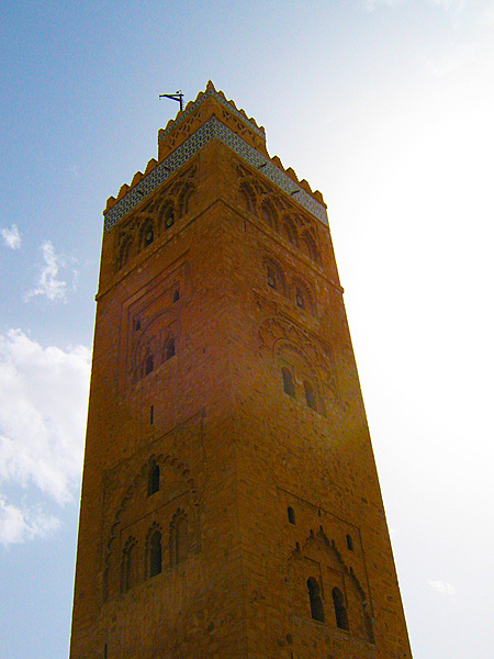
The Koutoubia Mosque minaret in Marrakech.
The Koutoubia Mosque minaret in Marrakech. • CIA World Factbook • 2020
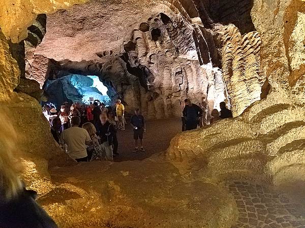
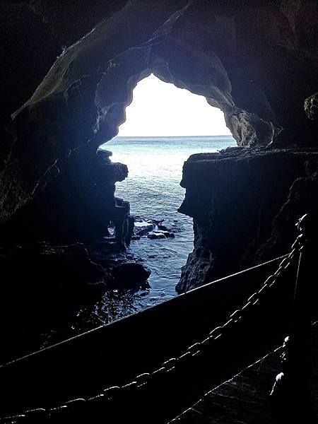
The interior of the Hercules Caves near Tangier. The Atlantic Ocean waters flood the caves at high tide.
The interior of the Hercules Caves near Tangier. The Atlantic Ocean waters flood the caves at high tide. • CIA World Factbook • 2020
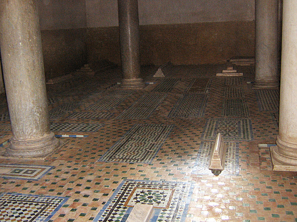
The Saadian Tombs are a historic royal necropolis in Marrakech that date to the time of the Saadian Dynasty (1549-1659). They are located on the south side of the Kasbah Mosque, inside the royal kasbah (citadel) district of the city. Because of the beauty of their decoration, the tombs have become a major attraction for visitors to Marrakech. This view offers a glimpse into the Chamber of the Three Niches from the main mausoleum.
The Saadian Tombs are a historic royal necropolis in Marrakech that date to the time of the Saadian Dynasty (1549-1659). They are located on the south side of the Kasbah Mosque, inside the royal kasbah (citadel) district of the city. Because of the beauty of their decoration, the tombs have become a major attraction for visitors to Marrakech. This view offers a glimpse into the Chamber of the Three Niches from the main mausoleum. • CIA World Factbook • 2020
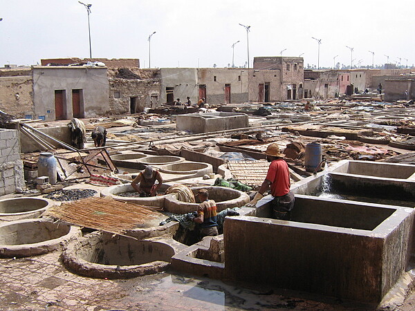
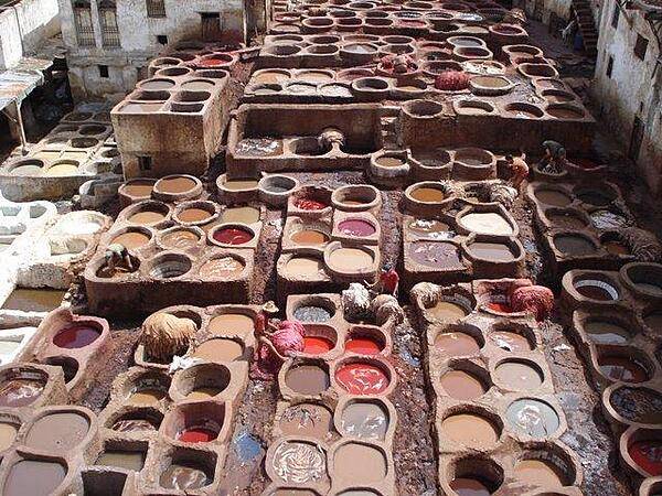
Marrakech tanneries.
Marrakech tanneries. • CIA World Factbook • 2020
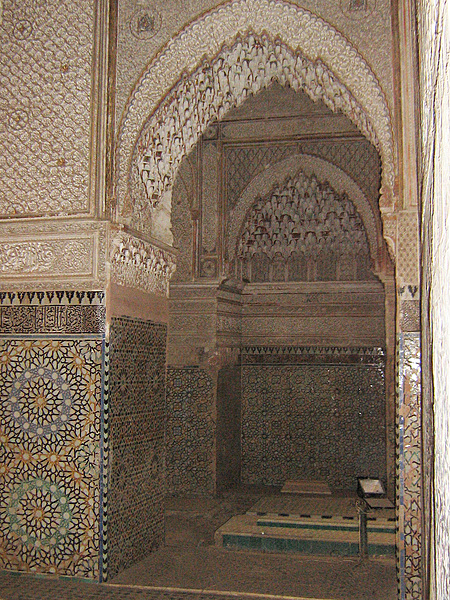
The Saadian Tombs are a historic royal necropolis in Marrakech that date to the time of the Saadian Dynasty (1549-1659). They are located on the south side of the Kasbah Mosque, inside the royal kasbah (citadel) district of the city. Because of the beauty of their decoration, the tombs have become a major attraction for visitors to Marrakech. This view is of the Chamber of the Mihrab in the larger mausoleum of the Saadian Tombs.
The Saadian Tombs are a historic royal necropolis in Marrakech that date to the time of the Saadian Dynasty (1549-1659). They are located on the south side of the Kasbah Mosque, inside the royal kasbah (citadel) district of the city. Because of the beauty of their decoration, the tombs have become a major attraction for visitors to Marrakech. This view is of the Chamber of the Mihrab in the larger mausoleum of the Saadian Tombs. • CIA World Factbook • 2020
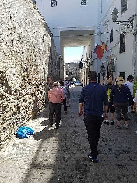
Narrow street in Tangier leading from the Kasbah. In Morocco, the Arabic word "kasbah" refers to multiple buildings in a keep, a citadel, or several structures behind a defensive wall.
Narrow street in Tangier leading from the Kasbah. In Morocco, the Arabic word "kasbah" refers to multiple buildings in a keep, a citadel, or several structures behind a defensive wall. • CIA World Factbook • 2020
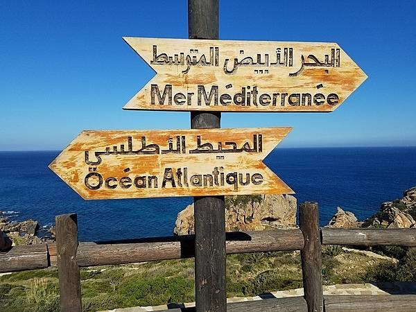
The Atlantic Ocean and the Mediterranean Sea meet at Tangier, Morocco. For the first half of the 20th century Tangier was an international city with its own laws and administration; it was returned to Morocco in 1956.
The Atlantic Ocean and the Mediterranean Sea meet at Tangier, Morocco. For the first half of the 20th century Tangier was an international city with its own laws and administration; it was returned to Morocco in 1956. • CIA World Factbook • 2020
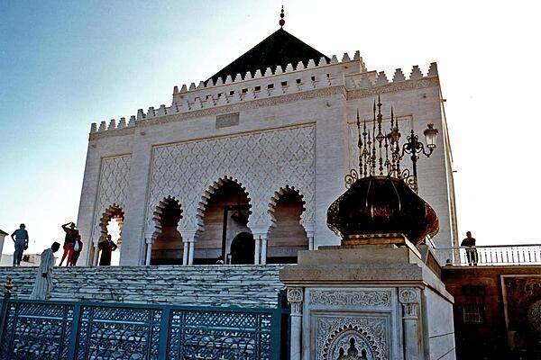
The Mausoleum of Mohammed V in Rabat contains the tombs of the king and his two sons, the late King Hassan II and Prince Abdallah.
The Mausoleum of Mohammed V in Rabat contains the tombs of the king and his two sons, the late King Hassan II and Prince Abdallah. • CIA World Factbook • 2020
A tannery in Fez.
A tannery in Fez. • CIA World Factbook • 2020
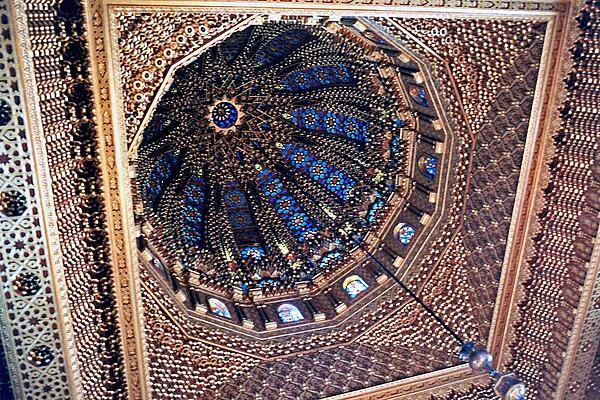
The dome of the Mohammed V Mausoleum in Rabat is breath-taking.
The dome of the Mohammed V Mausoleum in Rabat is breath-taking. • CIA World Factbook • 2020
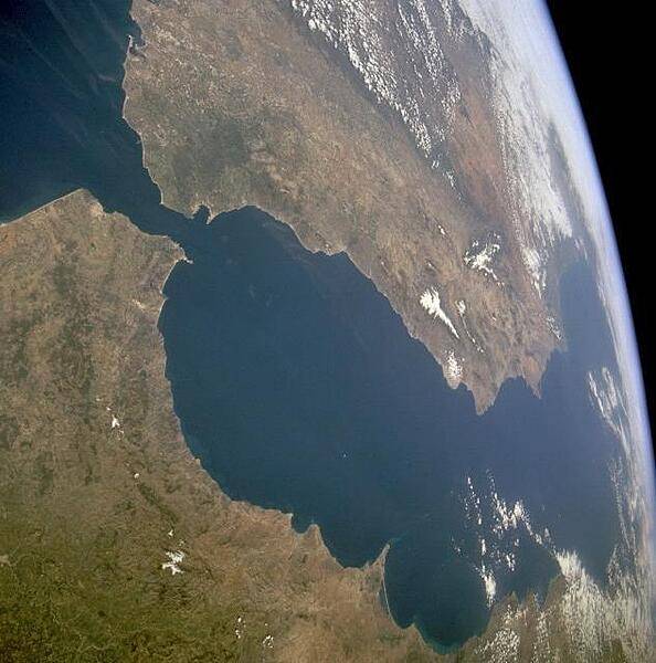
The Strait of Gibraltar provides a natural physical barrier between the countries of Spain (north) and Morocco (south). This photo shows the mountainous northern coast of Morocco and the coastal mountains of southern Spain, including the dagger-shaped, snow-covered Sierra Nevada Mountains of southeastern Spain. The British territory of Gibraltar is located on the thin, wedge-shaped peninsula on the east side of the bay in the southernmost protrusion of Spain. The city of Ceuta is a Spanish enclave on the extreme northeastern coast of Morocco. Image courtesy of NASA.
The Strait of Gibraltar provides a natural physical barrier between the countries of Spain (north) and Morocco (south). This photo shows the mountainous northern coast of Morocco and the coastal mountains of southern Spain, including the dagger-shaped, snow-covered Sierra Nevada Mountains of southeastern Spain. The British territory of Gibraltar is located on the thin, wedge-shaped peninsula on the east side of the bay in the southernmost protrusion of Spain. The city of Ceuta is a Spanish enclave on the extreme northeastern coast of Morocco. Image courtesy of NASA. • CIA World Factbook • 2020
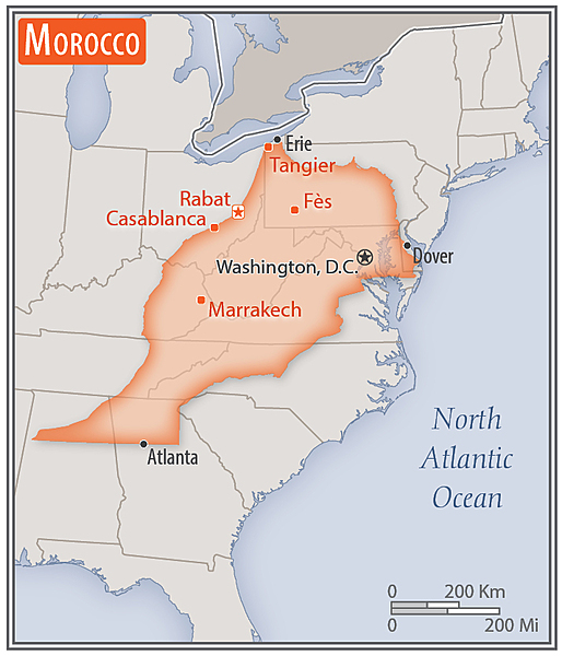
Area comparison map
Area comparison map • CIA World Factbook • 2020
Media source: CIA World Factbook (2020) — Public Domain