›››
Marshall Islands
Marshall Islands
Population
37.5K
Rank #212Source: World Bank
Capital
Majuro
Source: REST Countries
Region
Oceania
East Asia & Pacific
Source: REST Countries
GDP (Nominal)
$290.11M
Rank #191Source: World Bank
Land Area
181 km²
Rank #204Source: REST Countries
Life Expectancy
66.945 yrs
Source: World Bank
Historical Trends
Population Trend (5-Year)
Source: World Bank
GDP Trend (5-Year, Nominal USD)
Source: World Bank
Geography
Area: 181 km²
Landlocked: No
Independent: Yes
Climate: tropical; hot and humid; wet season May to November; islands border typhoon belt
Terrain: low coral limestone and sand islands
Elevation: mean elevation: 2 m lowest point: Pacific Ocean 0 m highest point: East-central Airik Island, Maloelap Atoll 14 m
Natural Hazards: infrequent typhoons
Environmental Issues: inadequate supplies of potable water; pollution of Majuro lagoon from household waste and discharges from fishing vessels; sea level rise
Land Use: agricultural land: 50.7% (2011 est.) forest: 49.3% (2011 est.) other: 0% (2011 est.)
Geography Note: the islands of Bikini and Enewetak are former US nuclear test sites; Kwajalein atoll, famous as a World War II battleground, surrounds the world's largest lagoon and is used as a US missile test...
Natural Resources
coconut productsmarine productsdeep seabed minerals
People & Society
Fertility Rate
2.92
Population
37.5K
Ethnic Groups
Marshallese (92.1%)mixed Marshallese (5.9%)other (2%)
Religions
Protestant 80.5% (United Church of Christ (47%)Assembly of God (16.2%)Bukot Nan Jesus (5.4%)Full Gospel (3.3%)Reformed Congressional Church (3%)Salvation Army (1.9%)Seventh Day Adventist (1.4%)Meram in Jesus (1.2%)other Protestant (1.1%)Roman Catholic (8.5%)Mormon (7%)Jehovah's Witness (1.7%)other (1.2%)none (1.1%)
Economy
GDP per Capita
$7,726.337
GDP per Capita PPP
8,194.639
(2024)
(2024)
GNI per Capita
8,500
(2024)
(2024)
Gini Index
35.5
(2019)
(2019)
Unemployment
Not Available
Inflation
Not Available
Public Debt
41.564%
(2019)
(2019)
Energy
Electricity Access
100%
(2023)
(2023)
Renewable Energy
12.2%
(2022)
(2022)
CO₂ Emissions
Not Available
Energy Intensity
10.96 MJ/$
(2022)
(2022)
Renewable Electricity
2.426%
(2021)
(2021)
Environment
Forest Coverage
52.222% of land
(2023)
(2023)
Protected Areas
0.62% of land
(2009)
(2009)
Communications
Internet Users
65.718%
(2023)
(2023)
Mobile Penetration
39.706%
(2022)
(2022)
Broadband Subscribers
2.35%
(2022)
(2022)
Transportation
Air Transport Freight
0.407 M ton-km
(2023)
(2023)
Container Port Traffic
30,711.22 TEU
(2019)
(2019)
Airports
1,693
Rail Lines
N/A
Roads Total
N/A
Military
Military Forces
no regular military forces; Marshall Islands Police Department
Education
Pre-Primary Enrollment
67.765%
(2021)
(2021)
Primary Enrollment
101.801%
(2024)
(2024)
Secondary Enrollment
85.756%
(2024)
(2024)
Tertiary Enrollment
37.685%
(2024)
(2024)
Education Spending
7.701% of GDP
(2022)
(2022)
Adult Literacy Rate
95.834%
(2021)
(2021)
Pupil-Teacher Ratio
Not Available
Health
Physicians per 1,000
0.467
(2012)
(2012)
Safe Water Access
87.445%
(2024)
(2024)
Safe Drinking Water
Not Available
Under-5 Mortality
28.2 per 1,000
(2023)
(2023)
Maternal Mortality (World Bank)
155 per 100,000
(2023)
(2023)
UHC Coverage Index
66
(2023)
(2023)
Measles Immunization
85%
(2024)
(2024)
Social Indicators
Extreme Poverty Rate
2.1%
(2019)
(2019)
Food Insecurity
Not Available
Youth NEET Rate
24.913%
(2021)
(2021)
Governance
Women in Government
12.121%
(2024)
(2024)
Voice & Accountability
1.13
(Strong)
(2023)
(Strong)
(2023)
Political Stability
1.19
(Strong)
(2023)
(Strong)
(2023)
Government Effectiveness
0.07
(Above Average)
(2023)
(Above Average)
(2023)
Regulatory Quality
-0.42
(Below Average)
(2023)
(Below Average)
(2023)
Rule of Law
0.68
(Above Average)
(2023)
(Above Average)
(2023)
Control of Corruption
0.41
(Above Average)
(2023)
(Above Average)
(2023)
Government
Government Type
mixed presidential-parliamentary system in free association with the US
Legal System
mixed legal system of US and English common law, customary law, and local statutes
Executive Branch
chief of state: President David KABUA (since 13 January 2020); note - the president is both chief of state and head of government head of government: President David KABUA (since 13 January...
Legislative Branch
description: bicameral National Parliament consists of:Council of Iroij, a 12-member group of tribal leaders advises the Presidential Cabinet and reviews legislation affecting customary law or any...
Judicial Branch
highest courts: Supreme Court (consists of the chief justice and 2 associate justices) judge selection and term of office: judges appointed by the Cabinet upon the recommendation of the Judicial...
National Symbols
Flag Description
blue with two stripes radiating from the lower hoist-side corner - orange (top) and white; a white star with four large rays and 20 small rays appears on the hoist side above the two stripes; blue...
National Symbols
a 24-rayed star; national colors: blue, white, orange
National Anthem
name: Forever Marshall Islands lyrics/music: Amata KABUA note: adopted 1981
Travel Information
Language(s): English, Marshallese
Currency: USD ($)
Timezone(s): UTC+12:00
Landlocked: No
Independent: Yes
Driving Side: Right
Calling Code: +692
Car Sign: MH
Week Starts: Monday
Photos
The Soufriere Hills Volcano on the island of Montserrat produced a plume of volcanic ash and/or steam on 1 October 2006, part of a continuing pattern of intermittent eruptions. In this image, the island of Montserrat shows an area outlined in red - the thermal hotspot. The plume of volcanic ash blows westward over the Caribbean Sea, gradually dissipating as it moves away. No recorded eruptions of the volcano occurred before 1995, but since then, volcanic ash emissions have posed recurring health hazards for Montserrat's residents. Photo courtesy of NASA.
The Soufriere Hills Volcano on the island of Montserrat produced a plume of volcanic ash and/or steam on 1 October 2006, part of a continuing pattern of intermittent eruptions. In this image, the island of Montserrat shows an area outlined in red - the thermal hotspot. The plume of volcanic ash blows westward over the Caribbean Sea, gradually dissipating as it moves away. No recorded eruptions of the volcano occurred before 1995, but since then, volcanic ash emissions have posed recurring health hazards for Montserrat's residents. Photo courtesy of NASA. • CIA World Factbook • 2020
A view of Puerto Rico (upper left) and the isles of the Lesser Antilles. The Soufriere Hills Volcano on the island of Montserrat began emitting steam and ash on 9 February 2006. Low-level activity continued for several days. The volcano produced another plume on 20 March 2006, which is captured on this image. The volcano's pale beige ash plume blows westward over the Caribbean Sea. The red outline shows where the satellite detected a thermal anomaly, an area where the ground surface was significantly hotter than its surroundings. Image courtesy of NASA.
A view of Puerto Rico (upper left) and the isles of the Lesser Antilles. The Soufriere Hills Volcano on the island of Montserrat began emitting steam and ash on 9 February 2006. Low-level activity continued for several days. The volcano produced another plume on 20 March 2006, which is captured on this image. The volcano's pale beige ash plume blows westward over the Caribbean Sea. The red outline shows where the satellite detected a thermal anomaly, an area where the ground surface was significantly hotter than its surroundings. Image courtesy of NASA. • CIA World Factbook • 2020
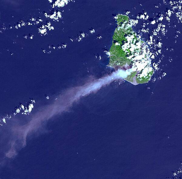
Eruptive activity of the Soufriere Hills Volcano on Montserrat is evidenced by an extensive smoke and ash plume streaming towards the west-southwest (image taken 29 October 2002). Significant eruptive activity began in 1995, forcing the authorities to evacuate about two-thirds of the island's original population of 12,000, and to close off the southern portion of the island. Image courtesy of NASA.
Eruptive activity of the Soufriere Hills Volcano on Montserrat is evidenced by an extensive smoke and ash plume streaming towards the west-southwest (image taken 29 October 2002). Significant eruptive activity began in 1995, forcing the authorities to evacuate about two-thirds of the island's original population of 12,000, and to close off the southern portion of the island. Image courtesy of NASA. • CIA World Factbook • 2020

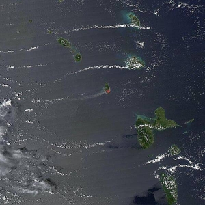
Majuro and Arno Atolls appear as meandering lines of delicate white against a darker ocean background in this satellite image. Areas of shallow water near the shore appear iridescent blue, especially in the southwest portion of each atoll and off the northwest tip of Arno Atoll. Overhead, tiny white clouds dot the sky. Majuro Atoll is 40 km (25 mi) in circumference, and it partially encloses a lagoon of nearly 300 sq km (115 sq mi). The lagoon is far bigger than the atoll itself, whose land area is less than 10 sq km (4 sq mi); walking from the lagoon side to the ocean side of the atoll takes only minutes. Neighboring Arno Atoll encloses three lagoons: two "pinched lagoons" in the northeast and northwest, and a main lagoon of nearly 340 sq km (130 sq mi). Arno's total land area is just 13 sq km (5 sq mi). Scientists have long understood that coral atolls develop around volcanic islands and remain there after those islands have eroded away. To what extent the final shape of an atoll is influenced by wind and ocean wave activity, however, remains a topic of debate. Image courtesy of NASA.
Majuro and Arno Atolls appear as meandering lines of delicate white against a darker ocean background in this satellite image. Areas of shallow water near the shore appear iridescent blue, especially in the southwest portion of each atoll and off the northwest tip of Arno Atoll. Overhead, tiny white clouds dot the sky. Majuro Atoll is 40 km (25 mi) in circumference, and it partially encloses a lagoon of nearly 300 sq km (115 sq mi). The lagoon is far bigger than the atoll itself, whose land area is less than 10 sq km (4 sq mi); walking from the lagoon side to the ocean side of the atoll takes only minutes. Neighboring Arno Atoll encloses three lagoons: two "pinched lagoons" in the northeast and northwest, and a main lagoon of nearly 340 sq km (130 sq mi). Arno's total land area is just 13 sq km (5 sq mi). Scientists have long understood that coral atolls develop around volcanic islands and remain there after those islands have eroded away. To what extent the final shape of an atoll is influenced by wind and ocean wave activity, however, remains a topic of debate. Image courtesy of NASA. • CIA World Factbook • 2020
4 photos available
Data sources: World Bank, UN Data • Updated daily •Learn about our data