›››
Mali
Mali
Population
24.5M
Rank #58Source: World Bank
Capital
Bamako
Source: REST Countries
Region
Africa
Sub-Saharan Africa
Source: REST Countries
GDP (Nominal)
$26.79B
Rank #113Source: World Bank
Land Area
1.2M km²
Rank #24Source: REST Countries
Life Expectancy
60.439 yrs
Source: World Bank
Historical Trends
Population Trend (5-Year)
Source: World Bank
GDP Trend (5-Year, Nominal USD)
Source: World Bank
Geography
Area: 1,240,192 km²
Landlocked: Yes
Independent: Yes
Climate: subtropical to arid; hot and dry (February to June); rainy, humid, and mild (June to November); cool and dry (November to February)
Terrain: mostly flat to rolling northern plains covered by sand; savanna in south, rugged hills in northeast
Elevation: mean elevation: 343 m lowest point: Senegal River 23 m highest point: Hombori Tondo 1,155 m
Natural Hazards: hot, dust-laden harmattan haze common during dry seasons; recurring droughts; occasional Niger River flooding
Environmental Issues: deforestation; soil erosion; desertification; loss of pasture land; inadequate supplies of potable water
Land Use: agricultural land: 34.1% (2011 est.) forest: 10.2% (2011 est.) other: 55.7% (2011 est.)
Geography Note: landlocked; divided into three natural zones: the southern, cultivated Sudanese; the central, semiarid Sahelian; and the northern, arid Saharan
Natural Resources
goldphosphateskaolinsaltlimestoneuraniumgypsumgranitehydropowernote
People & Society
Fertility Rate
5.61
Population
24.5M
Ethnic Groups
Bambara (33.3%)Fulani (Peuhl) (13.3%)Sarakole/Soninke/Marka (9.8%)Senufo/Manianka (9.6%)Malinke (8.8%)Dogon (8.7%)Sonrai (5.9%)Bobo (2.1%)Tuareg/Bella (1.7%)other Malian (6%)from members of Economic Community of West Africa (0.4%)other (0.3%)
Religions
Muslim (93.9%)Christian (2.8%)animist (0.7%)none (2.5%)
Economy
GDP per Capita
$1,094.619
GDP per Capita PPP
3,314.773
(2024)
(2024)
GNI per Capita
1,030
(2024)
(2024)
Gini Index
35.7
(2021)
(2021)
Unemployment
2.924%
(2024)
(2024)
Inflation
3.206%
(2024)
(2024)
Public Debt
Not Available
Energy
Electricity Access
54.5%
(2023)
(2023)
Renewable Energy
71.1%
(2022)
(2022)
CO₂ Emissions
7.412 Mt
(2024)
(2024)
Energy Intensity
6.26 MJ/$
(2022)
(2022)
Renewable Electricity
62.293%
(2021)
(2021)
Environment
Forest Coverage
10.897% of land
(2023)
(2023)
Communications
Internet Users
35.092%
(2023)
(2023)
Mobile Penetration
112.12%
(2022)
(2022)
Broadband Subscribers
0.774%
(2022)
(2022)
Transportation
Air Transport Freight
Not Available
Container Port Traffic
Not Available
Airports
0
Rail Lines
N/A
Roads Total
89,024 km(©IRF)
Military
Military Forces
Malian Armed Forces (FAMa): Army (Armee de Terre), Republic of Mali Air Force (Force Aerienne de la Republique du Mali, FARM); National Gendarmerie; National Guard (Garde National du Mali) note(s):...
Personnel Strength
estimates for the size of the Malian Armed Forces (FAMa) vary; approximately 19,000 total troops (13,000 Army; 800 Air Force; 3,000 Gendarmerie; 2,000 National Guard)
Military Expenditure (USD)
$0.93B
Military Expenditure (% of GDP)
4.20%
Military Expenditure History
2.7% of GDP (2019) 2.9% of GDP (2018) 3% of GDP (2017) 2.6% of GDP (2016) 2.4% of GDP (2015)
Equipment & Inventories
the FAMa's inventory consists primarily of Soviet-era equipment, although in recent years it has received limited quantities of mostly second-hand armaments from a variety of countries; since 2010,...
Service Age & Obligation
18 years of age for selective compulsory and voluntary military service (men and women); 2-year conscript service obligation
Education
Pre-Primary Enrollment
7.596%
(2020)
(2020)
Primary Enrollment
72.797%
(2023)
(2023)
Secondary Enrollment
38.939%
(2023)
(2023)
Tertiary Enrollment
5.128%
(2015)
(2015)
Education Spending
4.185% of GDP
(2023)
(2023)
Adult Literacy Rate
35.47%
(2018)
(2018)
Pupil-Teacher Ratio
37.827:1
(2018)
(2018)
Health
Physicians per 1,000
0.188
(2023)
(2023)
Safe Water Access
86.363%
(2024)
(2024)
Safe Drinking Water
Not Available
Under-5 Mortality
91.3 per 1,000
(2023)
(2023)
Maternal Mortality (World Bank)
16.572 per 100,000
(2021)
(2021)
Hospital Beds per 1,000
62.29
(2021)
(2021)
UHC Coverage Index
41
(2023)
(2023)
Measles Immunization
82%
(2024)
(2024)
Social Indicators
Extreme Poverty Rate
36.1%
(2021)
(2021)
Food Insecurity
12.3%
(2023)
(2023)
Youth NEET Rate
14.463%
(2023)
(2023)
Governance
Women in Government
30.657%
(2024)
(2024)
Voice & Accountability
-1.01
(Weak)
(2023)
(Weak)
(2023)
Political Stability
-2.73
(Weak)
(2023)
(Weak)
(2023)
Government Effectiveness
-1.14
(Weak)
(2023)
(Weak)
(2023)
Regulatory Quality
-0.68
(Below Average)
(2023)
(Below Average)
(2023)
Rule of Law
-0.98
(Below Average)
(2023)
(Below Average)
(2023)
Control of Corruption
-0.86
(Below Average)
(2023)
(Below Average)
(2023)
Government
Government Type
semi-presidential republic
Legal System
civil law system based on the French civil law model and influenced by customary law; judicial review of legislative acts in the Constitutional Court
Executive Branch
chief of state: President of transitional government, Bah NDAW (since 25 September 2020); vice president of the transitional government, Assimi GOITA (since 25 September 2020); former president...
Legislative Branch
description: unicameral National Assembly or Assemblee Nationale (147 seats; members directly elected in single and multi-seat constituencies by absolute majority vote in 2 rounds if needed; 13 seats...
Judicial Branch
highest courts: Supreme Court or Cour Supreme (consists of 19 judges organized into judicial, administrative, and accounting sectons); Constitutional Court (consists of 9 judges) judge selection and...
National Symbols
Flag Description
three equal vertical bands of green (hoist side), yellow, and rednote: uses the popular Pan-African colors of Ethiopia; the colors from left to right are the same as those of neighboring Senegal...
National Symbols
Great Mosque of Djenne; national colors: green, yellow, red
National Anthem
name: "Le Mali" (Mali) lyrics/music: Seydou Badian KOUYATE/Banzoumana SISSOKO note: adopted 1962; also known as "Pour L'Afrique et pour toi, Mali" (For Africa and for You, Mali) and "A ton appel...
Travel Information
Language(s): French
Currency: XOF (Fr)
Timezone(s): UTC
Landlocked: Yes
Independent: Yes
Driving Side: Right
Calling Code: +223
Car Sign: RMM
Week Starts: Monday
Photos
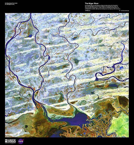
Coursing through parched, landlocked Mali, the Niger River flows north through an ancient sand sea before turning sharply east to skirt the edge of the dune-striped Sahara; it then heads south, through Niger, Benin, and Nigeria, to the Gulf of Guinea. At the confluence of the Bani and Niger Rivers in Mali lies a vast Inner Niger Delta the size of Belgium and composed of narrows, twisting waterways, lagoons, and tiny islands (some of which are shown here). Due to evaporation and seepage in this area, the river loses two thirds of its potential flow. The Niger River's strange crescent-shaped route is believed to have been formed when two ancient rivers merged as the region dried. From the Niger's source near the coast to the bend, the Upper Niger once emptied into a now gone lake. In the hills near the ancient lake, the Lower Niger began and flowed south to the Gulf of Guinea. False-color image courtesy of USGS.
Coursing through parched, landlocked Mali, the Niger River flows north through an ancient sand sea before turning sharply east to skirt the edge of the dune-striped Sahara; it then heads south, through Niger, Benin, and Nigeria, to the Gulf of Guinea. At the confluence of the Bani and Niger Rivers in Mali lies a vast Inner Niger Delta the size of Belgium and composed of narrows, twisting waterways, lagoons, and tiny islands (some of which are shown here). Due to evaporation and seepage in this area, the river loses two thirds of its potential flow. The Niger River's strange crescent-shaped route is believed to have been formed when two ancient rivers merged as the region dried. From the Niger's source near the coast to the bend, the Upper Niger once emptied into a now gone lake. In the hills near the ancient lake, the Lower Niger began and flowed south to the Gulf of Guinea. False-color image courtesy of USGS. • CIA World Factbook • 2020
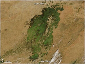
In the middle of Mali, part of the landscape gleams like a giant emerald in the otherwise arid brown African Sahel. The gleaming jewel is the Inland Niger Delta. Fed by floodwaters from the Niger River, the Bani River, and a network of smaller streams, this inland delta grows to some 20,000 sq km (7,700 sq mi) during the four-month rainy season that begins each July. During the dry season, the inland delta can shrink to roughly 3,900 sq km (1,500 sq mi). This satellite picture of the Inland Niger Delta was taken shortly after the end of the rainy season when the landscape remained lush and green. This inland delta is a complex combination of river channels, lakes, swamps, and occasional areas of higher elevation. One such elevated area is obvious in this image, and it forms a branching shape, like a tan tree pushing up toward the north. This wet oasis in the African Sahel provides habitat both for migrating birds and West African manatees. The fertile floodplains also provide much needed resources for the local people, who use the area for fishing, grazing livestock, and cultivating rice. Image courtesy of NASA.
In the middle of Mali, part of the landscape gleams like a giant emerald in the otherwise arid brown African Sahel. The gleaming jewel is the Inland Niger Delta. Fed by floodwaters from the Niger River, the Bani River, and a network of smaller streams, this inland delta grows to some 20,000 sq km (7,700 sq mi) during the four-month rainy season that begins each July. During the dry season, the inland delta can shrink to roughly 3,900 sq km (1,500 sq mi).
This satellite picture of the Inland Niger Delta was taken shortly after the end of the rainy season when the landscape remained lush and green. This inland delta is a complex combination of river channels, lakes, swamps, and occasional areas of higher elevation. One such elevated area is obvious in this image, and it forms a branching shape, like a tan tree pushing up toward the north. This wet oasis in the African Sahel provides habitat both for migrating birds and West African manatees. The fertile floodplains also provide much needed resources for the local people, who use the area for fishing, grazing livestock, and cultivating rice. Image courtesy of NASA. • CIA World Factbook • 2020
2 photos available
Data sources: World Bank, UN Data • Updated daily •Learn about our data