›››
Myanmar
Myanmar
Population
54.5M
Rank #27Source: World Bank
Capital
Naypyidaw
Source: REST Countries
Region
Asia
East Asia & Pacific
Source: REST Countries
GDP (Nominal)
$74.07B
Rank #85Source: World Bank
Land Area
676.6K km²
Rank #40Source: REST Countries
Life Expectancy
66.889 yrs
Source: World Bank
Historical Trends
Population Trend (5-Year)
Source: World Bank
GDP Trend (5-Year, Nominal USD)
Source: World Bank
Geography
Area: 676,578 km²
Landlocked: No
Independent: Yes
Climate: tropical monsoon; cloudy, rainy, hot, humid summers (southwest monsoon, June to September); less cloudy, scant rainfall, mild temperatures, lower humidity during winter (northeast monsoon, December...
Terrain: central lowlands ringed by steep, rugged highlands
Elevation: mean elevation: 702 m lowest point: Andaman Sea/Bay of Bengal 0 m highest point: Gamlang Razi 5,870 m
Natural Hazards: destructive earthquakes and cyclones; flooding and landslides common during rainy season (June to September); periodic droughts
Environmental Issues: deforestation; industrial pollution of air, soil, and water; inadequate sanitation and water treatment contribute to disease; rapid depletion of the country's natural resources
Land Use: agricultural land: 19.2% (2011 est.) forest: 48.2% (2011 est.) other: 32.6% (2011 est.)
Geography Note: strategic location near major Indian Ocean shipping lanes; the north-south flowing Irrawaddy River is the country's largest and most important commercial waterway
Natural Resources
petroleumtimbertinantimonyzinccoppertungstenleadcoalmarble
People & Society
Fertility Rate
2.12
Population
54.5M
Ethnic Groups
Burman (Bamar) (68%)Shan (9%)Karen (7%)Rakhine (4%)Chinese (3%)Indian (2%)Mon (2%)other (5%)
Religions
Buddhist (87.9%)Christian (6.2%)Muslim (4.3%)Animist (0.8%)Hindu (0.5%)other (0.2%)none (0.1%)Muslims probably make up less than (3%)
Economy
GDP per Capita
$1,359.05
GDP per Capita PPP
5,997.465
(2024)
(2024)
GNI per Capita
1,210
(2024)
(2024)
Gini Index
30.7
(2017)
(2017)
Unemployment
2.887%
(2024)
(2024)
Inflation
8.825%
(2019)
(2019)
Public Debt
Not Available
Energy
Electricity Access
76.8%
(2023)
(2023)
Renewable Energy
62.9%
(2021)
(2021)
CO₂ Emissions
31.363 Mt
(2024)
(2024)
Energy Intensity
4.17 MJ/$
(2021)
(2021)
Renewable Electricity
62.074%
(2021)
(2021)
Environment
Forest Coverage
42.402% of land
(2023)
(2023)
Communications
Internet Users
58.536%
(2023)
(2023)
Mobile Penetration
121.028%
(2023)
(2023)
Broadband Subscribers
2.798%
(2023)
(2023)
Transportation
Air Transport Freight
9.931 M ton-km
(2023)
(2023)
Container Port Traffic
846,426 TEU
(2022)
(2022)
Airports
43,257
Rail Lines
N/A
Roads Total
N/A
Military
Military Forces
Burmese Defense Service (Tatmadaw): Army (Tatmadaw Kyi), Navy (Tatmadaw Yay), Air Force (Tatmadaw Lay), Directorate of People’s Militia and Border Guard Forces
Personnel Strength
estimates of the Burmese Defense Service (Tatmadaw) vary widely; approximately 380,000 total active troops (est. 340,000 Army; 20,000 Navy; 20,000 Air Force); est. 35,000 People’s Militia
Military Expenditure (USD)
$5.01B
Military Expenditure (% of GDP)
6.79%
Military Expenditure History
2.9% of GDP (2018) 3.2% of GDP (2017) 3.7% of GDP (2016) 4.1% of GDP (2015) 3.6% of GDP (2014)
Equipment & Inventories
the Burmese Defense Service's inventory is comprised mostly of older Chinese and Russian/Soviet-era equipment with a smaller mix of more modern acquisitions; since 2010, China and Russia are the...
Service Age & Obligation
18-35 years of age (men) and 18-27 years of age (women) for voluntary military service; no conscription (a 2010 law reintroducing conscription has not yet entered into force); 2-year service...
Education
Pre-Primary Enrollment
8.531%
(2018)
(2018)
Primary Enrollment
120.215%
(2018)
(2018)
Secondary Enrollment
77.019%
(2018)
(2018)
Tertiary Enrollment
20.372%
(2018)
(2018)
Education Spending
2% of GDP
(2019)
(2019)
Adult Literacy Rate
93.547%
(2020)
(2020)
Pupil-Teacher Ratio
24.36:1
(2018)
(2018)
Health
Physicians per 1,000
0.757
(2019)
(2019)
Safe Water Access
85.687%
(2024)
(2024)
Safe Drinking Water
59.724%
(2024)
(2024)
Under-5 Mortality
38.7 per 1,000
(2023)
(2023)
Maternal Mortality (World Bank)
18.718 per 100,000
(2021)
(2021)
Hospital Beds per 1,000
64.71
(2021)
(2021)
UHC Coverage Index
52
(2023)
(2023)
Measles Immunization
71%
(2024)
(2024)
Social Indicators
Extreme Poverty Rate
10.3%
(2017)
(2017)
Food Insecurity
5.4%
(2023)
(2023)
Youth NEET Rate
4.876%
(2020)
(2020)
Governance
Women in Government
Not Available
Voice & Accountability
-1.84
(Weak)
(2023)
(Weak)
(2023)
Political Stability
-2.13
(Weak)
(2023)
(Weak)
(2023)
Government Effectiveness
-1.75
(Weak)
(2023)
(Weak)
(2023)
Regulatory Quality
-1.44
(Weak)
(2023)
(Weak)
(2023)
Rule of Law
-1.62
(Weak)
(2023)
(Weak)
(2023)
Control of Corruption
-1.22
(Weak)
(2023)
(Weak)
(2023)
Government
Government Type
parliamentary republic
Legal System
mixed legal system of English common law (as introduced in codifications designed for colonial India) and customary law
Executive Branch
chief of state: President WIN MYINT (since 30 March 2018); Vice Presidents MYINT SWE (since 16 March 2016) and HENRY VAN THIO (since 30 March 2016); note - President HTIN KYAW (since 30 March 2016)...
Legislative Branch
description: bicameral Assembly of the Union or Pyidaungsu consists of:House of Nationalities or Amyotha Hluttaw, (224 seats; 168 members directly elected in single-seat constituencies by absolute...
Judicial Branch
highest courts: Supreme Court of the Union (consists of the chief justice and 7-11 judges) judge selection and term of office: chief justice and judges nominated by the president, with approval of...
National Symbols
Flag Description
design consists of three equal horizontal stripes of yellow (top), green, and red; centered on the green band is a large white five-pointed star that partially overlaps onto the adjacent colored...
National Symbols
chinthe (mythical lion); national colors: yellow, green, red, white
National Anthem
name: "Kaba Ma Kyei" (Till the End of the World, Myanmar) lyrics/music: SAYA TIN note: adopted 1948; Burma is among a handful of non-European nations that have anthems rooted in indigenous...
Safety
Homicide Rate
2.575 per 100,000
(2023)
(2023)
Travel Information
Language(s): Burmese
Currency: MMK (Ks)
Timezone(s): UTC+06:30
Landlocked: No
Independent: Yes
Driving Side: Right
Calling Code: +95
Car Sign: BUR
Week Starts: Monday
Photos
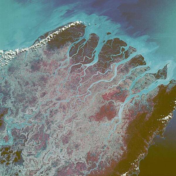
Infrared film helps accentuate plant growth and sediment accumulations in this near-vertical photograph of the numerous mouths of the Irrawaddy River in western Burma. The Irrawaddy Delta, one of the world's great rice-producing regions, consists of fertile river mud and sand deposited during the last 2 million years. The deep reds and violets at the southern end of the multichanneled delta (top of photo) reflect large mangrove forests. The light blues show the sediment plumes within the stream channels extending southward into the Andaman Sea. Image courtesy of NASA.
Infrared film helps accentuate plant growth and sediment accumulations in this near-vertical photograph of the numerous mouths of the Irrawaddy River in western Burma. The Irrawaddy Delta, one of the world's great rice-producing regions, consists of fertile river mud and sand deposited during the last 2 million years. The deep reds and violets at the southern end of the multichanneled delta (top of photo) reflect large mangrove forests. The light blues show the sediment plumes within the stream channels extending southward into the Andaman Sea. Image courtesy of NASA. • CIA World Factbook • 2020
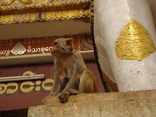
Mount Popa, an extinct volcano, is located southeast of Bagan. It has become the site of religious and mystical interests, notably "nats" or the spirits of ancient ancestors. A monastery sits atop the volcano and houses several monkeys.
Mount Popa, an extinct volcano, is located southeast of Bagan. It has become the site of religious and mystical interests, notably "nats" or the spirits of ancient ancestors. A monastery sits atop the volcano and houses several monkeys. • CIA World Factbook • 2020
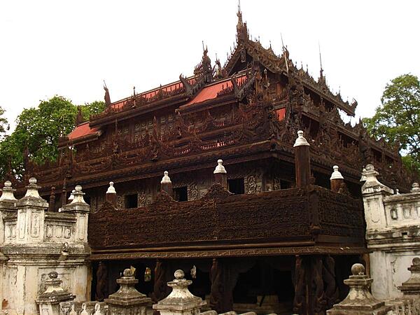
The Shwenandaw Kyaung Temple was originally part of the royal palace in Amarapura but was moved to nearby Mandalay where is remains today. King Mindo died in the building in 1878 and it was later converted into a monastery dedicated to his memory. The building is made of teak and has intricate wood carvings located throughout the structure.
The Shwenandaw Kyaung Temple was originally part of the royal palace in Amarapura but was moved to nearby Mandalay where is remains today. King Mindo died in the building in 1878 and it was later converted into a monastery dedicated to his memory. The building is made of teak and has intricate wood carvings located throughout the structure. • CIA World Factbook • 2020
Ananda Temple is one of the four main temples remaining in Bagan. It is said to have been built around A.D. 1105 by King Kyanzittha and showcases traditional Mon architecture.
Ananda Temple is one of the four main temples remaining in Bagan. It is said to have been built around A.D. 1105 by King Kyanzittha and showcases traditional Mon architecture. • CIA World Factbook • 2020
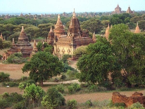
The ancient city of Bagan is located in Mandalay Division and is home to over 2,000 pagodas and temples. The majority of the buildings were built during the 11th to 13th centuries when Bagan was the capital of the Burmese Empire.
The ancient city of Bagan is located in Mandalay Division and is home to over 2,000 pagodas and temples. The majority of the buildings were built during the 11th to 13th centuries when Bagan was the capital of the Burmese Empire. • CIA World Factbook • 2020
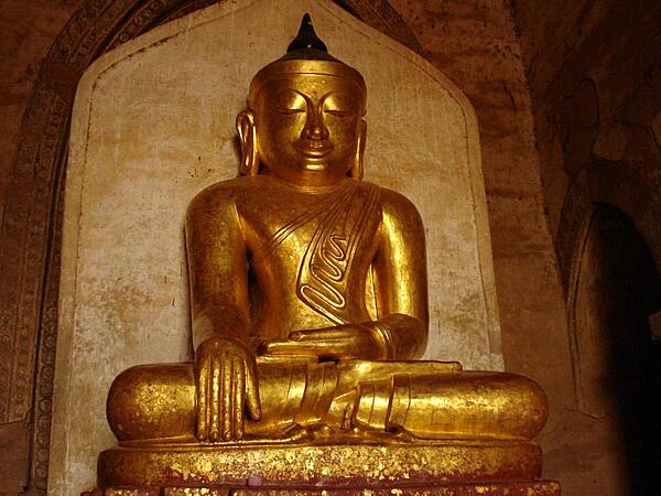
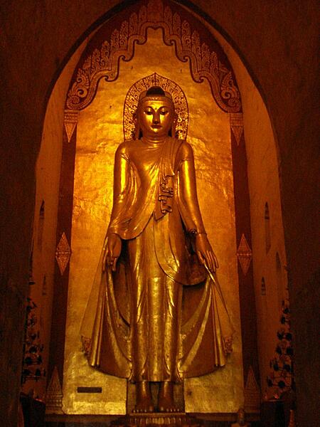
A golden Buddha statue sits in one of Bagan's many pagodas.
A golden Buddha statue sits in one of Bagan's many pagodas. • CIA World Factbook • 2020
14 photos available
View All Photos→Data sources: World Bank, UN Data • Updated daily •Learn about our data