›››
Mauritania
Mauritania
Population
5.2M
Rank #125Source: World Bank
Capital
Nouakchott
Source: REST Countries
Region
Africa
Sub-Saharan Africa
Source: REST Countries
GDP (Nominal)
$10.91B
Rank #149Source: World Bank
Land Area
1.0M km²
Rank #29Source: REST Countries
Life Expectancy
68.484 yrs
Source: World Bank
Historical Trends
Population Trend (5-Year)
Source: World Bank
GDP Trend (5-Year, Nominal USD)
Source: World Bank
Geography
Area: 1,030,700 km²
Landlocked: No
Independent: Yes
Climate: desert; constantly hot, dry, dusty
Terrain: mostly barren, flat plains of the Sahara; some central hills
Elevation: mean elevation: 276 m lowest point: Sebkhet Te-n-Dghamcha -5 m highest point: Kediet Ijill 915 m
Natural Hazards: hot, dry, dust/sand-laden sirocco wind primarily in March and April; periodic droughts
Environmental Issues: overgrazing, deforestation, and soil erosion aggravated by drought are contributing to desertification; limited natural freshwater resources away from the Senegal, which is the only perennial river;...
Land Use: agricultural land: 38.5% (2011 est.) forest: 0.2% (2011 est.) other: 61.3% (2011 est.)
Geography Note: Mauritania is considered both a part of North Africa's Maghreb region and West Africa's Sahel region; most of the population is concentrated in the cities of Nouakchott and Nouadhibou and along the...
Natural Resources
iron oregypsumcopperphosphatediamondsgoldoilfish
People & Society
Fertility Rate
4.70
Population
5.2M
Ethnic Groups
Black Moors (Haratines - Arab-speaking slaves, former slaves, and their descendants of African origin, enslaved by white Moors) (40%)White Moors (of Arab-Berber descent, known as Beydane) (30%)Sub-Saharan Mauritanians (non-Arabic speaking, largely resident in or originating from the Senegal River Valley, including Halpulaar, Fulani, Soninke, Wolof, and Bambara ethnic groups) (30%)
Religions
Muslim (official) (100%)
Economy
GDP per Capita
$2,110.12
GDP per Capita PPP
7,368.753
(2024)
(2024)
GNI per Capita
2,120
(2024)
(2024)
Gini Index
32
(2019)
(2019)
Unemployment
10.257%
(2024)
(2024)
Inflation
2.492%
(2024)
(2024)
Public Debt
Not Available
Energy
Electricity Access
50.3%
(2023)
(2023)
Renewable Energy
19.6%
(2022)
(2022)
CO₂ Emissions
5.012 Mt
(2024)
(2024)
Energy Intensity
3.74 MJ/$
(2022)
(2022)
Renewable Electricity
19.355%
(2021)
(2021)
Environment
Forest Coverage
0.288% of land
(2023)
(2023)
Communications
Internet Users
37.381%
(2023)
(2023)
Mobile Penetration
90.773%
(2023)
(2023)
Broadband Subscribers
0.59%
(2023)
(2023)
Transportation
Air Transport Freight
Not Available
Container Port Traffic
84,457.99 TEU
(2019)
(2019)
Airports
4,365
Rail Lines
728 km
Roads Total
N/A
Military
Military Forces
Mauritanian Armed Forces: Army, Mauritanian Navy (Marine Mauritanienne), Islamic Republic of Mauritania Air Group (Groupement Aerienne Islamique de Mauritanie, GAIM); Ministry of Interior:...
Personnel Strength
the Mauritanian Armed Forces have approximately 16,000 active personnel (15,000 Army; 700 Navy; 300 Air Force); est. 3,000 Gendarmerie; est. 2,000 National Guard)
Military Expenditure (USD)
$0.26B
Military Expenditure (% of GDP)
2.15%
Military Expenditure History
2.8% of GDP (2019) 3% of GDP (2018) 2.9% of GDP (2017) 2.9% of GDP (2016) 2.8% of GDP (2015)
Deployments
450 Central African Republic (MINUSCA) (2020)
Equipment & Inventories
the Mauritanian Armed Forces' inventory is limited and made up largely of older French and Soviet-era equipment; since 2010, Mauritania has received mostly secondhand military equipment from a...
Service Age & Obligation
18 is the legal minimum age for voluntary military service; no conscription
Education
Pre-Primary Enrollment
10.491%
(2015)
(2015)
Primary Enrollment
105.435%
(2024)
(2024)
Secondary Enrollment
36.028%
(2020)
(2020)
Tertiary Enrollment
5.972%
(2020)
(2020)
Education Spending
4.715% of GDP
(2023)
(2023)
Adult Literacy Rate
59.53%
(2020)
(2020)
Pupil-Teacher Ratio
34.278:1
(2018)
(2018)
Health
Physicians per 1,000
0.261
(2022)
(2022)
Safe Water Access
77.285%
(2024)
(2024)
Safe Drinking Water
Not Available
Under-5 Mortality
37.8 per 1,000
(2023)
(2023)
Maternal Mortality (World Bank)
17.425 per 100,000
(2021)
(2021)
Hospital Beds per 1,000
68.868
(2021)
(2021)
UHC Coverage Index
40
(2023)
(2023)
Measles Immunization
86%
(2024)
(2024)
Social Indicators
Extreme Poverty Rate
10.2%
(2019)
(2019)
Food Insecurity
8.7%
(2023)
(2023)
Youth NEET Rate
22.765%
(2019)
(2019)
Governance
Women in Government
23.295%
(2024)
(2024)
Voice & Accountability
-0.66
(Below Average)
(2023)
(Below Average)
(2023)
Political Stability
-0.50
(Below Average)
(2023)
(Below Average)
(2023)
Government Effectiveness
-0.76
(Below Average)
(2023)
(Below Average)
(2023)
Regulatory Quality
-1.00
(Below Average)
(2023)
(Below Average)
(2023)
Rule of Law
-0.64
(Below Average)
(2023)
(Below Average)
(2023)
Control of Corruption
-0.82
(Below Average)
(2023)
(Below Average)
(2023)
Government
Government Type
presidential republic
Legal System
mixed legal system of Islamic and French civil law
Executive Branch
chief of state: President Mohamed Cheikh El GHAZOUANI (since 1 August 2019) head of government: Prime Minister Mohamed Ould BILAL (since 6 August 2020) cabinet: Council of Ministers - nominees...
Legislative Branch
description: unicameral Parliament or Barlamane consists of the National Assembly or Al Jamiya Al Wataniya (157 seats; 113 members in single- and multi-seat constituencies directly elected by a...
Judicial Branch
highest courts: Supreme Court or Cour Supreme (subdivided into 7 chambers: 2 civil, 2 labor, 1 commercial, 1 administrative, and 1 criminal, each with a chamber president and 2 councilors );...
National Symbols
Flag Description
green with a yellow, five-pointed star between the horns of a yellow, upward-pointing crescent moon; red stripes along the top and bottom edges; the crescent, star, and color green are traditional...
National Symbols
five-pointed star between the horns of a horizontal crescent moon; national colors: green, yellow
National Anthem
name: "Hymne National de la Republique Islamique de Mauritanie" (National Anthem of the Islamic Republic of Mauritania) lyrics/music: Baba Ould CHEIKH/traditional, arranged by Tolia...
Safety
Homicide Rate
1 per 100,000
(2020)
(2020)
Travel Information
Language(s): Arabic
Currency: MRU (UM)
Timezone(s): UTC
Landlocked: No
Independent: Yes
Driving Side: Right
Calling Code: +222
Car Sign: RIM
Week Starts: Monday
Photos
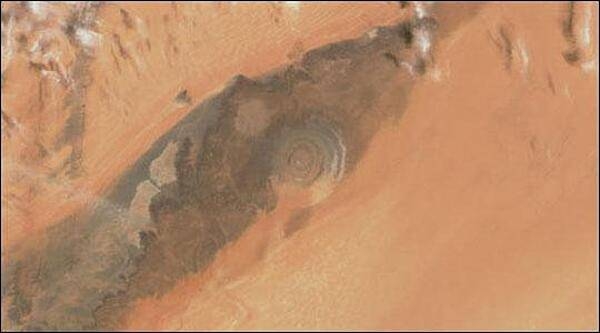
The Richat Structure, a prominent circular feature in the Sahara Desert of Mauritania, has attracted attention since the earliest space missions because it forms a conspicuous bull's-eye in the otherwise rather featureless expanse of the Gres de Chinguetti Plateau in central Mauritania. The Structure, which has a diameter of almost 50 km (30 mi), has become a landmark for space shuttle crews. Initially interpreted as a meteorite impact structure, it is now thought to be merely a symmetrical uplift (circular anticline) laid bare by erosion. Image courtesy of NASA.
The Richat Structure, a prominent circular feature in the Sahara Desert of Mauritania, has attracted attention since the earliest space missions because it forms a conspicuous bull's-eye in the otherwise rather featureless expanse of the Gres de Chinguetti Plateau in central Mauritania. The Structure, which has a diameter of almost 50 km (30 mi), has become a landmark for space shuttle crews. Initially interpreted as a meteorite impact structure, it is now thought to be merely a symmetrical uplift (circular anticline) laid bare by erosion. Image courtesy of NASA. • CIA World Factbook • 2020
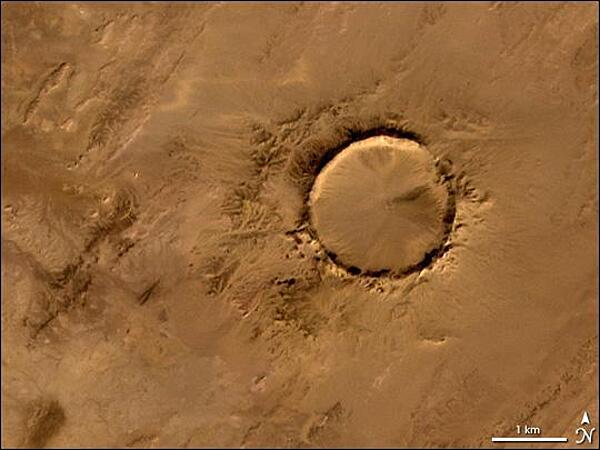
Deep in the Sahara lies a crater, a nearly a perfect circle that is 1.9 km (1.2 mi) wide, and sports a rim 100 m (330 ft) high. The Tenoumer crater sits in a vast plain of rocks so ancient they were deposited hundreds of millions of years before the first dinosaurs walked the Earth. Close examination of the structure has revealed that the crater's hardened "lava" was actually rock that had melted from a meteorite impact. On this satellite image the crater's outline is unmistakable, yet it does not necessarily look like a crater; the light and shadows make it look more as if someone pressed a giant cookie cutter into the rock. In this image, the sunlight shines from the southeast (lower right), and the bright arc along the northwestern part of the crater is where the crater walls slope up to the rim. Around the perimeter, the relatively steep walls cast dark shadows. Although it resides in ancient rock, Tenoumer is geologically young, ranging in age between roughly 10,000 and 30,000 years old. Photo courtesy of NASA.
Deep in the Sahara lies a crater, a nearly a perfect circle that is 1.9 km (1.2 mi) wide, and sports a rim 100 m (330 ft) high. The Tenoumer crater sits in a vast plain of rocks so ancient they were deposited hundreds of millions of years before the first dinosaurs walked the Earth. Close examination of the structure has revealed that the crater's hardened "lava" was actually rock that had melted from a meteorite impact.
On this satellite image the crater's outline is unmistakable, yet it does not necessarily look like a crater; the light and shadows make it look more as if someone pressed a giant cookie cutter into the rock. In this image, the sunlight shines from the southeast (lower right), and the bright arc along the northwestern part of the crater is where the crater walls slope up to the rim. Around the perimeter, the relatively steep walls cast dark shadows. Although it resides in ancient rock, Tenoumer is geologically young, ranging in age between roughly 10,000 and 30,000 years old. Photo courtesy of NASA. • CIA World Factbook • 2020
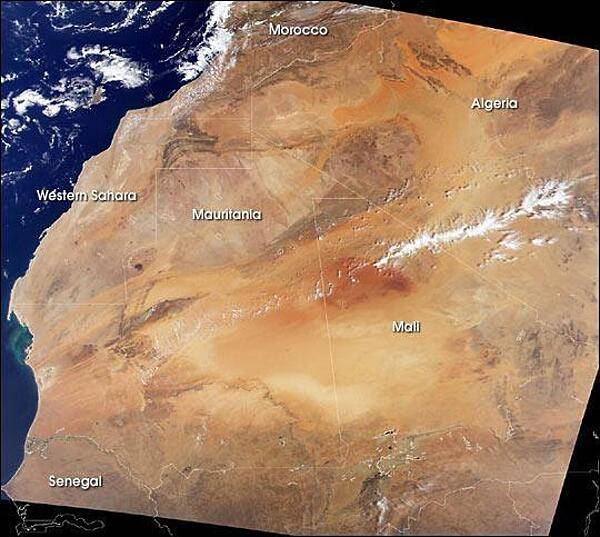
A remarkably clear satellite image of northwestern Africa vividly displays the extent of the Sahara. To the north are the dark brown Atlas Mountains of Morocco, to the west is the Atlantic Ocean, and to the south is the semi-arid (light brown) Sahelian region. The largely desert composition of Mauritania restricts human settlement. Population centers are mostly confined to the Atlantic coast or along the Senegal River in the southwest. Photo courtesy of NASA.
A remarkably clear satellite image of northwestern Africa vividly displays the extent of the Sahara. To the north are the dark brown Atlas Mountains of Morocco, to the west is the Atlantic Ocean, and to the south is the semi-arid (light brown) Sahelian region. The largely desert composition of Mauritania restricts human settlement. Population centers are mostly confined to the Atlantic coast or along the Senegal River in the southwest. Photo courtesy of NASA. • CIA World Factbook • 2020
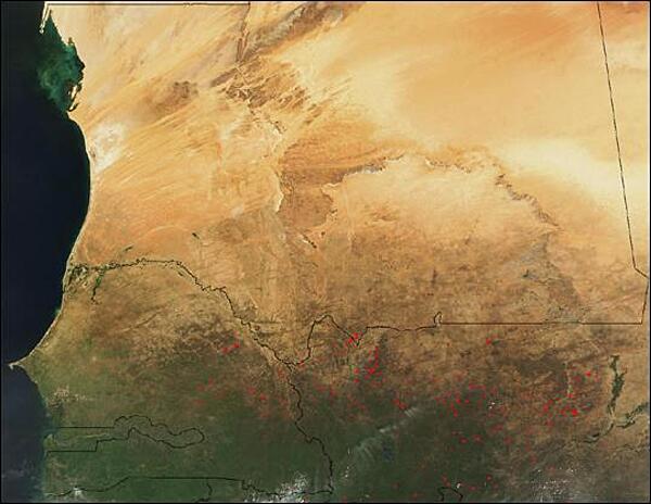
This satellite photo shows dozens of fires burning in the African countries of Senegal (left) and Mali (right). To the north is the largely desert country of Mauritania. In roughly the center of Mauritania, the dark brown area indicates the location of seasonal lakes and rivers - dry when this October image was snapped. Photo courtesy of NASA.
This satellite photo shows dozens of fires burning in the African countries of Senegal (left) and Mali (right). To the north is the largely desert country of Mauritania. In roughly the center of Mauritania, the dark brown area indicates the location of seasonal lakes and rivers - dry when this October image was snapped. Photo courtesy of NASA. • CIA World Factbook • 2020
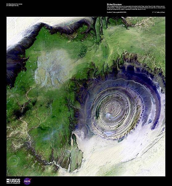
The so-called Richat Structure, center right in this false-color satellite image, is a geological formation in the Maur Adrar Desert. Compare this image to the true-color photo taken from a spacecraft. Although it resembles an impact crater, the Richat Structure formed when a volcanic dome hardened and gradually eroded, exposing the onion-like layers of rock. Image courtesy of USGS.
The so-called Richat Structure, center right in this false-color satellite image, is a geological formation in the Maur Adrar Desert. Compare this image to the true-color photo taken from a spacecraft. Although it resembles an impact crater, the Richat Structure formed when a volcanic dome hardened and gradually eroded, exposing the onion-like layers of rock. Image courtesy of USGS. • CIA World Factbook • 2020
Area comparison map
Area comparison map • CIA World Factbook • 2020
6 photos available
Data sources: World Bank, UN Data • Updated daily •Learn about our data