›››
Mozambique
Mozambique
Population
34.6M
Rank #46Source: World Bank
Capital
Maputo
Source: REST Countries
Region
Africa
Sub-Saharan Africa
Source: REST Countries
GDP (Nominal)
$22.75B
Rank #123Source: World Bank
Land Area
801.6K km²
Rank #35Source: REST Countries
Life Expectancy
63.611 yrs
Source: World Bank
Historical Trends
Population Trend (5-Year)
Source: World Bank
GDP Trend (5-Year, Nominal USD)
Source: World Bank
Geography
Area: 801,590 km²
Landlocked: No
Independent: Yes
Climate: tropical to subtropical
Terrain: mostly coastal lowlands, uplands in center, high plateaus in northwest, mountains in west
Elevation: mean elevation: 345 m lowest point: Indian Ocean 0 m highest point: Monte Binga 2,436 m
Natural Hazards: severe droughts; devastating cyclones and floods in central and southern provinces
Environmental Issues: increased migration of the population to urban and coastal areas with adverse environmental consequences; desertification; soil erosion; deforestation; water pollution caused by artisanal mining;...
Land Use: agricultural land: 56.3% (2011 est.) forest: 43.7% (2011 est.) other: 0% (2011 est.)
Geography Note: the Zambezi River flows through the north-central and most fertile part of the country
Natural Resources
coaltitaniumnatural gashydropowertantalumgraphite
People & Society
Fertility Rate
4.76
Population
34.6M
Ethnic Groups
African (99%)Mestizo (0.8%)other (includes European, Indian, Pakistani, Chinese) (0.2%)
Religions
Roman Catholic (27.2%)Muslim (18.9%)Zionist Christian (15.6%)Evangelical/Pentecostal (15.3%)Anglican (1.7%)other (4.8%)none (13.9%)unspecified (2.5%)
Economy
GDP per Capita
$656.777
GDP per Capita PPP
1,705.379
(2024)
(2024)
GNI per Capita
550
(2024)
(2024)
Gini Index
49.6
(2022)
(2022)
Unemployment
6.668%
(2024)
(2024)
Inflation
4.079%
(2024)
(2024)
Public Debt
71.793%
(2024)
(2024)
Energy
Electricity Access
36%
(2023)
(2023)
Renewable Energy
76.9%
(2021)
(2021)
CO₂ Emissions
10.113 Mt
(2024)
(2024)
Energy Intensity
11.95 MJ/$
(2021)
(2021)
Renewable Electricity
82.718%
(2021)
(2021)
Environment
Forest Coverage
45.813% of land
(2023)
(2023)
Communications
Internet Users
19.843%
(2023)
(2023)
Mobile Penetration
45.818%
(2022)
(2022)
Broadband Subscribers
0.198%
(2022)
(2022)
Transportation
Air Transport Freight
3.016 M ton-km
(2023)
(2023)
Container Port Traffic
420,500 TEU
(2022)
(2022)
Airports
12,839
Rail Lines
3,116 km
Roads Total
30,616 km(©IRF)
Military
Military Forces
Armed Defense Forces of Mozambique (Forcas Armadas de Defesa de Mocambique, FADM): Mozambique Army, Mozambique Navy (Marinha de Guerra de Mocambique, MGM), Mozambique Air Force (Forca Aerea de...
Personnel Strength
the Armed Defense Forces of Mozambique (FADM) are comprised of approximately 11,000 personnel (10,000 Army; 200 Navy; 1,000 Air Force)
Military Expenditure (USD)
$0.45B
Military Expenditure (% of GDP)
1.99%
Military Expenditure History
0.99% of GDP (2018) 1.02% of GDP (2017) 1.03% of GDP (2016) 0.81% of GDP (2015) 1.02% of GDP (2014)
Equipment & Inventories
the FADM's inventory consists primarily of Soviet-era equipment, although in recent years it has received limited quantities of newer equipment, particularly aircraft and maritime patrol craft...
Service Age & Obligation
registration for military service is mandatory for all males and females at 18 years of age; 18-35 years of age for selective compulsory military service; 18 years of age for voluntary service;...
Education
Pre-Primary Enrollment
Not Available
Primary Enrollment
119.162%
(2022)
(2022)
Secondary Enrollment
37.241%
(2017)
(2017)
Tertiary Enrollment
7.463%
(2018)
(2018)
Education Spending
5.976% of GDP
(2022)
(2022)
Adult Literacy Rate
61.678%
(2022)
(2022)
Pupil-Teacher Ratio
55.274:1
(2018)
(2018)
Health
Physicians per 1,000
0.175
(2022)
(2022)
Safe Water Access
66.625%
(2024)
(2024)
Safe Drinking Water
27.543%
(2024)
(2024)
Under-5 Mortality
61.7 per 1,000
(2023)
(2023)
Maternal Mortality (World Bank)
15.728 per 100,000
(2021)
(2021)
Hospital Beds per 1,000
57.662
(2021)
(2021)
UHC Coverage Index
50
(2023)
(2023)
Measles Immunization
70%
(2024)
(2024)
Social Indicators
Extreme Poverty Rate
81.4%
(2022)
(2022)
Food Insecurity
21.8%
(2023)
(2023)
Youth NEET Rate
11.727%
(2022)
(2022)
Governance
Women in Government
39.2%
(2024)
(2024)
Voice & Accountability
-0.59
(Below Average)
(2023)
(Below Average)
(2023)
Political Stability
-1.27
(Weak)
(2023)
(Weak)
(2023)
Government Effectiveness
-0.72
(Below Average)
(2023)
(Below Average)
(2023)
Regulatory Quality
-0.71
(Below Average)
(2023)
(Below Average)
(2023)
Rule of Law
-1.03
(Weak)
(2023)
(Weak)
(2023)
Control of Corruption
-0.83
(Below Average)
(2023)
(Below Average)
(2023)
Government
Government Type
presidential republic
Legal System
mixed legal system of Portuguese civil law and customary law; note - in rural, apply where applicable predominantly Muslim villages with no formal legal system, Islamic law may be applied
Executive Branch
chief of state: President Filipe Jacinto NYUSI (since 15 January 2015, re-elected 15 Oct 2019) head of government: President Filipe Jacinto NYUSI (since 15 January 2015); Prime Minister Carlos...
Legislative Branch
description: unicameral Assembly of the Republic or Assembleia da Republica (250 seats; 248 members elected in multi-seat constituencies by party-list proportional representation vote and 2 single...
Judicial Branch
highest courts: Supreme Court (consists of the court president, vice president, and 5 judges); Constitutional Council (consists of 7 judges); note - the Higher Council of the Judiciary Magistracy is...
National Symbols
Flag Description
three equal horizontal bands of green (top), black, and yellow with a red isosceles triangle based on the hoist side; the black band is edged in white; centered in the triangle is a yellow...
National Symbols
national colors: green, black, yellow, white, red
National Anthem
name: "Patria Amada" (Lovely Fatherland) lyrics/music: Salomao J. MANHICA/unknown note: adopted 2002
Safety
Homicide Rate
3.59 per 100,000
(2011)
(2011)
Travel Information
Language(s): Portuguese
Currency: MZN (MT)
Timezone(s): UTC+02:00
Landlocked: No
Independent: Yes
Driving Side: Left
Calling Code: +258
Car Sign: MOC
Week Starts: Monday
Photos
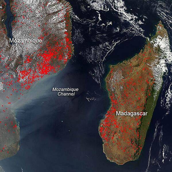
The location, widespread nature, and number of fires (outlined in red) in this satellite image suggest that these blazes were deliberately set to manage land. Farmers often use fire to return nutrients to the soil and to clear the ground of unwanted plants. While fire helps enhance crops and grasses for pasture, the fires also produce smoke that degrades air quality. In Mozambique and Madagascar, the growing season runs from the first rains in October-November. Thus, the clearing of lands in this early September image heralds the new growing season. Much of the once-green isle of Madagascar has been deforested via a combination of slash and burn agriculture for rice cultivation and doro-tanetry, a less intensive burning used to augment grass growth for cattle grazing. The fires mostly burn in grass or cropland, which is tan in this image. Photo courtesy of NASA.
The location, widespread nature, and number of fires (outlined in red) in this satellite image suggest that these blazes were deliberately set to manage land. Farmers often use fire to return nutrients to the soil and to clear the ground of unwanted plants. While fire helps enhance crops and grasses for pasture, the fires also produce smoke that degrades air quality. In Mozambique and Madagascar, the growing season runs from the first rains in October-November. Thus, the clearing of lands in this early September image heralds the new growing season. Much of the once-green isle of Madagascar has been deforested via a combination of slash and burn agriculture for rice cultivation and doro-tanetry, a less intensive burning used to augment grass growth for cattle grazing. The fires mostly burn in grass or cropland, which is tan in this image. Photo courtesy of NASA. • CIA World Factbook • 2020
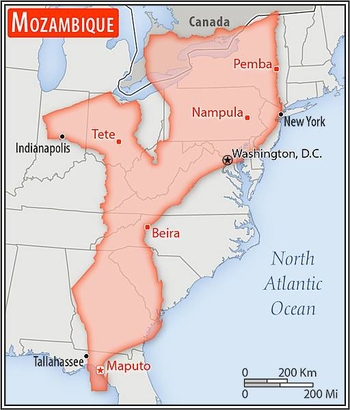
Area comparison map.
Area comparison map. • CIA World Factbook • 2020
2 photos available
Data sources: World Bank, UN Data • Updated daily •Learn about our data