›››
Namibia
Namibia
Population
3.0M
Rank #137Source: World Bank
Capital
Windhoek
Source: REST Countries
Region
Africa
Sub-Saharan Africa
Source: REST Countries
GDP (Nominal)
$13.37B
Rank #143Source: World Bank
Land Area
825.6K km²
Rank #34Source: REST Countries
Life Expectancy
67.385 yrs
Source: World Bank
Historical Trends
Population Trend (5-Year)
Source: World Bank
GDP Trend (5-Year, Nominal USD)
Source: World Bank
Geography
Area: 825,615 km²
Landlocked: No
Independent: Yes
Climate: desert; hot, dry; rainfall sparse and erratic
Terrain: mostly high plateau; Namib Desert along coast; Kalahari Desert in east
Elevation: mean elevation: 1,141 m lowest point: Atlantic Ocean 0 m highest point: Konigstein on Brandberg 2,573 m
Natural Hazards: prolonged periods of drought
Environmental Issues: depletion and degradation of water and aquatic resources; desertification; land degradation; loss of biodiversity and biotic resources; wildlife poaching
Land Use: agricultural land: 47.2% (2011 est.) forest: 8.8% (2011 est.) other: 44% (2011 est.)
Geography Note: the Namib Desert, after which the country is named, is considered to be the oldest desert in the world; Namibia is the first country in the world to incorporate the protection of the environment into...
Natural Resources
diamondscopperuraniumgoldsilverleadtinlithiumcadmiumtungsten
People & Society
Fertility Rate
3.21
Population
3.0M
Ethnic Groups
Ovambo (50%)Kavangos (9%)Herero (7%)Damara (7%)mixed European and African ancestry (6.5%)European (6%)Nama (5%)Caprivian (4%)San (3%)Baster (2%)Tswana (0.5%)
Religions
Christian 80% to 90% (at least (50%)indigenous beliefs 10% to (20%)
Economy
GDP per Capita
$4,413.128
GDP per Capita PPP
11,686.602
(2024)
(2024)
GNI per Capita
4,240
(2024)
(2024)
Gini Index
59.1
(2015)
(2015)
Unemployment
19.157%
(2024)
(2024)
Inflation
4.239%
(2024)
(2024)
Public Debt
4.668%
(2015)
(2015)
Energy
Electricity Access
56.7%
(2023)
(2023)
Renewable Energy
30%
(2021)
(2021)
CO₂ Emissions
3.65 Mt
(2024)
(2024)
Energy Intensity
3.45 MJ/$
(2021)
(2021)
Renewable Electricity
90.886%
(2021)
(2021)
Environment
Forest Coverage
7.805% of land
(2023)
(2023)
Communications
Internet Users
64.406%
(2023)
(2023)
Mobile Penetration
87.676%
(2023)
(2023)
Broadband Subscribers
3.52%
(2023)
(2023)
Transportation
Air Transport Freight
Not Available
Container Port Traffic
160,368 TEU
(2022)
(2022)
Airports
2,960
Rail Lines
N/A
Roads Total
N/A
Military
Military Forces
Namibian Defense Force (NDF): Army, Navy, Air Force; Namibian Police Force: Special Field Force (paramilitary unit responsible for protecting borders and government installations)
Personnel Strength
size assessments for the Namibian Defense Force (NDF) vary; approximately 13,000 personnel (11,000 Army; 1,000 Navy; 700 Air Force)
Military Expenditure (USD)
$0.36B
Military Expenditure (% of GDP)
2.73%
Military Expenditure History
3% of GDP (2019) 3.4% of GDP (2018) 3.6% of GDP (2017) 3.9% of GDP (2016) 4.5% of GDP (2015)
Equipment & Inventories
the inventory of the Namibian Defense Force consists mostly of Soviet-era equipment; China is the leading supplier of weapons to Namibia since 2010 (2019 est.)
Service Age & Obligation
18-25 years of age for voluntary military service; no conscription
Education
Pre-Primary Enrollment
36.507%
(2021)
(2021)
Primary Enrollment
120.719%
(2024)
(2024)
Secondary Enrollment
81.957%
(2024)
(2024)
Tertiary Enrollment
26.109%
(2022)
(2022)
Education Spending
9.084% of GDP
(2024)
(2024)
Adult Literacy Rate
87.64%
(2023)
(2023)
Pupil-Teacher Ratio
25.092:1
(2018)
(2018)
Health
Physicians per 1,000
0.553
(2022)
(2022)
Safe Water Access
86.509%
(2024)
(2024)
Safe Drinking Water
Not Available
Under-5 Mortality
40.7 per 1,000
(2023)
(2023)
Maternal Mortality (World Bank)
15.469 per 100,000
(2021)
(2021)
Hospital Beds per 1,000
57.269
(2021)
(2021)
UHC Coverage Index
66
(2023)
(2023)
Measles Immunization
74%
(2024)
(2024)
Social Indicators
Extreme Poverty Rate
22.9%
(2015)
(2015)
Food Insecurity
18.1%
(2023)
(2023)
Youth NEET Rate
37.959%
(2018)
(2018)
Governance
Women in Government
40.625%
(2024)
(2024)
Voice & Accountability
0.58
(Above Average)
(2023)
(Above Average)
(2023)
Political Stability
0.55
(Above Average)
(2023)
(Above Average)
(2023)
Government Effectiveness
0.03
(Above Average)
(2023)
(Above Average)
(2023)
Regulatory Quality
-0.06
(Below Average)
(2023)
(Below Average)
(2023)
Rule of Law
0.45
(Above Average)
(2023)
(Above Average)
(2023)
Control of Corruption
0.11
(Above Average)
(2023)
(Above Average)
(2023)
Government
Government Type
presidential republic
Legal System
mixed legal system of uncodified civil law based on Roman-Dutch law and customary law
Executive Branch
chief of state: President Hage GEINGOB (since 21 March 2015); Vice President Nangola MBUMBA (since 8 February 2018); note - the president is both chief of state and head of government head of...
Legislative Branch
description: bicameral Parliament consists of:National Council (42 seats); members indirectly elected 3 each by the 14 regional councils to serve 5-year terms); note - the Council primarily reviews...
Judicial Branch
highest courts: Supreme Court (consists of the chief justice and at least 3 judges in quorum sessions) judge selection and term of office: judges appointed by the president of Namibia upon the...
International Organizations
National Symbols
Flag Description
a wide red stripe edged by narrow white stripes divides the flag diagonally from lower hoist corner to upper fly corner; the upper hoist-side triangle is blue and charged with a golden-yellow,...
National Symbols
oryx (antelope); national colors: blue, red, green, white, yellow
National Anthem
name: Namibia, Land of the Brave lyrics/music: Axali DOESEB note: adopted 1991
Safety
Homicide Rate
11.208 per 100,000
(2021)
(2021)
Travel Information
Language(s): Afrikaans, German, English, +6 more
Currency: NAD ($), ZAR (R)
Timezone(s): UTC+01:00
Landlocked: No
Independent: Yes
Driving Side: Left
Calling Code: +264
Car Sign: NAM
Week Starts: Monday
Photos
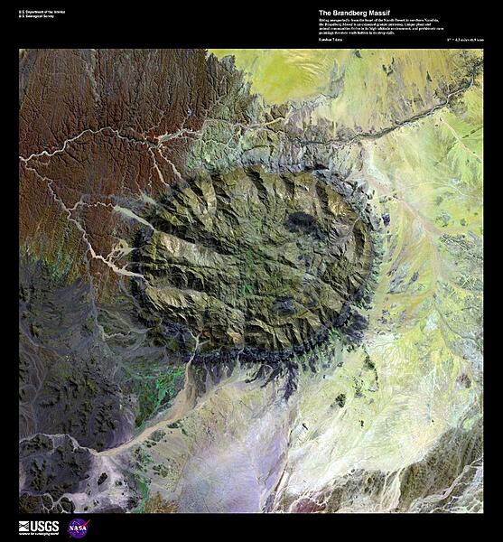
Rising unexpectedly from the heart of the Namib Desert, the Brandberg Massif, shown in this enhanced satellite image, is an exhumed granitic intrusion. As one of the highest mountains in Namibia at 2,573 m (8,439 ft), it formed when ancient magma chambers cooled and began to erode. Brandberg means fire mountain in Africaans, Dutch, and German. Unique plant and animal communities thrive in Brandberg's high-altitude environment, and prehistoric cave paintings decorate walls hidden in its steep cliffs, earning it status as a potential UNESCO World Heritage site. Image courtesy of USGS.
Rising unexpectedly from the heart of the Namib Desert, the Brandberg Massif, shown in this enhanced satellite image, is an exhumed granitic intrusion. As one of the highest mountains in Namibia at 2,573 m (8,439 ft), it formed when ancient magma chambers cooled and began to erode. Brandberg means fire mountain in Africaans, Dutch, and German. Unique plant and animal communities thrive in Brandberg's high-altitude environment, and prehistoric cave paintings decorate walls hidden in its steep cliffs, earning it status as a potential UNESCO World Heritage site. Image courtesy of USGS. • CIA World Factbook • 2020
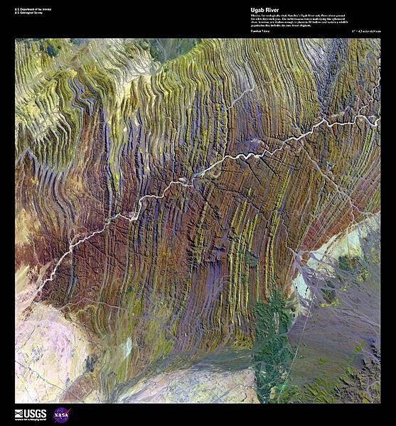
Elusive, but ecologically vital, the 500 km (310 mi) Ugab River only flows above ground for a few days each year. Shown in this false-color satellite image, the subterranean waters underlying this ephemeral river are shallow enough in places to fill hollows and sustain wildlife populations that include the rare desert elephant and the largest free population of black rhino. Pink-granite inselbergs, islands of rock left behind after volcanic activity, form bizarre sculptures in the sandy riverbed. Some, known as "petrified ghosts," are eerie hollow structures, carved by erosion. Image courtesy of USGS.
Elusive, but ecologically vital, the 500 km (310 mi) Ugab River only flows above ground for a few days each year. Shown in this false-color satellite image, the subterranean waters underlying this ephemeral river are shallow enough in places to fill hollows and sustain wildlife populations that include the rare desert elephant and the largest free population of black rhino. Pink-granite inselbergs, islands of rock left behind after volcanic activity, form bizarre sculptures in the sandy riverbed. Some, known as "petrified ghosts," are eerie hollow structures, carved by erosion. Image courtesy of USGS. • CIA World Factbook • 2020
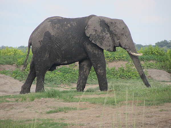
A bathed and refreshed elephant on the banks of the Chobe River.
A bathed and refreshed elephant on the banks of the Chobe River. • CIA World Factbook • 2020
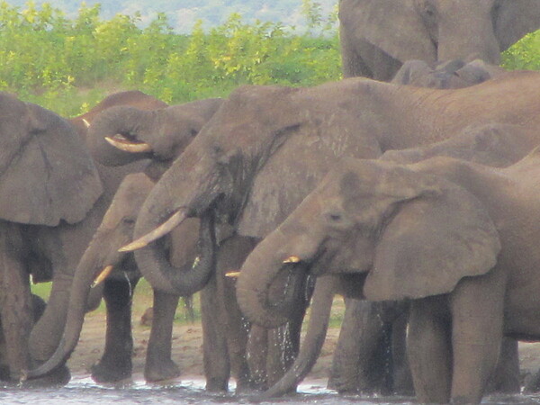
Thirsty elephants along the Chobe River.
Thirsty elephants along the Chobe River. • CIA World Factbook • 2020
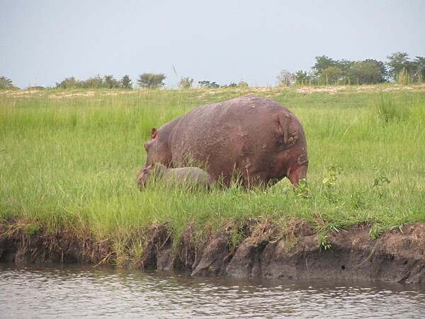
Hippopotamus and her calf along the Chobe River.
Hippopotamus and her calf along the Chobe River. • CIA World Factbook • 2020
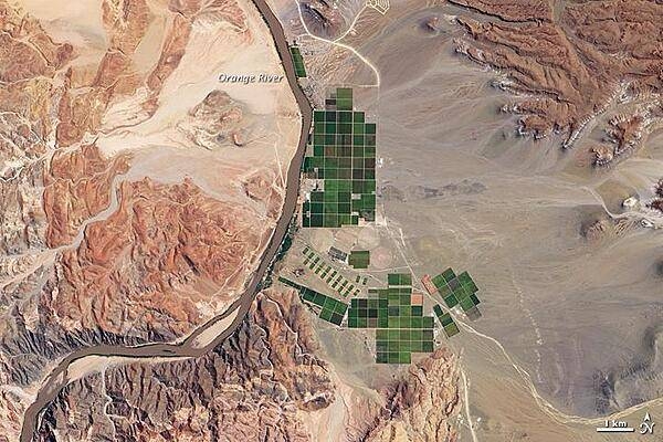
The Orange River serves as part of the border between Namibia and the Republic of South Africa. Along the banks of this river, roughly 100 km (60 mi) inland from where the river empties into the Atlantic Ocean, irrigation projects take advantage of water from the river and soils from the floodplains to grow produce, turning parts of a normally earth-toned landscape emerald green. A network of bright rectangles of varying shades of green contrasts with surroundings of gray, beige, tan, and rust in this true-color satellite image. Immediately south of a large collection of irrigated plots, faint beige circles reveal center-pivot irrigation fields, apparently allowed to go fallow. This Namibian irrigation project occurs along a section of the Orange River where the waterway turns north on its general westward path to the sea, not far from the eastern margin of the Namib Desert. Due to local climatic conditions, grapes from Namibia, the primary agricultural product of this area, are often ready for market two to three weeks before those of the main grape-producing regions of South Africa's Cape. Image courtesy of NASA.
The Orange River serves as part of the border between Namibia and the Republic of South Africa. Along the banks of this river, roughly 100 km (60 mi) inland from where the river empties into the Atlantic Ocean, irrigation projects take advantage of water from the river and soils from the floodplains to grow produce, turning parts of a normally earth-toned landscape emerald green. A network of bright rectangles of varying shades of green contrasts with surroundings of gray, beige, tan, and rust in this true-color satellite image. Immediately south of a large collection of irrigated plots, faint beige circles reveal center-pivot irrigation fields, apparently allowed to go fallow. This Namibian irrigation project occurs along a section of the Orange River where the waterway turns north on its general westward path to the sea, not far from the eastern margin of the Namib Desert. Due to local climatic conditions, grapes from Namibia, the primary agricultural product of this area, are often ready for market two to three weeks before those of the main grape-producing regions of South Africa's Cape. Image courtesy of NASA. • CIA World Factbook • 2020
14 photos available
View All Photos→Data sources: World Bank, UN Data • Updated daily •Learn about our data