›››
Papua New Guinea
Papua New Guinea
Population
10.6M
Rank #91Source: World Bank
Capital
Port Moresby
Source: REST Countries
Region
Oceania
East Asia & Pacific
Source: REST Countries
GDP (Nominal)
$31.80B
Rank #110Source: World Bank
Land Area
462.8K km²
Rank #55Source: REST Countries
Life Expectancy
66.134 yrs
Source: World Bank
Historical Trends
Population Trend (5-Year)
Source: World Bank
GDP Trend (5-Year, Nominal USD)
Source: World Bank
Geography
Area: 462,840 km²
Landlocked: No
Independent: Yes
Climate: tropical; northwest monsoon (December to March), southeast monsoon (May to October); slight seasonal temperature variation
Terrain: mostly mountains with coastal lowlands and rolling foothills
Elevation: mean elevation: 667 m lowest point: Pacific Ocean 0 m highest point: Mount Wilhelm 4,509 m
Natural Hazards: active volcanism; the country is subject to frequent and sometimes severe earthquakes; mud slides; tsunamisvolcanism: severe volcanic activity; Ulawun (2,334 m), one of Papua New Guinea's potentially...
Environmental Issues: rain forest loss as a result of growing commercial demand for tropical timber; unsustainable logging practices result in soil erosion, water quality degredation, and loss of habitat and biodiversity;...
Land Use: agricultural land: 2.6% (2011 est.) forest: 63.1% (2011 est.) other: 34.3% (2011 est.)
Geography Note: note 1: shares island of New Guinea with Indonesia; generally east-west trending highlands break up New Guinea into diverse ecoregions; one of world's largest swamps along southwest coast note 2:...
Natural Resources
goldcoppersilvernatural gastimberoilfisheries
People & Society
Fertility Rate
3.10
Population
10.6M
Religions
Protestant 64.3% (Evangelical Lutheran (18.4%)Seventh Day Adventist (12.9%)Pentecostal (10.4%)United Church (10.3%)Evangelical Alliance (5.9%)Anglican (3.2%)Baptist (2.8%)Salvation Army (0.4%)Roman Catholic (26%)other Christian (5.3%)non-Christian (1.4%)unspecified 3.1%
note: data represent only the citizen population; roughly (0.3%)consisting of Christian (52%)other (10.7%)none (37.3%)
Economy
GDP per Capita
$3,006.706
GDP per Capita PPP
4,874.69
(2024)
(2024)
GNI per Capita
2,900
(2024)
(2024)
Gini Index
Not Available
Unemployment
2.625%
(2024)
(2024)
Inflation
0.602%
(2024)
(2024)
Public Debt
52.381%
(2023)
(2023)
Energy
Electricity Access
20.5%
(2023)
(2023)
Renewable Energy
54.6%
(2022)
(2022)
CO₂ Emissions
5.468 Mt
(2024)
(2024)
Energy Intensity
6.47 MJ/$
(2022)
(2022)
Renewable Electricity
39.959%
(2021)
(2021)
Environment
Forest Coverage
78.954% of land
(2023)
(2023)
Protected Areas
1.37% of land
(2009)
(2009)
Communications
Internet Users
24.067%
(2023)
(2023)
Mobile Penetration
34.059%
(2023)
(2023)
Broadband Subscribers
0.215%
(2022)
(2022)
Transportation
Air Transport Freight
7.121 M ton-km
(2023)
(2023)
Container Port Traffic
204,518 TEU
(2020)
(2020)
Airports
34,416
Rail Lines
N/A
Roads Total
N/A
Military
Military Forces
Papua New Guinea Defense Force (PNGDF, includes land, maritime, and air elements)
Personnel Strength
the Papau New Guinea Defense Force has approximately 3,000 active duty troops (2,700 Ground; 200 Maritime; 100 Air)
Military Expenditure (USD)
$0.09B
Military Expenditure (% of GDP)
0.31%
Military Expenditure History
0.4% of GDP (2019) 0.4% of GDP (2018) 0.4% of GDP (2017) 0.4% of GDP (2016) 0.5% of GDP (2015)
Equipment & Inventories
the PNGDF has a limited inventory consisting of a diverse mix of foreign-supplied weapons and equipment; Papau New Guinea receives most of its military assistance from Australia; since 2010, it has...
Service Age & Obligation
16 years of age for voluntary military service (with parental consent); no conscription; graduation from grade 12 required
Education
Pre-Primary Enrollment
45.845%
(2018)
(2018)
Primary Enrollment
121.09%
(2023)
(2023)
Secondary Enrollment
52.093%
(2023)
(2023)
Tertiary Enrollment
Not Available
Education Spending
0.782% of GDP
(2023)
(2023)
Adult Literacy Rate
87.144%
(2022)
(2022)
Pupil-Teacher Ratio
35.522:1
(2016)
(2016)
Health
Physicians per 1,000
0.061
(2023)
(2023)
Safe Water Access
53.298%
(2024)
(2024)
Safe Drinking Water
Not Available
Under-5 Mortality
40.3 per 1,000
(2023)
(2023)
Maternal Mortality (World Bank)
16.432 per 100,000
(2021)
(2021)
Hospital Beds per 1,000
65.488
(2021)
(2021)
UHC Coverage Index
32
(2023)
(2023)
Measles Immunization
42%
(2024)
(2024)
Social Indicators
Extreme Poverty Rate
Not Available
Food Insecurity
28.7%
(2023)
(2023)
Youth NEET Rate
3.79%
(2022)
(2022)
Governance
Women in Government
2.703%
(2024)
(2024)
Voice & Accountability
0.01
(Above Average)
(2023)
(Above Average)
(2023)
Political Stability
-0.48
(Below Average)
(2023)
(Below Average)
(2023)
Government Effectiveness
-0.80
(Below Average)
(2023)
(Below Average)
(2023)
Regulatory Quality
-0.64
(Below Average)
(2023)
(Below Average)
(2023)
Rule of Law
-0.54
(Below Average)
(2023)
(Below Average)
(2023)
Control of Corruption
-0.66
(Below Average)
(2023)
(Below Average)
(2023)
Government
Government Type
parliamentary democracy under a constitutional monarchy; a Commonwealth realm
Legal System
mixed legal system of English common law and customary law
Executive Branch
chief of state: Queen ELIZABETH II (since 6 February 1952); represented by Governor General Grand Chief Sir Bob DADAE (since 28 February 2017) head of government: Prime Minister James MARAPE (since...
Legislative Branch
description: unicameral National Parliament (111 seats; members directly elected in single-seat constituencies - 89 local, 20 provinicial, the autonomous province of Bouganville, and the National...
Judicial Branch
highest courts: Supreme Court (consists of the chief justice, deputy chief justice, 35 justices, and 5 acting justices); National Courts (consists of 13 courts located in the provincial capitals,...
International Organizations
National Symbols
Flag Description
divided diagonally from upper hoist-side corner; the upper triangle is red with a soaring yellow bird of paradise centered; the lower triangle is black with five, white, five-pointed stars of the...
National Symbols
bird of paradise; national colors: red, black
National Anthem
name: O Arise All You Sons lyrics/music: Thomas SHACKLADY note: adopted 1975
Travel Information
Language(s): English, Hiri Motu, Tok Pisin
Currency: PGK (K)
Timezone(s): UTC+10:00
Landlocked: No
Independent: Yes
Driving Side: Left
Calling Code: +675
Car Sign: PNG
Week Starts: Monday
Photos

Although Bouganville Island is geographically part of the Solomon Islands chain, politically, the island is part of Papua New Guinea. Bouganville is typical of many Pacific Rim islands in that volcanism has played a large part in both its geological and recorded history. The island hosts three large volcanoes along its northwest-southeast trending axis: Mount Balbi, Mount Bagana, and the Mount Takuan volcanic complex. Mount Bagana, located near image center in this astronaut photograph, is the only historically active volcano on the island. Within Bouganville's lush landscape, light green vegetation and brown lava flows mark the 1,750-meter-high lava cone of Mount Bagana. The lighter color of vegetation could result from volcanic activity, higher altitude, or both. The eruptive style of the volcano is typically non-explosive, producing thick lobes of lava that run down the flanks and maintain a dome in the summit crater. Occasional pyroclastic flows of rock fragments and volcanic ash have also occurred. This image shows a diffuse white vapor plume extending west-southwest from the summit. Photo courtesy of NASA.
Although Bouganville Island is geographically part of the Solomon Islands chain, politically, the island is part of Papua New Guinea. Bouganville is typical of many Pacific Rim islands in that volcanism has played a large part in both its geological and recorded history. The island hosts three large volcanoes along its northwest-southeast trending axis: Mount Balbi, Mount Bagana, and the Mount Takuan volcanic complex. Mount Bagana, located near image center in this astronaut photograph, is the only historically active volcano on the island.
Within Bouganville's lush landscape, light green vegetation and brown lava flows mark the 1,750-meter-high lava cone of Mount Bagana. The lighter color of vegetation could result from volcanic activity, higher altitude, or both. The eruptive style of the volcano is typically non-explosive, producing thick lobes of lava that run down the flanks and maintain a dome in the summit crater. Occasional pyroclastic flows of rock fragments and volcanic ash have also occurred. This image shows a diffuse white vapor plume extending west-southwest from the summit. Photo courtesy of NASA. • CIA World Factbook • 2020
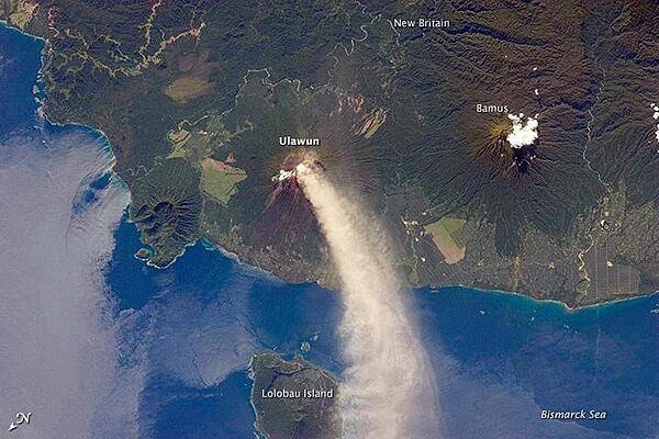
Numerous volcanoes contribute to the landmass of the island of New Britain, the largest in the Bismarck Archipelago of Papua New Guinea. One of the most active of these volcanoes - Ulawun - is also the tallest, with a summit elevation of 2,334 m (7,657 ft). This astronaut photograph shows a plume of white steam and ash extending from the summit crater of the stratovolcano towards the northwest. The plume begins to broaden as it passes the southwestern coast of Lolobau Island, approximately 23 km downwind. Note that north is towards the lower left. Ulawun is also known as "the Father," with the Bamus volcano to the southwest also known as "the South Son." The summit of Bamus is obscured by white cumulus clouds (not of volcanic origin) in this image. While Ulawun has been active since at least 1700, the most recent activity at Bamus occurred in the late 19th century. A large region of ocean surface highlighted by sunglint - sunlight reflecting off the water surface - is visible to the north-northeast of Ulawun. Photo courtesy of NASA.
Numerous volcanoes contribute to the landmass of the island of New Britain, the largest in the Bismarck Archipelago of Papua New Guinea. One of the most active of these volcanoes - Ulawun - is also the tallest, with a summit elevation of 2,334 m (7,657 ft).
This astronaut photograph shows a plume of white steam and ash extending from the summit crater of the stratovolcano towards the northwest. The plume begins to broaden as it passes the southwestern coast of Lolobau Island, approximately 23 km downwind. Note that north is towards the lower left.
Ulawun is also known as "the Father," with the Bamus volcano to the southwest also known as "the South Son." The summit of Bamus is obscured by white cumulus clouds (not of volcanic origin) in this image. While Ulawun has been active since at least 1700, the most recent activity at Bamus occurred in the late 19th century. A large region of ocean surface highlighted by sunglint - sunlight reflecting off the water surface - is visible to the north-northeast of Ulawun. Photo courtesy of NASA. • CIA World Factbook • 2020
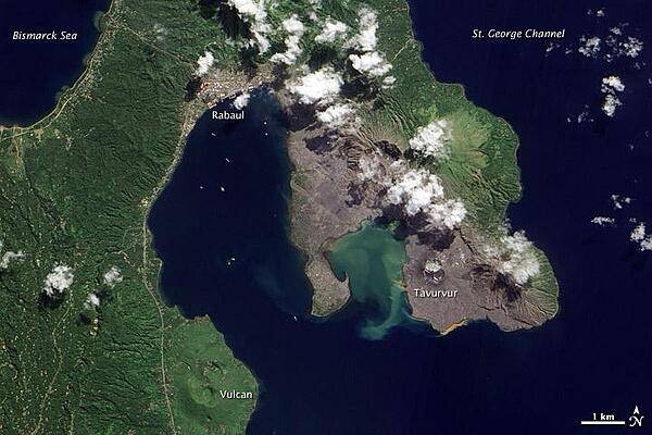
Volcanic cones and settlements mingle along the margins of the Rabaul Caldera on the northeastern tip of Papua New Guinea's New Britain Island. Shaped like a giant cauldron, the caldera is the remaining rim of an ancient volcano. Small volcanic cones, some of which are still active, sit on the rim. Spanning roughly 8 by 14 km (5 by 9 mi), the caldera is flooded by Blanche Bay. The largely submerged caldera long formed a natural harbor for what had been New Britain's largest city, but a major eruption forced the evacuation of Rabaul City in 1994. Although the city ceased to bustle with activity, at least one volcanic cone remained active for years afterward. The landscape in this satellite image appears as a mixture of vegetated and bare ground. Vegetation almost completely coats the western side of Rabaul Caldera. Volcanic cones line the northeastern margin of the caldera, and around these cones, the land is mostly rocky and barren. Tavurvur, near the southern end of the exposed caldera rim, was one of the volcanoes to erupt explosively in 1994. The other was Vulcan, on the western side of the caldera. While vegetation has revived on the slopes of Vulcan, rocks predominate at Tavurvur, evidence of more recent eruptive activity. Remnants of settlements linger along the caldera's northwestern margin and on a promontory near the caldera's center. Prior to the explosive eruption in 1994, the city of Rabaul had been the provincial capital of East New Britain. After the eruption, the capital was moved to the coastal city of Kokopo, some 20 km (12 mi) to the southeast. Photo courtesy of NASA.
Volcanic cones and settlements mingle along the margins of the Rabaul Caldera on the northeastern tip of Papua New Guinea's New Britain Island. Shaped like a giant cauldron, the caldera is the remaining rim of an ancient volcano. Small volcanic cones, some of which are still active, sit on the rim. Spanning roughly 8 by 14 km (5 by 9 mi), the caldera is flooded by Blanche Bay. The largely submerged caldera long formed a natural harbor for what had been New Britain's largest city, but a major eruption forced the evacuation of Rabaul City in 1994. Although the city ceased to bustle with activity, at least one volcanic cone remained active for years afterward.
The landscape in this satellite image appears as a mixture of vegetated and bare ground. Vegetation almost completely coats the western side of Rabaul Caldera. Volcanic cones line the northeastern margin of the caldera, and around these cones, the land is mostly rocky and barren.
Tavurvur, near the southern end of the exposed caldera rim, was one of the volcanoes to erupt explosively in 1994. The other was Vulcan, on the western side of the caldera. While vegetation has revived on the slopes of Vulcan, rocks predominate at Tavurvur, evidence of more recent eruptive activity.
Remnants of settlements linger along the caldera's northwestern margin and on a promontory near the caldera's center. Prior to the explosive eruption in 1994, the city of Rabaul had been the provincial capital of East New Britain. After the eruption, the capital was moved to the coastal city of Kokopo, some 20 km (12 mi) to the southeast. Photo courtesy of NASA. • CIA World Factbook • 2020
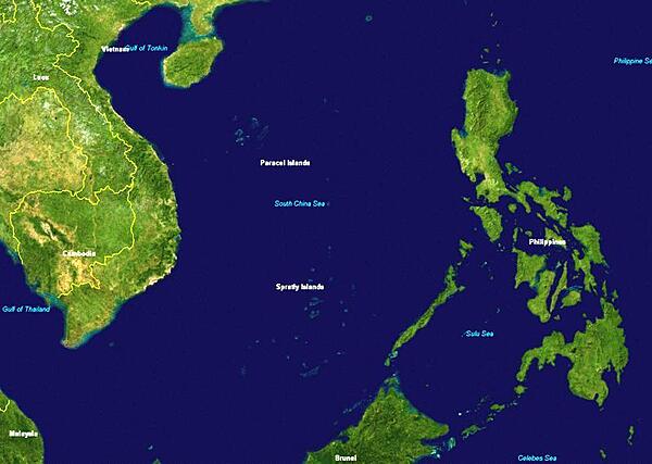
Satellite view of the western Pacific Ocean and the South China Sea shows the location of the Spratly Islands between Vietnam and the Philippines. Image courtesy of NASA.
Satellite view of the western Pacific Ocean and the South China Sea shows the location of the Spratly Islands between Vietnam and the Philippines. Image courtesy of NASA. • CIA World Factbook • 2020
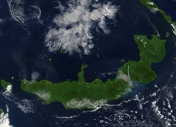
NASA's Terra satellite captured this image of "the troublesome trio" on Papua New Guinea's New Britain island when they erupted simultaneously on 9 August 2005. Langila, Ulawun, and Rabaul Volcanoes all spewed ash at the same time, though not all with the same results. The westernmost volcano, Langila, and the easternmost volcano, Rabaul, sent fairly faint plumes of ash into the air, both of which drifted toward the northwest. Ulawun, the most active volcano in this picture, spit out a dense stream of ash that flew straight south. The volcanoes' proximity to each other and propensity for acting up at the same time suggest that they could be affected by the same tectonic activity underground. Photo courtesy of NASA.
NASA's Terra satellite captured this image of "the troublesome trio" on Papua New Guinea's New Britain island when they erupted simultaneously on 9 August 2005. Langila, Ulawun, and Rabaul Volcanoes all spewed ash at the same time, though not all with the same results. The westernmost volcano, Langila, and the easternmost volcano, Rabaul, sent fairly faint plumes of ash into the air, both of which drifted toward the northwest. Ulawun, the most active volcano in this picture, spit out a dense stream of ash that flew straight south. The volcanoes' proximity to each other and propensity for acting up at the same time suggest that they could be affected by the same tectonic activity underground. Photo courtesy of NASA. • CIA World Factbook • 2020
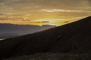
As part of a multinational training exercise, US Marines and US Sailors, Australian soldiers, and British soldiers hike a hill along the Kokoda Track in Papua New Guinea in 2015. The exercise was designed to provide assistance to Papua New Guinea through infrastructure rehabilitation and basic military training. Photo courtesy of the US Marine Corps/ Cpl. William Hester.
As part of a multinational training exercise, US Marines and US Sailors, Australian soldiers, and British soldiers hike a hill along the Kokoda Track in Papua New Guinea in 2015. The exercise was designed to provide assistance to Papua New Guinea through infrastructure rehabilitation and basic military training. Photo courtesy of the US Marine Corps/ Cpl. William Hester. • CIA World Factbook • 2020
12 photos available
View All Photos→Data sources: World Bank, UN Data • Updated daily •Learn about our data