›››
Palau
Palau
Population
17.7K
Rank #215Source: World Bank
Capital
Koror
Source: REST Countries
Region
Oceania
East Asia & Pacific
Source: REST Countries
GDP (Nominal)
$276.73M
Source: World Bank
Land Area
459 km²
Rank #191Source: REST Countries
Life Expectancy
69.269 yrs
Source: World Bank
Historical Trends
Population Trend (5-Year)
Source: World Bank
GDP Trend (5-Year, Nominal USD)
Source: World Bank
Geography
Area: 459 km²
Landlocked: No
Independent: Yes
Climate: tropical; hot and humid; wet season May to November
Terrain: varying topography from the high, mountainous main island of Babelthuap to low, coral islands usually fringed by large barrier reefs
Elevation: lowest point: Pacific Ocean 0 m highest point: Mount Ngerchelchuus 242 m
Natural Hazards: typhoons (June to December)
Environmental Issues: inadequate facilities for disposal of solid waste; threats to the marine ecosystem from sand and coral dredging, illegal and destructive fishing practices, and overfishing; climate change contributes...
Land Use: agricultural land: 10.8% (2011 est.) forest: 87.6% (2011 est.) other: 1.6% (2011 est.)
Geography Note: westernmost archipelago in the Caroline chain, consists of six island groups totaling more than 300 islands; includes World War II battleground of Beliliou (Peleliu) and world-famous Rock Islands
Natural Resources
forestsminerals (especially gold)marine productsdeep-seabed minerals
People & Society
Fertility Rate
1.91
Population
17.7K
Ethnic Groups
Palauan (Micronesian with Malayan and Melanesian admixtures) (73%)Carolinian (2%)Asian (21.7%)caucasian (1.2%)other (2.1%)
Religions
Roman Catholic (45.3%)Protestant 34.9% (includes Evangelical (26.4%)Seventh Day Adventist (6.9%)Assembly of God (0.9%)Baptist (0.7%)Modekngei (5.7%)Muslim (3%)Mormon (1.5%)other (9.7%)
Economy
GDP per Capita
$15,610.823
GDP per Capita PPP
18,230.27
(2023)
(2023)
GNI per Capita
14,780
(2023)
(2023)
Gini Index
Not Available
Unemployment
Not Available
Inflation
2.232%
(2024)
(2024)
Public Debt
85.172%
(2019)
(2019)
Energy
Electricity Access
100%
(2023)
(2023)
Renewable Energy
0.9%
(2022)
(2022)
CO₂ Emissions
1.466 Mt
(2024)
(2024)
Energy Intensity
13.8 MJ/$
(2022)
(2022)
Renewable Electricity
4.598%
(2021)
(2021)
Environment
Forest Coverage
90.543% of land
(2023)
(2023)
Protected Areas
4.8% of land
(2009)
(2009)
Communications
Internet Users
Not Available
Mobile Penetration
135.387%
(2023)
(2023)
Broadband Subscribers
7.333%
(2023)
(2023)
Transportation
Air Transport Freight
Not Available
Container Port Traffic
16,399 TEU
(2019)
(2019)
Airports
N/A
Rail Lines
N/A
Roads Total
N/A
Military
Military Forces
no regular military forces; the Ministry of Justice includes divisions/bureaus for public security, police functions, and maritime law enforcement.
Equipment & Inventories
since 2018, Australia and Japan have provided patrol boats to the Palau's Division of Marine Law Enforcement (2020)
Education
Pre-Primary Enrollment
70.509%
(2020)
(2020)
Primary Enrollment
100.719%
(2023)
(2023)
Secondary Enrollment
97.286%
(2023)
(2023)
Tertiary Enrollment
41.131%
(2023)
(2023)
Education Spending
3.526% of GDP
(2023)
(2023)
Adult Literacy Rate
100%
(2020)
(2020)
Pupil-Teacher Ratio
Not Available
Health
Physicians per 1,000
1.808
(2023)
(2023)
Safe Water Access
99.532%
(2024)
(2024)
Safe Drinking Water
90.775%
(2024)
(2024)
Under-5 Mortality
22.3 per 1,000
(2023)
(2023)
Maternal Mortality (World Bank)
89 per 100,000
(2023)
(2023)
UHC Coverage Index
75
(2023)
(2023)
Measles Immunization
97%
(2024)
(2024)
Social Indicators
Extreme Poverty Rate
Not Available
Food Insecurity
Not Available
Youth NEET Rate
4.745%
(2023)
(2023)
Governance
Women in Government
25%
(2024)
(2024)
Voice & Accountability
1.08
(Strong)
(2023)
(Strong)
(2023)
Political Stability
1.08
(Strong)
(2023)
(Strong)
(2023)
Government Effectiveness
0.44
(Above Average)
(2023)
(Above Average)
(2023)
Regulatory Quality
0.40
(Above Average)
(2023)
(Above Average)
(2023)
Rule of Law
0.94
(Above Average)
(2023)
(Above Average)
(2023)
Control of Corruption
0.59
(Above Average)
(2023)
(Above Average)
(2023)
Government
Government Type
presidential republic in free association with the US
Legal System
mixed legal system of civil, common, and customary law
Executive Branch
chief of state: President Tommy REMENGESAU (since 17 January 2013); Vice President Raynold OILUCH (since 19 January 2017); note - the president is both chief of state and head of government head of...
Legislative Branch
description: bicameral National Congress or Olbiil Era Kelulau consists of:Senate (13 seats; members directly elected in single-seat constituencies by majority vote to serve 4-year terms)House of...
Judicial Branch
highest courts: Supreme Court (consists of the chief justice and 3 associate justices organized into appellate trial divisions; the Supreme Court organization also includes the Common Pleas and Land...
National Symbols
Flag Description
light blue with a large yellow disk shifted slightly to the hoist side; the blue color represents the ocean, the disk represents the moon; Palauans consider the full moon to be the optimum time for...
National Symbols
bai (native meeting house); national colors: blue, yellow
National Anthem
name: "Belau rekid" (Our Palau) lyrics/music: multiple/Ymesei O. EZEKIEL note: adopted 1980
Safety
Homicide Rate
11.227 per 100,000
(2018)
(2018)
Travel Information
Language(s): English, Palauan
Currency: USD ($)
Timezone(s): UTC+09:00
Landlocked: No
Independent: Yes
Driving Side: Right
Calling Code: +680
Car Sign: PAL
Week Starts: Monday
Photos
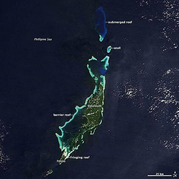
The Republic of Palau, a chain of islands at the far western end of Micronesia, consists of nine inhabited islands and more than 700 small islets in the Philippine Sea. The archipelago contains a range of geological features but, when viewed from above, it is the archipelago's many turquoise coral reefs that command attention. The island chain is comprised of 459 sq km (179 sq mi) of dry land, and approximately 525 sq km (203 sq mi) of reefs spread through the ocean. NASA's Terra satellite acquired this view of Palau on 11 December 2012. Image courtesy of NASA.
The Republic of Palau, a chain of islands at the far western end of Micronesia, consists of nine inhabited islands and more than 700 small islets in the Philippine Sea. The archipelago contains a range of geological features but, when viewed from above, it is the archipelago's many turquoise coral reefs that command attention. The island chain is comprised of 459 sq km (179 sq mi) of dry land, and approximately 525 sq km (203 sq mi) of reefs spread through the ocean. NASA's Terra satellite acquired this view of Palau on 11 December 2012. Image courtesy of NASA. • CIA World Factbook • 2020
CIA World Factbook • 2020
CIA World Factbook • 2020
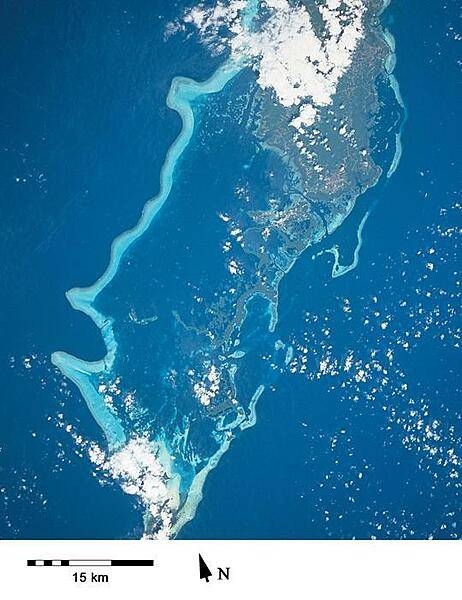
Another space-based view of Palau showing the southern portion of Babeldaob Island (top) and various islands to its south ending in Peleliu (bottom), the site of a fierce World War II battle. (Image courtesy of NASA.)
Another space-based view of Palau showing the southern portion of Babeldaob Island (top) and various islands to its south ending in Peleliu (bottom), the site of a fierce World War II battle. (Image courtesy of NASA.) • CIA World Factbook • 2020
4 photos available
Data sources: World Bank, UN Data • Updated daily •Learn about our data