›››
Tajikistan
Tajikistan
Population
10.6M
Rank #90Source: World Bank
Capital
Dushanbe
Source: REST Countries
Region
Europe
Europe & Central Asia
Source: REST Countries
GDP (Nominal)
$14.20B
Rank #141Source: World Bank
Land Area
143.1K km²
Rank #95Source: REST Countries
Life Expectancy
71.79 yrs
Source: World Bank
Historical Trends
Population Trend (5-Year)
Source: World Bank
GDP Trend (5-Year, Nominal USD)
Source: World Bank
People & Society
Fertility Rate
3.07
Population
10.6M
Economy
GDP per Capita
$1,341.202
GDP per Capita PPP
5,405.98
(2024)
(2024)
GNI per Capita
1,650
(2024)
(2024)
Gini Index
36.1
(2024)
(2024)
Unemployment
7.041%
(2024)
(2024)
Inflation
6.005%
(2016)
(2016)
Public Debt
Not Available
Energy
Electricity Access
100%
(2023)
(2023)
Renewable Energy
34.9%
(2021)
(2021)
CO₂ Emissions
9.77 Mt
(2024)
(2024)
Energy Intensity
4.03 MJ/$
(2021)
(2021)
Renewable Electricity
93.383%
(2021)
(2021)
Environment
Forest Coverage
3.075% of land
(2023)
(2023)
Communications
Internet Users
56.791%
(2023)
(2023)
Mobile Penetration
126.161%
(2022)
(2022)
Broadband Subscribers
0.061%
(2022)
(2022)
Transportation
Air Transport Freight
131.735 M ton-km
(2023)
(2023)
Container Port Traffic
Not Available
Airports
5,341
Rail Lines
620 km
Roads Total
N/A
Military
Military Expenditure (USD)
$0.25B
Military Expenditure (% of GDP)
1.85%
Education
Pre-Primary Enrollment
9.914%
(2017)
(2017)
Primary Enrollment
95.757%
(2024)
(2024)
Secondary Enrollment
86.904%
(2024)
(2024)
Tertiary Enrollment
35.64%
(2024)
(2024)
Education Spending
5.437% of GDP
(2023)
(2023)
Pupil-Teacher Ratio
22.301:1
(2017)
(2017)
Health
Physicians per 1,000
1.87
(2023)
(2023)
Safe Water Access
89.191%
(2024)
(2024)
Safe Drinking Water
65.108%
(2024)
(2024)
Under-5 Mortality
27.3 per 1,000
(2023)
(2023)
Maternal Mortality (World Bank)
17.759 per 100,000
(2021)
(2021)
Hospital Beds per 1,000
71.815
(2021)
(2021)
UHC Coverage Index
72
(2023)
(2023)
Measles Immunization
97%
(2024)
(2024)
Social Indicators
Extreme Poverty Rate
6.1%
(2024)
(2024)
Food Insecurity
8.4%
(2023)
(2023)
Youth NEET Rate
Not Available
Governance
Women in Government
26.984%
(2024)
(2024)
Voice & Accountability
-1.64
(Weak)
(2023)
(Weak)
(2023)
Political Stability
-0.47
(Below Average)
(2023)
(Below Average)
(2023)
Government Effectiveness
-0.77
(Below Average)
(2023)
(Below Average)
(2023)
Regulatory Quality
-1.18
(Weak)
(2023)
(Weak)
(2023)
Rule of Law
-1.28
(Weak)
(2023)
(Weak)
(2023)
Control of Corruption
-1.38
(Weak)
(2023)
(Weak)
(2023)
Government
National Symbols
Safety
Homicide Rate
0.892 per 100,000
(2020)
(2020)
Travel Information
Language(s): Russian, Tajik
Currency: TJS (ЅМ)
Timezone(s): UTC+05:00
Landlocked: Yes
Independent: Yes
Driving Side: Right
Calling Code: +992
Car Sign: TJ
Week Starts: Monday
Photos
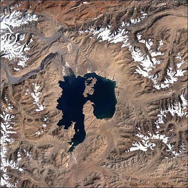
Near the center of this scene is the mountain lake Kara-Kul, located in eastern Tajikistan, high in the Pamir Mountain Range near the Afghan border. The 25-km (16-mi) diameter lake sits at an elevation of about 4,000 m (about 12,000 ft) above sea level. Kara-Kul was formed from a meteorite impact approximately 25 million years ago, leaving a crater with a rim diameter of 45 km (28 mi). Islands formed from the central uplift can be seen in the northern and southern parts of the lake. Interestingly, the Kara-Kul impact structure remained unidentified until it was discovered though studies of imagery taken from space. Photo courtesy of NASA.
Near the center of this scene is the mountain lake Kara-Kul, located in eastern Tajikistan, high in the Pamir Mountain Range near the Afghan border. The 25-km (16-mi) diameter lake sits at an elevation of about 4,000 m (about 12,000 ft) above sea level. Kara-Kul was formed from a meteorite impact approximately 25 million years ago, leaving a crater with a rim diameter of 45 km (28 mi). Islands formed from the central uplift can be seen in the northern and southern parts of the lake. Interestingly, the Kara-Kul impact structure remained unidentified until it was discovered though studies of imagery taken from space. Photo courtesy of NASA. • CIA World Factbook • 2020
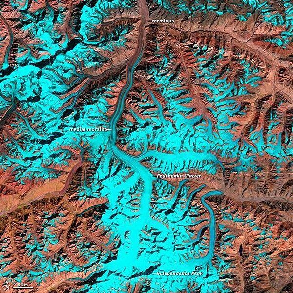
The Pamir Mountains include some of the world's tallest peaks, soaring to heights of 7,300 m (24,000 ft ). Centered in eastern Tajikistan, the Pamirs - part of the 'roof of the world' - are home to thousands of glaciers. Among them is Fedchenko, which at 77 km (47 mi) is the longest glacier outside of the Earth's polar regions. The melt waters of Fedchenko Glacier feed into the Muksu, Vakhsh, and Amu Darya Rivers before eventually making their way to the Aral Sea some 2,000 km (1,200 mi) away. In arid central Eurasia, the snow- and glacier-covered mountains serve as the region's water towers. Nearly 90% of the Central Eurasian population relies on water from the mountains for energy, agricultural, and drinking purposes.In this false-color image from 2 October 2011, the Fedchenko Glacier can be seen as it snakes its way northward from the western slopes of Independence Peak. The sparsely vegetated, arid mountains appear reddish-brown, while snow and ice are bright cyan. (Due to the angle of sunlight, this image may cause an optical illusion known as relief inversion.) Throughout the glacier's 77 km course, it drops 2,500 m (8,200 ft) in elevation. At the highest elevations, the glacier is snow and ice covered; but as it flows downstream, it picks up rockfall debris. Reddish-hued debris lines running parallel to the flow direction begin about midway down the glacier's length. These medial moraines widen as the glacier descends. At its terminus, the glacier is completely covered by debris. Image courtesy of NASA.
The Pamir Mountains include some of the world's tallest peaks, soaring to heights of 7,300 m (24,000 ft ). Centered in eastern Tajikistan, the Pamirs - part of the 'roof of the world' - are home to thousands of glaciers. Among them is Fedchenko, which at 77 km (47 mi) is the longest glacier outside of the Earth's polar regions. The melt waters of Fedchenko Glacier feed into the Muksu, Vakhsh, and Amu Darya Rivers before eventually making their way to the Aral Sea some 2,000 km (1,200 mi) away. In arid central Eurasia, the snow- and glacier-covered mountains serve as the region's water towers. Nearly 90% of the Central Eurasian population relies on water from the mountains for energy, agricultural, and drinking purposes.In this false-color image from 2 October 2011, the Fedchenko Glacier can be seen as it snakes its way northward from the western slopes of Independence Peak. The sparsely vegetated, arid mountains appear reddish-brown, while snow and ice are bright cyan. (Due to the angle of sunlight, this image may cause an optical illusion known as relief inversion.) Throughout the glacier's 77 km course, it drops 2,500 m (8,200 ft) in elevation. At the highest elevations, the glacier is snow and ice covered; but as it flows downstream, it picks up rockfall debris. Reddish-hued debris lines running parallel to the flow direction begin about midway down the glacier's length. These medial moraines widen as the glacier descends. At its terminus, the glacier is completely covered by debris. Image courtesy of NASA. • CIA World Factbook • 2020
2 photos available
Data sources: World Bank, UN Data • Updated daily •Learn about our data