›››
Timor-Leste
Timor-Leste
Population
1.4M
Rank #154Source: World Bank
Capital
Dili
Source: REST Countries
Region
Asia
East Asia & Pacific
Source: REST Countries
GDP (Nominal)
$1.87B
Rank #177Source: World Bank
Land Area
14.9K km²
Rank #156Source: REST Countries
Life Expectancy
67.689 yrs
Source: World Bank
Historical Trends
Population Trend (5-Year)
Source: World Bank
GDP Trend (5-Year, Nominal USD)
Source: World Bank
Geography
Area: 14,874 km²
Landlocked: No
Independent: Yes
Climate: tropical; hot, humid; distinct rainy and dry seasons
Terrain: mountainous
Elevation: lowest point: Timor Sea, Savu Sea, and Banda Sea 0 m highest point: Foho Tatamailau 2,963 m
Natural Hazards: floods and landslides are common; earthquakes; tsunamis; tropical cyclones
Environmental Issues: air pollution and deterioration of air quality; greenhouse gas emissions; water quality, scarcity, and access; land and soil degradation; forest depletion; widespread use of slash and burn...
Land Use: agricultural land: 25.1% (2011 est.) forest: 49.1% (2011 est.) other: 25.8% (2011 est.)
Geography Note: Timor comes from the Malay word for "east"; the island of Timor is part of the Malay Archipelago and is the largest and easternmost of the Lesser Sunda Islands; the district of Oecussi is an exclave...
Natural Resources
goldpetroleumnatural gasmanganesemarble
People & Society
Fertility Rate
2.71
Population
1.4M
Religions
Roman Catholic (97.6%)Protestant/Evangelical (2%)Muslim (0.2%)other (0.2%)
Economy
GDP per Capita
$1,331.971
GDP per Capita PPP
4,422.779
(2024)
(2024)
GNI per Capita
1,650
(2024)
(2024)
Gini Index
28.7
(2014)
(2014)
Unemployment
1.523%
(2024)
(2024)
Inflation
2.063%
(2024)
(2024)
Public Debt
Not Available
Energy
Electricity Access
100%
(2023)
(2023)
Renewable Energy
11.4%
(2022)
(2022)
CO₂ Emissions
0.699 Mt
(2024)
(2024)
Energy Intensity
2.42 MJ/$
(2022)
(2022)
Renewable Electricity
0.371%
(2021)
(2021)
Environment
Forest Coverage
61.661% of land
(2023)
(2023)
Communications
Internet Users
34.021%
(2023)
(2023)
Mobile Penetration
112.647%
(2023)
(2023)
Broadband Subscribers
0.006%
(2023)
(2023)
Transportation
Air Transport Freight
Not Available
Container Port Traffic
53,289 TEU
(2019)
(2019)
Airports
N/A
Rail Lines
N/A
Roads Total
8,811 km(©IRF)
Military
Military Forces
Timor-Leste Defense Force (Falintil-Forcas de Defesa de Timor-L'este, Falintil (F-FDTL)): Headquarters with Land and Naval components
Personnel Strength
the Timor-Leste Defense Force (F-FDLT) is comprised of approximately 2,000 troops
Military Expenditure (USD)
$0.05B
Military Expenditure (% of GDP)
2.66%
Military Expenditure History
1% of GDP (2019) 0.7% of GDP (2018) 0.9% of GDP (2017) 1% of GDP (2016) 1.2% of GDP (2015)
Equipment & Inventories
Timor-Leste Defense Force's limited inventory consists of equipment donated by other countries; the only known deliveries of major arms to Timor-Leste since 2010 are naval patrol craft from China and...
Service Age & Obligation
18 years of age for voluntary military service; 18-month service obligation
Education
Pre-Primary Enrollment
27.865%
(2020)
(2020)
Primary Enrollment
119.653%
(2023)
(2023)
Secondary Enrollment
84.741%
(2020)
(2020)
Tertiary Enrollment
30.961%
(2023)
(2023)
Education Spending
5.241% of GDP
(2023)
(2023)
Adult Literacy Rate
72.47%
(2022)
(2022)
Pupil-Teacher Ratio
26.949:1
(2018)
(2018)
Health
Physicians per 1,000
0.752
(2020)
(2020)
Safe Water Access
87.33%
(2024)
(2024)
Safe Drinking Water
Not Available
Under-5 Mortality
50 per 1,000
(2023)
(2023)
Maternal Mortality (World Bank)
18.146 per 100,000
(2021)
(2021)
Hospital Beds per 1,000
66.53
(2021)
(2021)
UHC Coverage Index
48
(2023)
(2023)
Measles Immunization
83%
(2024)
(2024)
Social Indicators
Extreme Poverty Rate
43.9%
(2014)
(2014)
Food Insecurity
18.7%
(2023)
(2023)
Youth NEET Rate
3.408%
(2022)
(2022)
Governance
Women in Government
35.385%
(2024)
(2024)
Voice & Accountability
0.43
(Above Average)
(2023)
(Above Average)
(2023)
Political Stability
0.26
(Above Average)
(2023)
(Above Average)
(2023)
Government Effectiveness
-0.84
(Below Average)
(2023)
(Below Average)
(2023)
Regulatory Quality
-0.49
(Below Average)
(2023)
(Below Average)
(2023)
Rule of Law
-0.83
(Below Average)
(2023)
(Below Average)
(2023)
Control of Corruption
-0.23
(Below Average)
(2023)
(Below Average)
(2023)
Government
Government Type
semi-presidential republic
Legal System
civil law system based on the Portuguese model; note - penal and civil law codes to replace the Indonesian codes were passed by Parliament and promulgated in 2009 and 2011, respectively
Executive Branch
chief of state: President Francisco GUTERRES (since 20 May 2017); note - the president is commander in chief of the military and is able to veto legislation, dissolve parliament, and call national...
Legislative Branch
description: unicameral National Parliament (65 seats; members directly elected in a single nationwide constituency by proportional representation vote to serve 5-year terms) elections: last held on...
Judicial Branch
highest courts: Court of Appeals (consists of the court president and NA judges) judge selection and term of office: court president appointed by the president of the republic from among the other...
International Organizations
National Symbols
Flag Description
red with a black isosceles triangle (based on the hoist side) superimposed on a slightly longer yellow arrowhead that extends to the center of the flag; a white star - pointing to the upper...
National Symbols
Mount Ramelau; national colors: red, yellow, black, white
National Anthem
name: "Patria" (Fatherland) lyrics/music: Fransisco Borja DA COSTA/Afonso DE ARAUJO note: adopted 2002; the song was first used as an anthem when Timor-Leste declared its independence from Portugal...
Safety
Homicide Rate
4.066 per 100,000
(2015)
(2015)
Travel Information
Language(s): Portuguese, Tetum
Currency: USD ($)
Timezone(s): UTC+09:00
Landlocked: No
Independent: Yes
Driving Side: Left
Calling Code: +670
Car Sign: TL
Week Starts: Monday
Photos
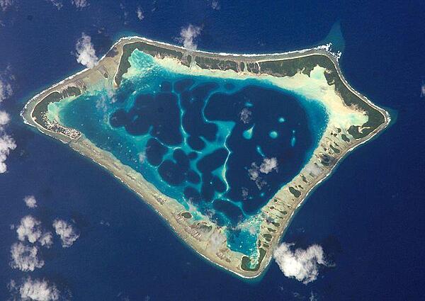
At roughly 8 km (5 mi) wide, Atafu Atoll is the smallest of three atolls comprising Tokelau. Land area is only about 2.5 sq km and the lagoon's area is about 15 sq km. The primary settlement on Atafu is a village located at the northwestern corner of the atoll - indicated by an area of light gray dots in the left part of this photograph. The typical ring shape of the atoll is the result of coral reefs building up around a former volcanic island. Over geologic time, the central volcano subsided beneath the water surface, leaving the fringing reefs and a central lagoon that contains submerged coral reefs. Image courtesy of NASA.
At roughly 8 km (5 mi) wide, Atafu Atoll is the smallest of three atolls comprising Tokelau. Land area is only about 2.5 sq km and the lagoon's area is about 15 sq km. The primary settlement on Atafu is a village located at the northwestern corner of the atoll - indicated by an area of light gray dots in the left part of this photograph. The typical ring shape of the atoll is the result of coral reefs building up around a former volcanic island. Over geologic time, the central volcano subsided beneath the water surface, leaving the fringing reefs and a central lagoon that contains submerged coral reefs. Image courtesy of NASA. • CIA World Factbook • 2020
CIA World Factbook • 2020
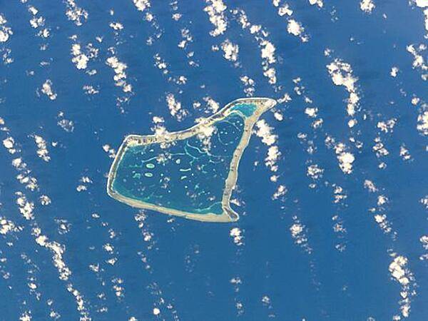
Fakaofo is one of the three islands that make up Tokelau. Its land area is only 3 sq km; the lagoon covers an area of about 45 sq km. Image courtesy of NASA.
Fakaofo is one of the three islands that make up Tokelau. Its land area is only 3 sq km; the lagoon covers an area of about 45 sq km. Image courtesy of NASA. • CIA World Factbook • 2020
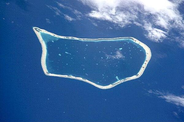
Nukunonu is the largest of the three islands that comprise Tokelau. It is composed of a roughly tear-drop shaped atoll that includes 5.5 sq km of land and whose central lagoon encompasses an area of about 90 sq km. Image courtesy of NASA.
Nukunonu is the largest of the three islands that comprise Tokelau. It is composed of a roughly tear-drop shaped atoll that includes 5.5 sq km of land and whose central lagoon encompasses an area of about 90 sq km. Image courtesy of NASA. • CIA World Factbook • 2020
4 photos available
Data sources: World Bank, UN Data • Updated daily •Learn about our data