›››
Turkmenistan
Turkmenistan
Population
7.5M
Rank #104Source: World Bank
Capital
Ashgabat
Source: REST Countries
Region
Europe
Europe & Central Asia
Source: REST Countries
GDP (Nominal)
$51.39B
Rank #92Source: World Bank
Land Area
488.1K km²
Rank #53Source: REST Countries
Life Expectancy
70.073 yrs
Source: World Bank
Historical Trends
Population Trend (5-Year)
Source: World Bank
GDP Trend (5-Year, Nominal USD)
Source: World Bank
Geography
Area: 488,100 km²
Landlocked: Yes
Independent: Yes
Climate: subtropical desert
Terrain: flat-to-rolling sandy desert with dunes rising to mountains in the south; low mountains along border with Iran; borders Caspian Sea in west
Elevation: mean elevation: 230 m lowest point: Vpadina Akchanaya (Sarygamysh Koli is a lake in northern Turkmenistan with a water level that fluctuates above and below the elevation of Vpadina Akchanaya, the...
Natural Hazards: earthquakes; mudslides; droughts; dust storms; floods
Environmental Issues: contamination of soil and groundwater with agricultural chemicals, pesticides; salination, water logging of soil due to poor irrigation methods; Caspian Sea pollution; diversion of a large share of...
Land Use: agricultural land: 72% (2011 est.) forest: 8.8% (2011 est.) other: 19.2% (2011 est.)
Geography Note: landlocked; the western and central low-lying desolate portions of the country make up the great Garagum (Kara-Kum) desert, which occupies over 80% of the country; eastern part is plateau
Natural Resources
petroleumnatural gassulfursalt
People & Society
Fertility Rate
2.69
Population
7.5M
Ethnic Groups
Turkmen (85%)Uzbek (5%)Russian (4%)other (6%)
Religions
Muslim (89%)Eastern Orthodox (9%)unknown (2%)
Economy
GDP per Capita
$6,856.658
GDP per Capita PPP
21,213.086
(2024)
(2024)
GNI per Capita
6,510
(2024)
(2024)
Gini Index
Not Available
Unemployment
4.02%
(2024)
(2024)
Inflation
Not Available
Public Debt
Not Available
Energy
Electricity Access
100%
(2023)
(2023)
Renewable Energy
0.1%
(2021)
(2021)
CO₂ Emissions
81.408 Mt
(2024)
(2024)
Energy Intensity
10.18 MJ/$
(2021)
(2021)
Renewable Electricity
0.011%
(2021)
(2021)
Environment
Forest Coverage
8.782% of land
(2023)
(2023)
Communications
Internet Users
21.251%
(2017)
(2017)
Mobile Penetration
88.193%
(2021)
(2021)
Broadband Subscribers
5.217%
(2022)
(2022)
Transportation
Air Transport Freight
62.724 M ton-km
(2023)
(2023)
Container Port Traffic
Not Available
Airports
10,676
Rail Lines
7,680 km
Roads Total
N/A
Military
Military Forces
Armed Forces of Turkmenistan: National Army, Navy, Air and Air Defense Forces; Federal Border Guard Service
Personnel Strength
the Armed Forces of Turkmenistan have approximately 37,000 active troops (est. 33,000 National Army; 500 Navy, 3,500 Air and Air Defense Forces)
Equipment & Inventories
the inventory for Turkmenistan's military is comprised almost entirely of older Russian and Soviet-era weapons systems, although in recent years, Turkmenistan has opened itself up to Chinese and...
Service Age & Obligation
18-27 years of age for compulsory male military service; 2-year conscript service obligation; 20 years of age for voluntary service; males may enroll in military schools from age 15
Education
Pre-Primary Enrollment
35.914%
(2020)
(2020)
Primary Enrollment
95.692%
(2024)
(2024)
Secondary Enrollment
94.646%
(2024)
(2024)
Tertiary Enrollment
20.425%
(2024)
(2024)
Education Spending
2.713% of GDP
(2023)
(2023)
Adult Literacy Rate
99.9%
(2022)
(2022)
Pupil-Teacher Ratio
Not Available
Health
Physicians per 1,000
1.93
(2023)
(2023)
Safe Water Access
99.922%
(2024)
(2024)
Safe Drinking Water
94.854%
(2024)
(2024)
Under-5 Mortality
40 per 1,000
(2023)
(2023)
Maternal Mortality (World Bank)
19.674 per 100,000
(2021)
(2021)
Hospital Beds per 1,000
65.707
(2021)
(2021)
UHC Coverage Index
81
(2023)
(2023)
Measles Immunization
98%
(2024)
(2024)
Social Indicators
Extreme Poverty Rate
Not Available
Food Insecurity
4.3%
(2023)
(2023)
Youth NEET Rate
Not Available
Governance
Women in Government
25.6%
(2024)
(2024)
Voice & Accountability
-1.88
(Weak)
(2023)
(Weak)
(2023)
Political Stability
-0.11
(Below Average)
(2023)
(Below Average)
(2023)
Government Effectiveness
-1.21
(Weak)
(2023)
(Weak)
(2023)
Regulatory Quality
-2.07
(Weak)
(2023)
(Weak)
(2023)
Rule of Law
-1.49
(Weak)
(2023)
(Weak)
(2023)
Control of Corruption
-1.42
(Weak)
(2023)
(Weak)
(2023)
Government
Government Type
presidential republic; authoritarian
Legal System
civil law system with Islamic (sharia) law influences
Executive Branch
chief of state: President Gurbanguly BERDIMUHAMEDOW (since 14 February 2007); note - the president is both chief of state and head of government head of government: President Gurbanguly...
Legislative Branch
description: unicameral National Assembly or Mejlis (125 seats; members directly elected from single-seat constituencies by absolute majority vote; members serve 5-year terms) elections: last held on...
Judicial Branch
highest courts: Supreme Court of Turkmenistan (consists of the court president and 21 associate judges and organized into civil, criminal, and military chambers) judge selection and term of...
National Symbols
Flag Description
green field with a vertical red stripe near the hoist side, containing five tribal guls (designs used in producing carpets) stacked above two crossed olive branches; five white, five-pointed stars...
National Symbols
Akhal-Teke horse; national colors: green, white
National Anthem
name: "Garassyz, Bitarap Turkmenistanyn" (Independent, Neutral, Turkmenistan State Anthem) lyrics/music: collective/Veli MUKHATOV note: adopted 1997, lyrics revised in 2008, to eliminate references...
Safety
Homicide Rate
1.014 per 100,000
(2015)
(2015)
Travel Information
Language(s): Russian, Turkmen
Currency: TMT (m)
Timezone(s): UTC+05:00
Landlocked: Yes
Independent: Yes
Driving Side: Right
Calling Code: +993
Car Sign: TM
Week Starts: Monday
Photos
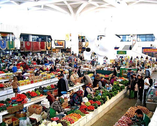
Colorful market in Ashgabat.
Colorful market in Ashgabat. • CIA World Factbook • 2020
Area comparison map
Area comparison map • CIA World Factbook • 2020
CIA World Factbook • 2020
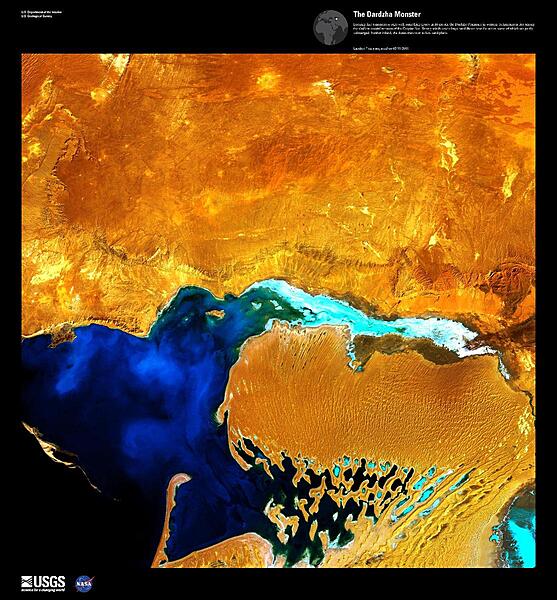
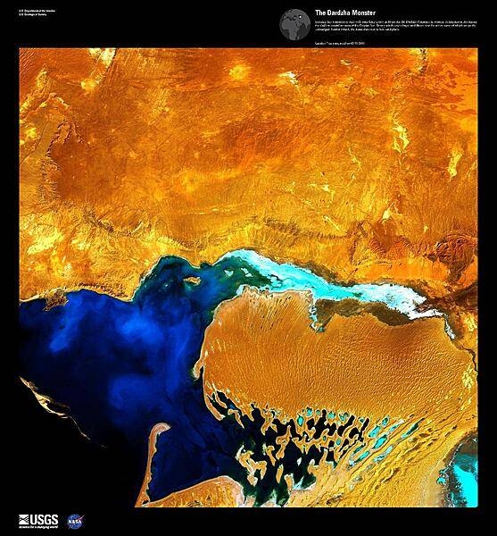
Looking like a monstrous ogre with something gooey in its mouth, this enhanced satellite image shows the Dardzha Peninsula in western Turkmenistan, which lies among the shallow coastal terraces of the Caspian Sea. Strong winds create huge sand dunes near the water, some of which are partly submerged. Further inland, the dunes transition to low sand plains. Image courtesy of USGS.
Looking like a monstrous ogre with something gooey in its mouth, this enhanced satellite image shows the Dardzha Peninsula in western Turkmenistan, which lies among the shallow coastal terraces of the Caspian Sea. Strong winds create huge sand dunes near the water, some of which are partly submerged. Further inland, the dunes transition to low sand plains. Image courtesy of USGS. • CIA World Factbook • 2020
4 photos available
Data sources: World Bank, UN Data • Updated daily •Learn about our data