›››
Tonga
Tonga
Population
104.2K
Rank #193Source: World Bank
Capital
Nuku'alofa
Source: REST Countries
Region
Oceania
East Asia & Pacific
Source: REST Countries
GDP (Nominal)
$591.14M
Source: World Bank
Land Area
747 km²
Rank #183Source: REST Countries
Life Expectancy
72.895 yrs
Source: World Bank
Historical Trends
Population Trend (5-Year)
Source: World Bank
GDP Trend (5-Year, Nominal USD)
Source: World Bank
Geography
Area: 747 km²
Landlocked: No
Independent: Yes
Climate: tropical; modified by trade winds; warm season (December to May), cool season (May to December)
Terrain: mostly flat islands with limestone bedrock formed from uplifted coral formation; others have limestone overlying volcanic rock
Elevation: lowest point: Pacific Ocean 0 m highest point: Kao Volcano on Kao Island 1,046 m
Natural Hazards: cyclones (October to April); earthquakes and volcanic activity on Fonuafo'ouvolcanism: moderate volcanic activity; Fonualei (180 m) has shown frequent activity in recent years, while Niuafo'ou (260...
Environmental Issues: deforestation from land being cleared for agriculture and settlement; soil exhaustion; water pollution due to salinization, sewage, and toxic chemicals from farming activities; coral reefs and marine...
Land Use: agricultural land: 43.1% (2011 est.) forest: 12.5% (2011 est.) other: 44.4% (2011 est.)
Geography Note: the western islands (making up the Tongan Volcanic Arch) are all of volcanic origin; the eastern islands are nonvolcanic and are composed of coral limestone and sand
Natural Resources
arable landfish
People & Society
Fertility Rate
3.13
Population
104.2K
Ethnic Groups
Tongan (97%)part-Tongan (0.8%)other (2.2%)
Religions
Protestant 64.1% (includes Free Wesleyan Church (35%)Free Church of Tonga (11.9%)Church of Tonga (6.8%)Assembly of God (2.3%)Seventh Day Adventist (2.2%)Tokaikolo Christian Church (1.6%)other (4.3%)Mormon (18.6%)Roman Catholic (14.2%)other (2.4%)none (0.5%)unspecified (0.1%)
Economy
GDP per Capita
$5,651.594
GDP per Capita PPP
7,802.67
(2023)
(2023)
GNI per Capita
5,910
(2023)
(2023)
Gini Index
27.1
(2021)
(2021)
Unemployment
1.965%
(2024)
(2024)
Inflation
3.184%
(2024)
(2024)
Public Debt
43.081%
(2020)
(2020)
Energy
Electricity Access
100%
(2023)
(2023)
Renewable Energy
2.3%
(2022)
(2022)
CO₂ Emissions
0.17 Mt
(2024)
(2024)
Energy Intensity
4.03 MJ/$
(2022)
(2022)
Renewable Electricity
14.201%
(2021)
(2021)
Environment
Forest Coverage
12.431% of land
(2023)
(2023)
Protected Areas
2.53% of land
(2009)
(2009)
Communications
Internet Users
58.533%
(2023)
(2023)
Mobile Penetration
61.726%
(2022)
(2022)
Broadband Subscribers
8.174%
(2022)
(2022)
Transportation
Air Transport Freight
Not Available
Container Port Traffic
76,853.95 TEU
(2019)
(2019)
Airports
N/A
Rail Lines
N/A
Roads Total
N/A
Military
Military Forces
Tonga Defense Services: Joint Force headquarters, Territorial Forces, Land Force, Tonga Navy, Training Wing, Air Wing, and Support Unit
Personnel Strength
the Tonga Defense Services have approximately 500 personnel
Equipment & Inventories
the Tonga military's inventory includes mostly light weapons and equipment from European (primarily the UK) countries and the US, as well as naval patrol vessels from Australia; Australia is the only...
Service Age & Obligation
Volunteers, 18-25; no conscription
Education
Pre-Primary Enrollment
48.32%
(2020)
(2020)
Primary Enrollment
108.79%
(2024)
(2024)
Secondary Enrollment
92.426%
(2024)
(2024)
Tertiary Enrollment
42.861%
(2023)
(2023)
Education Spending
5.31% of GDP
(2022)
(2022)
Adult Literacy Rate
91.05%
(2019)
(2019)
Pupil-Teacher Ratio
21.633:1
(2015)
(2015)
Health
Physicians per 1,000
1.014
(2021)
(2021)
Safe Water Access
98.858%
(2024)
(2024)
Safe Drinking Water
29.598%
(2024)
(2024)
Under-5 Mortality
9.9 per 1,000
(2023)
(2023)
Maternal Mortality (World Bank)
17.386 per 100,000
(2021)
(2021)
Hospital Beds per 1,000
75.29
(2021)
(2021)
UHC Coverage Index
71
(2023)
(2023)
Measles Immunization
99%
(2024)
(2024)
Social Indicators
Extreme Poverty Rate
0.4%
(2021)
(2021)
Food Insecurity
Not Available
Youth NEET Rate
4.757%
(2023)
(2023)
Governance
Women in Government
7.143%
(2024)
(2024)
Voice & Accountability
0.87
(Above Average)
(2023)
(Above Average)
(2023)
Political Stability
1.09
(Strong)
(2023)
(Strong)
(2023)
Government Effectiveness
-0.12
(Below Average)
(2023)
(Below Average)
(2023)
Regulatory Quality
-0.39
(Below Average)
(2023)
(Below Average)
(2023)
Rule of Law
0.55
(Above Average)
(2023)
(Above Average)
(2023)
Control of Corruption
-0.31
(Below Average)
(2023)
(Below Average)
(2023)
Government
Government Type
constitutional monarchy
Legal System
English common law
Executive Branch
chief of state: King TUPOU VI (since 18 March 2012); Heir Apparent Crown Prince Siaosi Manumataogo 'Alaivahamama'o 'Ahoeitu Konstantin Tuku'aho, son of the king (born 17 September 1985); note - on 18...
Legislative Branch
description: unicameral Legislative Assembly or Fale Alea (up to 30 seats; - 26 for the 2017-19 term); 17 people's representatives directly elected in single-seat constituencies by simple majority...
Judicial Branch
highest courts: Court of Appeal (consists of the court president and a number of judges determined by the monarch); note - appeals beyond the Court of Appeal are brought before the King in Privy...
National Symbols
Flag Description
red with a bold red cross on a white rectangle in the upper hoist-side corner; the cross reflects the deep-rooted Christianity in Tonga, red represents the blood of Christ and his sacrifice, and...
National Symbols
red cross on white field, arms equal length; national colors: red, white
National Anthem
name: "Ko e fasi `o e tu"i `o e `Otu Tonga" (Song of the King of the Tonga Islands) lyrics/music: Uelingatoni Ngu TUPOUMALOHI/Karl Gustavus SCHMITT note: in use since 1875; more commonly known as...
Safety
Homicide Rate
0.946 per 100,000
(2019)
(2019)
Travel Information
Language(s): English, Tongan
Currency: TOP (T$)
Timezone(s): UTC+13:00
Landlocked: No
Independent: Yes
Driving Side: Left
Calling Code: +676
Car Sign: TO
Week Starts: Monday
Photos
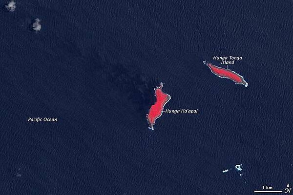
In this earlier satellite view of the islands of Hunga Tonga and Hunga Ha'apai from 14 November 2006, the healthy vegetation appears bright red and Hunga Ha'apai is significantly smaller in size than in the previous image. Photo courtesy of NASA.
In this earlier satellite view of the islands of Hunga Tonga and Hunga Ha'apai from 14 November 2006, the healthy vegetation appears bright red and Hunga Ha'apai is significantly smaller in size than in the previous image. Photo courtesy of NASA. • CIA World Factbook • 2020
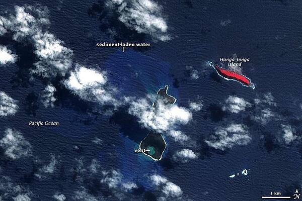
In mid-March 2009, a plume of ash and gas burst out of the ocean as an undersea volcano began to erupt in the South Pacific nation of Tonga. Small sections of the rim of the large volcano had been above water, forming the islands of Hunga Tonga and Hunga Ha'apai (center). The eruption occurred at two vents, one submerged and the other on Hunga Ha'apai. The eruption pumped out enough rock and ash that by 25 March, when NASA's Terra satellite captured this image, the submerged vent was surrounded by new land. The new land is the dark mass south of Hunga Ha'apai. It was not present in an earlier image taken on 14 November 2006 (next photo). In this image, clouds cover the space between the new land and Hunga Ha'apai, but the new land connects Hunga Ha'apai with the underwater vent, essentially enlarging the small island. The vent itself is the nearly perfectly circular hole near the southern edge of the new land. Also revealed are some of the other impacts of the eruption. The ocean around the erupting volcano is bright blue, likely colored with ash, rock, and other volcanic debris. The eruption killed or damaged plants on Hunga Ha'apai. In this false-color image, plant cover is red. In 2006, Hunga Ha'apai had supported vegetation, but after the eruption, the island was black. Either the plants were buried in ash or dead in the wake of the eruption. Photo courtesy of NASA.
In mid-March 2009, a plume of ash and gas burst out of the ocean as an undersea volcano began to erupt in the South Pacific nation of Tonga. Small sections of the rim of the large volcano had been above water, forming the islands of Hunga Tonga and Hunga Ha'apai (center). The eruption occurred at two vents, one submerged and the other on Hunga Ha'apai. The eruption pumped out enough rock and ash that by 25 March, when NASA's Terra satellite captured this image, the submerged vent was surrounded by new land.
The new land is the dark mass south of Hunga Ha'apai. It was not present in an earlier image taken on 14 November 2006 (next photo). In this image, clouds cover the space between the new land and Hunga Ha'apai, but the new land connects Hunga Ha'apai with the underwater vent, essentially enlarging the small island. The vent itself is the nearly perfectly circular hole near the southern edge of the new land.
Also revealed are some of the other impacts of the eruption. The ocean around the erupting volcano is bright blue, likely colored with ash, rock, and other volcanic debris. The eruption killed or damaged plants on Hunga Ha'apai. In this false-color image, plant cover is red. In 2006, Hunga Ha'apai had supported vegetation, but after the eruption, the island was black. Either the plants were buried in ash or dead in the wake of the eruption. Photo courtesy of NASA. • CIA World Factbook • 2020
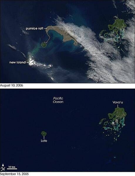
August 2006 brought two new things to the Tonga Islands in the South Pacific. One was a raft of lightweight, frothy volcanic rock - pumice - floating on the ocean surface. The other was a new island emerging out of the water. NASA's Aqua satellite captured the aftermath of the eruption on 10 August 2006. For comparison, the bottom image shows the same area but taken almost one year earlier, on 15 September 2005. The emerging volcanic island is partially hidden by its own plume. Volcanic plumes often appear drab gray or beige compared to clouds, and plumes from the emerging island move away from it in different directions, one to the southeast, and some to the north. The bright white spot directly over the island may be cloud cover, or it could be steam resulting from volcanic emissions. The raft of pumice appears to the northeast of the emerging island, and it actually connects, via a thin thread, to neighboring Late Island. The blue-green color of the water around the raft and the new island is probably fine sediment that is making the deep blue water more reflective. The pumice raft gained international attention when a news report described the experience of a yacht crew that inadvertently encountered the pumice raft. The "sea of stone" clogged the yacht's engine-cooling system, forcing the vessel to turn back. Pumice rafts are not an everyday occurrence, but they have been observed before. Biologists theorize that pumice rafts may be one of the ways that plants and animals spread from island to island in marine environments. Photo courtesy of NASA.
August 2006 brought two new things to the Tonga Islands in the South Pacific. One was a raft of lightweight, frothy volcanic rock - pumice - floating on the ocean surface. The other was a new island emerging out of the water. NASA's Aqua satellite captured the aftermath of the eruption on 10 August 2006. For comparison, the bottom image shows the same area but taken almost one year earlier, on 15 September 2005.
The emerging volcanic island is partially hidden by its own plume. Volcanic plumes often appear drab gray or beige compared to clouds, and plumes from the emerging island move away from it in different directions, one to the southeast, and some to the north. The bright white spot directly over the island may be cloud cover, or it could be steam resulting from volcanic emissions.
The raft of pumice appears to the northeast of the emerging island, and it actually connects, via a thin thread, to neighboring Late Island. The blue-green color of the water around the raft and the new island is probably fine sediment that is making the deep blue water more reflective. The pumice raft gained international attention when a news report described the experience of a yacht crew that inadvertently encountered the pumice raft. The "sea of stone" clogged the yacht's engine-cooling system, forcing the vessel to turn back.
Pumice rafts are not an everyday occurrence, but they have been observed before. Biologists theorize that pumice rafts may be one of the ways that plants and animals spread from island to island in marine environments. Photo courtesy of NASA. • CIA World Factbook • 2020
3 photos available
Data sources: World Bank, UN Data • Updated daily •Learn about our data