›››
Trinidad and Tobago
Trinidad and Tobago
Population
1.4M
Rank #156Source: World Bank
Capital
Port-of-Spain
Source: REST Countries
Region
Americas
Latin America & Caribbean
Source: REST Countries
GDP (Nominal)
$25.63B
Rank #115Source: World Bank
Land Area
5.1K km²
Rank #169Source: REST Countries
Life Expectancy
73.49 yrs
Source: World Bank
Historical Trends
Population Trend (5-Year)
Source: World Bank
GDP Trend (5-Year, Nominal USD)
Source: World Bank
Geography
Area: 5,130 km²
Landlocked: No
Independent: Yes
Climate: tropical; rainy season (June to December)
Terrain: mostly plains with some hills and low mountains
Elevation: mean elevation: 83 m lowest point: Caribbean Sea 0 m highest point: El Cerro del Aripo 940 m
Natural Hazards: outside usual path of hurricanes and other tropical storms
Environmental Issues: water pollution from agricultural chemicals, industrial wastes, and raw sewage; widespread pollution of waterways and coastal areas; illegal dumping; deforestation; soil erosion; fisheries and...
Land Use: agricultural land: 10.6% (2011 est.) forest: 44% (2011 est.) other: 45.4% (2011 est.)
Geography Note: Pitch Lake, on Trinidad's southwestern coast, is the world's largest natural reservoir of asphalt
Natural Resources
petroleumnatural gasasphalt
People & Society
Fertility Rate
1.53
Population
1.4M
Ethnic Groups
East Indian (35.4%)African descent (34.2%)mixed - other (15.3%)mixed - African/East Indian (7.7%)other (1.3%)unspecified (6.2%)
Religions
Protestant 32.1% (Pentecostal/Evangelical/Full Gospel (12%)Baptist (6.9%)Anglican (5.7%)Seventh-Day Adventist (4.1%)Presbyterian/Congregational (2.5%)other Protestant (0.9%)Roman Catholic (21.6%)Hindu (18.2%)Muslim (5%)Jehovah's Witness (1.5%)other (8.4%)none (2.2%)unspecified (11.1%)
Economy
GDP per Capita
$18,733.411
GDP per Capita PPP
36,328.513
(2024)
(2024)
GNI per Capita
19,740
(2024)
(2024)
Gini Index
Not Available
Unemployment
3.318%
(2024)
(2024)
Inflation
0.527%
(2024)
(2024)
Public Debt
Not Available
Energy
Electricity Access
98.7%
(2023)
(2023)
Renewable Energy
0.5%
(2021)
(2021)
CO₂ Emissions
26.793 Mt
(2024)
(2024)
Energy Intensity
18.72 MJ/$
(2021)
(2021)
Renewable Electricity
0.068%
(2021)
(2021)
Environment
Forest Coverage
44.236% of land
(2023)
(2023)
Communications
Internet Users
84.699%
(2023)
(2023)
Mobile Penetration
134.231%
(2023)
(2023)
Broadband Subscribers
26.894%
(2023)
(2023)
Transportation
Air Transport Freight
45.836 M ton-km
(2023)
(2023)
Container Port Traffic
498,544 TEU
(2022)
(2022)
Airports
27,936
Rail Lines
N/A
Roads Total
9,592 km(©IRF)
Military
Military Forces
Trinidad and Tobago Defense Force (TTDF): Trinidad and Tobago Regiment (Land Forces), Coast Guard, Air Guard, Defense Force Reserves
Personnel Strength
the Trinidad and Tobago Defense Force (TTDF) has approximately 4,000 active troops, including Army, Coast Guard, and Air Guard personnel
Military Expenditure (USD)
$0.23B
Military Expenditure (% of GDP)
0.92%
Military Expenditure History
0.7% of GDP (2019) 0.8% of GDP (2018) 1% of GDP (2017) 1% of GDP (2016) 0.9% of GDP (2015)
Equipment & Inventories
the TTDF's ground force inventory includes only light weapons; the Coast Guard and Air Guard field mostly second-hand equipment from a mix of countries, including Australia, China, the Netherlands,...
Service Age & Obligation
18-25 years of age for voluntary military service (some age variations between services, reserves); no conscription
Education
Pre-Primary Enrollment
64.489%
(2021)
(2021)
Primary Enrollment
99.189%
(2023)
(2023)
Secondary Enrollment
92.938%
(2023)
(2023)
Tertiary Enrollment
Not Available
Education Spending
3.011% of GDP
(2023)
(2023)
Pupil-Teacher Ratio
Not Available
Health
Physicians per 1,000
4.157
(2021)
(2021)
Safe Water Access
99.25%
(2024)
(2024)
Safe Drinking Water
69.369%
(2024)
(2024)
Under-5 Mortality
19.1 per 1,000
(2023)
(2023)
Maternal Mortality (World Bank)
21.053 per 100,000
(2021)
(2021)
Hospital Beds per 1,000
68.411
(2021)
(2021)
UHC Coverage Index
75
(2023)
(2023)
Measles Immunization
92%
(2024)
(2024)
Social Indicators
Extreme Poverty Rate
Not Available
Food Insecurity
11.2%
(2023)
(2023)
Youth NEET Rate
10.914%
(2024)
(2024)
Governance
Women in Government
28.571%
(2024)
(2024)
Voice & Accountability
0.62
(Above Average)
(2023)
(Above Average)
(2023)
Political Stability
0.40
(Above Average)
(2023)
(Above Average)
(2023)
Government Effectiveness
-0.04
(Below Average)
(2023)
(Below Average)
(2023)
Regulatory Quality
-0.13
(Below Average)
(2023)
(Below Average)
(2023)
Rule of Law
-0.28
(Below Average)
(2023)
(Below Average)
(2023)
Control of Corruption
-0.37
(Below Average)
(2023)
(Below Average)
(2023)
Government
Government Type
parliamentary republic
Legal System
English common law; judicial review of legislative acts in the Supreme Court
Executive Branch
chief of state: President Paula-Mae WEEKES (since 19 March 2018) head of government: Prime Minister Keith ROWLEY (since 9 September 2015) cabinet: Cabinet appointed from among members of...
Legislative Branch
description: bicameral Parliament consists of:Senate (31 seats; 16 members appointed by the ruling party, 9 by the president, and 6 by the opposition party; members serve 5-year terms;)House of...
Judicial Branch
highest courts: Supreme Court of the Judicature (consists of a chief justice for both the Court of Appeal with 12 judges and the High Court with 24 judges); note - Trinidad and Tobago can file...
National Symbols
Flag Description
red with a white-edged black diagonal band from the upper hoist side to the lower fly side; the colors represent the elements of earth, water, and fire; black stands for the wealth of the land and...
National Symbols
scarlet ibis (bird of Trinidad), cocrico (bird of Tobago), Chaconia flower; national colors: red, white, black
National Anthem
name: Forged From the Love of Liberty lyrics/music: Patrick Stanislaus CASTAGNE note: adopted 1962; song originally created to serve as an anthem for the West Indies Federation; adopted by Trinidad...
Safety
Homicide Rate
40.443 per 100,000
(2022)
(2022)
Travel Information
Language(s): English
Currency: TTD ($)
Timezone(s): UTC-04:00
Landlocked: No
Independent: Yes
Driving Side: Left
Calling Code: +1
Car Sign: TT
Week Starts: Monday
Photos
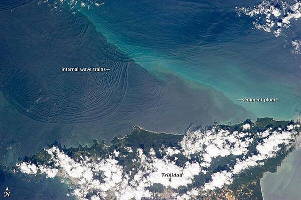
This space station photo of 18 January 2013, shows the north coast of Trinidad and a series of subtle, interacting arcs in the southeastern Caribbean Sea. These are known as "internal waves," the surface manifestation of slow waves that move tens of meters beneath the sea surface. Internal waves produce enough of an effect on the sea surface to be seen from space, but only where they are enhanced due to reflection of sunlight, or sunglint, back towards the space station. The image shows at least three sets of internal waves interacting. The most prominent set (image top left) shows a packet of several waves moving from the northwest due to the tidal flow towards the north coast of Trinidad. Two less prominent, younger sets can be seen further out to sea. A very broad set enters the view from the north and northeast, and interacts at image top center with the first set. All the internal waves are probably caused by the shelf break near Tobago (outside the image to top right). The shelf break is the step between shallow seas (around continents and islands) and the deep ocean. It is the line at which tides usually start to generate internal waves. Over the island of Trinidad, the heating of the land surface sets off the growth of cumulus clouds. Off the coast, a light blue northwest-southeast trending plume at image center is sediment embedded in the Equatorial Current (also known as the Guyana Current). The current is transporting material to the northwest - in almost the opposite direction of the internal waves. The current flows strongly from east to west around Trinidad, all the way from equatorial Africa, driven by year-round easterly winds. Seafarers in the vicinity of Trinidad are warned that the current - and its local reverse eddies - make navigation complicated and sometimes dangerous for smaller craft in these waters. Astronauts also have observed internal waves in other parts of the world, such as San Francisco and the Straits of Gibraltar. Photo courtesy of NASA.
This space station photo of 18 January 2013, shows the north coast of Trinidad and a series of subtle, interacting arcs in the southeastern Caribbean Sea. These are known as "internal waves," the surface manifestation of slow waves that move tens of meters beneath the sea surface. Internal waves produce enough of an effect on the sea surface to be seen from space, but only where they are enhanced due to reflection of sunlight, or sunglint, back towards the space station.
The image shows at least three sets of internal waves interacting. The most prominent set (image top left) shows a packet of several waves moving from the northwest due to the tidal flow towards the north coast of Trinidad. Two less prominent, younger sets can be seen further out to sea. A very broad set enters the view from the north and northeast, and interacts at image top center with the first set. All the internal waves are probably caused by the shelf break near Tobago (outside the image to top right). The shelf break is the step between shallow seas (around continents and islands) and the deep ocean. It is the line at which tides usually start to generate internal waves.
Over the island of Trinidad, the heating of the land surface sets off the growth of cumulus clouds. Off the coast, a light blue northwest-southeast trending plume at image center is sediment embedded in the Equatorial Current (also known as the Guyana Current). The current is transporting material to the northwest - in almost the opposite direction of the internal waves. The current flows strongly from east to west around Trinidad, all the way from equatorial Africa, driven by year-round easterly winds. Seafarers in the vicinity of Trinidad are warned that the current - and its local reverse eddies - make navigation complicated and sometimes dangerous for smaller craft in these waters.
Astronauts also have observed internal waves in other parts of the world, such as San Francisco and the Straits of Gibraltar. Photo courtesy of NASA. • CIA World Factbook • 2020
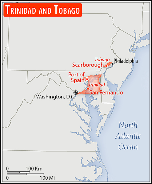
Area comparison map
Area comparison map • CIA World Factbook • 2020
2 photos available
Data sources: World Bank, UN Data • Updated daily •Learn about our data