›››
Uzbekistan
Uzbekistan
Population
36.4M
Rank #43Source: World Bank
Capital
Tashkent
Source: REST Countries
Region
Europe
Europe & Central Asia
Source: REST Countries
GDP (Nominal)
$114.97B
Rank #67Source: World Bank
Land Area
447.4K km²
Rank #57Source: REST Countries
Life Expectancy
72.388 yrs
Source: World Bank
Historical Trends
Population Trend (5-Year)
Source: World Bank
GDP Trend (5-Year, Nominal USD)
Source: World Bank
Geography
Area: 447,400 km²
Landlocked: Yes
Independent: Yes
Climate: mostly mid-latitude desert, long, hot summers, mild winters; semiarid grassland in east
Terrain: mostly flat-to-rolling sandy desert with dunes; broad, flat intensely irrigated river valleys along course of Amu Darya, Syr Darya (Sirdaryo), and Zarafshon; Fergana Valley in east surrounded by...
Elevation: lowest point: Sariqamish Kuli -12 m highest point: Adelunga Toghi 4,301 m
Natural Hazards: earthquakes; floods; landslides or mudslides; avalanches; droughts
Environmental Issues: shrinkage of the Aral Sea has resulted in growing concentrations of chemical pesticides and natural salts; these substances are then blown from the increasingly exposed lake bed and contribute to...
Land Use: agricultural land: 62.6% (2011 est.) forest: 7.7% (2011 est.) other: 29.7% (2011 est.)
Geography Note: along with Liechtenstein, one of the only two doubly landlocked countries in the world
Natural Resources
natural gaspetroleumcoalgolduraniumsilvercopperlead and zinctungstenmolybdenum
People & Society
Fertility Rate
3.50
Population
36.4M
Ethnic Groups
Uzbek (83.8%)Tajik (4.8%)Kazakh (2.5%)Russian (2.3%)Karakalpak (2.2%)Tatar (1.5%)other (4.4%)
Religions
Muslim (88%)Eastern Orthodox (9%)other (3%)
Economy
GDP per Capita
$3,161.7
GDP per Capita PPP
11,878.553
(2024)
(2024)
GNI per Capita
3,020
(2024)
(2024)
Gini Index
34.6
(2024)
(2024)
Unemployment
4.439%
(2024)
(2024)
Inflation
9.628%
(2024)
(2024)
Public Debt
Not Available
Energy
Electricity Access
100%
(2023)
(2023)
Renewable Energy
1%
(2021)
(2021)
CO₂ Emissions
148.539 Mt
(2024)
(2024)
Energy Intensity
7.55 MJ/$
(2021)
(2021)
Renewable Electricity
7.077%
(2021)
(2021)
Environment
Forest Coverage
8.549% of land
(2023)
(2023)
Communications
Internet Users
89.014%
(2023)
(2023)
Mobile Penetration
106.885%
(2023)
(2023)
Broadband Subscribers
30.27%
(2023)
(2023)
Transportation
Air Transport Freight
96.459 M ton-km
(2023)
(2023)
Container Port Traffic
Not Available
Airports
29,916
Rail Lines
4,732 km
Roads Total
N/A
Military
Military Forces
Armed Forces of Uzbekistan: Army, Air and Air Defense Forces; National Guard; Ministry of Internal Affairs: Internal Security Troops
Personnel Strength
assessments for the size of the Armed Forces of Uzbekistan vary; approximately 55,000 total active troops (est. 45,000 Army; est. 10,000 Air and Air Defense Forces)
Military Expenditure (USD)
$1.44B
Military Expenditure (% of GDP)
2.87%
Military Expenditure History
4% of GDP (2018) 3.5% of GDP (2010)
Equipment & Inventories
the Uzbek Armed Forces use mainly Soviet-era equipment, although since 2010 they have received weapons and aircraft from a variety of sources, including China, France, Russia, Spain, Turkey, and the...
Service Age & Obligation
18-27 years of age for compulsory military service; 1-year conscript service obligation for males (conscripts have the option of paying for a shorter service of one month while remaining in the...
Education
Pre-Primary Enrollment
44.012%
(2021)
(2021)
Primary Enrollment
94.432%
(2024)
(2024)
Secondary Enrollment
96.84%
(2024)
(2024)
Tertiary Enrollment
56.517%
(2024)
(2024)
Education Spending
5.473% of GDP
(2023)
(2023)
Adult Literacy Rate
100%
(2022)
(2022)
Pupil-Teacher Ratio
21.507:1
(2018)
(2018)
Health
Physicians per 1,000
2.805
(2021)
(2021)
Safe Water Access
97.29%
(2024)
(2024)
Safe Drinking Water
81.93%
(2024)
(2024)
Under-5 Mortality
13.3 per 1,000
(2023)
(2023)
Maternal Mortality (World Bank)
16.258 per 100,000
(2021)
(2021)
Hospital Beds per 1,000
72.189
(2021)
(2021)
UHC Coverage Index
79
(2023)
(2023)
Measles Immunization
90%
(2024)
(2024)
Social Indicators
Extreme Poverty Rate
2.7%
(2024)
(2024)
Food Insecurity
2.5%
(2023)
(2023)
Youth NEET Rate
13.184%
(2020)
(2020)
Governance
Women in Government
38%
(2024)
(2024)
Voice & Accountability
-1.31
(Weak)
(2023)
(Weak)
(2023)
Political Stability
-0.15
(Below Average)
(2023)
(Below Average)
(2023)
Government Effectiveness
-0.28
(Below Average)
(2023)
(Below Average)
(2023)
Regulatory Quality
-0.58
(Below Average)
(2023)
(Below Average)
(2023)
Rule of Law
-0.83
(Below Average)
(2023)
(Below Average)
(2023)
Control of Corruption
-0.81
(Below Average)
(2023)
(Below Average)
(2023)
Government
Government Type
presidential republic; highly authoritarian
Legal System
civil law system; note - in early 2020, the president signed an amendment to the criminal code, criminal procedure code, and code of administrative responsibility
Executive Branch
chief of state: President Shavkat MIRZIYOYEV (interim president from 8 September 2016; formally elected president on 4 December 2016 to succeed longtime President Islom KARIMOV, who died on 2...
Legislative Branch
description: bicameral Supreme Assembly or Oliy Majlis consists of:Senate (100 seats; 84 members indirectly elected by regional governing councils and 16 appointed by the president; members serve...
Judicial Branch
highest courts: Supreme Court (consists of 67 judges organized into administrative, civil, criminal, and economic sections); Constitutional Court (consists of 7 judges) judge selection and term of...
National Symbols
Flag Description
three equal horizontal bands of blue (top), white, and green separated by red fimbriations with a vertical, white crescent moon (closed side to the hoist) and 12 white, five-pointed stars shifted to...
National Symbols
khumo (mythical bird); national colors: blue, white, red, green
National Anthem
name: "O'zbekiston Respublikasining Davlat Madhiyasi" (National Anthem of the Republic of Uzbekistan) lyrics/music: Abdulla ARIPOV/Mutal BURHANOV note: adopted 1992; after the fall of the Soviet...
Safety
Homicide Rate
1.399 per 100,000
(2021)
(2021)
Travel Information
Language(s): Russian, Uzbek
Currency: UZS (so'm)
Timezone(s): UTC+05:00
Landlocked: Yes
Independent: Yes
Driving Side: Right
Calling Code: +998
Car Sign: UZ
Week Starts: Monday
Photos
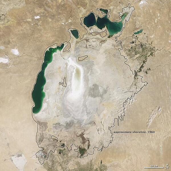
Throughout the first half of the 20th century, the Aral Sea was the world's fourth-largest lake. In the 1960s, the Soviet Union began a massive irrigation project in what are now Kazakhstan, Uzbekistan, and Turkmenistan, diverting water from the rivers that feed the Aral Sea to irrigate farmland. As its water levels dropped, the lake began splitting into smaller pieces: the Northern (Small) Aral Sea and the Southern (Large) Aral Sea. The Southern Aral Sea further split into eastern and western lobes. In August 2009 when this photo was taken, the Northern Aral Sea (upper right) still appeared healthy, the Southern Aral Sea consisted of two isolated water bodies: an irregular oval shape directly southwest of the Northern Aral Sea, and the long, thin remainder of the Southern Aral Sea's far western lobe. Much of what finally doomed the Southern Aral Sea was an attempt to save its neighbor to the north. In 2005, Kazakhstan built the Kok-Aral Dam between the lake's northern and southern portions to preserve water levels in the north. The Northern Aral Sea actually exceeded expectations with the speed of its recovery, but the dam ended prospects for a recovery of the Southern Aral Sea, which some authorities already regarded as beyond help. Lake sediments from this depleted water body have provided ample material for frequent dust storms. Image courtesy of NASA.
Throughout the first half of the 20th century, the Aral Sea was the world's fourth-largest lake. In the 1960s, the Soviet Union began a massive irrigation project in what are now Kazakhstan, Uzbekistan, and Turkmenistan, diverting water from the rivers that feed the Aral Sea to irrigate farmland. As its water levels dropped, the lake began splitting into smaller pieces: the Northern (Small) Aral Sea and the Southern (Large) Aral Sea. The Southern Aral Sea further split into eastern and western lobes. In August 2009 when this photo was taken, the Northern Aral Sea (upper right) still appeared healthy, the Southern Aral Sea consisted of two isolated water bodies: an irregular oval shape directly southwest of the Northern Aral Sea, and the long, thin remainder of the Southern Aral Sea's far western lobe. Much of what finally doomed the Southern Aral Sea was an attempt to save its neighbor to the north. In 2005, Kazakhstan built the Kok-Aral Dam between the lake's northern and southern portions to preserve water levels in the north. The Northern Aral Sea actually exceeded expectations with the speed of its recovery, but the dam ended prospects for a recovery of the Southern Aral Sea, which some authorities already regarded as beyond help. Lake sediments from this depleted water body have provided ample material for frequent dust storms. Image courtesy of NASA. • CIA World Factbook • 2020
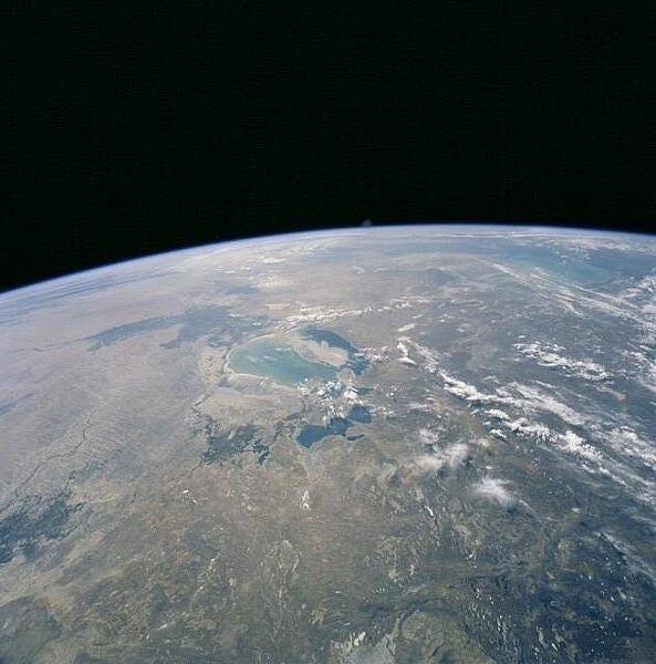
The Aral Sea, on the border between Kazakhstan and Uzbekistan, has diminished dramatically since the 1950s when its water was diverted for unfettered irrigation. By 2000, when this photo was taken, the surface area of the Aral had decreased by about two-thirds, and its volume by more than 80 percent. Today, only three lakes remain (covering less than 10 percent of the former surface area) and only one of these, the North Aral Sea (the deep blue area toward the bottom), has been partially restored. Image courtesy of NASA.
The Aral Sea, on the border between Kazakhstan and Uzbekistan, has diminished dramatically since the 1950s when its water was diverted for unfettered irrigation. By 2000, when this photo was taken, the surface area of the Aral had decreased by about two-thirds, and its volume by more than 80 percent. Today, only three lakes remain (covering less than 10 percent of the former surface area) and only one of these, the North Aral Sea (the deep blue area toward the bottom), has been partially restored. Image courtesy of NASA. • CIA World Factbook • 2020
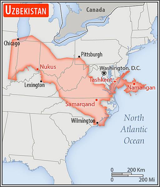
Area comparison map
Area comparison map • CIA World Factbook • 2020
3 photos available
Data sources: World Bank, UN Data • Updated daily •Learn about our data