›››
St. Vincent and the Grenadines
St. Vincent and the Grenadines
Population
100.6K
Rank #194Source: World Bank
Capital
Kingstown
Source: REST Countries
Region
Americas
Latin America & Caribbean
Source: REST Countries
GDP (Nominal)
$1.16B
Rank #184Source: World Bank
Land Area
389 km²
Rank #196Source: REST Countries
Life Expectancy
71.23 yrs
Source: World Bank
Historical Trends
Population Trend (5-Year)
Source: World Bank
GDP Trend (5-Year, Nominal USD)
Source: World Bank
Geography
Area: 389 km²
Landlocked: No
Independent: Yes
Climate: tropical; little seasonal temperature variation; rainy season (May to November)
Terrain: volcanic, mountainous
Elevation: lowest point: Caribbean Sea 0 m highest point: La Soufriere 1,234 m
Natural Hazards: hurricanes; La Soufriere volcano on the island of Saint Vincent is a constant threatvolcanism: La Soufriere (1,234 m) on the island of Saint Vincent last erupted in 1979; the island of Saint Vincent...
Environmental Issues: pollution of coastal waters and shorelines from discharges by pleasure yachts and other effluents; in some areas, pollution is severe enough to make swimming prohibitive; poor land use planning;...
Land Use: agricultural land: 25.6% (2011 est.) forest: 68.7% (2011 est.) other: 5.7% (2011 est.)
Geography Note: the administration of the islands of the Grenadines group is divided between Saint Vincent and the Grenadines and Grenada; Saint Vincent and the Grenadines is comprised of 32 islands and cays
Natural Resources
hydropowerarable land
People & Society
Fertility Rate
1.77
Population
100.6K
Ethnic Groups
African descent (71.2%)mixed (23%)indigenous (3%)East Indian/Indian (1.1%)European (1.5%)other (0.2%)
Religions
Protestant 75% (Pentecostal (27.6%)Anglican (13.9%)Seventh Day Adventist (11.6%)Baptist (8.9%)Methodist (8.7%)Evangelical (3.8%)Salvation Army (0.3%)Presbyterian/Congregational (0.3%)Roman Catholic (6.3%)Rastafarian (1.1%)Jehovah's Witness (0.8%)other (4.7%)none (7.5%)unspecified (4.7%)
Economy
GDP per Capita
$11,501.227
GDP per Capita PPP
21,272.08
(2024)
(2024)
GNI per Capita
11,060
(2024)
(2024)
Gini Index
Not Available
Unemployment
18.093%
(2024)
(2024)
Inflation
3.628%
(2024)
(2024)
Public Debt
Not Available
Energy
Electricity Access
100%
(2023)
(2023)
Renewable Energy
5.1%
(2022)
(2022)
CO₂ Emissions
0.132 Mt
(2024)
(2024)
Energy Intensity
2.43 MJ/$
(2022)
(2022)
Renewable Electricity
15.017%
(2021)
(2021)
Environment
Forest Coverage
73.179% of land
(2023)
(2023)
Communications
Internet Users
75.993%
(2023)
(2023)
Mobile Penetration
101.631%
(2023)
(2023)
Broadband Subscribers
30.494%
(2023)
(2023)
Transportation
Air Transport Freight
Not Available
Container Port Traffic
18,222 TEU
(2020)
(2020)
Airports
N/A
Rail Lines
N/A
Roads Total
N/A
Military
Military Forces
no regular military forces; the Special Services Unit (SSU) is the paramilitary arm of the Royal Saint Vincent and the Grenadines Police Force (RSVPF)
Education
Pre-Primary Enrollment
113.829%
(2020)
(2020)
Primary Enrollment
111.271%
(2023)
(2023)
Secondary Enrollment
125.381%
(2023)
(2023)
Tertiary Enrollment
23.619%
(2015)
(2015)
Education Spending
6.458% of GDP
(2023)
(2023)
Pupil-Teacher Ratio
14.393:1
(2018)
(2018)
Health
Physicians per 1,000
0.938
(2012)
(2012)
Safe Water Access
97.728%
(2018)
(2018)
Safe Drinking Water
Not Available
Under-5 Mortality
10.6 per 1,000
(2023)
(2023)
Maternal Mortality (World Bank)
18.667 per 100,000
(2021)
(2021)
Hospital Beds per 1,000
75.525
(2021)
(2021)
UHC Coverage Index
80
(2023)
(2023)
Measles Immunization
99%
(2024)
(2024)
Social Indicators
Extreme Poverty Rate
Not Available
Food Insecurity
6.1%
(2023)
(2023)
Youth NEET Rate
Not Available
Governance
Women in Government
21.739%
(2024)
(2024)
Voice & Accountability
0.83
(Above Average)
(2023)
(Above Average)
(2023)
Political Stability
1.02
(Strong)
(2023)
(Strong)
(2023)
Government Effectiveness
0.07
(Above Average)
(2023)
(Above Average)
(2023)
Regulatory Quality
0.32
(Above Average)
(2023)
(Above Average)
(2023)
Rule of Law
0.57
(Above Average)
(2023)
(Above Average)
(2023)
Control of Corruption
0.74
(Above Average)
(2023)
(Above Average)
(2023)
Government
Government Type
parliamentary democracy under a constitutional monarchy; a Commonwealth realm
Legal System
English common law
Executive Branch
chief of state: Queen ELIZABETH II (since 6 February 1952); represented by Governor General Susan DOUGAN (since 1 August 2019) head of government: Prime Minister Ralph E. GONSALVES (since 29 March...
Legislative Branch
description: unicameral House of Assembly (23 seats; 15 representatives directly elected in single-seat constituencies by simple majority vote, 6 senators appointed by the governor general, and 2 ex...
Judicial Branch
highest courts: the Eastern Caribbean Supreme Court (ECSC) is the superior court of the Organization of Eastern Caribbean States; the ECSC - headquartered on St. Lucia - consists of the Court of...
National Symbols
Flag Description
three vertical bands of blue (hoist side), gold (double width), and green; the gold band bears three green diamonds arranged in a V pattern, which stands for Vincent; the diamonds recall the islands...
National Symbols
Saint Vincent parrot; national colors: blue, gold, green
National Anthem
name: St. Vincent! Land So Beautiful! lyrics/music: Phyllis Joyce MCCLEAN PUNNETT/Joel Bertram MIGUEL note: adopted 1967
Safety
Homicide Rate
51.321 per 100,000
(2023)
(2023)
Travel Information
Language(s): English
Currency: XCD ($)
Timezone(s): UTC-04:00
Landlocked: No
Independent: Yes
Driving Side: Left
Calling Code: +1
Car Sign: WV
Week Starts: Monday
Photos
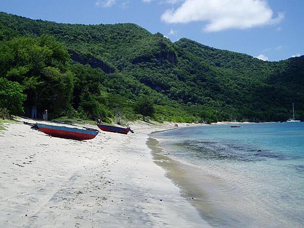
The beach of Union Island, one of the Grenadines of St. Vincent, inhabited by only a few hundred people.
The beach of Union Island, one of the Grenadines of St. Vincent, inhabited by only a few hundred people. • CIA World Factbook • 2020
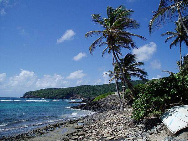
The beach of Bequia, one of the larger islands of the Grenadines of St. Vincent. The object at the lower right is space junk, a piece of a European rocket booster that washed up on the beach.
The beach of Bequia, one of the larger islands of the Grenadines of St. Vincent. The object at the lower right is space junk, a piece of a European rocket booster that washed up on the beach. • CIA World Factbook • 2020
Area comparison map
Area comparison map • CIA World Factbook • 2020
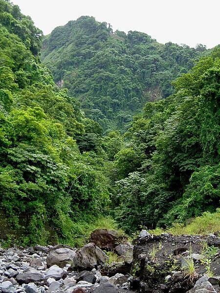
A view of the jungle on St. Vincent, taken from the beach. The rocks in the foreground are the remains of lava flows from a 1979 eruption of La Soufriere volcano.
A view of the jungle on St. Vincent, taken from the beach. The rocks in the foreground are the remains of lava flows from a 1979 eruption of La Soufriere volcano. • CIA World Factbook • 2020
4 photos available
Data sources: World Bank, UN Data • Updated daily •Learn about our data