›››
Vanuatu
Vanuatu
Population
327.8K
Rank #177Source: World Bank
Capital
Port-Vila
Source: REST Countries
Region
Oceania
East Asia & Pacific
Source: REST Countries
GDP (Nominal)
$1.12B
Rank #186Source: World Bank
Land Area
12.2K km²
Rank #159Source: REST Countries
Life Expectancy
71.477 yrs
Source: World Bank
Historical Trends
Population Trend (5-Year)
Source: World Bank
GDP Trend (5-Year, Nominal USD)
Source: World Bank
Geography
Area: 12,189 km²
Landlocked: No
Independent: Yes
Climate: tropical; moderated by southeast trade winds from May to October; moderate rainfall from November to April; may be affected by cyclones from December to April
Terrain: mostly mountainous islands of volcanic origin; narrow coastal plains
Elevation: lowest point: Pacific Ocean 0 m highest point: Tabwemasana 1,877 m
Natural Hazards: tropical cyclones (January to April); volcanic eruption on Aoba (Ambae) island began on 27 November 2005, volcanism also causes minor earthquakes; tsunamisvolcanism: significant volcanic activity...
Environmental Issues: population growth; water pollution, most of the population does not have access to a reliable supply of potable water; inadequate sanitation; deforestation
Land Use: agricultural land: 15.3% (2011 est.) forest: 36.1% (2011 est.) other: 48.6% (2011 est.)
Geography Note: a Y-shaped chain of four main islands and 80 smaller islands; several of the islands have active volcanoes and there are several underwater volcanoes as well
Natural Resources
manganesehardwood forestsfish
People & Society
Fertility Rate
3.60
Population
327.8K
Ethnic Groups
Melanesian (99.2%)non-Melanesian (0.8%)
Religions
Protestant 70% (includes Presbyterian (27.9%)Anglican (15.1%)Seventh Day Adventist (12.5%)Assemblies of God (4.7%)Church of Christ (4.5%)Neil Thomas Ministry (3.1%)and Apostolic (2.2%)Roman Catholic (12.4%)customary beliefs (3.7%)other (12.6%)none (1.1%)unspecified (0.2%)
Economy
GDP per Capita
$3,410.77
GDP per Capita PPP
3,605.607
(2024)
(2024)
GNI per Capita
3,890
(2024)
(2024)
Gini Index
32.3
(2019)
(2019)
Unemployment
4.988%
(2024)
(2024)
Inflation
11.183%
(2023)
(2023)
Public Debt
72.325%
(2023)
(2023)
Energy
Electricity Access
61.6%
(2023)
(2023)
Renewable Energy
25%
(2022)
(2022)
CO₂ Emissions
0.285 Mt
(2024)
(2024)
Energy Intensity
5.04 MJ/$
(2022)
(2022)
Renewable Electricity
25.155%
(2021)
(2021)
Environment
Forest Coverage
36.284% of land
(2023)
(2023)
Protected Areas
0.47% of land
(2009)
(2009)
Communications
Internet Users
45.731%
(2023)
(2023)
Mobile Penetration
89.294%
(2023)
(2023)
Broadband Subscribers
1.233%
(2023)
(2023)
Transportation
Air Transport Freight
30.272 M ton-km
(2023)
(2023)
Container Port Traffic
77,435.86 TEU
(2019)
(2019)
Airports
8,307
Rail Lines
N/A
Roads Total
2,039 km(©IRF)
Military
Military Forces
no regular military forces; Vanuatu Police Force (VPF; includes Vanuatu Mobile Force (VMF) and Police Maritime Wing (VPMW))
Education
Pre-Primary Enrollment
102.606%
(2020)
(2020)
Primary Enrollment
112.492%
(2024)
(2024)
Secondary Enrollment
134.671%
(2023)
(2023)
Tertiary Enrollment
Not Available
Education Spending
7.581% of GDP
(2023)
(2023)
Adult Literacy Rate
87.96%
(2023)
(2023)
Pupil-Teacher Ratio
26.565:1
(2015)
(2015)
Health
Physicians per 1,000
0.164
(2019)
(2019)
Safe Water Access
87.12%
(2024)
(2024)
Safe Drinking Water
19.197%
(2024)
(2024)
Under-5 Mortality
16.8 per 1,000
(2023)
(2023)
Maternal Mortality (World Bank)
15.645 per 100,000
(2021)
(2021)
Hospital Beds per 1,000
66.348
(2021)
(2021)
UHC Coverage Index
52
(2023)
(2023)
Measles Immunization
71%
(2024)
(2024)
Social Indicators
Extreme Poverty Rate
19.5%
(2019)
(2019)
Food Insecurity
7.2%
(2023)
(2023)
Youth NEET Rate
9.679%
(2020)
(2020)
Governance
Women in Government
1.961%
(2024)
(2024)
Voice & Accountability
0.63
(Above Average)
(2023)
(Above Average)
(2023)
Political Stability
0.93
(Above Average)
(2023)
(Above Average)
(2023)
Government Effectiveness
-0.57
(Below Average)
(2023)
(Below Average)
(2023)
Regulatory Quality
-0.12
(Below Average)
(2023)
(Below Average)
(2023)
Rule of Law
0.14
(Above Average)
(2023)
(Above Average)
(2023)
Control of Corruption
-0.01
(Below Average)
(2023)
(Below Average)
(2023)
Government
Government Type
parliamentary republic
Legal System
mixed legal system of English common law, French law, and customary law
Executive Branch
chief of state: President Tallis Obed MOSES (since 6 July 2017) head of government: Prime Minister Bob LOUGHMAN (since 20 April 2020) cabinet: Council of Ministers appointed by the prime minister,...
Legislative Branch
description: unicameral Parliament (52 seats; members directly elected in 8 single-seat and 9 multi-seat constituencies by single non-transferable vote to serve 4-year terms (candidates in multi-seat...
Judicial Branch
highest courts: Court of Appeal (consists of 2 or more judges of the Supreme Court designated by the chief justice); Supreme Court (consists of the chief justice and 6 puisne judges - 3 local and 3...
National Symbols
Flag Description
two equal horizontal bands of red (top) and green with a black isosceles triangle (based on the hoist side) all separated by a black-edged yellow stripe in the shape of a horizontal Y (the two points...
National Symbols
boar's tusk with crossed fern fronds; national colors: red, black, green, yellow
National Anthem
name: "Yumi, Yumi, Yumi" (We, We, We) lyrics/music: Francois Vincent AYSSAV note: adopted 1980; the anthem is written in Bislama, a Creole language that mixes Pidgin English and French
Safety
Homicide Rate
0.335 per 100,000
(2020)
(2020)
Travel Information
Language(s): Bislama, English, French
Currency: VUV (Vt)
Timezone(s): UTC+11:00
Landlocked: No
Independent: Yes
Driving Side: Right
Calling Code: +678
Car Sign: VU
Week Starts: Monday
Photos
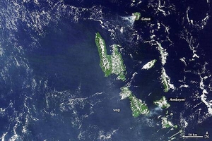
A higher-resolution view of the previous Vanuatu Archipelago image showing the two active volcanoes of Gaua and Ambrym. Vanuatu's two major islands of Espiritu Santo (top) and Malakula (bottom) appear in the center of the image. Photo courtesy of NASA.
A higher-resolution view of the previous Vanuatu Archipelago image showing the two active volcanoes of Gaua and Ambrym. Vanuatu's two major islands of Espiritu Santo (top) and Malakula (bottom) appear in the center of the image. Photo courtesy of NASA. • CIA World Factbook • 2020
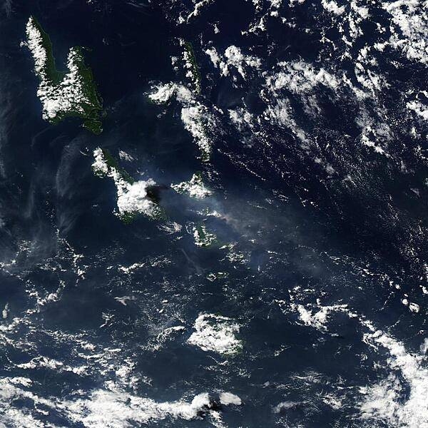
Vanuatu's Lopevi Volcano released a plume on 3 May 2007 (center of photo) that was captured by NASA's Aqua satellite. The US Air Force Weather Agency reported an extensive area of vog resulting from the volcanic eruption. When gases from a volcano - particularly sulfur dioxide - react with oxygen, water, dust, and sunlight, volcanic smog (or vog) results. Besides Lopevi and its neighboring islands, this image shows the volcanic plume blowing westward away from the volcano. The plume appears as a small, mostly opaque puff of gray-beige. The resulting area of vog, which appears as a more transparent, dingy-gray haze, dwarfs the diminutive plume. Lopevi is a stratovolcano composed of alternating layers of solidified lava, hardened ash, and volcanic rocks. One of the island nation's most active volcanoes, this volcanic island is only about 7 km (4 mi) wide. Eruptions have been recorded at Lopevi since the middle of the 19th century. Vanuatu's two major islands of Espiritu Santo and Malakula appear in the upper left. Image courtesy of NASA.
Vanuatu's Lopevi Volcano released a plume on 3 May 2007 (center of photo) that was captured by NASA's Aqua satellite. The US Air Force Weather Agency reported an extensive area of vog resulting from the volcanic eruption. When gases from a volcano - particularly sulfur dioxide - react with oxygen, water, dust, and sunlight, volcanic smog (or vog) results. Besides Lopevi and its neighboring islands, this image shows the volcanic plume blowing westward away from the volcano. The plume appears as a small, mostly opaque puff of gray-beige. The resulting area of vog, which appears as a more transparent, dingy-gray haze, dwarfs the diminutive plume. Lopevi is a stratovolcano composed of alternating layers of solidified lava, hardened ash, and volcanic rocks. One of the island nation's most active volcanoes, this volcanic island is only about 7 km (4 mi) wide. Eruptions have been recorded at Lopevi since the middle of the 19th century. Vanuatu's two major islands of Espiritu Santo and Malakula appear in the upper left. Image courtesy of NASA. • CIA World Factbook • 2020
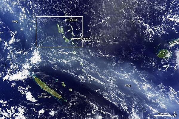
A thick blue haze stretches over the South Pacific archipelago of Vanuatu on the morning of 12 April 2010. The haze is volcanic fog - vog - emitted by the Gaua and Ambrym Volcanoes. Both are known for producing volcanic plumes rich in sulfur dioxide. This gas reacts with moisture in the air to create small droplets (called aerosols) of sulfuric acid, which scatters blue light, coloring the plume. This overview image shows the plume extending for thousands of kilometers to the northwest (upper left) and southeast (lower right) of the islands. Photo courtesy of NASA.
A thick blue haze stretches over the South Pacific archipelago of Vanuatu on the morning of 12 April 2010. The haze is volcanic fog - vog - emitted by the Gaua and Ambrym Volcanoes. Both are known for producing volcanic plumes rich in sulfur dioxide. This gas reacts with moisture in the air to create small droplets (called aerosols) of sulfuric acid, which scatters blue light, coloring the plume. This overview image shows the plume extending for thousands of kilometers to the northwest (upper left) and southeast (lower right) of the islands. Photo courtesy of NASA. • CIA World Factbook • 2020
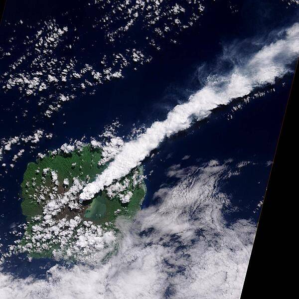
The thick, steam-rich plume from Guau Volcano blows directly northeast in this natural-color satellite image acquired on 24 April 2010. The thick steam is brighter white than the surrounding lower-altitude clouds. Vegetation is green, as is Lake Letas. Vegetation to the south and west of the volcano, damaged by ash and acidic volcanic gases, is dark gray-brown. Photo courtesy of NASA.
The thick, steam-rich plume from Guau Volcano blows directly northeast in this natural-color satellite image acquired on 24 April 2010. The thick steam is brighter white than the surrounding lower-altitude clouds. Vegetation is green, as is Lake Letas. Vegetation to the south and west of the volcano, damaged by ash and acidic volcanic gases, is dark gray-brown. Photo courtesy of NASA. • CIA World Factbook • 2020
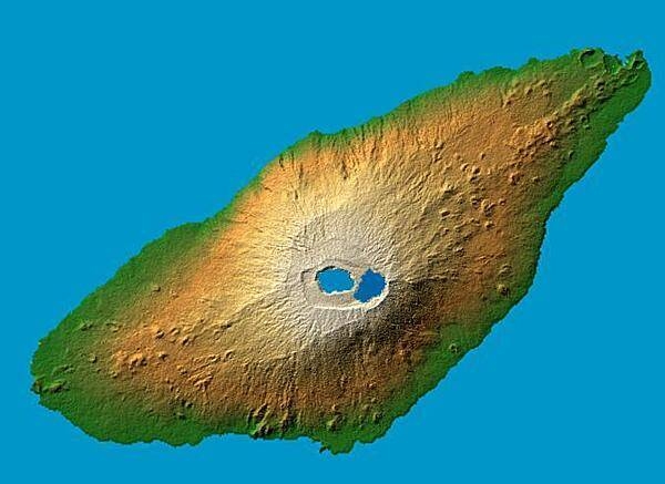
Periodically active volcano Mt. Manaro is the dominant feature in this shaded relief image of Aoba (Ambae) Island, part of the Vanuatu Archipelago located 2,250 km (1,400 mi) northeast of Sydney, Australia. The 1,496 m (4,908 ft) high Hawaiian-style basaltic shield volcano features two lakes within its summit caldera, or crater. Two visualization methods were combined to produce the image: shading and color coding of topographic height. The shade image was derived by computing topographic slope in the northwest-southeast direction, so that northwest slopes appear bright and southeast slopes appear dark. Color coding is directly related to topographic height, with green at the lower elevations, rising through yellow and tan, to white at the highest elevations. Image courtesy of NASA.
Periodically active volcano Mt. Manaro is the dominant feature in this shaded relief image of Aoba (Ambae) Island, part of the Vanuatu Archipelago located 2,250 km (1,400 mi) northeast of Sydney, Australia. The 1,496 m (4,908 ft) high Hawaiian-style basaltic shield volcano features two lakes within its summit caldera, or crater. Two visualization methods were combined to produce the image: shading and color coding of topographic height. The shade image was derived by computing topographic slope in the northwest-southeast direction, so that northwest slopes appear bright and southeast slopes appear dark. Color coding is directly related to topographic height, with green at the lower elevations, rising through yellow and tan, to white at the highest elevations. Image courtesy of NASA. • CIA World Factbook • 2020
5 photos available
Data sources: World Bank, UN Data • Updated daily •Learn about our data