›››
Argentina
Argentina
Population
45.7M
Rank #35Source: World Bank
Capital
Buenos Aires
Source: REST Countries
Region
Americas
Latin America & Caribbean
Source: REST Countries
GDP (Nominal)
$638.37B
Rank #23Source: World Bank
Land Area
2.8M km²
Rank #8Source: REST Countries
Life Expectancy
77.395 yrs
Source: World Bank
Historical Trends
Population Trend (5-Year)
Source: World Bank
GDP Trend (5-Year, Nominal USD)
Source: World Bank
Geography
Area: 2,780,400 km²
Landlocked: No
Independent: Yes
Climate: mostly temperate; arid in southeast; subantarctic in southwest
Terrain: rich plains of the Pampas in northern half, flat to rolling plateau of Patagonia in south, rugged Andes along western border
Elevation: mean elevation: 595 m lowest point: Laguna del Carbon (located between Puerto San Julian and Comandante Luis Piedra Buena in the province of Santa Cruz) -105 m highest point: Cerro Aconcagua (located...
Natural Hazards: San Miguel de Tucuman and Mendoza areas in the Andes subject to earthquakes; pamperos are violent windstorms that can strike the pampas and northeast; heavy flooding in some areasvolcanism: volcanic...
Environmental Issues: environmental problems (urban and rural) typical of an industrializing economy such as deforestation, soil degradation (erosion, salinization), desertification, air pollution, and water pollution...
Land Use: agricultural land: 53.9% (2016 est.) forest: 10.7% (2016 est.) other: 35.4% (2016 est.)
Geography Note: second-largest country in South America (after Brazil); strategic location relative to sea lanes between the South Atlantic and the South Pacific Oceans (Strait of Magellan, Beagle Channel, Drake...
Natural Resources
fertile plains of the pampasleadzinctincopperiron oremanganesepetroleumuraniumarable land
People & Society
Fertility Rate
1.50
Population
45.7M
Ethnic Groups
European (mostly Spanish and Italian descent) and mestizo (mixed European and Amerindian ancestry) (97.2%)Amerindian (2.4%)African (0.4%)
Religions
nominally Roman Catholic 92% (less than (20%)Protestant (2%)Jewish (2%)other (4%)
Economy
GDP per Capita
$13,969.784
GDP per Capita PPP
30,431.193
(2024)
(2024)
GNI per Capita
13,530
(2024)
(2024)
Gini Index
42.4
(2024)
(2024)
Unemployment
7.15%
(2024)
(2024)
Inflation
72.431%
(2022)
(2022)
Public Debt
Not Available
Energy
Electricity Access
100%
(2023)
(2023)
Renewable Energy
9.2%
(2021)
(2021)
CO₂ Emissions
183.272 Mt
(2024)
(2024)
Energy Intensity
3.29 MJ/$
(2022)
(2022)
Renewable Electricity
25.536%
(2021)
(2021)
Environment
Forest Coverage
10.321% of land
(2023)
(2023)
Communications
Internet Users
89.667%
(2024)
(2024)
Mobile Penetration
137.706%
(2023)
(2023)
Broadband Subscribers
25.358%
(2023)
(2023)
Transportation
Air Transport Freight
136.476 M ton-km
(2023)
(2023)
Container Port Traffic
1,667,161 TEU
(2022)
(2022)
Airports
156,614
Rail Lines
17,866 km
Roads Total
204,663 km(©IRF)
Military
Military Forces
Armed Forces of the Argentine Republic (Fuerzas Armadas de la República Argentina): Argentine Army (Ejercito Argentino), Navy of the Argentine Republic (Armada Republica; includes naval aviation and...
Personnel Strength
Argentina's armed forces have approximately 75,000 (45,000 Army; 17,000 Navy; 13,000 Air Force); est. 18,000 Gendarmerie
Military Expenditure (USD)
$4.18B
Military Expenditure (% of GDP)
0.62%
Military Expenditure History
0.7% of GDP (2019) 0.7% of GDP (2018) 0.9% of GDP (2017) 0.8% of GDP (2016) 0.9% of GDP (2015)
Deployments
250 Cyprus (UNFICYP) (2020)
Equipment & Inventories
the inventory of Argentina's armed forces is a mix of domestically-produced and mostly older imported weapons, largely from Europe and the US; since 2010, France and the US are the leading suppliers...
Service Age & Obligation
18-24 years of age for voluntary military service (18-21 requires parental consent); no conscription; if the number of volunteers fails to meet the quota of recruits for a particular year, Congress...
Education
Pre-Primary Enrollment
76.187%
(2020)
(2020)
Primary Enrollment
102.535%
(2023)
(2023)
Secondary Enrollment
105.575%
(2023)
(2023)
Tertiary Enrollment
107.823%
(2023)
(2023)
Education Spending
5.898% of GDP
(2023)
(2023)
Adult Literacy Rate
99.14%
(2020)
(2020)
Pupil-Teacher Ratio
Not Available
Health
Physicians per 1,000
5.106
(2023)
(2023)
Safe Water Access
99.041%
(2016)
(2016)
Safe Drinking Water
Not Available
Under-5 Mortality
9.6 per 1,000
(2023)
(2023)
Maternal Mortality (World Bank)
19.572 per 100,000
(2021)
(2021)
Hospital Beds per 1,000
77.578
(2021)
(2021)
UHC Coverage Index
80
(2023)
(2023)
Measles Immunization
75%
(2024)
(2024)
Social Indicators
Extreme Poverty Rate
1%
(2024)
(2024)
Food Insecurity
3.4%
(2023)
(2023)
Youth NEET Rate
4.968%
(2024)
(2024)
Governance
Women in Government
42.412%
(2024)
(2024)
Voice & Accountability
0.53
(Above Average)
(2023)
(Above Average)
(2023)
Political Stability
-0.13
(Below Average)
(2023)
(Below Average)
(2023)
Government Effectiveness
-0.38
(Below Average)
(2023)
(Below Average)
(2023)
Regulatory Quality
-0.48
(Below Average)
(2023)
(Below Average)
(2023)
Rule of Law
-0.41
(Below Average)
(2023)
(Below Average)
(2023)
Control of Corruption
-0.36
(Below Average)
(2023)
(Below Average)
(2023)
Government
Government Type
presidential republic
Legal System
civil law system based on West European legal systems; note - in mid-2015, Argentina adopted a new civil code, replacing the old one in force since 1871
Executive Branch
chief of state: President Alberto Angel FERNANDEZ (since 10 December 2019); Vice President Cristina FERNANDEZ DE KIRCHNER (since 10 December 2019); note - the president is both chief of state and...
Legislative Branch
description: bicameral National Congress or Congreso Nacional consists of:Senate (72 seats; members directly elected in multi-seat constituencies by simple majority vote to serve 6-year terms with...
Judicial Branch
highest courts: Supreme Court or Corte Suprema (consists of the court president, vice president, and 5 justices) judge selection and term of office: justices nominated by the president and approved...
International Organizations
National Symbols
Flag Description
three equal horizontal bands of sky blue (top), white, and sky blue; centered in the white band is a radiant yellow sun with a human face (delineated in brown) known as the Sun of May; the colors...
National Symbols
Sun of May (a sun-with-face symbol); national colors: sky blue, white
National Anthem
name: "Himno Nacional Argentino" (Argentine National Anthem) lyrics/music: Vicente LOPEZ y PLANES/Jose Blas PARERA note: adopted 1813; Vicente LOPEZ was inspired to write the anthem after watching a...
Safety
Homicide Rate
4.493 per 100,000
(2023)
(2023)
Travel Information
Language(s): Guaraní, Spanish
Currency: ARS ($)
Timezone(s): UTC-03:00
Landlocked: No
Independent: Yes
Driving Side: Right
Calling Code: +54
Car Sign: RA
Week Starts: Monday
Photos
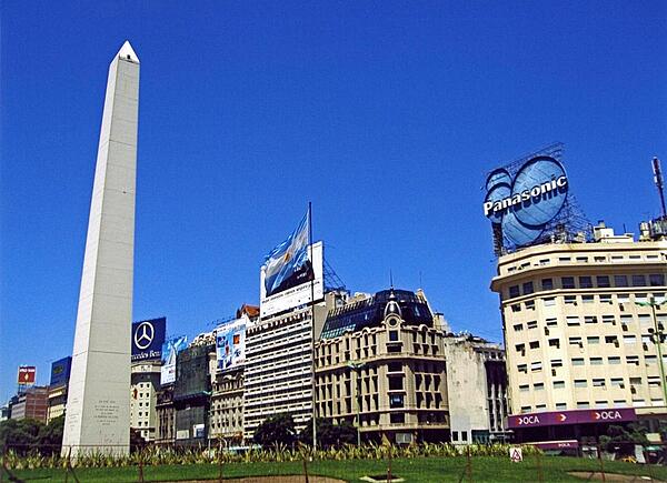
The Obelisk (El Obelisco) along Nueve de Julio Avenue in Buenos Aires. The thoroughfare, named after Argentina's independence day (9 July 1816), is generally considered the widest avenue in the world. The Obelisk, built in 1936, measures 67 meters high (220 feet) and commemorates the founding of the city.
The Obelisk (El Obelisco) along Nueve de Julio Avenue in Buenos Aires. The thoroughfare, named after Argentina's independence day (9 July 1816), is generally considered the widest avenue in the world. The Obelisk, built in 1936, measures 67 meters high (220 feet) and commemorates the founding of the city. • CIA World Factbook • 2020
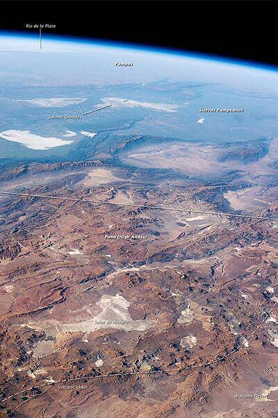
This panorama looking southeast across the South American continent was taken from the International Space Station almost directly over the Atacama Desert near Chile's Pacific coast. The high plains (3000-5000 m, 13,000-19,000 ft) of the Andes Mountains, also known as the Puna, appear in the foreground, with a line of young volcanoes (dashed line) facing the much lower Atacama Desert (1000-2000 m elevation). Several salt-crusted dry lakes (known as salars in Spanish) occupy the basins between major thrust faults in the Puna. Salar de Arizaro (foreground) is the largest of the dry lakes in this view. The Atlantic Ocean coastline, where Argentina's capital city of Buenos Aires sits along the Río de la Plata, is dimly visible at image top left. Near image center, the transition (solid line) between two distinct geological zones, the Puna and the Sierras Pampeanas, creates a striking landscape contrast. Compared to the Puna, the Sierras Pampeanas mountains are lower in elevation and have fewer young volcanoes. Sharp-crested ridges are separated by wide, low valleys in this region. The Salinas Grandes - ephemeral shallow salt lakes - occupies one of these valleys. The general color change from reds and browns in the foreground to blues and greens in the upper part of the image reflects the major climatic regions: the deserts of the Atacama and Puna versus the grassy plains of central Argentina, where rainfall is sufficient to promote lush prairie grass, known locally as the pampas. The Salinas Grandes mark an intermediate, semiarid region. Image courtesy of NASA.
This panorama looking southeast across the South American continent was taken from the International Space Station almost directly over the Atacama Desert near Chile's Pacific coast. The high plains (3000-5000 m, 13,000-19,000 ft) of the Andes Mountains, also known as the Puna, appear in the foreground, with a line of young volcanoes (dashed line) facing the much lower Atacama Desert (1000-2000 m elevation). Several salt-crusted dry lakes (known as salars in Spanish) occupy the basins between major thrust faults in the Puna. Salar de Arizaro (foreground) is the largest of the dry lakes in this view. The Atlantic Ocean coastline, where Argentina's capital city of Buenos Aires sits along the Río de la Plata, is dimly visible at image top left. Near image center, the transition (solid line) between two distinct geological zones, the Puna and the Sierras Pampeanas, creates a striking landscape contrast. Compared to the Puna, the Sierras Pampeanas mountains are lower in elevation and have fewer young volcanoes. Sharp-crested ridges are separated by wide, low valleys in this region. The Salinas Grandes - ephemeral shallow salt lakes - occupies one of these valleys. The general color change from reds and browns in the foreground to blues and greens in the upper part of the image reflects the major climatic regions: the deserts of the Atacama and Puna versus the grassy plains of central Argentina, where rainfall is sufficient to promote lush prairie grass, known locally as the pampas. The Salinas Grandes mark an intermediate, semiarid region. Image courtesy of NASA. • CIA World Factbook • 2020
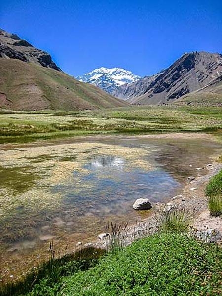
A view of Laguna de Horcones at 2,950 m in Parque Provincial Aconcagua, Mendoza, Argentina. Snow covered Aconcagua, the largest mountain in the Western Hemisphere at 6,962 m, stands prominently in the background.
A view of Laguna de Horcones at 2,950 m in Parque Provincial Aconcagua, Mendoza, Argentina. Snow covered Aconcagua, the largest mountain in the Western Hemisphere at 6,962 m, stands prominently in the background. • CIA World Factbook • 2020
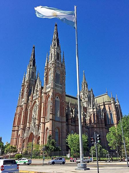
Opened as a cathedral in 1932 and architecturally completed in 2000, the Cathedral of La Plata is the largest church in Argentina and one of the top seven largest in the Western Hemisphere. At a height of 112m, it is among the six tallest churches in the Americas.
Opened as a cathedral in 1932 and architecturally completed in 2000, the Cathedral of La Plata is the largest church in Argentina and one of the top seven largest in the Western Hemisphere. At a height of 112m, it is among the six tallest churches in the Americas. • CIA World Factbook • 2020
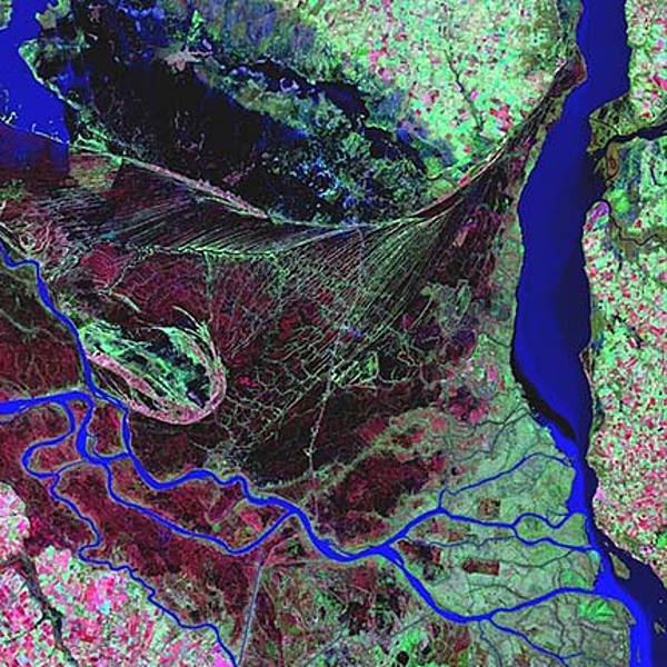
The Parana is the second longest river is South America; its delta is a huge forested marshland about 32 km (20 mi) northeast of Buenos Aires. The area is a very popular tourist destination with guided boat tours that venture into this vast labyrinth of marsh and trees. The Parana River delta is one of the world's greatest bird-watching destinations. This false color satellite image highlights the striking contrast between dense forest and wetland marshes (deep red and violet), and the winding blue ribbon of the Parana River. The large north-south-trending water body on the right is the Uruguay River. Image courtesy of USGS.
The Parana is the second longest river is South America; its delta is a huge forested marshland about 32 km (20 mi) northeast of Buenos Aires. The area is a very popular tourist destination with guided boat tours that venture into this vast labyrinth of marsh and trees. The Parana River delta is one of the world's greatest bird-watching destinations. This false color satellite image highlights the striking contrast between dense forest and wetland marshes (deep red and violet), and the winding blue ribbon of the Parana River. The large north-south-trending water body on the right is the Uruguay River. Image courtesy of USGS. • CIA World Factbook • 2020
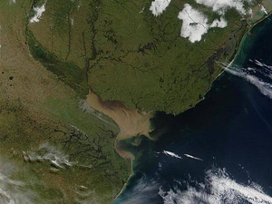
The Rio Parana in Argentina (running north-south through image center) appears brown from its sediment; it eventually drains into the Delta del Parana and the Rio de la Plata estuary. Where the Rio de la Plata empties into the Atlantic, the brown, sediment-filled river water mixes with clearer ocean water and creates swirls and cloudy formations. Visible in this image (in gray) is Buenos Aires, the capital city of Argentina, located where the Rio Parana meets the Rio de la Plata. Montevideo, Uruguay's capital, is located on the opposite side of the Rio de la Plata. Photo courtesy of NASA.
The Rio Parana in Argentina (running north-south through image center) appears brown from its sediment; it eventually drains into the Delta del Parana and the Rio de la Plata estuary. Where the Rio de la Plata empties into the Atlantic, the brown, sediment-filled river water mixes with clearer ocean water and creates swirls and cloudy formations. Visible in this image (in gray) is Buenos Aires, the capital city of Argentina, located where the Rio Parana meets the Rio de la Plata. Montevideo, Uruguay's capital, is located on the opposite side of the Rio de la Plata. Photo courtesy of NASA. • CIA World Factbook • 2020
22 photos available
View All Photos→Data sources: World Bank, UN Data • Updated daily •Learn about our data