›››
Argentina — Media Gallery
22 items available (flags, maps, photos)
Photos
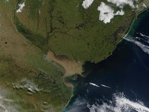
The Rio Parana in Argentina (running north-south through image center) appears brown from its sediment; it eventually drains into the Delta del Parana and the Rio de la Plata estuary. Where the Rio de la Plata empties into the Atlantic, the brown, sediment-filled river water mixes with clearer ocean water and creates swirls and cloudy formations. Visible in this image (in gray) is Buenos Aires, the capital city of Argentina, located where the Rio Parana meets the Rio de la Plata. Montevideo, Uruguay's capital, is located on the opposite side of the Rio de la Plata. Photo courtesy of NASA.
The Rio Parana in Argentina (running north-south through image center) appears brown from its sediment; it eventually drains into the Delta del Parana and the Rio de la Plata estuary. Where the Rio de la Plata empties into the Atlantic, the brown, sediment-filled river water mixes with clearer ocean water and creates swirls and cloudy formations. Visible in this image (in gray) is Buenos Aires, the capital city of Argentina, located where the Rio Parana meets the Rio de la Plata. Montevideo, Uruguay's capital, is located on the opposite side of the Rio de la Plata. Photo courtesy of NASA. • CIA World Factbook • 2020
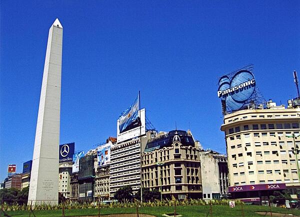
The Obelisk (El Obelisco) along Nueve de Julio Avenue in Buenos Aires. The thoroughfare, named after Argentina's independence day (9 July 1816), is generally considered the widest avenue in the world. The Obelisk, built in 1936, measures 67 meters high (220 feet) and commemorates the founding of the city.
The Obelisk (El Obelisco) along Nueve de Julio Avenue in Buenos Aires. The thoroughfare, named after Argentina's independence day (9 July 1816), is generally considered the widest avenue in the world. The Obelisk, built in 1936, measures 67 meters high (220 feet) and commemorates the founding of the city. • CIA World Factbook • 2020
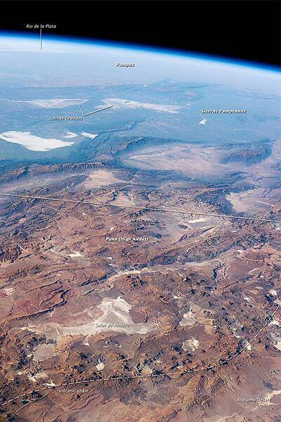
This panorama looking southeast across the South American continent was taken from the International Space Station almost directly over the Atacama Desert near Chile's Pacific coast. The high plains (3000-5000 m, 13,000-19,000 ft) of the Andes Mountains, also known as the Puna, appear in the foreground, with a line of young volcanoes (dashed line) facing the much lower Atacama Desert (1000-2000 m elevation). Several salt-crusted dry lakes (known as salars in Spanish) occupy the basins between major thrust faults in the Puna. Salar de Arizaro (foreground) is the largest of the dry lakes in this view. The Atlantic Ocean coastline, where Argentina's capital city of Buenos Aires sits along the Río de la Plata, is dimly visible at image top left. Near image center, the transition (solid line) between two distinct geological zones, the Puna and the Sierras Pampeanas, creates a striking landscape contrast. Compared to the Puna, the Sierras Pampeanas mountains are lower in elevation and have fewer young volcanoes. Sharp-crested ridges are separated by wide, low valleys in this region. The Salinas Grandes - ephemeral shallow salt lakes - occupies one of these valleys. The general color change from reds and browns in the foreground to blues and greens in the upper part of the image reflects the major climatic regions: the deserts of the Atacama and Puna versus the grassy plains of central Argentina, where rainfall is sufficient to promote lush prairie grass, known locally as the pampas. The Salinas Grandes mark an intermediate, semiarid region. Image courtesy of NASA.
This panorama looking southeast across the South American continent was taken from the International Space Station almost directly over the Atacama Desert near Chile's Pacific coast. The high plains (3000-5000 m, 13,000-19,000 ft) of the Andes Mountains, also known as the Puna, appear in the foreground, with a line of young volcanoes (dashed line) facing the much lower Atacama Desert (1000-2000 m elevation). Several salt-crusted dry lakes (known as salars in Spanish) occupy the basins between major thrust faults in the Puna. Salar de Arizaro (foreground) is the largest of the dry lakes in this view. The Atlantic Ocean coastline, where Argentina's capital city of Buenos Aires sits along the Río de la Plata, is dimly visible at image top left. Near image center, the transition (solid line) between two distinct geological zones, the Puna and the Sierras Pampeanas, creates a striking landscape contrast. Compared to the Puna, the Sierras Pampeanas mountains are lower in elevation and have fewer young volcanoes. Sharp-crested ridges are separated by wide, low valleys in this region. The Salinas Grandes - ephemeral shallow salt lakes - occupies one of these valleys. The general color change from reds and browns in the foreground to blues and greens in the upper part of the image reflects the major climatic regions: the deserts of the Atacama and Puna versus the grassy plains of central Argentina, where rainfall is sufficient to promote lush prairie grass, known locally as the pampas. The Salinas Grandes mark an intermediate, semiarid region. Image courtesy of NASA. • CIA World Factbook • 2020
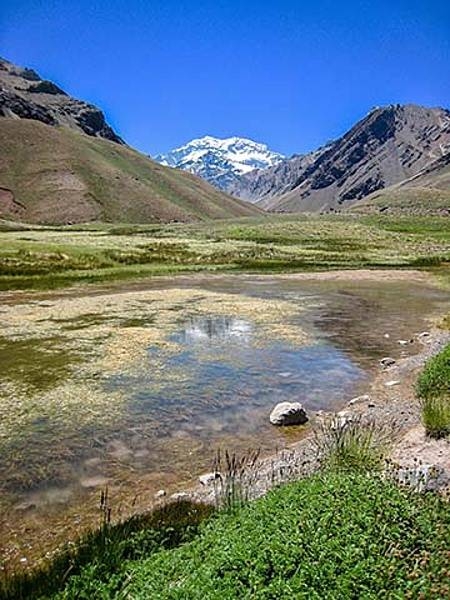
A view of Laguna de Horcones at 2,950 m in Parque Provincial Aconcagua, Mendoza, Argentina. Snow covered Aconcagua, the largest mountain in the Western Hemisphere at 6,962 m, stands prominently in the background.
A view of Laguna de Horcones at 2,950 m in Parque Provincial Aconcagua, Mendoza, Argentina. Snow covered Aconcagua, the largest mountain in the Western Hemisphere at 6,962 m, stands prominently in the background. • CIA World Factbook • 2020
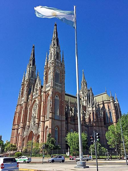
Opened as a cathedral in 1932 and architecturally completed in 2000, the Cathedral of La Plata is the largest church in Argentina and one of the top seven largest in the Western Hemisphere. At a height of 112m, it is among the six tallest churches in the Americas.
Opened as a cathedral in 1932 and architecturally completed in 2000, the Cathedral of La Plata is the largest church in Argentina and one of the top seven largest in the Western Hemisphere. At a height of 112m, it is among the six tallest churches in the Americas. • CIA World Factbook • 2020
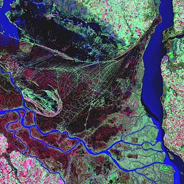
The Parana is the second longest river is South America; its delta is a huge forested marshland about 32 km (20 mi) northeast of Buenos Aires. The area is a very popular tourist destination with guided boat tours that venture into this vast labyrinth of marsh and trees. The Parana River delta is one of the world's greatest bird-watching destinations. This false color satellite image highlights the striking contrast between dense forest and wetland marshes (deep red and violet), and the winding blue ribbon of the Parana River. The large north-south-trending water body on the right is the Uruguay River. Image courtesy of USGS.
The Parana is the second longest river is South America; its delta is a huge forested marshland about 32 km (20 mi) northeast of Buenos Aires. The area is a very popular tourist destination with guided boat tours that venture into this vast labyrinth of marsh and trees. The Parana River delta is one of the world's greatest bird-watching destinations. This false color satellite image highlights the striking contrast between dense forest and wetland marshes (deep red and violet), and the winding blue ribbon of the Parana River. The large north-south-trending water body on the right is the Uruguay River. Image courtesy of USGS. • CIA World Factbook • 2020
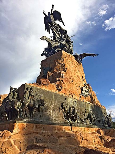
Monument to the Army of the Andes situated atop Cerro de la Gloria (Glory Hill) in the city of Mendoza, Argentina. It was from Mendoza in January 1817 that the Army of the Andes - a military force created by the United Provinces of the Rio de la Plata (Argentina) and led by General Jose de San Martin - crossed the Andes to free Chile from Spanish rule. The force was bolstered by Chilean troops under the command of Bernardo O’Higgins. After a 25-day trek across the mountains, during which perhaps one-third of the troops perished, the combined Argentine and Chilean army successfully defeated the Spanish at the Battle of Chacabuco. The monument, designed by Uruguayan sculptor Juan Manuel Ferrari, was dedicated on 12 February 1914, the 97th anniversary of the battle
Monument to the Army of the Andes situated atop Cerro de la Gloria (Glory Hill) in the city of Mendoza, Argentina. It was from Mendoza in January 1817 that the Army of the Andes - a military force created by the United Provinces of the Rio de la Plata (Argentina) and led by General Jose de San Martin - crossed the Andes to free Chile from Spanish rule. The force was bolstered by Chilean troops under the command of Bernardo O’Higgins. After a 25-day trek across the mountains, during which perhaps one-third of the troops perished, the combined Argentine and Chilean army successfully defeated the Spanish at the Battle of Chacabuco. The monument, designed by Uruguayan sculptor Juan Manuel Ferrari, was dedicated on 12 February 1914, the 97th anniversary of the battle • CIA World Factbook • 2020
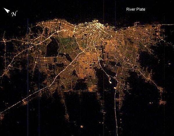
Buenos Aires at night. The brightness of the lights reflects the density of the urban population, which declines to blackness in the farmlands that surround the city. The brightest area is the old part of the city centered on the port and the presidential palace. The blackest part of the scene is the River Plate, the great estuary of the Atlantic Ocean on which this port city is located. The widest city thoroughfare in the world - the Avenida 9 de Julio - is the brightest line in the downtown cluster. It appears as the longest north-south strip just inland of the port. Image courtesy of NASA.
Buenos Aires at night. The brightness of the lights reflects the density of the urban population, which declines to blackness in the farmlands that surround the city. The brightest area is the old part of the city centered on the port and the presidential palace. The blackest part of the scene is the River Plate, the great estuary of the Atlantic Ocean on which this port city is located. The widest city thoroughfare in the world - the Avenida 9 de Julio - is the brightest line in the downtown cluster. It appears as the longest north-south strip just inland of the port. Image courtesy of NASA. • CIA World Factbook • 2020
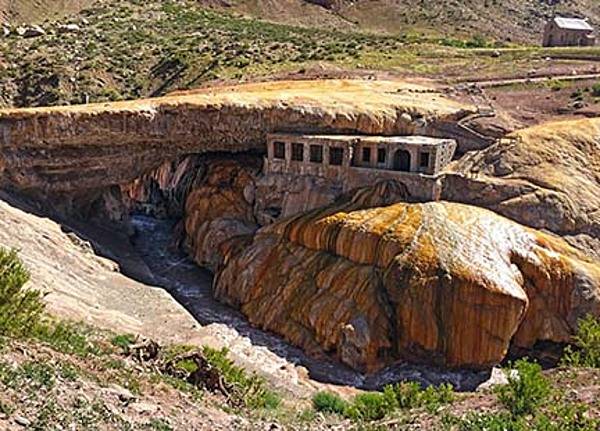
Puente del Inca, or "The Inca Bridge" is a natural bridge that spans across the Cuevas River in the Province of Mendoza, Argentina. Mineral deposits from hot springs have led to colorful shades of red and yellow on the face of the rocks. Though the area has been known since pre-Columbian times, it was famously visited and described by Charles Darwin in 1835.
Puente del Inca, or "The Inca Bridge" is a natural bridge that spans across the Cuevas River in the Province of Mendoza, Argentina. Mineral deposits from hot springs have led to colorful shades of red and yellow on the face of the rocks. Though the area has been known since pre-Columbian times, it was famously visited and described by Charles Darwin in 1835. • CIA World Factbook • 2020
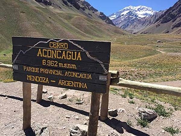
Mount Aconcagua, located in the Province of Mendoza, rises to a height of 6,962 m. It is the tallest mountain in the Western Hemisphere and the tallest mountain outside of Asia. This photo was taken at an elevation of just under 3,000 m on a trail that leads to Confluencia, the first Aconcagua base camp.
Mount Aconcagua, located in the Province of Mendoza, rises to a height of 6,962 m. It is the tallest mountain in the Western Hemisphere and the tallest mountain outside of Asia. This photo was taken at an elevation of just under 3,000 m on a trail that leads to Confluencia, the first Aconcagua base camp. • CIA World Factbook • 2020
CIA World Factbook • 2020
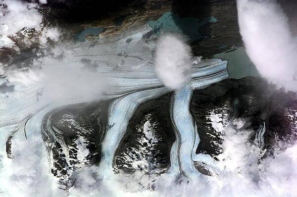
The Upsala Glacier in Argentina - here viewed from the International Space Station - is the third largest glacier of the Southern Patagonian Ice Field with an estimated area of over 800 sq km. This long, north-south oriented river of ice terminates in the northern arm of Lake Argentino. Photo courtesy of NASA.
The Upsala Glacier in Argentina - here viewed from the International Space Station - is the third largest glacier of the Southern Patagonian Ice Field with an estimated area of over 800 sq km. This long, north-south oriented river of ice terminates in the northern arm of Lake Argentino. Photo courtesy of NASA. • CIA World Factbook • 2020
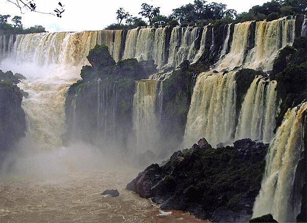
Comprised of over 275 separate waterfalls, Iguazu Falls straddles the border between Argentina and Brazil.
Comprised of over 275 separate waterfalls, Iguazu Falls straddles the border between Argentina and Brazil. • CIA World Factbook • 2020
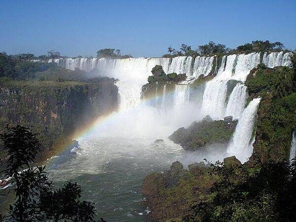
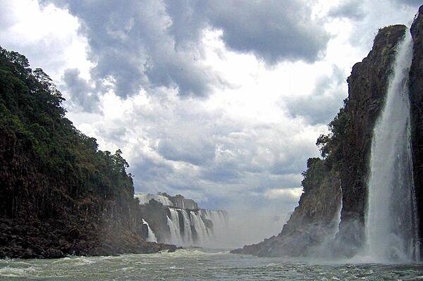
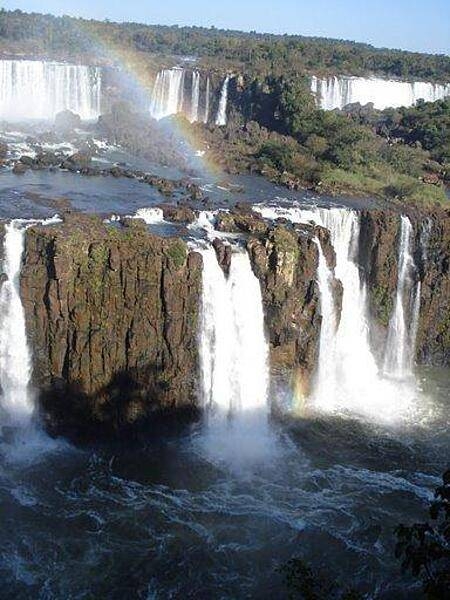
Iguazu Falls is located on the border between Argentina and Brazil. Approximately 2.7 km (1.7 mi) in width and reaching a maximum height of 81 m, about 2/3 of Iguazu Falls is in Argentina and 1/3 is in Brazil. This photo was taken from the Argentine side.
Iguazu Falls is located on the border between Argentina and Brazil. Approximately 2.7 km (1.7 mi) in width and reaching a maximum height of 81 m, about 2/3 of Iguazu Falls is in Argentina and 1/3 is in Brazil. This photo was taken from the Argentine side. • CIA World Factbook • 2020
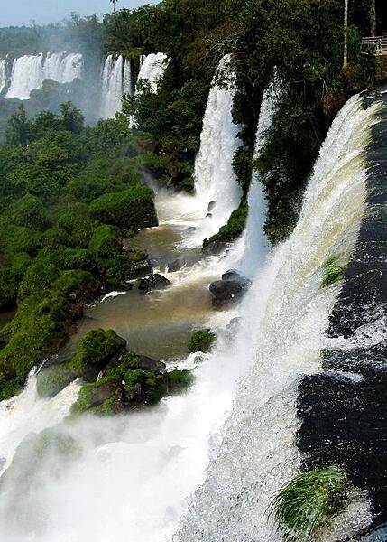
Another view of Iguazu Falls.
Another view of Iguazu Falls. • CIA World Factbook • 2020

A Gaucho (Argentine cowboy) driving a carriage across the pampas. The pampas are a vast, fertile lowland plain found mostly in Argentina, but extending into Uruguay and southernmost Brazil. Vegetation is predominantly composed of grasses; trees are scattered or even absent in places. Important for cattle ranching and farming, the region contains rich topsoils that in places are up to 300 m (1,000 ft) in depth.
A Gaucho (Argentine cowboy) driving a carriage across the pampas. The pampas are a vast, fertile lowland plain found mostly in Argentina, but extending into Uruguay and southernmost Brazil. Vegetation is predominantly composed of grasses; trees are scattered or even absent in places. Important for cattle ranching and farming, the region contains rich topsoils that in places are up to 300 m (1,000 ft) in depth. • CIA World Factbook • 2020
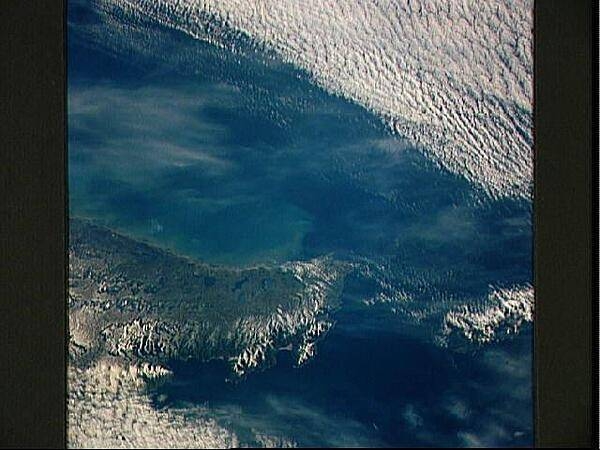
The Mitre Peninsula is the easternmost tip of Tierra del Fuego, Argentina. Early winter snow may be seen on this south tip of the Andes Mountains. These same mountains continue underwater to Antarctica. The Strait of Magellan, separating the South American mainland from Tierra del Fuego, is off the scene to the north and west, but the Strait of Le Maire, separating Tierra del Fuego from the Isla de los Estados may be seen off to the east (right). Image courtesy of NASA.
The Mitre Peninsula is the easternmost tip of Tierra del Fuego, Argentina. Early winter snow may be seen on this south tip of the Andes Mountains. These same mountains continue underwater to Antarctica. The Strait of Magellan, separating the South American mainland from Tierra del Fuego, is off the scene to the north and west, but the Strait of Le Maire, separating Tierra del Fuego from the Isla de los Estados may be seen off to the east (right). Image courtesy of NASA. • CIA World Factbook • 2020
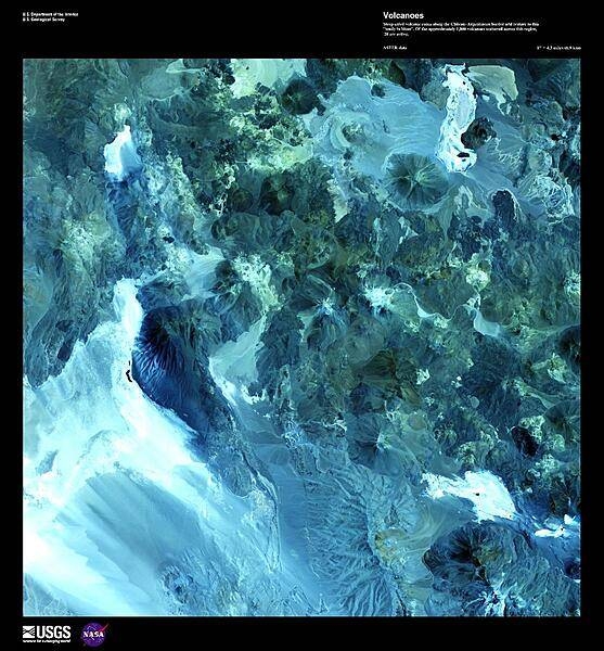
Steep-sided volcanic cones along the Andes on the Chilean-Argentinean border add texture to this false-color satellite image. Of approximately 1,800 volcanoes scattered across this region, 28 are active and form part of the Andean volcanic belt that runs down the length of South America. For more information on other active volcanoes in the region, see the Natural hazards - volcanism subfield in the Geography section under either Chile or Argentina. Image courtesy of USGS.
Steep-sided volcanic cones along the Andes on the Chilean-Argentinean border add texture to this false-color satellite image. Of approximately 1,800 volcanoes scattered across this region, 28 are active and form part of the Andean volcanic belt that runs down the length of South America. For more information on other active volcanoes in the region, see the Natural hazards - volcanism subfield in the Geography section under either Chile or Argentina. Image courtesy of USGS. • CIA World Factbook • 2020
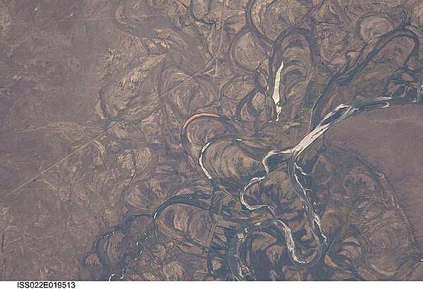
The Rio Negro in Patagonia is recognizable from space as one of the most meandering rivers in South America. This phenomenon is well illustrated in this view, where the entire river floodplain (approximately 10 km (6 mi) wide) is covered with curved relics of channels known as meander scars. The main channel of the river, flowing south at this point 60 km (36 mi) south of the city of Choele Choel (not shown) appears in partial sun glint at right. Sun glint occurs when light is reflected off a water surface directly back towards the viewer, imparting a silvery sheen to those areas. When meander scars contain water they are known as oxbow lakes, some of which are also highlighted by sun glint in the image. Meander scars show the numerous past positions of river bends, produced as the river snaked across the plain in the very recent geological past. The Rio Negro is a dramatic example of how mobile a river can be. The orange tint to the water in one of the oxbow lakes (center) could result from orange salt-loving algae. Image courtesy of NASA.
The Rio Negro in Patagonia is recognizable from space as one of the most meandering rivers in South America. This phenomenon is well illustrated in this view, where the entire river floodplain (approximately 10 km (6 mi) wide) is covered with curved relics of channels known as meander scars. The main channel of the river, flowing south at this point 60 km (36 mi) south of the city of Choele Choel (not shown) appears in partial sun glint at right. Sun glint occurs when light is reflected off a water surface directly back towards the viewer, imparting a silvery sheen to those areas. When meander scars contain water they are known as oxbow lakes, some of which are also highlighted by sun glint in the image. Meander scars show the numerous past positions of river bends, produced as the river snaked across the plain in the very recent geological past. The Rio Negro is a dramatic example of how mobile a river can be. The orange tint to the water in one of the oxbow lakes (center) could result from orange salt-loving algae. Image courtesy of NASA. • CIA World Factbook • 2020
Ushuaia, the southernmost point in Argentina.
Ushuaia, the southernmost point in Argentina. • CIA World Factbook • 2020
CIA World Factbook • 2020
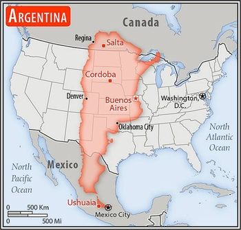
Area comparison map
Area comparison map • CIA World Factbook • 2020
Media source: CIA World Factbook (2020) — Public Domain