›››
Australia
Australia
Population
27.2M
Rank #54Source: World Bank
Capital
Canberra
Source: REST Countries
Region
Oceania
East Asia & Pacific
Source: REST Countries
GDP (Nominal)
$1.76T
Rank #14Source: World Bank
Land Area
7.7M km²
Rank #6Source: REST Countries
Life Expectancy
83.051 yrs
Source: World Bank
Historical Trends
Population Trend (5-Year)
Source: World Bank
GDP Trend (5-Year, Nominal USD)
Source: World Bank
Geography
Area: 7,692,024 km²
Landlocked: No
Independent: Yes
Climate: generally arid to semiarid; temperate in south and east; tropical in north
Terrain: mostly low plateau with deserts; fertile plain in southeast
Elevation: mean elevation: 330 m lowest point: Lake Eyre -15 m highest point: Mount Kosciuszko 2,228 m
Natural Hazards: cyclones along the coast; severe droughts; forest firesvolcanism: volcanic activity on Heard and McDonald Islands
Environmental Issues: soil erosion from overgrazing, deforestation, industrial development, urbanization, and poor farming practices; limited natural freshwater resources; soil salinity rising due to the use of poor...
Land Use: agricultural land: 52.9% (2016 est.) forest: 16.2% (2016 est.) other: 30.9% (2016 est.)
Geography Note: note 1: world's smallest continent but sixth-largest country; the largest country in Oceania, the largest country entirely in the Southern Hemisphere, and the largest country without land borders;...
Natural Resources
aluminacoaliron orecoppertingoldsilveruraniumnickeltungsten
People & Society
Fertility Rate
1.50
Population
27.2M
Ethnic Groups
English (25.9%)Australian (25.4%)Irish (7.5%)Scottish (6.4%)Italian (3.3%)German (3.2%)Chinese (3.1%)Indian (1.4%)Greek (1.4%)Dutch (1.2%)other 15.8% (includes Australian aboriginal (0.5%)unspecified (5.4%)
Religions
Protestant 23.1% (Anglican (13.3%)Uniting Church (3.7%)Presbyterian and Reformed (2.3%)Baptist (1.5%)Pentecostal (1.1%)Lutheran (0.7%)other Protestant (0.5%)Roman Catholic (22.6%)other Christian (4.2%)Muslim (2.6%)Buddhist (2.4%)Orthodox 2.3% (Eastern Orthodox (2.1%)Oriental Orthodox (0.2%)Hindu (1.9%)other (1.3%)none (30.1%)unspecified (9.6%)
Economy
GDP per Capita
$64,603.986
GDP per Capita PPP
72,111.184
(2024)
(2024)
GNI per Capita
62,680
(2024)
(2024)
Gini Index
33.8
(2020)
(2020)
Unemployment
3.942%
(2024)
(2024)
Inflation
3.162%
(2024)
(2024)
Public Debt
57.883%
(2022)
(2022)
Energy
Electricity Access
100%
(2023)
(2023)
Renewable Energy
12.3%
(2021)
(2021)
CO₂ Emissions
383.403 Mt
(2024)
(2024)
Energy Intensity
4.12 MJ/$
(2022)
(2022)
Renewable Electricity
26.661%
(2021)
(2021)
Environment
Forest Coverage
17.421% of land
(2023)
(2023)
Communications
Internet Users
97.063%
(2023)
(2023)
Mobile Penetration
112.513%
(2023)
(2023)
Broadband Subscribers
36.605%
(2023)
(2023)
Transportation
Air Transport Freight
1,188.147 M ton-km
(2023)
(2023)
Container Port Traffic
9,375,992 TEU
(2022)
(2022)
Airports
678,852
Rail Lines
N/A
Roads Total
1,322,245 km(©IRF)
Military
Military Forces
Australian Defense Force (ADF): Australian Army (includes Special Operations Command), Royal Australian Navy (includes Naval Aviation Force), Royal Australian Air Force, Joint Operations Command (JOC)
Personnel Strength
the Australian Defense Force has approximately 60,000 total active troops (30,800 Army; 14,700 Navy; 14,300 Air Force)
Military Expenditure (USD)
$33.82B
Military Expenditure (% of GDP)
1.88%
Military Expenditure History
1.9% of GDP (2019) 1.9% of GDP (2018) 2% of GDP (2017) 2.1% of GDP (2016) 2% of GDP (2015)
Deployments
200 Afghanistan (NATO); 750 Middle East (June 2020)
Equipment & Inventories
the Australian military's inventory includes a mix of domestically-produced and imported Western (mostly US-origin, particularly aircraft) weapons systems; since 2015, the US is the largest supplier...
Service Age & Obligation
17 years of age for voluntary military service (with parental consent); no conscription; women allowed to serve in most combat roles
Education
Pre-Primary Enrollment
160.214%
(2020)
(2020)
Primary Enrollment
99.366%
(2023)
(2023)
Secondary Enrollment
134.099%
(2023)
(2023)
Tertiary Enrollment
104.648%
(2023)
(2023)
Education Spending
5.059% of GDP
(2022)
(2022)
Pupil-Teacher Ratio
Not Available
Health
Physicians per 1,000
4.086
(2022)
(2022)
Safe Water Access
99.97%
(2024)
(2024)
Safe Drinking Water
Not Available
Under-5 Mortality
3.7 per 1,000
(2023)
(2023)
Maternal Mortality (World Bank)
24.453 per 100,000
(2021)
(2021)
Hospital Beds per 1,000
81.309
(2021)
(2021)
UHC Coverage Index
89
(2023)
(2023)
Measles Immunization
93%
(2024)
(2024)
Social Indicators
Extreme Poverty Rate
1%
(2020)
(2020)
Food Insecurity
2.5%
(2023)
(2023)
Youth NEET Rate
9.309%
(2024)
(2024)
Governance
Women in Government
38%
(2024)
(2024)
Voice & Accountability
1.51
(Strong)
(2023)
(Strong)
(2023)
Political Stability
0.92
(Above Average)
(2023)
(Above Average)
(2023)
Government Effectiveness
1.59
(Strong)
(2023)
(Strong)
(2023)
Regulatory Quality
1.94
(Strong)
(2023)
(Strong)
(2023)
Rule of Law
1.52
(Strong)
(2023)
(Strong)
(2023)
Control of Corruption
1.78
(Strong)
(2023)
(Strong)
(2023)
Government
Government Type
federal parliamentary democracy under a constitutional monarchy; a Commonwealth realm
Legal System
common law system based on the English model
Executive Branch
chief of state: Queen ELIZABETH II (since 6 February 1952); represented by Governor General David HURLEY (since 1 July 2019) head of government: Prime Minister Scott MORRISON (since 24 August...
Legislative Branch
description: bicameral Federal Parliament consists of:Senate (76 seats; 12 members from each of the 6 states and 2 each from the 2 mainland territories; members directly elected in multi-seat...
Judicial Branch
highest courts: High Court of Australia (consists of 7 justices, including the chief justice); note - each of the 6 states, 2 territories, and Norfolk Island has a Supreme Court; the High Court is...
International Organizations
National Symbols
Flag Description
blue with the flag of the UK in the upper hoist-side quadrant and a large seven-pointed star in the lower hoist-side quadrant known as the Commonwealth or Federation Star, representing the federation...
National Symbols
Commonwealth Star (seven-pointed Star of Federation), golden wattle tree (Acacia pycnantha Benth), kangaroo, emu; national colors: green, gold
National Anthem
name: Advance Australia Fair lyrics/music: Peter Dodds McCORMICK note: adopted 1984; although originally written in the late 19th century, the anthem was not used for all official occasions until...
Safety
Homicide Rate
0.854 per 100,000
(2023)
(2023)
Travel Information
Language(s): English
Currency: AUD ($)
Timezone(s): UTC +05:00 to +11:30
Landlocked: No
Independent: Yes
Driving Side: Left
Calling Code: +61
Car Sign: AUS
Week Starts: Monday
Photos
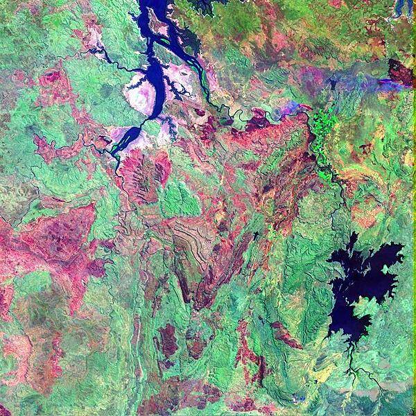
False-color satellite image shows a portion of the Kimberley Plateau, situated north of the Great Sandy Desert in a remote stretch of the province of Western Australia. In this scene, the Durack, Chamberlain, and Ord Rivers wind their way northward to the Joseph Bonaparte Gulf. The long elongated water bodies in the north are backwaters from the Timor Sea. The reddish brown patches are fire scars in the otherwise densely-vegetated (green) area. During the summer months, lightning strikes can quickly spark dozens of wildfires across Australia's Western and Northern Territories, giving the landscape its mottled appearance. Image courtesy of NASA.
False-color satellite image shows a portion of the Kimberley Plateau, situated north of the Great Sandy Desert in a remote stretch of the province of Western Australia. In this scene, the Durack, Chamberlain, and Ord Rivers wind their way northward to the Joseph Bonaparte Gulf. The long elongated water bodies in the north are backwaters from the Timor Sea. The reddish brown patches are fire scars in the otherwise densely-vegetated (green) area. During the summer months, lightning strikes can quickly spark dozens of wildfires across Australia's Western and Northern Territories, giving the landscape its mottled appearance. Image courtesy of NASA. • CIA World Factbook • 2020
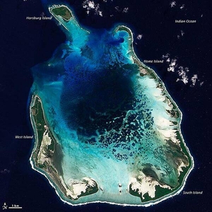
The Cocos (Keeling) Islands lie in the eastern Indian Ocean, about 2,900 km (1,800 mi) northwest of the Australian city of Perth. Comprised of coral atolls and islands, the archipelago includes North Keeling Island and the South Keeling Islands. This natural-color satellite image of the South Keeling Islands dates to 31 July 2009. Coral atolls - which are largely composed of huge colonies of tiny animals - form atop islands. Over time the islands may subside, but the coral remains growing upward and generally forming complete or partial rings. Only some parts of the South Keeling Islands still stand above the water surface. In the north, the ocean overtops the coral. Along the southern rim of this coral atoll, the shallow water appears aquamarine. The water darkens to navy blue as it deepens toward the central lagoon. Above the water line, coconut palms and other plants form a thick carpet of vegetation. In 2005, the Australian Government issued a report on the Cocos (Keeling) Islands, summarizing field research conducted between 1997 and 2005. Overall, the report noted, "the coral reef community at Cocos (Keeling) Islands is very healthy and in a stable period, with little impact from anthropogenic activities." Image courtesy of NASA.
The Cocos (Keeling) Islands lie in the eastern Indian Ocean, about 2,900 km (1,800 mi) northwest of the Australian city of Perth. Comprised of coral atolls and islands, the archipelago includes North Keeling Island and the South Keeling Islands. This natural-color satellite image of the South Keeling Islands dates to 31 July 2009.
Coral atolls - which are largely composed of huge colonies of tiny animals - form atop islands. Over time the islands may subside, but the coral remains growing upward and generally forming complete or partial rings. Only some parts of the South Keeling Islands still stand above the water surface. In the north, the ocean overtops the coral.
Along the southern rim of this coral atoll, the shallow water appears aquamarine. The water darkens to navy blue as it deepens toward the central lagoon. Above the water line, coconut palms and other plants form a thick carpet of vegetation.
In 2005, the Australian Government issued a report on the Cocos (Keeling) Islands, summarizing field research conducted between 1997 and 2005. Overall, the report noted, "the coral reef community at Cocos (Keeling) Islands is very healthy and in a stable period, with little impact from anthropogenic activities." Image courtesy of NASA. • CIA World Factbook • 2020
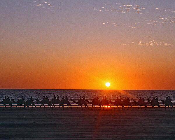
Camel caravan at sunset on Cable Beach, 7 km (4 mi) from Broome, Western Australia. Founded in 1883, Broome's first industry was pearling - carried out by Japanese divers. Today the pearling industry has given way to oyster harvesting, mining, and tourism.
Camel caravan at sunset on Cable Beach, 7 km (4 mi) from Broome, Western Australia. Founded in 1883, Broome's first industry was pearling - carried out by Japanese divers. Today the pearling industry has given way to oyster harvesting, mining, and tourism. • CIA World Factbook • 2020
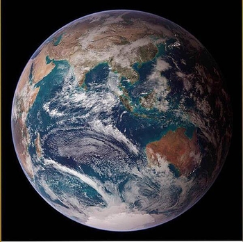
This "blue marble" image of the globe merges data from multiple satellite missions (not all collected at the same time). The focus in this view is the Indian Ocean and its surrounding land masses. Notice the city lights on the night side of the globe, in Japan in the north and in eastern Australia in the south. Image courtesy of NASA.
This "blue marble" image of the globe merges data from multiple satellite missions (not all collected at the same time). The focus in this view is the Indian Ocean and its surrounding land masses. Notice the city lights on the night side of the globe, in Japan in the north and in eastern Australia in the south. Image courtesy of NASA. • CIA World Factbook • 2020
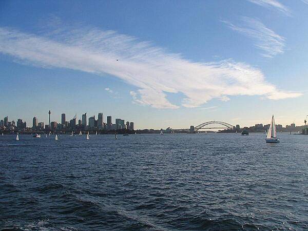
View of Sydney's Harbor and skyline from a boat.
View of Sydney's Harbor and skyline from a boat. • CIA World Factbook • 2020
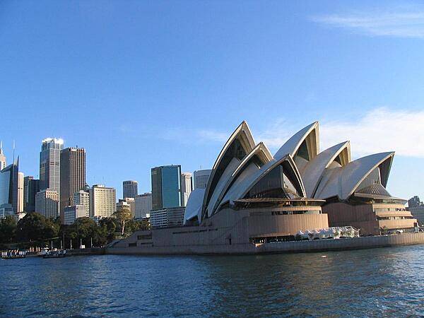
Sydney's Opera House is an iconic symbol of the city.
Sydney's Opera House is an iconic symbol of the city. • CIA World Factbook • 2020
87 photos available
View All Photos→Data sources: World Bank, UN Data • Updated daily •Learn about our data