›››
Australia — Media Gallery
87 items available (flags, maps, photos)
Photos
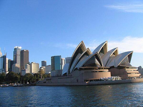
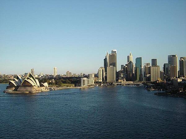
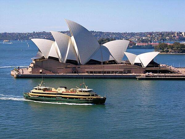
Sydney's Opera House is an iconic symbol of the city.
Sydney's Opera House is an iconic symbol of the city. • CIA World Factbook • 2020
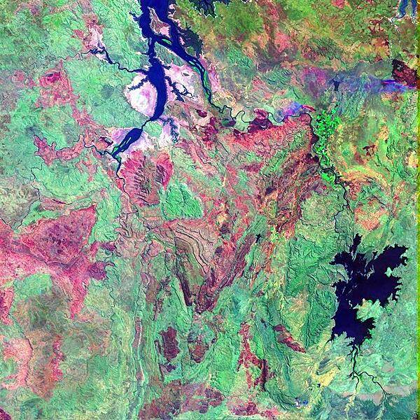
False-color satellite image shows a portion of the Kimberley Plateau, situated north of the Great Sandy Desert in a remote stretch of the province of Western Australia. In this scene, the Durack, Chamberlain, and Ord Rivers wind their way northward to the Joseph Bonaparte Gulf. The long elongated water bodies in the north are backwaters from the Timor Sea. The reddish brown patches are fire scars in the otherwise densely-vegetated (green) area. During the summer months, lightning strikes can quickly spark dozens of wildfires across Australia's Western and Northern Territories, giving the landscape its mottled appearance. Image courtesy of NASA.
False-color satellite image shows a portion of the Kimberley Plateau, situated north of the Great Sandy Desert in a remote stretch of the province of Western Australia. In this scene, the Durack, Chamberlain, and Ord Rivers wind their way northward to the Joseph Bonaparte Gulf. The long elongated water bodies in the north are backwaters from the Timor Sea. The reddish brown patches are fire scars in the otherwise densely-vegetated (green) area. During the summer months, lightning strikes can quickly spark dozens of wildfires across Australia's Western and Northern Territories, giving the landscape its mottled appearance. Image courtesy of NASA. • CIA World Factbook • 2020
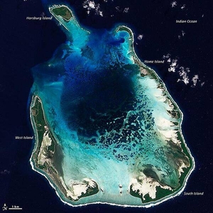
The Cocos (Keeling) Islands lie in the eastern Indian Ocean, about 2,900 km (1,800 mi) northwest of the Australian city of Perth. Comprised of coral atolls and islands, the archipelago includes North Keeling Island and the South Keeling Islands. This natural-color satellite image of the South Keeling Islands dates to 31 July 2009. Coral atolls - which are largely composed of huge colonies of tiny animals - form atop islands. Over time the islands may subside, but the coral remains growing upward and generally forming complete or partial rings. Only some parts of the South Keeling Islands still stand above the water surface. In the north, the ocean overtops the coral. Along the southern rim of this coral atoll, the shallow water appears aquamarine. The water darkens to navy blue as it deepens toward the central lagoon. Above the water line, coconut palms and other plants form a thick carpet of vegetation. In 2005, the Australian Government issued a report on the Cocos (Keeling) Islands, summarizing field research conducted between 1997 and 2005. Overall, the report noted, "the coral reef community at Cocos (Keeling) Islands is very healthy and in a stable period, with little impact from anthropogenic activities." Image courtesy of NASA.
The Cocos (Keeling) Islands lie in the eastern Indian Ocean, about 2,900 km (1,800 mi) northwest of the Australian city of Perth. Comprised of coral atolls and islands, the archipelago includes North Keeling Island and the South Keeling Islands. This natural-color satellite image of the South Keeling Islands dates to 31 July 2009.
Coral atolls - which are largely composed of huge colonies of tiny animals - form atop islands. Over time the islands may subside, but the coral remains growing upward and generally forming complete or partial rings. Only some parts of the South Keeling Islands still stand above the water surface. In the north, the ocean overtops the coral.
Along the southern rim of this coral atoll, the shallow water appears aquamarine. The water darkens to navy blue as it deepens toward the central lagoon. Above the water line, coconut palms and other plants form a thick carpet of vegetation.
In 2005, the Australian Government issued a report on the Cocos (Keeling) Islands, summarizing field research conducted between 1997 and 2005. Overall, the report noted, "the coral reef community at Cocos (Keeling) Islands is very healthy and in a stable period, with little impact from anthropogenic activities." Image courtesy of NASA. • CIA World Factbook • 2020
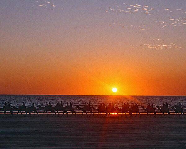
Camel caravan at sunset on Cable Beach, 7 km (4 mi) from Broome, Western Australia. Founded in 1883, Broome's first industry was pearling - carried out by Japanese divers. Today the pearling industry has given way to oyster harvesting, mining, and tourism.
Camel caravan at sunset on Cable Beach, 7 km (4 mi) from Broome, Western Australia. Founded in 1883, Broome's first industry was pearling - carried out by Japanese divers. Today the pearling industry has given way to oyster harvesting, mining, and tourism. • CIA World Factbook • 2020
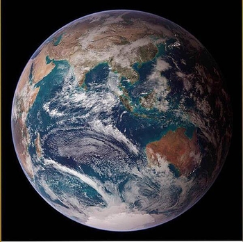
This "blue marble" image of the globe merges data from multiple satellite missions (not all collected at the same time). The focus in this view is the Indian Ocean and its surrounding land masses. Notice the city lights on the night side of the globe, in Japan in the north and in eastern Australia in the south. Image courtesy of NASA.
This "blue marble" image of the globe merges data from multiple satellite missions (not all collected at the same time). The focus in this view is the Indian Ocean and its surrounding land masses. Notice the city lights on the night side of the globe, in Japan in the north and in eastern Australia in the south. Image courtesy of NASA. • CIA World Factbook • 2020
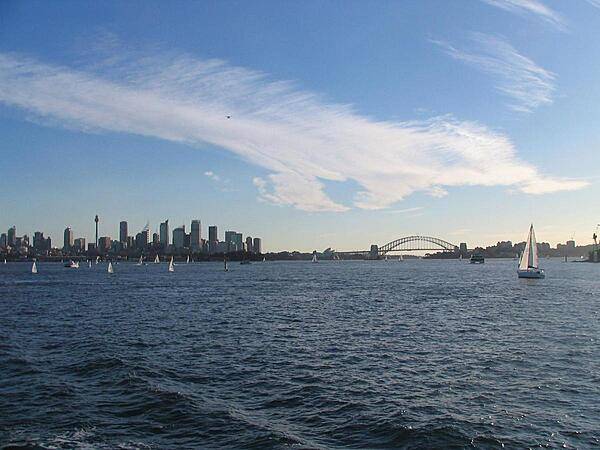
View of Sydney's Harbor and skyline from a boat.
View of Sydney's Harbor and skyline from a boat. • CIA World Factbook • 2020
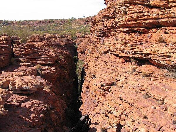
A view in Kings Canyon, a natural wonder in Australia's Outback.
A view in Kings Canyon, a natural wonder in Australia's Outback. • CIA World Factbook • 2020

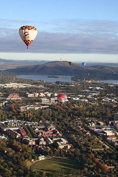
Canberra from the air. This view of Australia's capital includes the Parliament Building, Lake Burley Griffin, and the Black Mountain (telecommunications) Tower.
Canberra from the air. This view of Australia's capital includes the Parliament Building, Lake Burley Griffin, and the Black Mountain (telecommunications) Tower. • CIA World Factbook • 2020
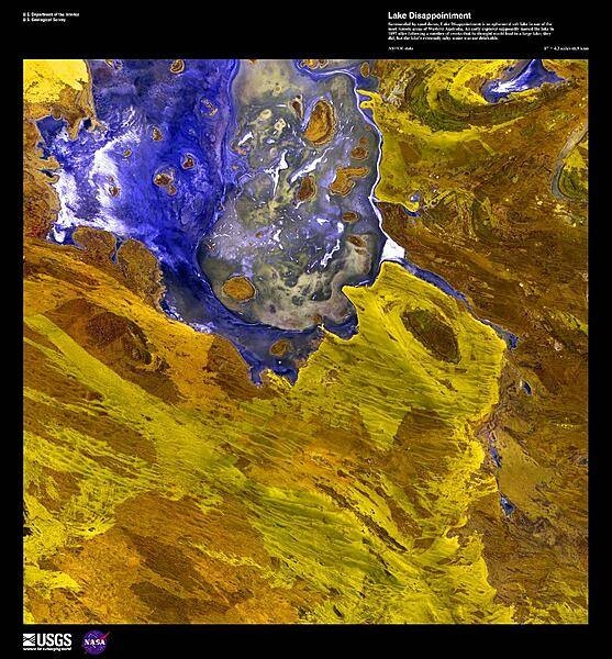
A false-color satellite image of Lake Disappointment, an ephemeral salt lake surrounded by sand dunes in one of the most remote areas of Western Australia. An early explorer supposedly named the lake in 1897 after following a number of creeks that he thought would lead to a large lake; they did, but the lake's extremely salty water was not drinkable. Image courtesy of USGS.
A false-color satellite image of Lake Disappointment, an ephemeral salt lake surrounded by sand dunes in one of the most remote areas of Western Australia. An early explorer supposedly named the lake in 1897 after following a number of creeks that he thought would lead to a large lake; they did, but the lake's extremely salty water was not drinkable. Image courtesy of USGS. • CIA World Factbook • 2020

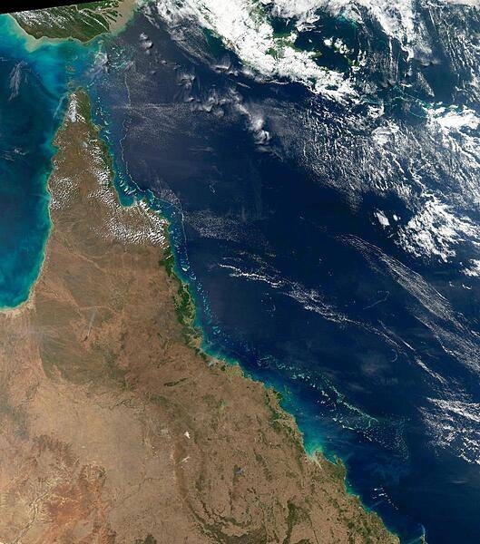
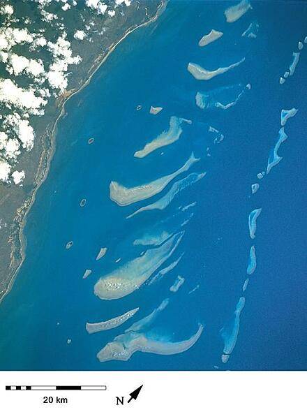
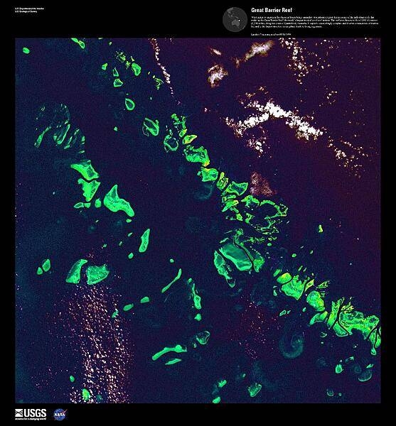
This view of northeast Australia taken by the Aqua satellite vividly shows the many offshore reefs that together form the Great Barrier Reef. The Reef stretches more than 2,000 km (1,240 mi) along the coast of Queensland and is a UNESCO World Heritage Site. Between the reefs and the coastline bands of brown-green "streamers" may be discerned. These are blue-green bacteria (cyanobacteria) that form long overlapping strands and films that can cover immense areas becoming visible even from space. Sailors have long called these brown streamers "sea sawdust." Image courtesy of NASA.
This view of northeast Australia taken by the Aqua satellite vividly shows the many offshore reefs that together form the Great Barrier Reef. The Reef stretches more than 2,000 km (1,240 mi) along the coast of Queensland and is a UNESCO World Heritage Site. Between the reefs and the coastline bands of brown-green "streamers" may be discerned. These are blue-green bacteria (cyanobacteria) that form long overlapping strands and films that can cover immense areas becoming visible even from space. Sailors have long called these brown streamers "sea sawdust." Image courtesy of NASA. • CIA World Factbook • 2020

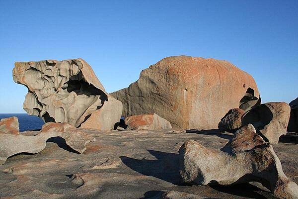
Admiral's Arch, a natural archway on Kangaroo Island, South Australia, was sculpted by weathering and erosion over thousands of years.
Admiral's Arch, a natural archway on Kangaroo Island, South Australia, was sculpted by weathering and erosion over thousands of years. • CIA World Factbook • 2020
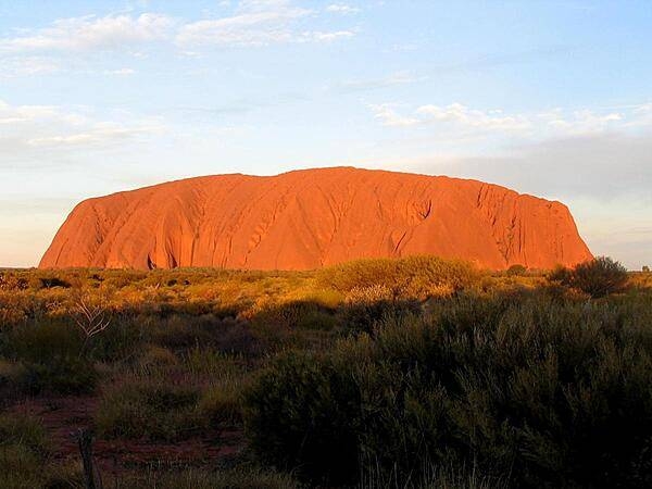
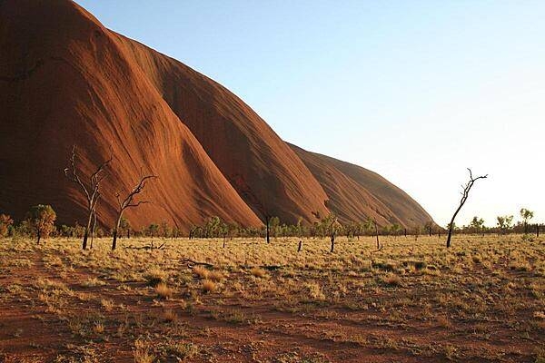
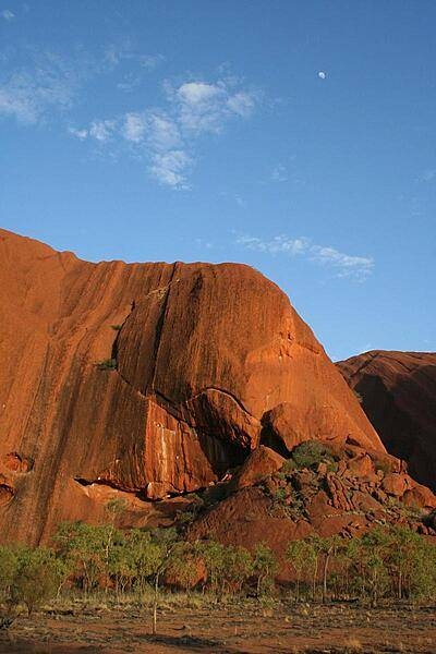
Uluru / Ayers Rock is an inselberg, or island mountain, found in the Northern Territory near Alice Springs - in the middle of Australia's Outback. It is a large sandstone rock formation that the aborigines of the area hold sacred.
Uluru / Ayers Rock is an inselberg, or island mountain, found in the Northern Territory near Alice Springs - in the middle of Australia's Outback. It is a large sandstone rock formation that the aborigines of the area hold sacred. • CIA World Factbook • 2020
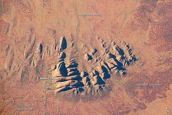
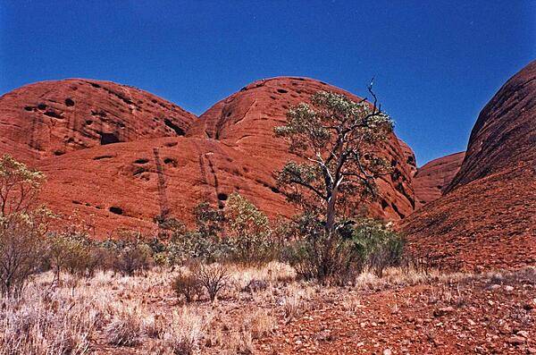
Located in the Northern Territory of Australia, Uluru-Kata Tjuta National Park hosts some of the world's most spectacular examples of inselbergs, or isolated mountains. The most famous of these inselbergs is Uluru (also known as Ayers Rock). An equally massive inselberg located approximately 30 km (20 mi) to the northwest is known as Kata Tjuta. Like Uluru, this is a sacred site to the native Anangu or Aboriginal people. An English-born explorer named the highest peak Mount Olga, with the entire grouping of rocks informally known as "the Olgas." Mount Olga has a peak elevation of 1,069 m (3,507 ft) above sea level, making it 206 m (676 ft) higher than Uluru. In this astronaut photograph, afternoon sunlight highlights the rounded summits of Kata Tjuta against the surrounding sandy plains. Sand dunes are visible in the lower left, while in other areas (bottom and right) sediments washed from the rocks have been anchored by a variety of grasses and bushes adapted to the arid climate. Green vegetation in the ephemeral stream channels that drain Kata Tjuta (top center) provides colorful contrast with the red rocks and surrounding soils. Large gaps in the rocks (highlighted by shadows) are thought to be fractures that have been enlarged due to erosion. Image courtesy of NASA.
Located in the Northern Territory of Australia, Uluru-Kata Tjuta National Park hosts some of the world's most spectacular examples of inselbergs, or isolated mountains. The most famous of these inselbergs is Uluru (also known as Ayers Rock). An equally massive inselberg located approximately 30 km (20 mi) to the northwest is known as Kata Tjuta. Like Uluru, this is a sacred site to the native Anangu or Aboriginal people. An English-born explorer named the highest peak Mount Olga, with the entire grouping of rocks informally known as "the Olgas." Mount Olga has a peak elevation of 1,069 m (3,507 ft) above sea level, making it 206 m (676 ft) higher than Uluru.
In this astronaut photograph, afternoon sunlight highlights the rounded summits of Kata Tjuta against the surrounding sandy plains. Sand dunes are visible in the lower left, while in other areas (bottom and right) sediments washed from the rocks have been anchored by a variety of grasses and bushes adapted to the arid climate. Green vegetation in the ephemeral stream channels that drain Kata Tjuta (top center) provides colorful contrast with the red rocks and surrounding soils. Large gaps in the rocks (highlighted by shadows) are thought to be fractures that have been enlarged due to erosion. Image courtesy of NASA. • CIA World Factbook • 2020
Over the Kimberley Region of northern Western Australia, satellite sensors and airplane passengers alike can see a giant arachnid sprawling over the arid landscape. This spider is not just big, it is old. This prehistoric monster crawls out of the past as if to remind us of the destructive power of the cosmos. In this false-color satellite image Spider Crater and the surrounding arid landscape appear in varying shades of crimson. Water appears blue-black, namely in the meandering river near the bottom edge of the image. Vegetation appears in shades of red. While vegetation looks sparse throughout the area, the intense red dots along the river indicate fairly lush - if intermittent - vegetation lining the riverbanks. Strongly deformed layers of sedimentary rock give evidence of that the structure was formed by extraterrestrial trauma. Spider Crater rests in a depression some 13 by 11 km (8 by 7 mi) across. Meteorite craters often have central areas of uplift, and Spider Crater fits this pattern, with a central dome roughly 500 m (1,640 ft) in diameter. Radiating from this central dome are features unusual in impact craters in general, but important in giving this crater its nickname. Overlapping beds of tough sandstone that have weathered the elements far better than the surrounding rocks form the spider's "legs." So while Spider Crater sits in a depression and has a central uplift area characteristic of impact craters, it shows extreme differences in erosion, giving it a unique appearance. The age of Spider Crater is uncertain, but its formation has been estimated to fall between 900 and 600 million years ago. Image courtesy of NASA.
Over the Kimberley Region of northern Western Australia, satellite sensors and airplane passengers alike can see a giant arachnid sprawling over the arid landscape. This spider is not just big, it is old. This prehistoric monster crawls out of the past as if to remind us of the destructive power of the cosmos. In this false-color satellite image Spider Crater and the surrounding arid landscape appear in varying shades of crimson. Water appears blue-black, namely in the meandering river near the bottom edge of the image. Vegetation appears in shades of red. While vegetation looks sparse throughout the area, the intense red dots along the river indicate fairly lush - if intermittent - vegetation lining the riverbanks.
Strongly deformed layers of sedimentary rock give evidence of that the structure was formed by extraterrestrial trauma. Spider Crater rests in a depression some 13 by 11 km (8 by 7 mi) across. Meteorite craters often have central areas of uplift, and Spider Crater fits this pattern, with a central dome roughly 500 m (1,640 ft) in diameter. Radiating from this central dome are features unusual in impact craters in general, but important in giving this crater its nickname. Overlapping beds of tough sandstone that have weathered the elements far better than the surrounding rocks form the spider's "legs." So while Spider Crater sits in a depression and has a central uplift area characteristic of impact craters, it shows extreme differences in erosion, giving it a unique appearance. The age of Spider Crater is uncertain, but its formation has been estimated to fall between 900 and 600 million years ago. Image courtesy of NASA. • CIA World Factbook • 2020
A green sentinal overlooking Kings Canyon in Australia's Outback.
A green sentinal overlooking Kings Canyon in Australia's Outback. • CIA World Factbook • 2020
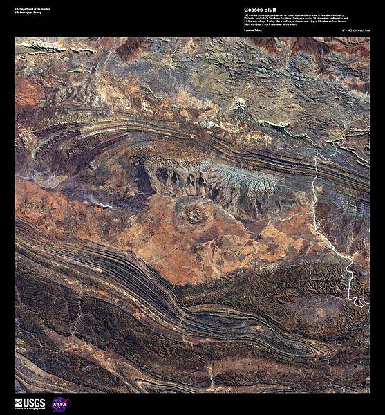
142 million years ago, an asteroid or comet slammed into what is now the Missionary Plains in the Northern Territory, forming a crater 24 km (15 mi) in diameter. Due to erosion, the crater rim has been reduced to only 5 km (3 mi). Today, like a bull's eye, the circular ring of hills that defines Gosses Bluff (image center) stands as a stark reminder of the event shown in this high-resolution satellite photo. Image courtesy of USGS.
142 million years ago, an asteroid or comet slammed into what is now the Missionary Plains in the Northern Territory, forming a crater 24 km (15 mi) in diameter. Due to erosion, the crater rim has been reduced to only 5 km (3 mi). Today, like a bull's eye, the circular ring of hills that defines Gosses Bluff (image center) stands as a stark reminder of the event shown in this high-resolution satellite photo. Image courtesy of USGS. • CIA World Factbook • 2020
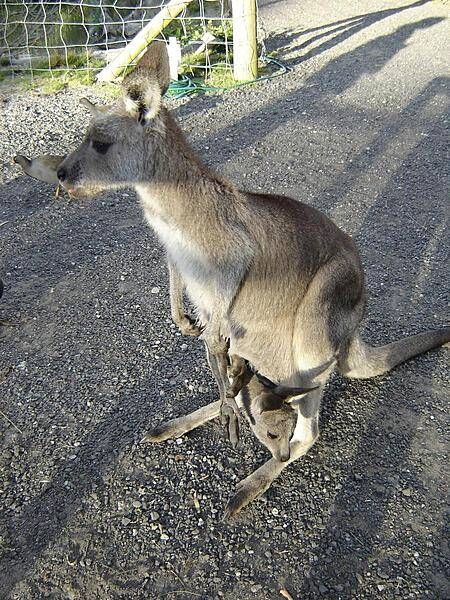
Often mistaken for kangaroos, wallabies abound in Australia; this one has a baby (joey) in its pouch.
Often mistaken for kangaroos, wallabies abound in Australia; this one has a baby (joey) in its pouch. • CIA World Factbook • 2020
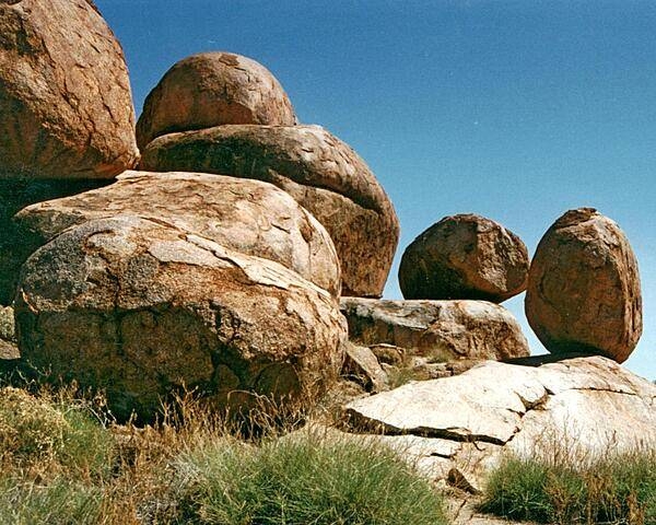
Some of the granite boulders at Devils Marbles Conservation Reserve near Wauchope, in the Northern Territory. The marbles were formed through various geological processes including chemical and mechanical weathering.
Some of the granite boulders at Devils Marbles Conservation Reserve near Wauchope, in the Northern Territory. The marbles were formed through various geological processes including chemical and mechanical weathering. • CIA World Factbook • 2020
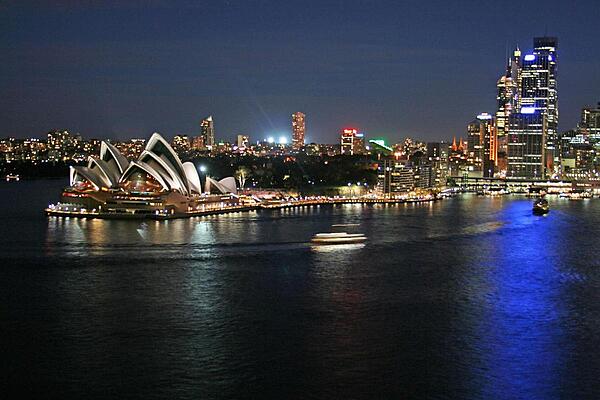
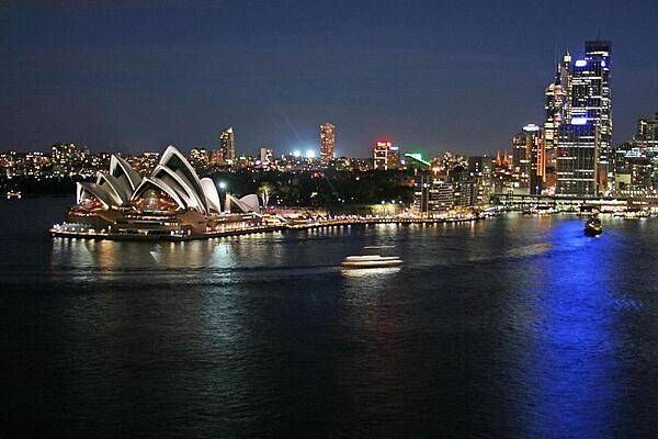
Night at Circular Quay in Sydney. View includes the Central Business District, Circular Quay, and the Sydney Opera House.
Night at Circular Quay in Sydney. View includes the Central Business District, Circular Quay, and the Sydney Opera House. • CIA World Factbook • 2020
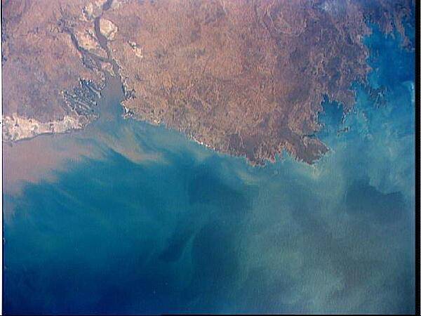
A view of the northern coast of Western Australia shows the low lying coastal plains that surround much of Joseph Bonaparte Gulf, Western Australia. Large plumes of sediment have been washed into the Cambridge Gulf, probably from the Victoria River, which flows into the Gulf just outside the area of the photo. Image courtesy of NASA.
A view of the northern coast of Western Australia shows the low lying coastal plains that surround much of Joseph Bonaparte Gulf, Western Australia. Large plumes of sediment have been washed into the Cambridge Gulf, probably from the Victoria River, which flows into the Gulf just outside the area of the photo. Image courtesy of NASA. • CIA World Factbook • 2020
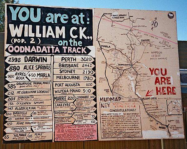
Wonderfully original sign in the Outback.
Wonderfully original sign in the Outback. • CIA World Factbook • 2020
CIA World Factbook • 2020
CIA World Factbook • 2020
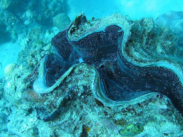
Encrusted giant clam in the Great Barrier Reef.
Encrusted giant clam in the Great Barrier Reef. • CIA World Factbook • 2020
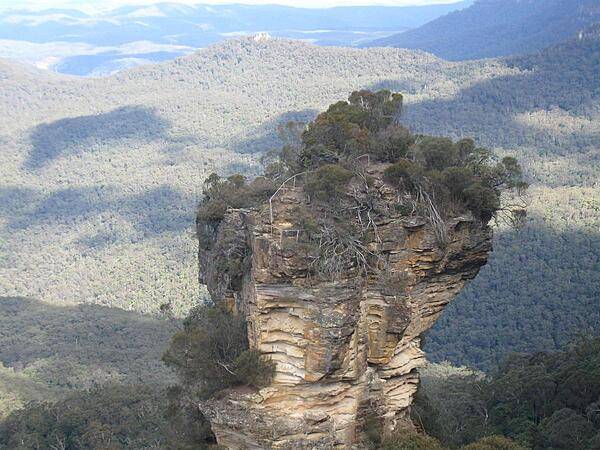
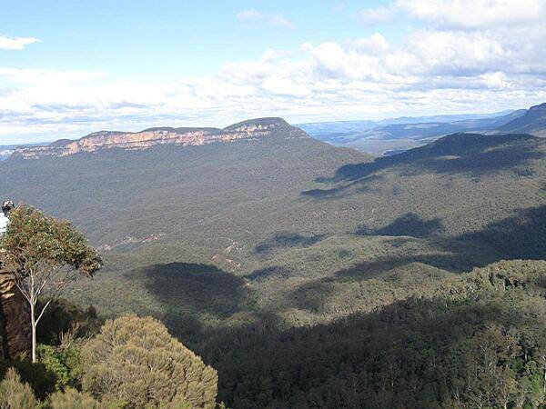
Orphan Rock in the Blue Mountains as viewed from a cable car.
Orphan Rock in the Blue Mountains as viewed from a cable car. • CIA World Factbook • 2020
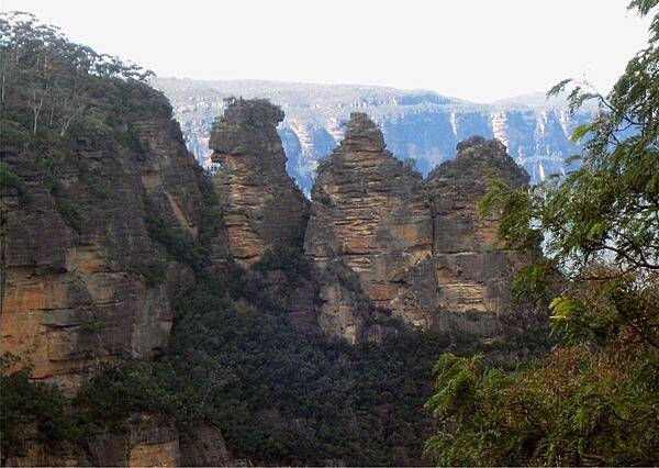
A close up of the Three Sisters sandstone rock formation in the Blue Mountains.
A close up of the Three Sisters sandstone rock formation in the Blue Mountains. • CIA World Factbook • 2020
CIA World Factbook • 2020
Another view of the Bomana War Cemetery near Port Moresby. The cemetery contains the graves of over 3,800 Allied service members - Australian and Papuan - who successfully fought to prevent the Japanese Empire from taking Papua New Guinea in World War II. Photo courtesy of the US Marine Corps/ Cpl. William Hester.
Another view of the Bomana War Cemetery near Port Moresby. The cemetery contains the graves of over 3,800 Allied service members - Australian and Papuan - who successfully fought to prevent the Japanese Empire from taking Papua New Guinea in World War II. Photo courtesy of the US Marine Corps/ Cpl. William Hester. • CIA World Factbook • 2020
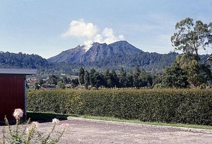
Indonesia is tectonically highly unstable, making it the site of numerous volcanoes and frequent earthquakes. The archipelago lies on the Pacific Ring of Fire where the Indo-Australian Plate and the Pacific Plate are pushed under the Eurasian plate and where they melt at about 100 km (62 mi) below the earths' surface. A string of volcanoes runs southeastward through Sumatra, Java, Bali, and Nusa Tenggara, and then fishhooks north and westward to the Banda Islands of Maluku and North Sulawesi. Indonesia has about 150 active volcanoes, the most of any country on earth. The photo shows a dormant but smoking volcano on the island of Sumatra.
Indonesia is tectonically highly unstable, making it the site of numerous volcanoes and frequent earthquakes. The archipelago lies on the Pacific Ring of Fire where the Indo-Australian Plate and the Pacific Plate are pushed under the Eurasian plate and where they melt at about 100 km (62 mi) below the earths' surface. A string of volcanoes runs southeastward through Sumatra, Java, Bali, and Nusa Tenggara, and then fishhooks north and westward to the Banda Islands of Maluku and North Sulawesi. Indonesia has about 150 active volcanoes, the most of any country on earth. The photo shows a dormant but smoking volcano on the island of Sumatra. • CIA World Factbook • 2020
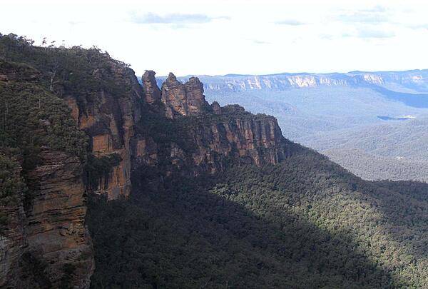
The Three Sisters sandstone rock formation in the Blue Mountains west of Sydney.
The Three Sisters sandstone rock formation in the Blue Mountains west of Sydney. • CIA World Factbook • 2020
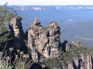
The Blue Mountains are outside of Sydney; this formation is known as the Three Sisters.
The Blue Mountains are outside of Sydney; this formation is known as the Three Sisters. • CIA World Factbook • 2020
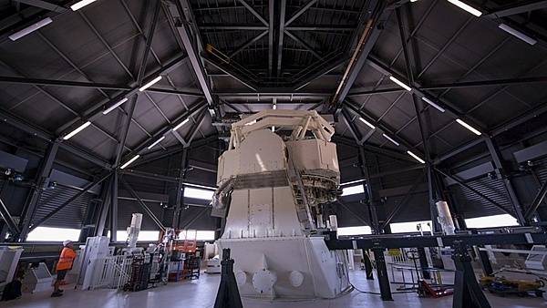
The Space Surveillance Telescope (SST), located near Exmouth, in Western Australia is operated by the US Air Force in conjunction with the Royal Australian Air Force. The SST is a ground-based optical system that detects and tracks small objects in deep space, and provides an unprecedented wide-area search capability that will enhance space situational awareness of the Southern Celestial Hemisphere. Minimal light pollution will allow the telescope to provide a clearer picture that lends to its wide field of view. With an estimated time of full operational capability in 2021, it will also be able to detect, track, and discern small, obscure objects in deep space. Photo courtesy of the US Navy/ Mass Communication Specialist 2nd Class Jeanette Mullinax.
The Space Surveillance Telescope (SST), located near Exmouth, in Western Australia is operated by the US Air Force in conjunction with the Royal Australian Air Force. The SST is a ground-based optical system that detects and tracks small objects in deep space, and provides an unprecedented wide-area search capability that will enhance space situational awareness of the Southern Celestial Hemisphere. Minimal light pollution will allow the telescope to provide a clearer picture that lends to its wide field of view. With an estimated time of full operational capability in 2021, it will also be able to detect, track, and discern small, obscure objects in deep space. Photo courtesy of the US Navy/ Mass Communication Specialist 2nd Class Jeanette Mullinax. • CIA World Factbook • 2020
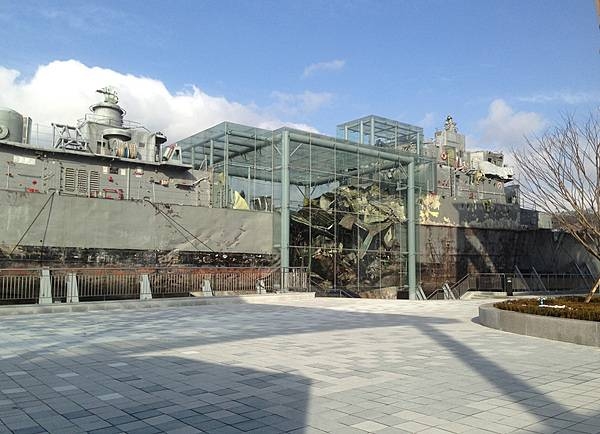
The salvaged remains of the Republic of Korea Navy ship Cheonan on display in a memorial museum in Pyeongtaek. The vessel sank on 26 March 2010 off the country's west coast near Baengnyeong Island in the Yellow Sea, killing 46 of 104 seamen. The cause of the sinking remains in dispute, but an investigation carried out by a team of international experts from South Korea, the US, the UK, Canada, Australia, and Sweden concluded on 20 May 2010 that the warship had been sunk by a North Korean torpedo fired by a midget submarine.
The salvaged remains of the Republic of Korea Navy ship Cheonan on display in a memorial museum in Pyeongtaek. The vessel sank on 26 March 2010 off the country's west coast near Baengnyeong Island in the Yellow Sea, killing 46 of 104 seamen. The cause of the sinking remains in dispute, but an investigation carried out by a team of international experts from South Korea, the US, the UK, Canada, Australia, and Sweden concluded on 20 May 2010 that the warship had been sunk by a North Korean torpedo fired by a midget submarine. • CIA World Factbook • 2020
A view of the famous Kokoda Track that crosses the Owen Stanley Mountains of Papua New Guinea from Port Moresby in the west to Buna on the east coast. In 1942, Imperial Japanese forces invaded New Guinea, then a territory of Australia, in a bid to capture Port Moresby. In a bitterly contested campaign fought along the Kokoda Track from July to November 1942, the Australian Army turned back the invasion and eventually forced the Japanese back to their starting point. Ammunition and supplies were trucked 45 km (28 mi) from Port Moresby to Owers Corner where they were repacked in Uberi, a major supply base just beyond the Goldie River. From Uberi supplies had to be hand-carried along the tortuous track ahead. Native Papuans provided invaluable assistance in carrying supplies forward and evacuating casualties to the rear area hospitals. Photo courtesy of the US Marine Corps/ Lance Cpl. Jesus McCloud.
A view of the famous Kokoda Track that crosses the Owen Stanley Mountains of Papua New Guinea from Port Moresby in the west to Buna on the east coast. In 1942, Imperial Japanese forces invaded New Guinea, then a territory of Australia, in a bid to capture Port Moresby. In a bitterly contested campaign fought along the Kokoda Track from July to November 1942, the Australian Army turned back the invasion and eventually forced the Japanese back to their starting point. Ammunition and supplies were trucked 45 km (28 mi) from Port Moresby to Owers Corner where they were repacked in Uberi, a major supply base just beyond the Goldie River. From Uberi supplies had to be hand-carried along the tortuous track ahead. Native Papuans provided invaluable assistance in carrying supplies forward and evacuating casualties to the rear area hospitals. Photo courtesy of the US Marine Corps/ Lance Cpl. Jesus McCloud. • CIA World Factbook • 2020
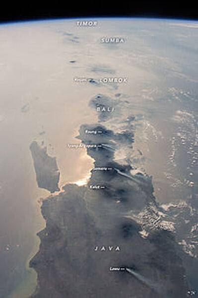
This photograph, taken from the International Space Station in 2015, looks eastward: Java is in the foreground, Bali and Lombok are near the center, and smaller islands trail off toward the horizon. The brightest reflection of the Sun off the sea surface silhouettes Surabaya, Indonesia’s second-largest city of almost 3 million. Against this background of glint as well as regional smoke, a line of volcanoes appears in sharp detail. Volcanoes are the backbone of the islands, which have been formed by the collision of the Australian tectonic plate (right) with the Asian plate (left). The name of each volcano appears in italics. White plumes - each about 80 km (50 mi) long - show that at least six volcanoes appeared to be emitting steam and smoke. The plumes are strikingly parallel, aligned with winds from the northeast. Image courtesy of NASA.
This photograph, taken from the International Space Station in 2015, looks eastward: Java is in the foreground, Bali and Lombok are near the center, and smaller islands trail off toward the horizon. The brightest reflection of the Sun off the sea surface silhouettes Surabaya, Indonesia’s second-largest city of almost 3 million. Against this background of glint as well as regional smoke, a line of volcanoes appears in sharp detail. Volcanoes are the backbone of the islands, which have been formed by the collision of the Australian tectonic plate (right) with the Asian plate (left). The name of each volcano appears in italics. White plumes - each about 80 km (50 mi) long - show that at least six volcanoes appeared to be emitting steam and smoke. The plumes are strikingly parallel, aligned with winds from the northeast. Image courtesy of NASA. • CIA World Factbook • 2020
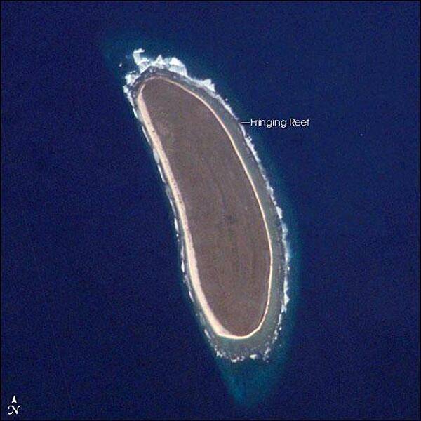
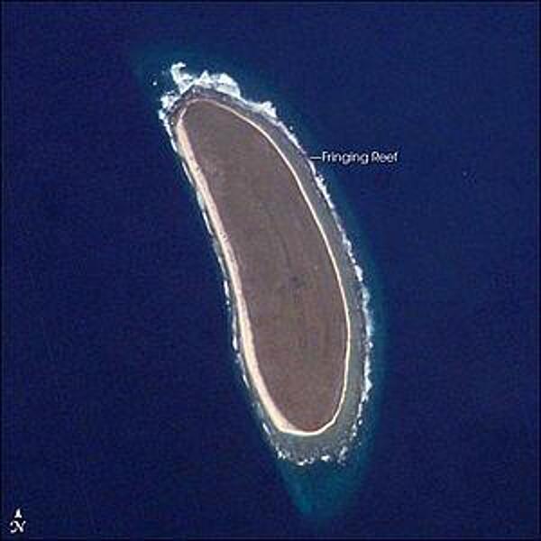
Howland Island is an uninhabited coral island located just north of the equator in the central Pacific Ocean, about 3,100 km southwest of Honolulu - almost halfway between Hawaii and Australia. The island is composed of coral fragments and is surrounded by an active fringing reef. White breakers encircling the island indicate the position of the reef. Image courtesy of NASA.
Howland Island is an uninhabited coral island located just north of the equator in the central Pacific Ocean, about 3,100 km southwest of Honolulu - almost halfway between Hawaii and Australia. The island is composed of coral fragments and is surrounded by an active fringing reef. White breakers encircling the island indicate the position of the reef. Image courtesy of NASA. • CIA World Factbook • 2020
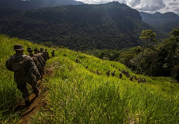
US Marines and soldiers from the Papua New Guinea Defence Force, hike the historical Kokoda trail during a military exercize in 2016. In 1942, Imperial Japanese forces invaded New Guinea, then a territory of Australia, in a bid to capture Port Moresby. In a bitterly contested campaign fought along the Kokoda Track from July to November 1942, the Australian Army turned back the invasion and eventually forced the Japanese back to their starting point. Ammunition and supplies were trucked 45 km (28 mi) from Port Moresby to Owers Corner where they were repacked in Uberi, a major supply base just beyond the Goldie River. From Uberi supplies had to be hand-carried along the tortuous track ahead. Native Papuans provided invaluable assistance in carrying supplies forward and evacuating casualties to rear area hospitals. Photo courtesy of the US Marine Corps/ Lance Cpl. Jesus McCloud.
US Marines and soldiers from the Papua New Guinea Defence Force, hike the historical Kokoda trail during a military exercize in 2016. In 1942, Imperial Japanese forces invaded New Guinea, then a territory of Australia, in a bid to capture Port Moresby. In a bitterly contested campaign fought along the Kokoda Track from July to November 1942, the Australian Army turned back the invasion and eventually forced the Japanese back to their starting point. Ammunition and supplies were trucked 45 km (28 mi) from Port Moresby to Owers Corner where they were repacked in Uberi, a major supply base just beyond the Goldie River. From Uberi supplies had to be hand-carried along the tortuous track ahead. Native Papuans provided invaluable assistance in carrying supplies forward and evacuating casualties to rear area hospitals. Photo courtesy of the US Marine Corps/ Lance Cpl. Jesus McCloud. • CIA World Factbook • 2020
CIA World Factbook • 2020

Visiting US Sailors join the crowd riding the Redback at Aussie World, a theme park located on the Sunshine Coast in Queensland, Australia. Photo courtesy of the US Navy/ Mass Communication Specialist 3rd Class Jessica Gomez.
Visiting US Sailors join the crowd riding the Redback at Aussie World, a theme park located on the Sunshine Coast in Queensland, Australia. Photo courtesy of the US Navy/ Mass Communication Specialist 3rd Class Jessica Gomez. • CIA World Factbook • 2020
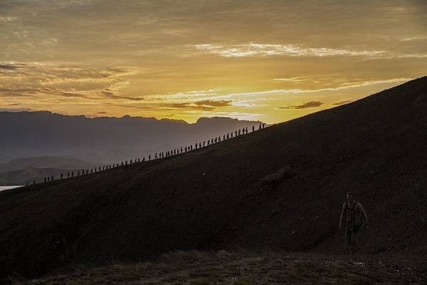
As part of a multinational training exercise, US Marines and US Sailors, Australian soldiers, and British soldiers hike a hill along the Kokoda Track in Papua New Guinea in 2015. The exercise was designed to provide assistance to Papua New Guinea through infrastructure rehabilitation and basic military training. Photo courtesy of the US Marine Corps/ Cpl. William Hester.
As part of a multinational training exercise, US Marines and US Sailors, Australian soldiers, and British soldiers hike a hill along the Kokoda Track in Papua New Guinea in 2015. The exercise was designed to provide assistance to Papua New Guinea through infrastructure rehabilitation and basic military training. Photo courtesy of the US Marine Corps/ Cpl. William Hester. • CIA World Factbook • 2020
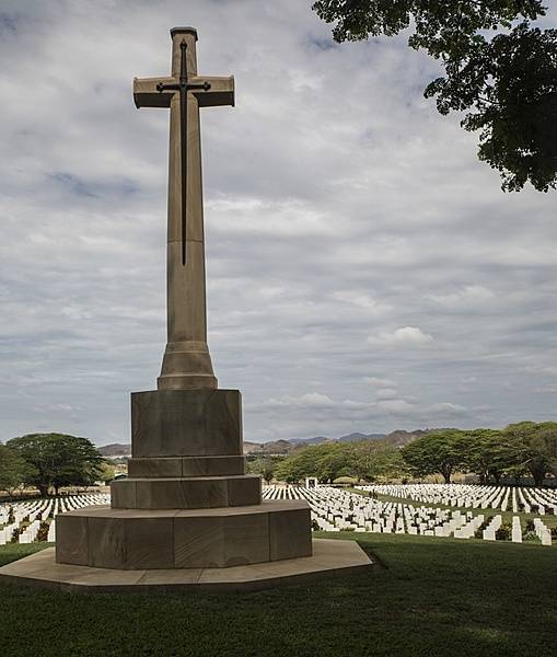
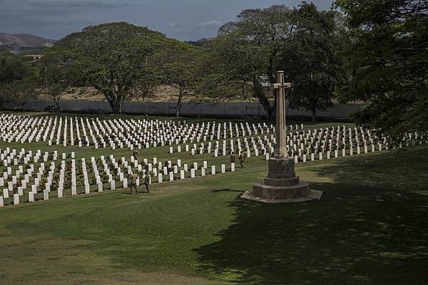
A view of the Cross of Sacrifice at the Bomana War Cemetery near Port Moresby. The cemetery is the final resting place of more than 3,800 Allied service members - Australian and Papuan - who successfully fought to prevent the Japanese Empire from taking Papua New Guinea in World War II. Photo courtesy of the US Marine Corps/ Cpl. William Hester.
A view of the Cross of Sacrifice at the Bomana War Cemetery near Port Moresby. The cemetery is the final resting place of more than 3,800 Allied service members - Australian and Papuan - who successfully fought to prevent the Japanese Empire from taking Papua New Guinea in World War II. Photo courtesy of the US Marine Corps/ Cpl. William Hester. • CIA World Factbook • 2020
Australia-US area comparison map
Australia-US area comparison map • CIA World Factbook • 2020
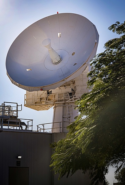
The US Air Force and the Royal Australian Air Force are working together near Exmouth, in Western Australia, to advance the combined Space Surveillance Network with a C-Band space surveillance radar system and a space surveillance telescope. A C-Band space surveillance radar system, owned by the US Air Force, operates as a dedicated sensor node strategically located to cover both the southern and eastern hemisphere. The C-Band radar provides tracking and identification of space assets and debris for the US space surveillance network. Photo courtesy of the US Navy/ Mass Communication Specialist 2nd Class Jeanette Mullinax.
The US Air Force and the Royal Australian Air Force are working together near Exmouth, in Western Australia, to advance the combined Space Surveillance Network with a C-Band space surveillance radar system and a space surveillance telescope. A C-Band space surveillance radar system, owned by the US Air Force, operates as a dedicated sensor node strategically located to cover both the southern and eastern hemisphere. The C-Band radar provides tracking and identification of space assets and debris for the US space surveillance network. Photo courtesy of the US Navy/ Mass Communication Specialist 2nd Class Jeanette Mullinax. • CIA World Factbook • 2020
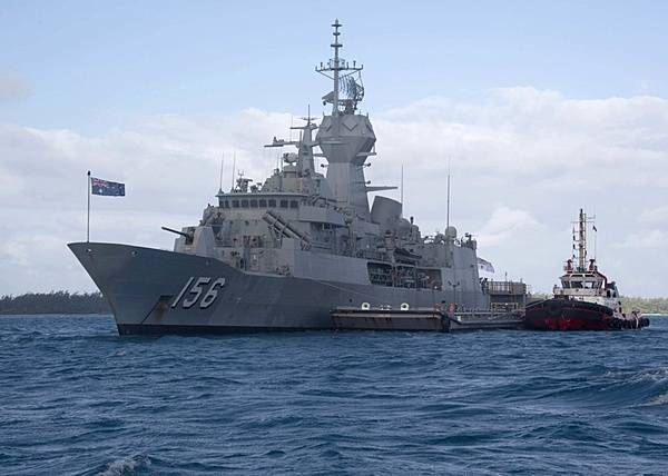
The Australian frigate HMAS Toowoomba makes a port call at Diego Garcia. The lagoon provides a sheltered anchorage for replenishment. Diego Garcia provides critical logistical infrastructure support to US and Allied Forces forward deployed to the Indian Ocean and Arabian Gulf. Photo courtesy of the US Navy.
The Australian frigate HMAS Toowoomba makes a port call at Diego Garcia. The lagoon provides a sheltered anchorage for replenishment. Diego Garcia provides critical logistical infrastructure support to US and Allied Forces forward deployed to the Indian Ocean and Arabian Gulf. Photo courtesy of the US Navy. • CIA World Factbook • 2020
This view of the Queensland coast of northeast Australia taken by the Aqua satellite vividly shows the many offshore reefs that together form the Great Barrier Reef. The various white specks in the deeper blue waters of the Coral Sea to the east are some of the reefs, cays, and islets that make up the Coral Sea Islands. Image courtesy of NASA.
This view of the Queensland coast of northeast Australia taken by the Aqua satellite vividly shows the many offshore reefs that together form the Great Barrier Reef. The various white specks in the deeper blue waters of the Coral Sea to the east are some of the reefs, cays, and islets that make up the Coral Sea Islands. Image courtesy of NASA. • CIA World Factbook • 2020
CIA World Factbook • 2020
CIA World Factbook • 2020
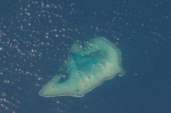
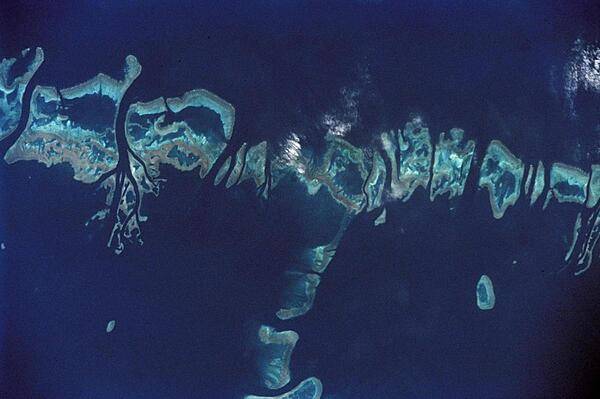
Ashmore Island (actually composed of three reef islets) is part of Ashmore Reef National Nature Reserve, which comprises several marine habitats, including seagrass meadows, intertidal sand flats, coral reef flats, and lagoons. This astronaut photo from 2011 shows that the reef making up the island is not continuous but has several breaks that allow for current and sediment inflow. A memorandum of understanding between the Australian and Indonesian Governments allows Indonesian fishermen access to their traditional fishing grounds within the region, subject to limits. Image courtesy of NASA.
Ashmore Island (actually composed of three reef islets) is part of Ashmore Reef National Nature Reserve, which comprises several marine habitats, including seagrass meadows, intertidal sand flats, coral reef flats, and lagoons.
This astronaut photo from 2011 shows that the reef making up the island is not continuous but has several breaks that allow for current and sediment inflow.
A memorandum of understanding between the Australian and Indonesian Governments allows Indonesian fishermen access to their traditional fishing grounds within the region, subject to limits. Image courtesy of NASA. • CIA World Factbook • 2020
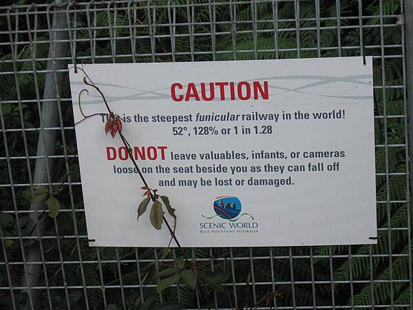
Warning sign posted at the Blue Mountains funicular railway.
Warning sign posted at the Blue Mountains funicular railway. • CIA World Factbook • 2020

CIA World Factbook • 2020
View of Cairns (in the Australian state of Queensland) from the air.
View of Cairns (in the Australian state of Queensland) from the air. • CIA World Factbook • 2020
Exterior view of Sydney Aquarium on the eastern side of Darling Harbour.
Exterior view of Sydney Aquarium on the eastern side of Darling Harbour. • CIA World Factbook • 2020
Howland Island is a US possession located in the north Pacific between Australia and the Hawaiian Islands. Prior to 1890, organic nitrate (guano) was mined from the island by both the US and the British. This tiny island (2.6 sq km) is currently part of the US National Wildlife Refuge system, and provides nesting areas and forage for a variety of birds and marine wildlife.
Howland Island is a US possession located in the north Pacific between Australia and the Hawaiian Islands. Prior to 1890, organic nitrate (guano) was mined from the island by both the US and the British. This tiny island (2.6 sq km) is currently part of the US National Wildlife Refuge system, and provides nesting areas and forage for a variety of birds and marine wildlife. • CIA World Factbook • 2020
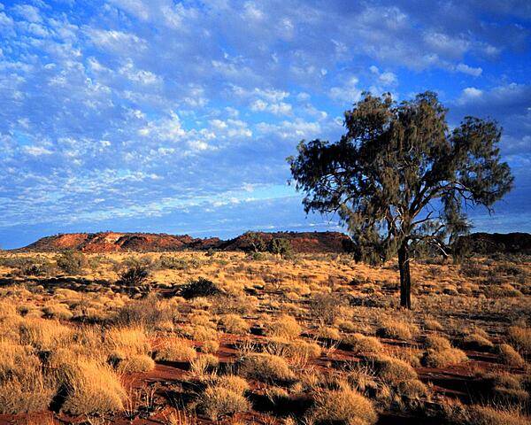
Incipient sunset in the Outback.
Incipient sunset in the Outback. • CIA World Factbook • 2020
CIA World Factbook • 2020
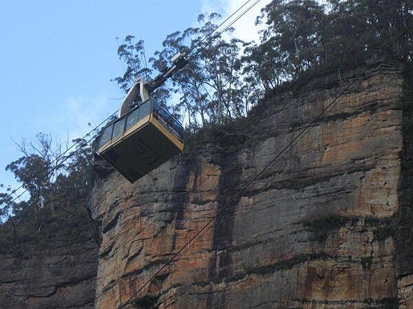
A view of the Blue Mountains as seen from a cable car.
A view of the Blue Mountains as seen from a cable car. • CIA World Factbook • 2020
A closer view of some of the northern reefs in the Great Barrier Reef where the continental shelf is relatively narrow and the reefs closer to shore. Image courtesy of NASA.
A closer view of some of the northern reefs in the Great Barrier Reef where the continental shelf is relatively narrow and the reefs closer to shore. Image courtesy of NASA. • CIA World Factbook • 2020
CIA World Factbook • 2020
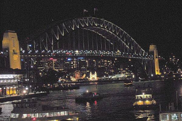
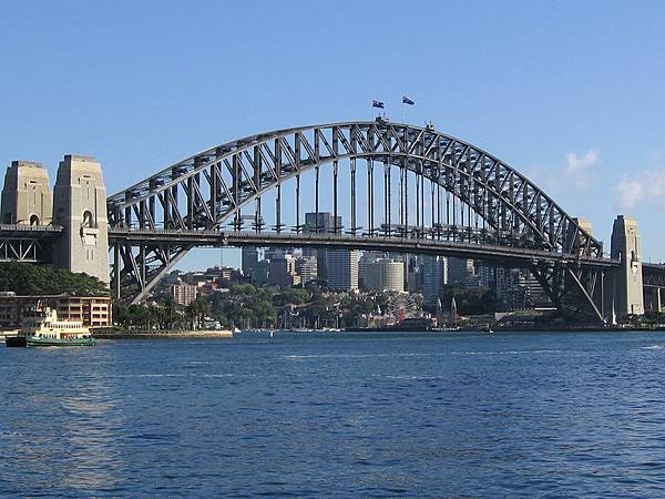
Night view of Sydney Harbor Bridge.
Night view of Sydney Harbor Bridge. • CIA World Factbook • 2020

The Sydney Tower is the tallest free-standing structure in the city and the second-tallest in Australia. The tower stands 309 m (1,014 ft) above the central business district.
The Sydney Tower is the tallest free-standing structure in the city and the second-tallest in Australia. The tower stands 309 m (1,014 ft) above the central business district. • CIA World Factbook • 2020
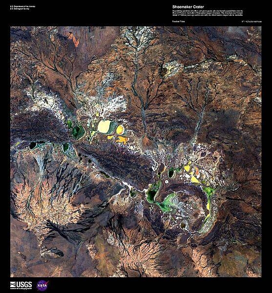
Resembling splotches of yellow and green paint, salt-encrusted seasonal lakes - the largest of which is Lake Teague - dot the floor of the Shoemaker impact crater in this enhanced satellite image. Formerly known as the Teague Ring, the structure was formed about 1.7 billion years ago and is currently the oldest known impact site in Australia. Image courtesy of USGS.
Resembling splotches of yellow and green paint, salt-encrusted seasonal lakes - the largest of which is Lake Teague - dot the floor of the Shoemaker impact crater in this enhanced satellite image. Formerly known as the Teague Ring, the structure was formed about 1.7 billion years ago and is currently the oldest known impact site in Australia. Image courtesy of USGS. • CIA World Factbook • 2020
CIA World Factbook • 2020
CIA World Factbook • 2020
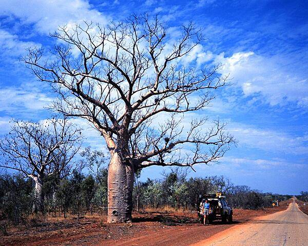
Boab trees along the Plenty Highway in the Outback. These trees store water in their swollen trunks and shed their leaves during the dry season. Indigenous Australians used them as a source of water and food, and utilized the leaves medicinally.
Boab trees along the Plenty Highway in the Outback. These trees store water in their swollen trunks and shed their leaves during the dry season. Indigenous Australians used them as a source of water and food, and utilized the leaves medicinally. • CIA World Factbook • 2020
CIA World Factbook • 2020
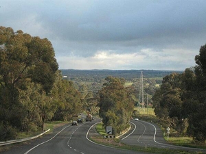
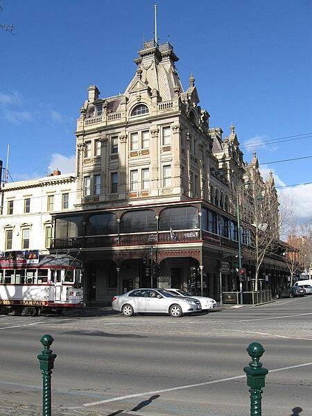
A view of the countryside in the state of Victoria - approaching Bendigo from Melbourne.
A view of the countryside in the state of Victoria - approaching Bendigo from Melbourne. • CIA World Factbook • 2020
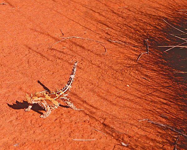
Although covered with an intimidating array of spikes, the thorny devil lizards that inhabit the scrub and desert of western Australia are actually quite gentle. Their main diet consists of ants. They can grow up to 20 cm (8 in) and can live up to 20 years.
Although covered with an intimidating array of spikes, the thorny devil lizards that inhabit the scrub and desert of western Australia are actually quite gentle. Their main diet consists of ants. They can grow up to 20 cm (8 in) and can live up to 20 years. • CIA World Factbook • 2020
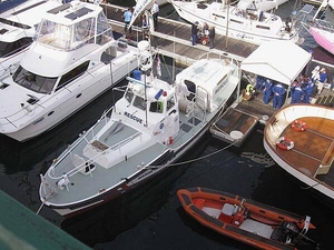
Rescue boat docked in Darling Harbour, Sydney.
Rescue boat docked in Darling Harbour, Sydney. • CIA World Factbook • 2020
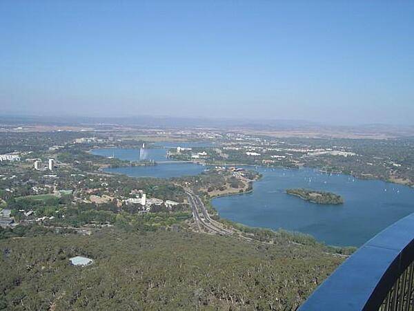
A view of Lake Burley Griffin and the south side of Canberra from Black Mountain Tower. The telecommunications tower (opened in 1980 and formerly known as the Telstra Tower) rises 195 m (640 ft) above the mountain summit.
A view of Lake Burley Griffin and the south side of Canberra from Black Mountain Tower. The telecommunications tower (opened in 1980 and formerly known as the Telstra Tower) rises 195 m (640 ft) above the mountain summit. • CIA World Factbook • 2020
CIA World Factbook • 2020
CIA World Factbook • 2020
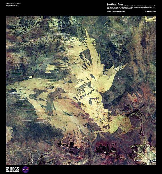
In a small corner of the vast Great Sandy Desert in Western Australia, large sand dunes - the only sand in this desert of scrub and rock - appear as lines stretching from left to right in this enhanced satellite image. The light-colored fan shapes are scars from wildfires. Image courtesy of USGS.
In a small corner of the vast Great Sandy Desert in Western Australia, large sand dunes - the only sand in this desert of scrub and rock - appear as lines stretching from left to right in this enhanced satellite image. The light-colored fan shapes are scars from wildfires. Image courtesy of USGS. • CIA World Factbook • 2020
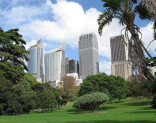
A view of the skyscrapers in downtown Sydney, near the harbor.
A view of the skyscrapers in downtown Sydney, near the harbor. • CIA World Factbook • 2020
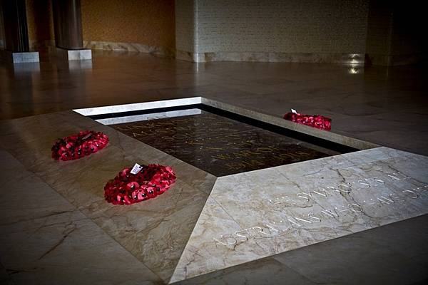
The Tomb of the Unknown Australian Soldier located in the Hall of Memory at the Australian War Memorial in Canberra, capital of Australia. The remains interred here are those of an Australian soldier killed in France during the First World War. Initially buried in the cemetery at Villers-Bretonneux in France, the body was returned to Australia and laid to rest in this tomb on 11 November 1993, the 75th anniversary of the end of the First World War. Villers-Bretonneux became famous as the scene of a counteroffensive by Australian troops in 1918. Photo courtesy of the US Marine Corps/ Sgt. Mallory S. VanderSchans.
The Tomb of the Unknown Australian Soldier located in the Hall of Memory at the Australian War Memorial in Canberra, capital of Australia. The remains interred here are those of an Australian soldier killed in France during the First World War. Initially buried in the cemetery at Villers-Bretonneux in France, the body was returned to Australia and laid to rest in this tomb on 11 November 1993, the 75th anniversary of the end of the First World War. Villers-Bretonneux became famous as the scene of a counteroffensive by Australian troops in 1918. Photo courtesy of the US Marine Corps/ Sgt. Mallory S. VanderSchans. • CIA World Factbook • 2020
CIA World Factbook • 2020
Space shuttle photo shows the Pompey Island Group in the Southern Great Barrier Reef off Australia. Ocean flow between the islands produces unique wash features in the structures of the island banks. Image courtesy of NASA.
Space shuttle photo shows the Pompey Island Group in the Southern Great Barrier Reef off Australia. Ocean flow between the islands produces unique wash features in the structures of the island banks. Image courtesy of NASA. • CIA World Factbook • 2020
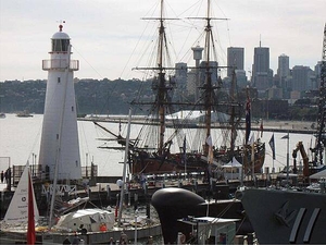
HM Bark Endeavour, a replica ship anchored at the Australian National Maritime Museum in Darling Harbour, Sydney. The original Endeavour was commanded by Lt. James Cook during his first voyage of discovery (1768-1771) where he mapped the New Zealand coast and explored the eastern coast of Australia.
HM Bark Endeavour, a replica ship anchored at the Australian National Maritime Museum in Darling Harbour, Sydney. The original Endeavour was commanded by Lt. James Cook during his first voyage of discovery (1768-1771) where he mapped the New Zealand coast and explored the eastern coast of Australia. • CIA World Factbook • 2020
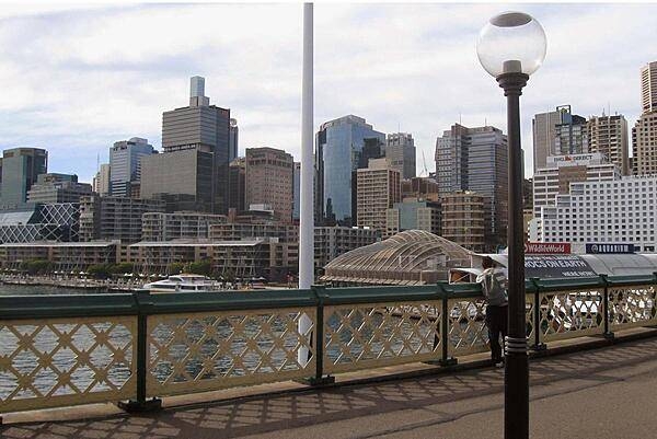
Sydney skyline as seen from a Darling Harbour footbridge.
Sydney skyline as seen from a Darling Harbour footbridge. • CIA World Factbook • 2020
CIA World Factbook • 2020
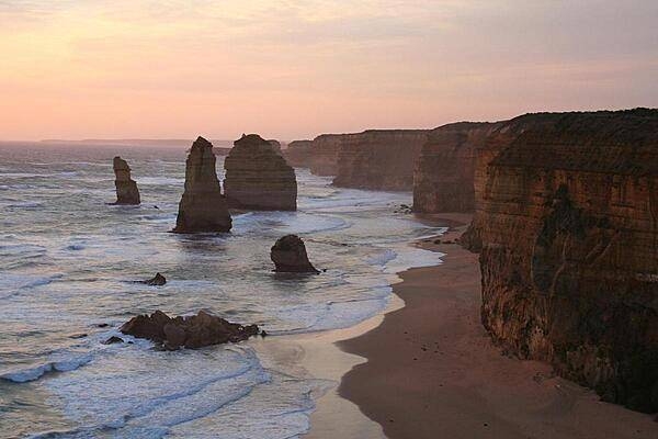
The Olgas, a red sandstone formation in the middle of the Outback.
The Olgas, a red sandstone formation in the middle of the Outback. • CIA World Factbook • 2020
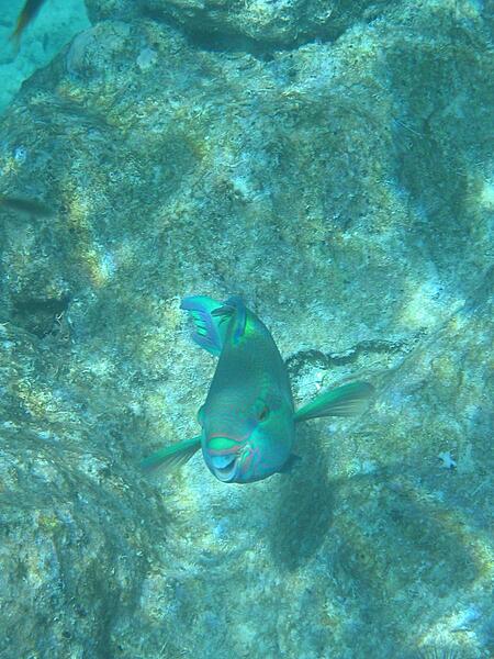
An inquisitive resident of the Great Barrier Reef.
An inquisitive resident of the Great Barrier Reef. • CIA World Factbook • 2020
CIA World Factbook • 2020
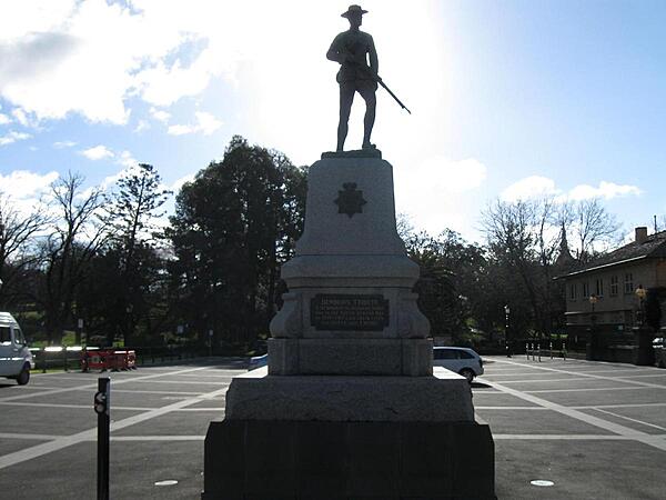
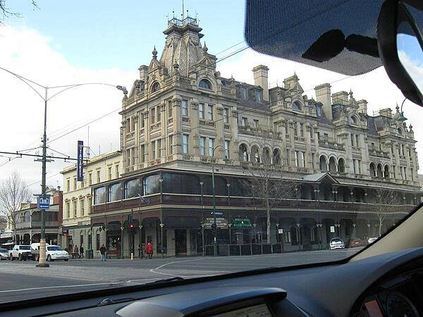
A monument in Bendigo commemorating the Australian men who fell in the South African (Boer) War (1899-1902).
A monument in Bendigo commemorating the Australian men who fell in the South African (Boer) War (1899-1902). • CIA World Factbook • 2020

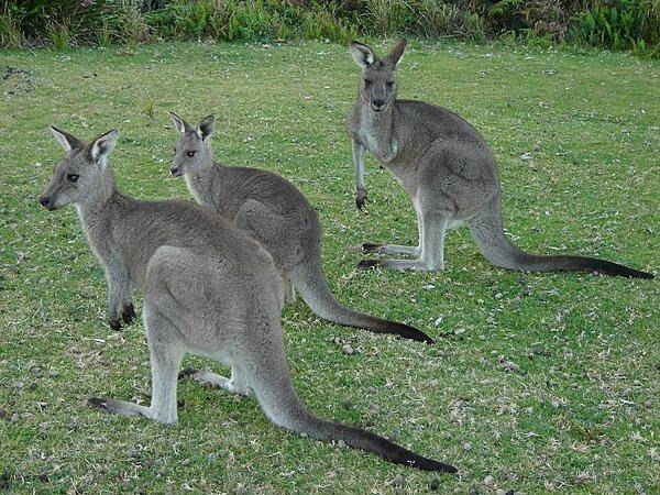
Pebbly Beach is about a 3-hr drive south of Sydney and its claim to fame is the kangaroos (aka roos) that roam around freely.
Pebbly Beach is about a 3-hr drive south of Sydney and its claim to fame is the kangaroos (aka roos) that roam around freely. • CIA World Factbook • 2020
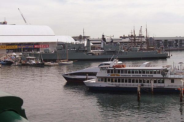
The retired naval destroyer HMAS Vampire at the Australian National Maritime Museum in Darling Harbour, Sydney.
The retired naval destroyer HMAS Vampire at the Australian National Maritime Museum in Darling Harbour, Sydney. • CIA World Factbook • 2020
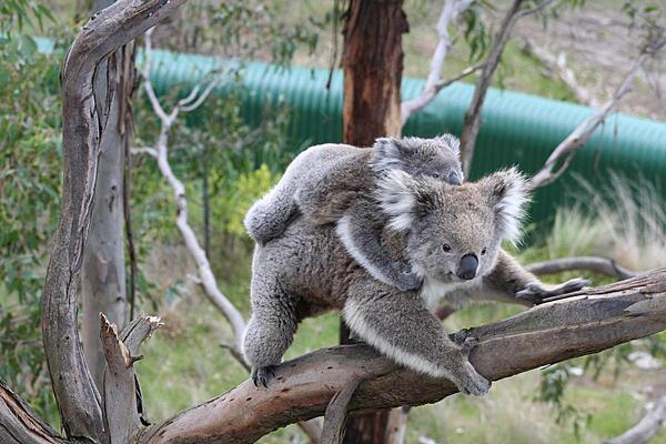
A koala female and her joey. Koalas are found in coastal regions in eastern and southern Australia. Despite the fact they are sometimes incorrectly referred to as bears, koalas are actually marsupials, usually giving birth to one offspring per year. The koala eats leaves and bark and is one of a small number of mammals capable of digesting eucalyptus leaves.
A koala female and her joey. Koalas are found in coastal regions in eastern and southern Australia. Despite the fact they are sometimes incorrectly referred to as bears, koalas are actually marsupials, usually giving birth to one offspring per year. The koala eats leaves and bark and is one of a small number of mammals capable of digesting eucalyptus leaves. • CIA World Factbook • 2020
CIA World Factbook • 2020
Media source: CIA World Factbook (2020) — Public Domain