›››
Brazil
Brazil
Population
212.0M
Rank #7Source: World Bank
Capital
Brasilia
Source: REST Countries
Region
Americas
Latin America & Caribbean
Source: REST Countries
GDP (Nominal)
$2.19T
Rank #10Source: World Bank
Land Area
8.5M km²
Rank #5Source: REST Countries
Life Expectancy
75.848 yrs
Source: World Bank
Historical Trends
Population Trend (5-Year)
Source: World Bank
GDP Trend (5-Year, Nominal USD)
Source: World Bank
Geography
Area: 8,515,767 km²
Landlocked: No
Independent: Yes
Climate: mostly tropical, but temperate in south
Terrain: mostly flat to rolling lowlands in north; some plains, hills, mountains, and narrow coastal belt
Elevation: mean elevation: 320 m lowest point: Atlantic Ocean 0 m highest point: Pico da Neblina 2,994 m
Natural Hazards: recurring droughts in northeast; floods and occasional frost in south
Environmental Issues: deforestation in Amazon Basin destroys the habitat and endangers a multitude of plant and animal species indigenous to the area; illegal wildlife trade; illegal poaching; air and water pollution in...
Land Use: agricultural land: 32.9% (2011 est.) forest: 61.9% (2011 est.) other: 5.2% (2011 est.)
Geography Note: largest country in South America and in the Southern Hemisphere; shares common boundaries with every South American country except Chile and Ecuador; most of the Pantanal, the world's largest...
Natural Resources
aluminabauxiteberylliumgoldiron oremanganesenickelniobiumphosphatesplatinum
People & Society
Fertility Rate
1.62
Population
212.0M
Ethnic Groups
White (47.7%)Mulatto (mixed White and Black) (43.1%)Black (7.6%)Asian (1.1%)Indigenous (0.4%)
Religions
Roman Catholic (64.6%)other Catholic (0.4%)Protestant 22.2% (includes Adventist (6.5%)Assembly of God (2%)Christian Congregation of Brazil (1.2%)Universal Kingdom of God (1%)other Protestant (11.5%)other Christian (0.7%)Spiritist (2.2%)other (1.4%)none (8%)unspecified (0.4%)
Economy
GDP per Capita
$10,310.549
GDP per Capita PPP
22,338.477
(2024)
(2024)
GNI per Capita
9,930
(2024)
(2024)
Gini Index
51.6
(2023)
(2023)
Unemployment
6.801%
(2024)
(2024)
Inflation
4.367%
(2024)
(2024)
Public Debt
81.855%
(2024)
(2024)
Energy
Electricity Access
99.8%
(2023)
(2023)
Renewable Energy
46.5%
(2021)
(2021)
CO₂ Emissions
491.469 Mt
(2024)
(2024)
Energy Intensity
3.87 MJ/$
(2022)
(2022)
Renewable Electricity
77.375%
(2021)
(2021)
Environment
Forest Coverage
58.982% of land
(2023)
(2023)
Communications
Internet Users
84.464%
(2024)
(2024)
Mobile Penetration
101.02%
(2023)
(2023)
Broadband Subscribers
22.419%
(2023)
(2023)
Transportation
Air Transport Freight
1,387.083 M ton-km
(2023)
(2023)
Container Port Traffic
11,683,239 TEU
(2022)
(2022)
Airports
791,523
Rail Lines
N/A
Roads Total
1,563,600 km(©IRF)
Military
Military Forces
Brazilian Armed Forces: Brazilian Army (Exercito Brasileiro, EB), Brazilian Navy (Marinha do Brasil, MB, includes Naval Aviation and Marine Corps (Corpo de Fuzileiros Navais)), Brazilian Air Force...
Personnel Strength
size assessments for the Brazilian Armed Forces vary; approximately 360,000 active personnel (215,000 Army; 75,000 Navy; 70,000 Air Force)
Military Expenditure (USD)
$20.95B
Military Expenditure (% of GDP)
0.97%
Military Expenditure History
1.5% of GDP (2019) 1.5% of GDP (2018) 1.4% of GDP (2017) 1.4% of GDP (2016) 1.4% of GDP (2015)
Deployments
220 Lebanon (UNIFIL) (2020)
Equipment & Inventories
the Brazilian military's inventory consists of a mix of domestically-produced and imported weapons, largely from Europe and the US; since 2010, France, Germany, the UK, and the US are the leading...
Service Age & Obligation
18-45 years of age for compulsory military service; conscript service obligation is 10-12 months; 17-45 years of age for voluntary service; an increasing percentage of the ranks are "long-service"...
Education
Pre-Primary Enrollment
85.942%
(2020)
(2020)
Primary Enrollment
103.97%
(2022)
(2022)
Secondary Enrollment
106.031%
(2022)
(2022)
Tertiary Enrollment
60.391%
(2022)
(2022)
Education Spending
5.619% of GDP
(2022)
(2022)
Adult Literacy Rate
94.801%
(2024)
(2024)
Pupil-Teacher Ratio
20.223:1
(2017)
(2017)
Health
Physicians per 1,000
2.357
(2023)
(2023)
Safe Water Access
100%
(2024)
(2024)
Safe Drinking Water
88.624%
(2024)
(2024)
Under-5 Mortality
14.4 per 1,000
(2023)
(2023)
Maternal Mortality (World Bank)
17.588 per 100,000
(2021)
(2021)
Hospital Beds per 1,000
72.388
(2021)
(2021)
UHC Coverage Index
84
(2023)
(2023)
Measles Immunization
91%
(2024)
(2024)
Social Indicators
Extreme Poverty Rate
3.8%
(2023)
(2023)
Food Insecurity
2.5%
(2023)
(2023)
Youth NEET Rate
15.704%
(2024)
(2024)
Governance
Women in Government
17.544%
(2024)
(2024)
Voice & Accountability
0.38
(Above Average)
(2023)
(Above Average)
(2023)
Political Stability
-0.41
(Below Average)
(2023)
(Below Average)
(2023)
Government Effectiveness
-0.55
(Below Average)
(2023)
(Below Average)
(2023)
Regulatory Quality
-0.30
(Below Average)
(2023)
(Below Average)
(2023)
Rule of Law
-0.31
(Below Average)
(2023)
(Below Average)
(2023)
Control of Corruption
-0.50
(Below Average)
(2023)
(Below Average)
(2023)
Government
Government Type
federal presidential republic
Legal System
civil law; note - a new civil law code was enacted in 2002 replacing the 1916 code
Executive Branch
chief of state: President Jair BOLSONARO (since 1 January 2019); Vice President Antonio Hamilton Martins MOURAO (since 1 January 2019); note - the president is both chief of state and head of...
Legislative Branch
description: bicameral National Congress or Congresso Nacional consists of:Federal Senate or Senado Federal (81 seats; 3 members each from 26 states and 3 from the federal district directly elected...
Judicial Branch
highest courts: Supreme Federal Court or Supremo Tribunal Federal (consists of 11 justices) judge selection and term of office: justices appointed by the president and approved by the Federal Senate;...
International Organizations
National Symbols
Flag Description
green with a large yellow diamond in the center bearing a blue celestial globe with 27 white five-pointed stars; the globe has a white equatorial band with the motto ORDEM E PROGRESSO (Order and...
National Symbols
Southern Cross constellation; national colors: green, yellow, blue
National Anthem
name: "Hino Nacional Brasileiro" (Brazilian National Anthem) lyrics/music: Joaquim Osorio Duque ESTRADA/Francisco Manoel DA SILVA note: music adopted 1890, lyrics adopted 1922; the anthem's music,...
Safety
Homicide Rate
19.275 per 100,000
(2023)
(2023)
Travel Information
Language(s): Portuguese
Currency: BRL (R$)
Timezone(s): UTC -02:00 to -05:00
Landlocked: No
Independent: Yes
Driving Side: Right
Calling Code: +55
Car Sign: BR
Week Starts: Sunday
Photos
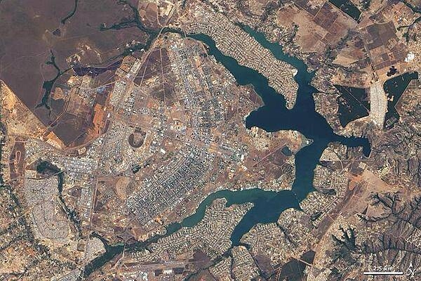
Brazil's earliest national capitals - Salvador and Rio de Janeiro - were coastal cities. Although these sites were well suited to trade, they were vulnerable to maritime raids. In the late 19th century, Brazilian leaders resolved to move the capital city inland. Large-scale construction of a new site, however, did not begin until the 1950s. On 22 April 1960, the nearly complete capital city of Brasilia opened. The city's pioneer status in urban planning prompted UNESCO to name Brasilia a World Heritage Site in 1987. This natural-color satellite image of Brasilia taken during the summer dry season - with just 3 cm (1 in) of rain - displays earth tones characteristic of non-irrigated dormant vegetation. Buildings and roads appear off-white, gray, or pale tan. The city, whose overall design has been compared to a bird or an airplane, among other shapes, sits west of an artificial lake, Lago Paranoa. The branching lake sends its tendrils deep into the city, helping separate the downtown area (image center) from residential areas to the north and southeast. Northwest of the city lies Brasilia National Park, protecting a large expanse of cerrado, the tropical savanna ecosystem natural to the area. Image courtesy of NASA.
Brazil's earliest national capitals - Salvador and Rio de Janeiro - were coastal cities. Although these sites were well suited to trade, they were vulnerable to maritime raids. In the late 19th century, Brazilian leaders resolved to move the capital city inland. Large-scale construction of a new site, however, did not begin until the 1950s. On 22 April 1960, the nearly complete capital city of Brasilia opened. The city's pioneer status in urban planning prompted UNESCO to name Brasilia a World Heritage Site in 1987. This natural-color satellite image of Brasilia taken during the summer dry season - with just 3 cm (1 in) of rain - displays earth tones characteristic of non-irrigated dormant vegetation. Buildings and roads appear off-white, gray, or pale tan. The city, whose overall design has been compared to a bird or an airplane, among other shapes, sits west of an artificial lake, Lago Paranoa. The branching lake sends its tendrils deep into the city, helping separate the downtown area (image center) from residential areas to the north and southeast. Northwest of the city lies Brasilia National Park, protecting a large expanse of cerrado, the tropical savanna ecosystem natural to the area. Image courtesy of NASA. • CIA World Factbook • 2020
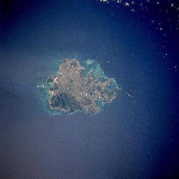
The island of Antigua shows severely eroded volcanic remnants along its forested southwestern quadrant. Although Antigua receives approximately 100 cm (40 in) of precipitation annually, wide fluctuations in rainfall amounts occasionally create serious water shortages, especially for the agricultural industry. St. John's, the country's capital, is located along the northwest coast, adjacent to one of the island's many natural harbors. More than half of the country's population lives in the St. John's area. Image courtesy of NASA.
The island of Antigua shows severely eroded volcanic remnants along its forested southwestern quadrant. Although Antigua receives approximately 100 cm (40 in) of precipitation annually, wide fluctuations in rainfall amounts occasionally create serious water shortages, especially for the agricultural industry. St. John's, the country's capital, is located along the northwest coast, adjacent to one of the island's many natural harbors. More than half of the country's population lives in the St. John's area. Image courtesy of NASA. • CIA World Factbook • 2020
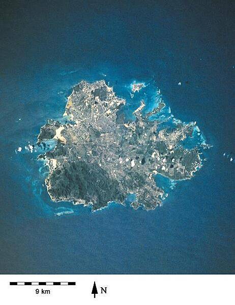
A closer view of the island of Antigua shows severely eroded volcanic remnants along its forested southwestern quadrant. Although Antigua receives approximately 100 cm (40 in) of precipitation annually, wide fluctuations in rainfall amounts occasionally create serious water shortages, especially for the agricultural industry. St. John's, the country's capital, is located along the northwest coast, adjacent to one of the island's many natural harbors. More than half of the country's population lives in the St. John's area. Image courtesy of NASA.
A closer view of the island of Antigua shows severely eroded volcanic remnants along its forested southwestern quadrant. Although Antigua receives approximately 100 cm (40 in) of precipitation annually, wide fluctuations in rainfall amounts occasionally create serious water shortages, especially for the agricultural industry. St. John's, the country's capital, is located along the northwest coast, adjacent to one of the island's many natural harbors. More than half of the country's population lives in the St. John's area. Image courtesy of NASA. • CIA World Factbook • 2020
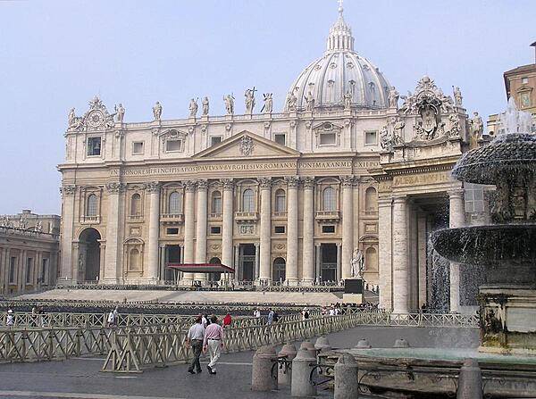
The facade of St. Peter's Basilica as viewed from next to one of the two matching Bernini fountains that grace St. Peter's Square (Piazza) in front of the church. The attic or upper story displays statues of Christ, his apostles, and St. John the Baptist. Constructed over a period of 80 years and consecrated in 1626, the basilica is the largest Christian church in the world - capable of holding some 60,000 people.
The facade of St. Peter's Basilica as viewed from next to one of the two matching Bernini fountains that grace St. Peter's Square (Piazza) in front of the church. The attic or upper story displays statues of Christ, his apostles, and St. John the Baptist. Constructed over a period of 80 years and consecrated in 1626, the basilica is the largest Christian church in the world - capable of holding some 60,000 people. • CIA World Factbook • 2020
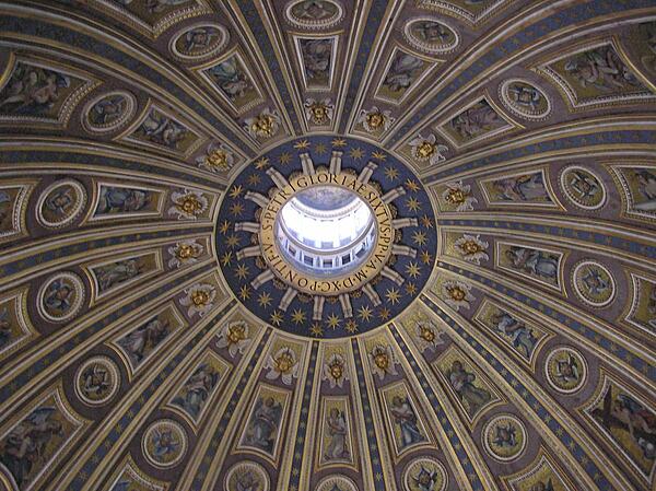
The interior dome of St. Peter's Basilica.
The interior dome of St. Peter's Basilica. • CIA World Factbook • 2020
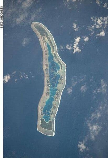
Millennium Island - known as Caroline Island prior to 2000 - is located at the southern end of the Line Islands, which make up the western portion of Kiribati. Uninhabited Millennium Island is formed from a number of smaller islets built on coral reefs. The reefs grew around a now-submerged volcanic peak, leaving a ring of coral around an inner lagoon. The shallow lagoon waters are a lighter blue than the deeper surrounding ocean water; tan linear "fingers" within the lagoon are the tops of corals. The two largest islets are Nake Islet (on the north) and South Islet. Image courtesy of NASA.
Millennium Island - known as Caroline Island prior to 2000 - is located at the southern end of the Line Islands, which make up the western portion of Kiribati. Uninhabited Millennium Island is formed from a number of smaller islets built on coral reefs. The reefs grew around a now-submerged volcanic peak, leaving a ring of coral around an inner lagoon. The shallow lagoon waters are a lighter blue than the deeper surrounding ocean water; tan linear "fingers" within the lagoon are the tops of corals. The two largest islets are Nake Islet (on the north) and South Islet. Image courtesy of NASA. • CIA World Factbook • 2020
41 photos available
View All Photos→Data sources: World Bank, UN Data • Updated daily •Learn about our data