›››
Brazil — Media Gallery
41 items available (flags, maps, photos)
Photos
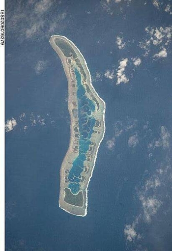
Millennium Island - known as Caroline Island prior to 2000 - is located at the southern end of the Line Islands, which make up the western portion of Kiribati. Uninhabited Millennium Island is formed from a number of smaller islets built on coral reefs. The reefs grew around a now-submerged volcanic peak, leaving a ring of coral around an inner lagoon. The shallow lagoon waters are a lighter blue than the deeper surrounding ocean water; tan linear "fingers" within the lagoon are the tops of corals. The two largest islets are Nake Islet (on the north) and South Islet. Image courtesy of NASA.
Millennium Island - known as Caroline Island prior to 2000 - is located at the southern end of the Line Islands, which make up the western portion of Kiribati. Uninhabited Millennium Island is formed from a number of smaller islets built on coral reefs. The reefs grew around a now-submerged volcanic peak, leaving a ring of coral around an inner lagoon. The shallow lagoon waters are a lighter blue than the deeper surrounding ocean water; tan linear "fingers" within the lagoon are the tops of corals. The two largest islets are Nake Islet (on the north) and South Islet. Image courtesy of NASA. • CIA World Factbook • 2020
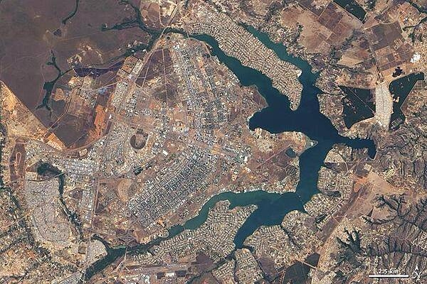
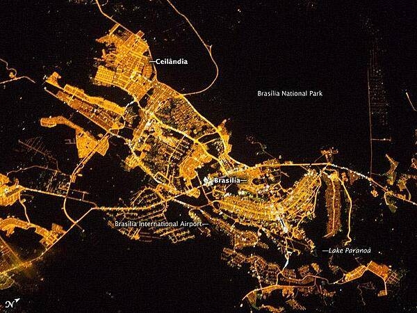
Brazil's earliest national capitals - Salvador and Rio de Janeiro - were coastal cities. Although these sites were well suited to trade, they were vulnerable to maritime raids. In the late 19th century, Brazilian leaders resolved to move the capital city inland. Large-scale construction of a new site, however, did not begin until the 1950s. On 22 April 1960, the nearly complete capital city of Brasilia opened. The city's pioneer status in urban planning prompted UNESCO to name Brasilia a World Heritage Site in 1987. This natural-color satellite image of Brasilia taken during the summer dry season - with just 3 cm (1 in) of rain - displays earth tones characteristic of non-irrigated dormant vegetation. Buildings and roads appear off-white, gray, or pale tan. The city, whose overall design has been compared to a bird or an airplane, among other shapes, sits west of an artificial lake, Lago Paranoa. The branching lake sends its tendrils deep into the city, helping separate the downtown area (image center) from residential areas to the north and southeast. Northwest of the city lies Brasilia National Park, protecting a large expanse of cerrado, the tropical savanna ecosystem natural to the area. Image courtesy of NASA.
Brazil's earliest national capitals - Salvador and Rio de Janeiro - were coastal cities. Although these sites were well suited to trade, they were vulnerable to maritime raids. In the late 19th century, Brazilian leaders resolved to move the capital city inland. Large-scale construction of a new site, however, did not begin until the 1950s. On 22 April 1960, the nearly complete capital city of Brasilia opened. The city's pioneer status in urban planning prompted UNESCO to name Brasilia a World Heritage Site in 1987. This natural-color satellite image of Brasilia taken during the summer dry season - with just 3 cm (1 in) of rain - displays earth tones characteristic of non-irrigated dormant vegetation. Buildings and roads appear off-white, gray, or pale tan. The city, whose overall design has been compared to a bird or an airplane, among other shapes, sits west of an artificial lake, Lago Paranoa. The branching lake sends its tendrils deep into the city, helping separate the downtown area (image center) from residential areas to the north and southeast. Northwest of the city lies Brasilia National Park, protecting a large expanse of cerrado, the tropical savanna ecosystem natural to the area. Image courtesy of NASA. • CIA World Factbook • 2020
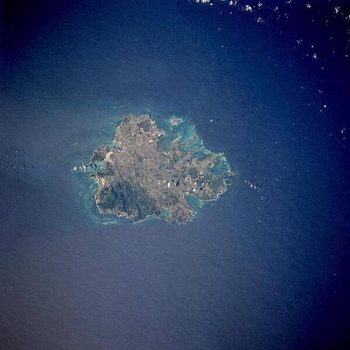
The island of Antigua shows severely eroded volcanic remnants along its forested southwestern quadrant. Although Antigua receives approximately 100 cm (40 in) of precipitation annually, wide fluctuations in rainfall amounts occasionally create serious water shortages, especially for the agricultural industry. St. John's, the country's capital, is located along the northwest coast, adjacent to one of the island's many natural harbors. More than half of the country's population lives in the St. John's area. Image courtesy of NASA.
The island of Antigua shows severely eroded volcanic remnants along its forested southwestern quadrant. Although Antigua receives approximately 100 cm (40 in) of precipitation annually, wide fluctuations in rainfall amounts occasionally create serious water shortages, especially for the agricultural industry. St. John's, the country's capital, is located along the northwest coast, adjacent to one of the island's many natural harbors. More than half of the country's population lives in the St. John's area. Image courtesy of NASA. • CIA World Factbook • 2020
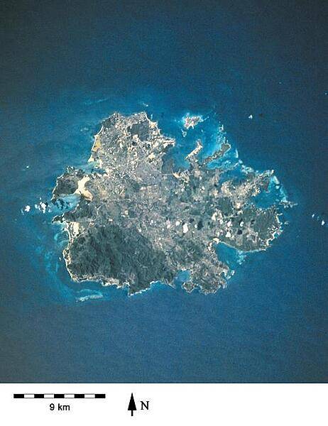
A closer view of the island of Antigua shows severely eroded volcanic remnants along its forested southwestern quadrant. Although Antigua receives approximately 100 cm (40 in) of precipitation annually, wide fluctuations in rainfall amounts occasionally create serious water shortages, especially for the agricultural industry. St. John's, the country's capital, is located along the northwest coast, adjacent to one of the island's many natural harbors. More than half of the country's population lives in the St. John's area. Image courtesy of NASA.
A closer view of the island of Antigua shows severely eroded volcanic remnants along its forested southwestern quadrant. Although Antigua receives approximately 100 cm (40 in) of precipitation annually, wide fluctuations in rainfall amounts occasionally create serious water shortages, especially for the agricultural industry. St. John's, the country's capital, is located along the northwest coast, adjacent to one of the island's many natural harbors. More than half of the country's population lives in the St. John's area. Image courtesy of NASA. • CIA World Factbook • 2020
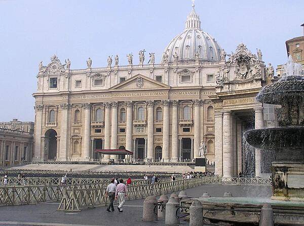
The facade of St. Peter's Basilica as viewed from next to one of the two matching Bernini fountains that grace St. Peter's Square (Piazza) in front of the church. The attic or upper story displays statues of Christ, his apostles, and St. John the Baptist. Constructed over a period of 80 years and consecrated in 1626, the basilica is the largest Christian church in the world - capable of holding some 60,000 people.
The facade of St. Peter's Basilica as viewed from next to one of the two matching Bernini fountains that grace St. Peter's Square (Piazza) in front of the church. The attic or upper story displays statues of Christ, his apostles, and St. John the Baptist. Constructed over a period of 80 years and consecrated in 1626, the basilica is the largest Christian church in the world - capable of holding some 60,000 people. • CIA World Factbook • 2020
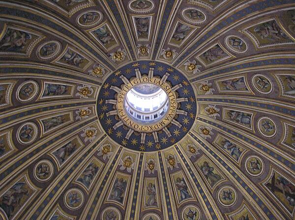
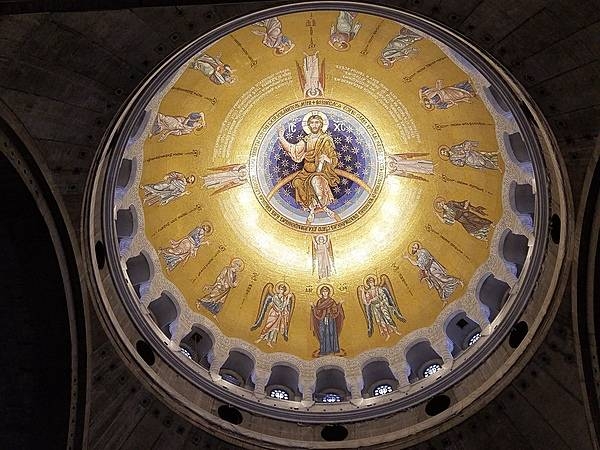
The interior dome of St. Peter's Basilica.
The interior dome of St. Peter's Basilica. • CIA World Factbook • 2020
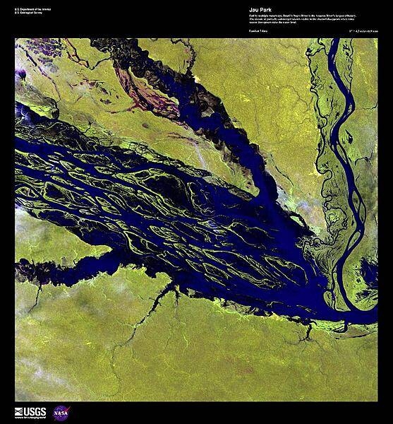
This photograph shows a section of the Negro River in Jau National Park, Amazonas state. Fed by multiple waterways, the Negro River is the Amazon's largest tributary. The mosaic of partially-submerged islands visible in the channel of this enhanced satellite image disappears when rainy season downpours raise the water level. Jau National Park is South America's largest forest reserve, covering 23,000 sq km (8,900 sq mi); it is listed as a UNESCO World Heritage Site. Image courtesy of USGS.
This photograph shows a section of the Negro River in Jau National Park, Amazonas state. Fed by multiple waterways, the Negro River is the Amazon's largest tributary. The mosaic of partially-submerged islands visible in the channel of this enhanced satellite image disappears when rainy season downpours raise the water level. Jau National Park is South America's largest forest reserve, covering 23,000 sq km (8,900 sq mi); it is listed as a UNESCO World Heritage Site. Image courtesy of USGS. • CIA World Factbook • 2020
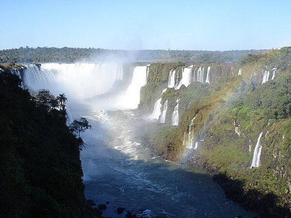
The majestic Iguazu Falls on the Argentine-Brazil border. The falls are part of a nearly virgin jungle ecosystem surrounded by national parks on both sides of the cascades. The Iguazu River begins in Parana state of Brazil, then crosses a 1,200-km (750 mi) plateau before reaching a series of faults forming the falls.
The majestic Iguazu Falls on the Argentine-Brazil border. The falls are part of a nearly virgin jungle ecosystem surrounded by national parks on both sides of the cascades. The Iguazu River begins in Parana state of Brazil, then crosses a 1,200-km (750 mi) plateau before reaching a series of faults forming the falls. • CIA World Factbook • 2020
CIA World Factbook • 2020
CIA World Factbook • 2020
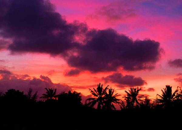
Glorious sunset at Johnston Atoll National Wildlife Refuge. Image courtesy of USFWS/Laura M. Beauregard.
Glorious sunset at Johnston Atoll National Wildlife Refuge. Image courtesy of USFWS/Laura M. Beauregard. • CIA World Factbook • 2020
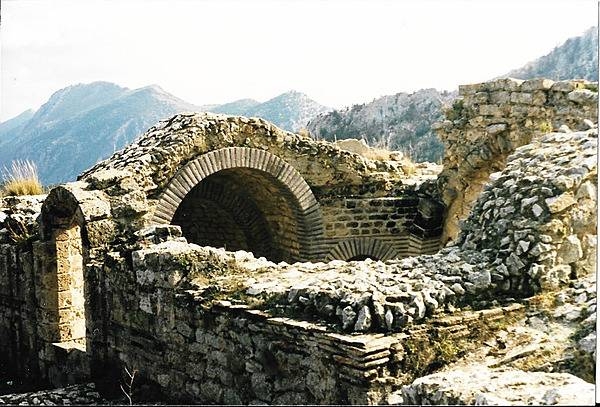
Some of the vaulting remains of the church at Saint Hilarion Castle in the Kyrenia Mountains of Northern Cyprus.
Some of the vaulting remains of the church at Saint Hilarion Castle in the Kyrenia Mountains of Northern Cyprus. • CIA World Factbook • 2020
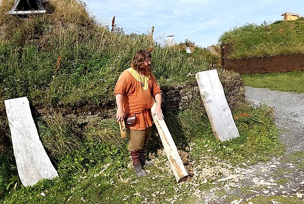
A Norse-period interpreter at L’Anse Aux Meadows planing logs.
A Norse-period interpreter at L’Anse Aux Meadows planing logs. • CIA World Factbook • 2020
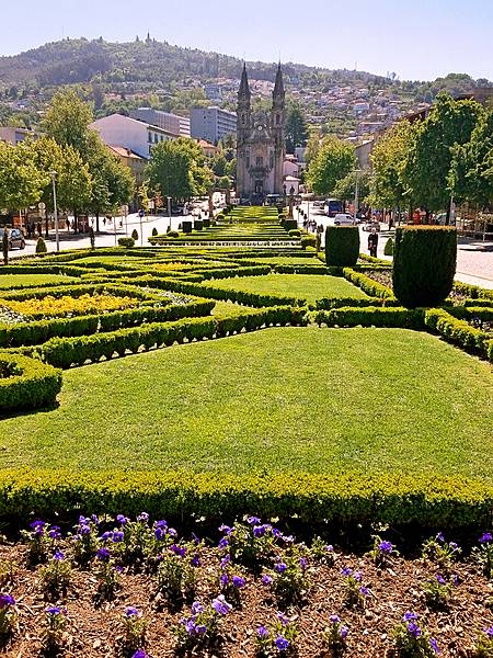
The medieval section of Guimaraes opens onto the “Largo Republica do Brasil (Republic Square of Brazil)” with its formal flower gardens. One end of the square features the slim Nossa Senhora da Consolacao e dos Santos Passos (Church of Our Lady of Consolation and the Holy Steps), one of the loveliest examples of Portuguese Baroque architecture.
The medieval section of Guimaraes opens onto the “Largo Republica do Brasil (Republic Square of Brazil)” with its formal flower gardens. One end of the square features the slim Nossa Senhora da Consolacao e dos Santos Passos (Church of Our Lady of Consolation and the Holy Steps), one of the loveliest examples of Portuguese Baroque architecture. • CIA World Factbook • 2020
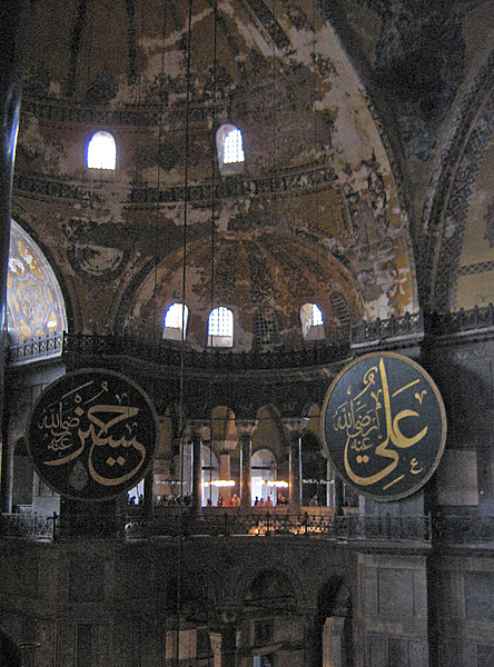
A view of the interior of the Hagia Sophia.
A view of the interior of the Hagia Sophia. • CIA World Factbook • 2020
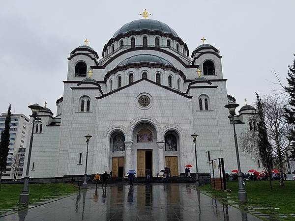
The Church of Saint Sava in Belgrade. Sava was the founder of the Serbian Orthodox Church. Construction on the structure, one of the largest Orthodox churches in the world, began in 1935 but was interrupted many times because of various conflicts.
The Church of Saint Sava in Belgrade. Sava was the founder of the Serbian Orthodox Church. Construction on the structure, one of the largest Orthodox churches in the world, began in 1935 but was interrupted many times because of various conflicts. • CIA World Factbook • 2020
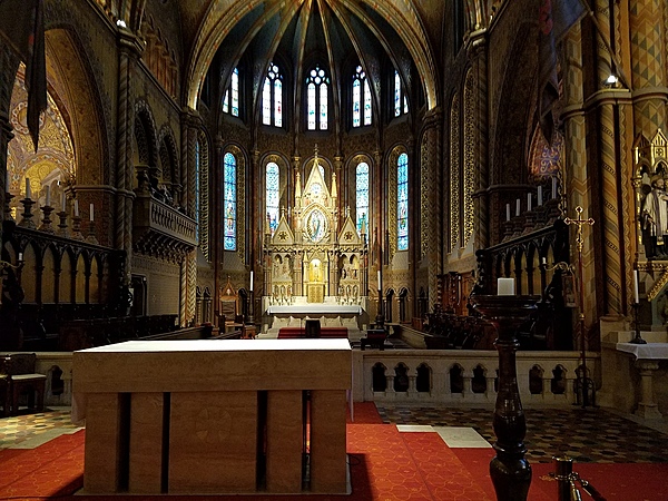
Part of the interior of the Church of the Assumption in Buda's Castle District.
Part of the interior of the Church of the Assumption in Buda's Castle District. • CIA World Factbook • 2020
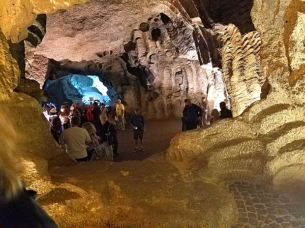
The interior of the Hercules Caves near Tangier. The Atlantic Ocean waters flood the caves at high tide.
The interior of the Hercules Caves near Tangier. The Atlantic Ocean waters flood the caves at high tide. • CIA World Factbook • 2020
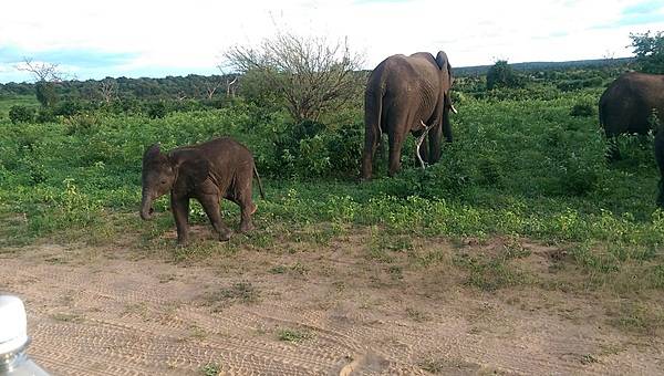
A curious baby elephant approaches a safari vehicle.
A curious baby elephant approaches a safari vehicle. • CIA World Factbook • 2020
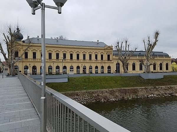
Radnicki Dom (Workers' Hall), formerly the Grand Hotel, is one of Vukovar's most famous architectural landmarks. From its opening in 1897 until its wartime destruction in 1991, it was the social and cultural center for the town's diverse population. The impetus to rebuild Workers' Hall came from the European Parliament, as part of an initiative to encourage post-conflict recovery and reconciliation through the restoration of architectural monuments destroyed in the 1991-95 war. The faithful reconstruction of the exterior, roof, and basement took two years (May 2011-April 2013) and cost €1.64 million. Fund-raising continues to rebuild the interior, estimated to cost €2.75 million.
Radnicki Dom (Workers' Hall), formerly the Grand Hotel, is one of Vukovar's most famous architectural landmarks. From its opening in 1897 until its wartime destruction in 1991, it was the social and cultural center for the town's diverse population. The impetus to rebuild Workers' Hall came from the European Parliament, as part of an initiative to encourage post-conflict recovery and reconciliation through the restoration of architectural monuments destroyed in the 1991-95 war. The faithful reconstruction of the exterior, roof, and basement took two years (May 2011-April 2013) and cost €1.64 million. Fund-raising continues to rebuild the interior, estimated to cost €2.75 million. • CIA World Factbook • 2020
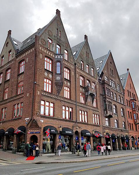
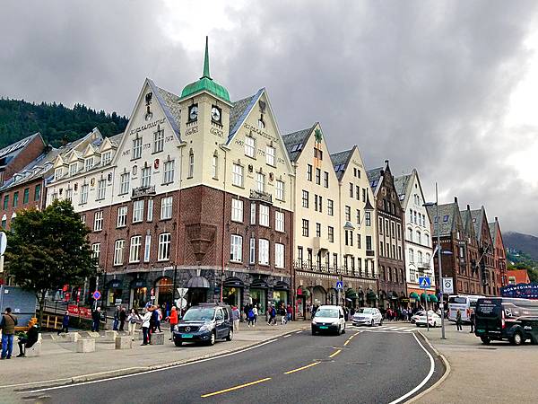
Larger warehouses were built along the Hanseatic Wharf in Bergen after periodic fires destroyed the original buildings.
Larger warehouses were built along the Hanseatic Wharf in Bergen after periodic fires destroyed the original buildings. • CIA World Factbook • 2020
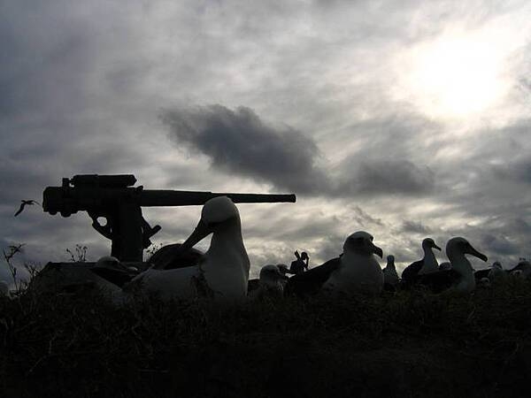
Remnant of the historic Battle of Midway, this anti-aircraft gun at Eastern Island in Midway Atoll National Wildlife Refuge is surrounded by nesting albatross. On 13 September 2000, the Secretary of the Interior designated the lands and waters of Midway Atoll National Wildlife Refuge as the Battle of Midway National Memorial, “so that the heroic courage and sacrifice of those who fought against overwhelming odds to win an incredible victory will never be forgotten.” This is the first National Memorial to be designated on a National Wildlife Refuge. Photo courtesy of USFWS/David Patte.
Remnant of the historic Battle of Midway, this anti-aircraft gun at Eastern Island in Midway Atoll National Wildlife Refuge is surrounded by nesting albatross. On 13 September 2000, the Secretary of the Interior designated the lands and waters of Midway Atoll National Wildlife Refuge as the Battle of Midway National Memorial, “so that the heroic courage and sacrifice of those who fought against overwhelming odds to win an incredible victory will never be forgotten.” This is the first National Memorial to be designated on a National Wildlife Refuge. Photo courtesy of USFWS/David Patte. • CIA World Factbook • 2020
Interior dome of the Church of Saint Sava in Belgrade.
Interior dome of the Church of Saint Sava in Belgrade. • CIA World Factbook • 2020
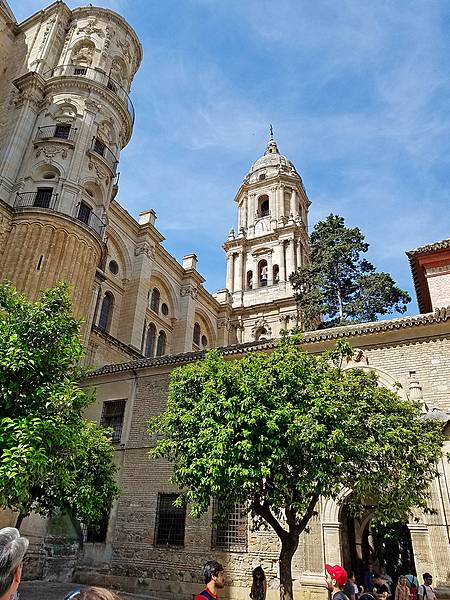
The Catedral Basílica de la Encarnación (Cathedral Basilica of the Incarnation) in Malaga was constructed over a 250-year period (between 1528 and 1782).
The Catedral Basílica de la Encarnación (Cathedral Basilica of the Incarnation) in Malaga was constructed over a 250-year period (between 1528 and 1782). • CIA World Factbook • 2020
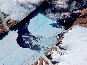
The Petermann Glacier grinds and slides toward the sea along the northwestern coast of Greenland, terminating in a giant floating ice tongue. Like other glaciers that end in the ocean, Petermann periodically calves icebergs. In July 2012, a massive ice island broke free and gradually drifted down the fjord, away from the floating ice tongue from which it calved. This satellite image has been rotated and north is toward the right. Analysis of the image reveals that the iceberg covers an area of about 32.3 sq km (12.5 sq mi). Image courtesy of NASA.
The Petermann Glacier grinds and slides toward the sea along the northwestern coast of Greenland, terminating in a giant floating ice tongue. Like other glaciers that end in the ocean, Petermann periodically calves icebergs. In July 2012, a massive ice island broke free and gradually drifted down the fjord, away from the floating ice tongue from which it calved. This satellite image has been rotated and north is toward the right. Analysis of the image reveals that the iceberg covers an area of about 32.3 sq km (12.5 sq mi). Image courtesy of NASA. • CIA World Factbook • 2020
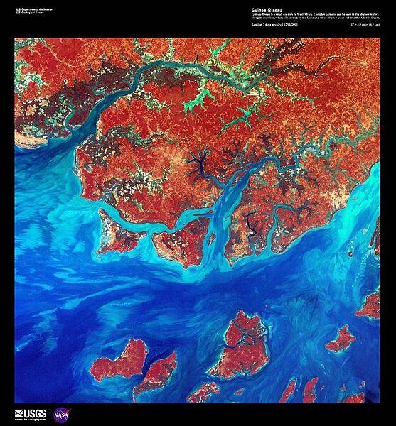
A false-color satellite image of the Guinea-Bissau coastline shows numerous offshore islands, part of the Bissagos Islands. Plains and Guinean mangroves, various kinds of trees and shrubs adapted to thrive in the saline coastal sediment habitats, dominate the coastline of Guinea-Bissau. In the shallow waters, silt - carried into the Atlantic Ocean by the Geba and other rivers - is deposited in various complex patterns. Image courtesy of USGS.
A false-color satellite image of the Guinea-Bissau coastline shows numerous offshore islands, part of the Bissagos Islands. Plains and Guinean mangroves, various kinds of trees and shrubs adapted to thrive in the saline coastal sediment habitats, dominate the coastline of Guinea-Bissau. In the shallow waters, silt - carried into the Atlantic Ocean by the Geba and other rivers - is deposited in various complex patterns. Image courtesy of USGS. • CIA World Factbook • 2020
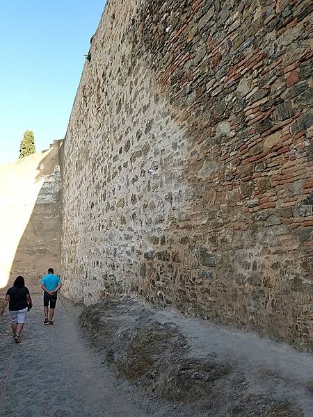
The stone walls in the Alcazaba in Malaga show different periods of construction. The Alcazaba is a complex of palaces that sits high atop a hillside. It was built by the Moors in the 11th century and formerly connected to the Gibralfaro fortification that overlooks the city and is situated higher still.
The stone walls in the Alcazaba in Malaga show different periods of construction. The Alcazaba is a complex of palaces that sits high atop a hillside. It was built by the Moors in the 11th century and formerly connected to the Gibralfaro fortification that overlooks the city and is situated higher still. • CIA World Factbook • 2020
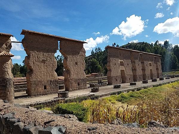
Central wall of the huge two-story Inca Temple of Viracocha at Raqchi; the remains are some 100 m long and 14 m high. The original building consisted of a central adobe wall some 18 to 20 meters in height with a cut stone foundation base. Windows and doors allowed passage from one side to the other. The central wall was flanked on either side by a row of eleven columns. The foundations for both the wall and the columns were constructed of classic high Inca stonework with the remaining height built of adobe. (The 4 m height of the wall foundation survives, but most of the column heights have been reduced.) Prior to its destruction by the Spaniards, the temple had what was likely the largest single gable roof in the Incan Empire, with its peak at the central wall and stretching out over the columns on each side. The site is at 3,480 m above sea level and 110 km from Cusco.
Central wall of the huge two-story Inca Temple of Viracocha at Raqchi; the remains are some 100 m long and 14 m high. The original building consisted of a central adobe wall some 18 to 20 meters in height with a cut stone foundation base. Windows and doors allowed passage from one side to the other. The central wall was flanked on either side by a row of eleven columns. The foundations for both the wall and the columns were constructed of classic high Inca stonework with the remaining height built of adobe. (The 4 m height of the wall foundation survives, but most of the column heights have been reduced.) Prior to its destruction by the Spaniards, the temple had what was likely the largest single gable roof in the Incan Empire, with its peak at the central wall and stretching out over the columns on each side. The site is at 3,480 m above sea level and 110 km from Cusco. • CIA World Factbook • 2020
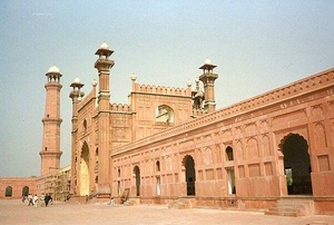
The entrance to the Badshahi Mosque, or “imperial mosque,” as viewed from the mosque courtyard. The mosque, built by the Mughal emperor Aurangzeb from 1671-1673, is the last great mosque built during the Mughal period; its courtyard can accommodate 100,000 worshipers. The gateway leads out to the garden known as Hazuri Bagh, beyond which is the Alamgiri gate of the Lahore Fort.
The entrance to the Badshahi Mosque, or “imperial mosque,” as viewed from the mosque courtyard. The mosque, built by the Mughal emperor Aurangzeb from 1671-1673, is the last great mosque built during the Mughal period; its courtyard can accommodate 100,000 worshipers. The gateway leads out to the garden known as Hazuri Bagh, beyond which is the Alamgiri gate of the Lahore Fort. • CIA World Factbook • 2020
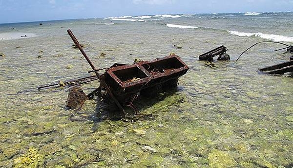
Wreckage scattered and pushed around the reef flat and rubble spit at Kingman Reef National Wildlife Refuge causes considerable damage and must be periodically removed. Image courtesy USFWS.
Wreckage scattered and pushed around the reef flat and rubble spit at Kingman Reef National Wildlife Refuge causes considerable damage and must be periodically removed. Image courtesy USFWS. • CIA World Factbook • 2020
Larger warehouses were built along the Hanseatic Wharf in Bergen after periodic fires destroyed the original buildings.
Larger warehouses were built along the Hanseatic Wharf in Bergen after periodic fires destroyed the original buildings. • CIA World Factbook • 2020
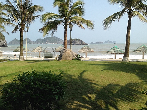
Cat Ba Island has a wide variety of natural ecosystems, both marine and terrestrial, leading to incredibly high rates of biodiversity. While most of the interior is a national park, much of the island's coast has been converted to resorts.
Cat Ba Island has a wide variety of natural ecosystems, both marine and terrestrial, leading to incredibly high rates of biodiversity. While most of the interior is a national park, much of the island's coast has been converted to resorts. • CIA World Factbook • 2020
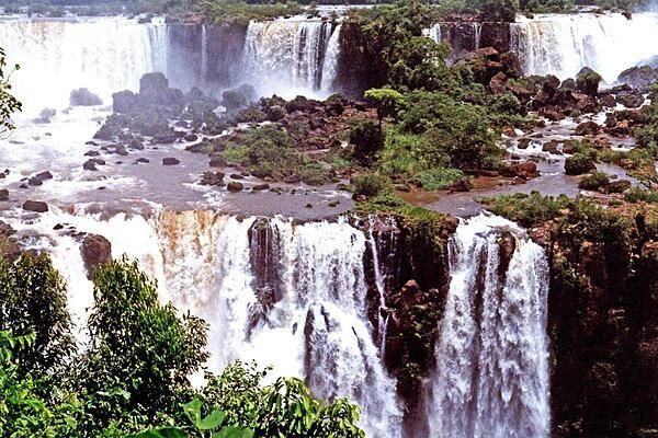
A panoramic view of Iguazu Falls along the Brazil-Argentina border. The entire waterfall system consists of some 275 falls along 2.7 km (1.7 mi) of the Iguazu River.
A panoramic view of Iguazu Falls along the Brazil-Argentina border. The entire waterfall system consists of some 275 falls along 2.7 km (1.7 mi) of the Iguazu River. • CIA World Factbook • 2020
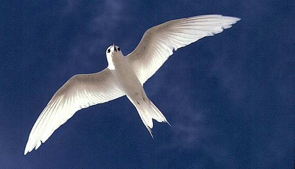
The white tern is famous for laying its egg on a rock, a rock ledge, or a bare branch rather than in a nest. An egg laid in an exposed and precarious place results in a chick that must cling to the perch. Image courtesy USFWS.
The white tern is famous for laying its egg on a rock, a rock ledge, or a bare branch rather than in a nest. An egg laid in an exposed and precarious place results in a chick that must cling to the perch. Image courtesy USFWS. • CIA World Factbook • 2020
CIA World Factbook • 2020

CIA World Factbook • 2020
CIA World Factbook • 2020
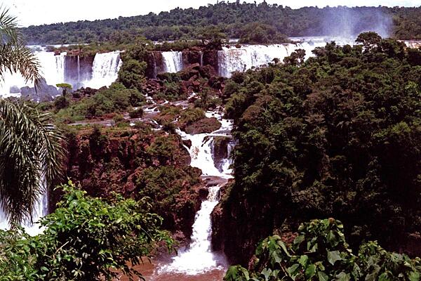
Another view of Iguazu Falls on the Brazil-Argentina border.
Another view of Iguazu Falls on the Brazil-Argentina border. • CIA World Factbook • 2020
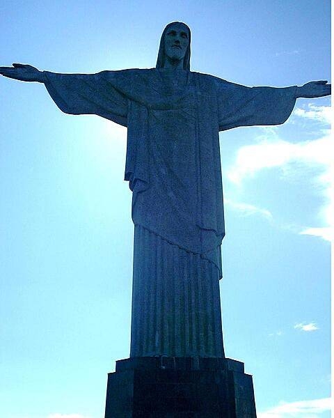
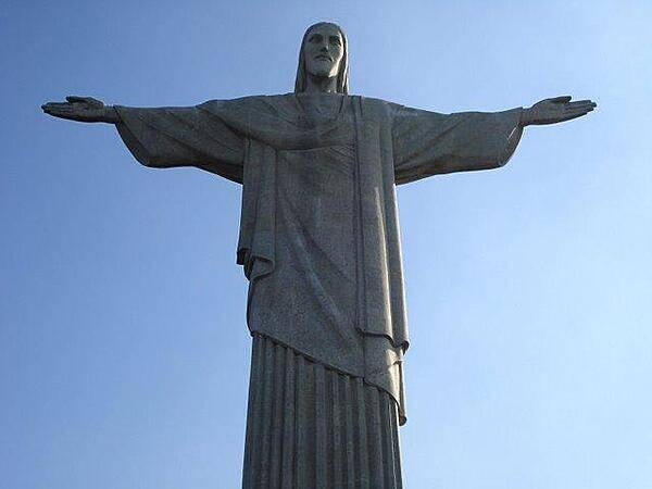
O Cristo Redentor (Christ the Redeemer) statue overlooking Rio de Janeiro. The monument, which is 38 m (120 ft) tall and stands on Corcovado Mountain, is made of reinforced concrete and soapstone. Constructed over a period of nine years, the sculpture was dedicated in 1931. In 2007, it was named one of the New Seven Wonders of the World.
O Cristo Redentor (Christ the Redeemer) statue overlooking Rio de Janeiro. The monument, which is 38 m (120 ft) tall and stands on Corcovado Mountain, is made of reinforced concrete and soapstone. Constructed over a period of nine years, the sculpture was dedicated in 1931. In 2007, it was named one of the New Seven Wonders of the World. • CIA World Factbook • 2020
Area comparison map
Area comparison map • CIA World Factbook • 2020

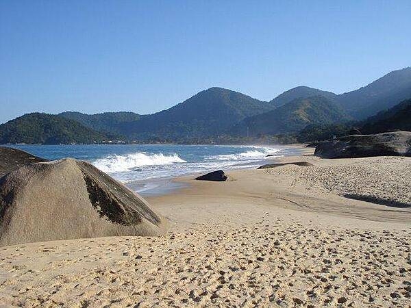
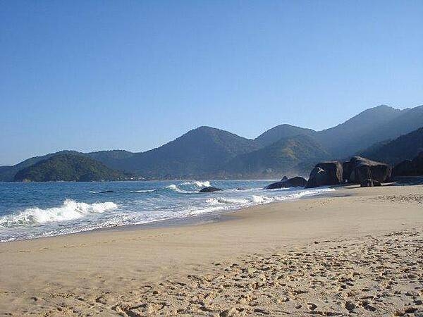
Trinidade Beach at Paraty, Rio de Janeiro state.
Trinidade Beach at Paraty, Rio de Janeiro state. • CIA World Factbook • 2020
Media source: CIA World Factbook (2020) — Public Domain