›››
Canada
Canada
Population
41.3M
Rank #37Source: World Bank
Capital
Ottawa
Source: REST Countries
Region
Americas
North America
Source: REST Countries
GDP (Nominal)
$2.24T
Rank #9Source: World Bank
Land Area
10.0M km²
Rank #2Source: REST Countries
Life Expectancy
81.647 yrs
Source: World Bank
Historical Trends
Population Trend (5-Year)
Source: World Bank
GDP Trend (5-Year, Nominal USD)
Source: World Bank
Geography
Area: 9,984,670 km²
Landlocked: No
Independent: Yes
Climate: varies from temperate in south to subarctic and arctic in north
Terrain: mostly plains with mountains in west, lowlands in southeast
Elevation: mean elevation: 487 m lowest point: Atlantic Ocean 0 m highest point: Mount Logan 5,959 m
Natural Hazards: continuous permafrost in north is a serious obstacle to development; cyclonic storms form east of the Rocky Mountains, a result of the mixing of air masses from the Arctic, Pacific, and North...
Environmental Issues: metal smelting, coal-burning utilities, and vehicle emissions impacting agricultural and forest productivity; air pollution and resulting acid rain severely affecting lakes and damaging forests;...
Land Use: agricultural land: 6.8% (2011 est.) forest: 34.1% (2011 est.) other: 59.1% (2011 est.)
Geography Note: note 1: second-largest country in world (after Russia) and largest in the Americas; strategic location between Russia and US via north polar route; approximately 90% of the population is concentrated...
Natural Resources
bauxiteiron orenickelzinccoppergoldleadrare earth elementsmolybdenumpotash
People & Society
Fertility Rate
1.26
Population
41.3M
Ethnic Groups
Canadian (32.3%)English (18.3%)Scottish (13.9%)French (13.6%)Irish (13.4%)German (9.6%)Chinese (5.1%)Italian (4.6%)North American Indian (4.4%)East Indian (4%)other 51.6%
note: percentages add up to more than (100%)
Religions
Catholic 39% (includes Roman Catholic (38.8%)other Catholic (0.2%)Protestant 20.3% (includes United Church (6.1%)Anglican (5%)Baptist (1.9%)Lutheran (1.5%)Pentecostal (1.5%)Presbyterian (1.4%)other Protestant (2.9%)Orthodox (1.6%)other Christian (6.3%)Muslim (3.2%)Hindu (1.5%)Sikh (1.4%)Buddhist (1.1%)Jewish (1%)other (0.6%)none (23.9%)
Economy
GDP per Capita
$54,340.348
GDP per Capita PPP
64,610.38
(2024)
(2024)
GNI per Capita
53,400
(2024)
(2024)
Gini Index
31.1
(2021)
(2021)
Unemployment
6.351%
(2024)
(2024)
Inflation
2.382%
(2024)
(2024)
Public Debt
64.9%
(2024)
(2024)
Energy
Electricity Access
100%
(2023)
(2023)
Renewable Energy
23.8%
(2021)
(2021)
CO₂ Emissions
577.973 Mt
(2024)
(2024)
Energy Intensity
6.44 MJ/$
(2022)
(2022)
Renewable Electricity
67.016%
(2021)
(2021)
Environment
Forest Coverage
39.462% of land
(2023)
(2023)
Communications
Internet Users
93.956%
(2023)
(2023)
Mobile Penetration
94.15%
(2023)
(2023)
Broadband Subscribers
42.524%
(2023)
(2023)
Transportation
Air Transport Freight
2,036.407 M ton-km
(2023)
(2023)
Container Port Traffic
7,010,704 TEU
(2022)
(2022)
Airports
1,078,620
Rail Lines
48,149.906 km
Roads Total
1,042,718 km(©IRF)
Military
Military Forces
Canadian Forces: Canadian Army, Royal Canadian Navy, Royal Canadian Air Force, Canadian Joint Operations Command, Canadian Special Operations Forces Command; Primary Reserve (army, air, naval...
Personnel Strength
the Canadian Armed (CAF) Forces have approximately 66,000 total active personnel (23,000 Army; 8,300 Navy; 12,000 Air Force; 23,000 other uniformed personnel)
Military Expenditure (USD)
$29.35B
Military Expenditure (% of GDP)
1.31%
Military Expenditure History
1.31% of GDP (2019 est.) 1.31% of GDP (2018) 1.44% of GDP (2017) 1.16% of GDP (2016) 1.2% of GDP (2015)
Deployments
540 Latvia (NATO); up to 200 Ukraine; up to 850 Middle East (multiple missions, including support to the Global Coalition to Defeat ISIS and NATO assistance mission Iraq; reduced considerably in 2020...
Equipment & Inventories
the CAF's inventory is a mix of domestically-produced equipment and imported weapons systems from Australia, Europe, Israel, and the US; since 2010, the leading supplier is the US; Canada's defense...
Service Age & Obligation
17 years of age for voluntary male and female military service (with parental consent); 16 years of age for Reserve and Military College applicants; Canadian citizenship or permanent residence status...
Education
Pre-Primary Enrollment
48.92%
(2020)
(2020)
Primary Enrollment
94.952%
(2023)
(2023)
Secondary Enrollment
104.288%
(2023)
(2023)
Tertiary Enrollment
76.259%
(2023)
(2023)
Education Spending
4.88% of GDP
(2022)
(2022)
Pupil-Teacher Ratio
Not Available
Health
Physicians per 1,000
2.819
(2023)
(2023)
Safe Water Access
98.29%
(2024)
(2024)
Safe Drinking Water
96.89%
(2024)
(2024)
Under-5 Mortality
5.1 per 1,000
(2023)
(2023)
Maternal Mortality (World Bank)
26.212 per 100,000
(2021)
(2021)
Hospital Beds per 1,000
83.815
(2021)
(2021)
UHC Coverage Index
92
(2023)
(2023)
Measles Immunization
92%
(2024)
(2024)
Social Indicators
Extreme Poverty Rate
0.2%
(2021)
(2021)
Food Insecurity
2.5%
(2023)
(2023)
Youth NEET Rate
13.121%
(2024)
(2024)
Governance
Women in Government
30.655%
(2024)
(2024)
Voice & Accountability
1.48
(Strong)
(2023)
(Strong)
(2023)
Political Stability
0.82
(Above Average)
(2023)
(Above Average)
(2023)
Government Effectiveness
1.52
(Strong)
(2023)
(Strong)
(2023)
Regulatory Quality
1.65
(Strong)
(2023)
(Strong)
(2023)
Rule of Law
1.47
(Strong)
(2023)
(Strong)
(2023)
Control of Corruption
1.67
(Strong)
(2023)
(Strong)
(2023)
Government
Government Type
federal parliamentary democracy (Parliament of Canada) under a constitutional monarchy; a Commonwealth realm; federal and state authorities and responsibilities regulated in constitution
Legal System
common law system except in Quebec, where civil law based on the French civil code prevails
Executive Branch
chief of state: Queen ELIZABETH II (since 6 February 1952); represented by Governor General Julie PAYETTE (since 2 October 2017) head of government: Prime Minister Justin Pierre James TRUDEAU...
Legislative Branch
description: bicameral Parliament or Parlement consists of:Senate or Senat (105 seats; members appointed by the governor general on the advice of the prime minister and can serve until age 75) House...
Judicial Branch
highest courts: Supreme Court of Canada (consists of the chief justice and 8 judges); note - in 1949, Canada abolished all appeals beyond its Supreme Court, which prior to that time, were heard by...
International Organizations
ADB (nonregional member)AfDB (nonregional member)APECArctic CouncilARFASEAN (dialogue partner)Australia GroupBIS
National Symbols
Flag Description
two vertical bands of red (hoist and fly side, half width) with white square between them; an 11-pointed red maple leaf is centered in the white square; the maple leaf has long been a Canadian symbol
National Symbols
maple leaf, beaver; national colors: red, white
National Anthem
name: O Canada lyrics/music: Adolphe-Basile ROUTHIER [French], Robert Stanley WEIR [English]/Calixa LAVALLEE note: adopted 1980; originally written in 1880, "O Canada" served as an unofficial anthem...
Safety
Homicide Rate
1.98 per 100,000
(2023)
(2023)
Travel Information
Language(s): English, French
Currency: CAD ($)
Timezone(s): UTC -03:30 to -08:00
Landlocked: No
Independent: Yes
Driving Side: Right
Calling Code: +1
Car Sign: CDN
Week Starts: Sunday
Photos
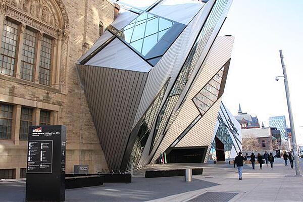
"The Crystal," the new entrance to the Royal Ontario Museum in Toronto. The ROM is Canada's largest repository of world culture and natural history.
"The Crystal," the new entrance to the Royal Ontario Museum in Toronto. The ROM is Canada's largest repository of world culture and natural history. • CIA World Factbook • 2020
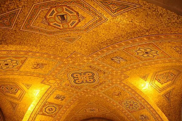
The mosaic ceiling in the rotunda of the Royal Ontario Museum in Toronto. The inscription in the middle of the dome reads: "That all men may know His work."
The mosaic ceiling in the rotunda of the Royal Ontario Museum in Toronto. The inscription in the middle of the dome reads: "That all men may know His work." • CIA World Factbook • 2020
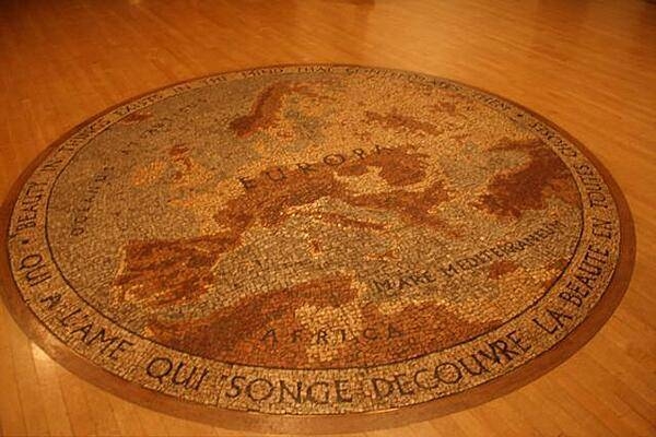
An "Old World" floor mosaic of Europe in the Royal Ontario Museum in Toronto.
An "Old World" floor mosaic of Europe in the Royal Ontario Museum in Toronto. • CIA World Factbook • 2020
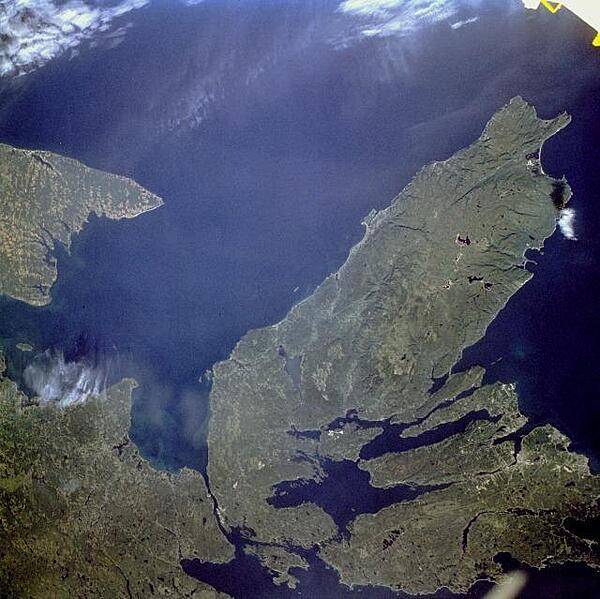
The Canadian maritime province of Nova Scotia can be divided into two separate regions - Cape Breton Island (on the right) and much larger, peninsular mainland Nova Scotia (lower left). Cape Breton Island is joined to the mainland by a causeway and a railroad spanning the narrow Strait of Canso. St. George's Bay is the small bay west of the causeway, and the Northumberland Strait separates Cape Breton Island from the eastern end of Prince Edward Island, another maritime province of Canada (visible along the west margin of the photograph). Photo courtesy of NASA.
The Canadian maritime province of Nova Scotia can be divided into two separate regions - Cape Breton Island (on the right) and much larger, peninsular mainland Nova Scotia (lower left). Cape Breton Island is joined to the mainland by a causeway and a railroad spanning the narrow Strait of Canso. St. George's Bay is the small bay west of the causeway, and the Northumberland Strait separates Cape Breton Island from the eastern end of Prince Edward Island, another maritime province of Canada (visible along the west margin of the photograph). Photo courtesy of NASA. • CIA World Factbook • 2020
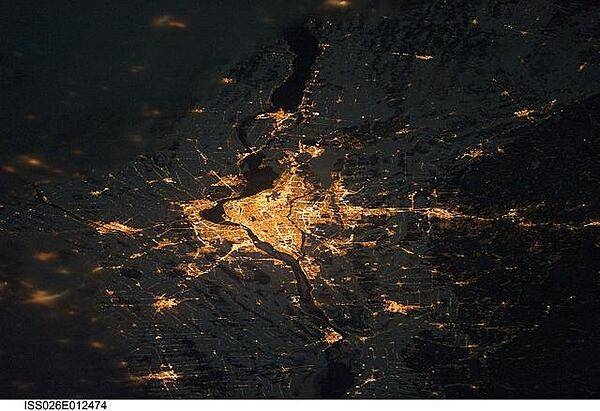
A night view of the Montreal metropolitan area is featured in this image from the International Space Station. This photo of the Montreal, Quebec metropolitan area (center) illustrates the extent of urbanization made clearly visible by city lights at night. Major roadways and industrial areas are traced by bright white lighting, while the adjacent residential and commercial land uses are characterized by more diffuse yellow-gold lighting. Rivers and other water bodies appear black, while the surrounding rural countryside is faintly illuminated by moonlight. Blurry areas at top and bottom left are caused by cloud cover. Montreal is the largest city in the dominantly French-speaking province of Quebec, and the second-largest in Canada, after Toronto. While the city of Montreal proper is located on - and almost completely covers - the Island of Montreal at the confluence of the St. Lawrence (center) and Ottawa Rivers (not visible), the city takes its name from Mont Royal located at the city's center. Image courtesy of NASA.
A night view of the Montreal metropolitan area is featured in this image from the International Space Station. This photo of the Montreal, Quebec metropolitan area (center) illustrates the extent of urbanization made clearly visible by city lights at night. Major roadways and industrial areas are traced by bright white lighting, while the adjacent residential and commercial land uses are characterized by more diffuse yellow-gold lighting. Rivers and other water bodies appear black, while the surrounding rural countryside is faintly illuminated by moonlight. Blurry areas at top and bottom left are caused by cloud cover. Montreal is the largest city in the dominantly French-speaking province of Quebec, and the second-largest in Canada, after Toronto. While the city of Montreal proper is located on - and almost completely covers - the Island of Montreal at the confluence of the St. Lawrence (center) and Ottawa Rivers (not visible), the city takes its name from Mont Royal located at the city's center. Image courtesy of NASA. • CIA World Factbook • 2020
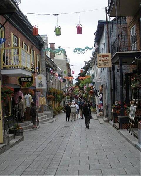
Shopping along one of Quebec City's narrow streets.
Shopping along one of Quebec City's narrow streets. • CIA World Factbook • 2020
51 photos available
View All Photos→Data sources: World Bank, UN Data • Updated daily •Learn about our data