›››
Switzerland
Switzerland
Population
9.0M
Rank #100Source: World Bank
Capital
Bern
Source: REST Countries
Region
Europe
Europe & Central Asia
Source: REST Countries
GDP (Nominal)
$936.56B
Rank #20Source: World Bank
Land Area
41.3K km²
Rank #133Source: REST Countries
Life Expectancy
84.056 yrs
Source: World Bank
Historical Trends
Population Trend (5-Year)
Source: World Bank
GDP Trend (5-Year, Nominal USD)
Source: World Bank
Geography
Area: 41,284 km²
Landlocked: Yes
Independent: Yes
Climate: temperate, but varies with altitude; cold, cloudy, rainy/snowy winters; cool to warm, cloudy, humid summers with occasional showers
Terrain: mostly mountains (Alps in south, Jura in northwest) with a central plateau of rolling hills, plains, and large lakes
Elevation: mean elevation: 1,350 m lowest point: Lake Maggiore 195 m highest point: Dufourspitze 4,634 m
Natural Hazards: avalanches, landslides; flash floods
Environmental Issues: air pollution from vehicle emissions; water pollution from agricultural fertilizers; chemical contaminants and erosion damage the soil and limit productivity; loss of biodiversity
Land Use: agricultural land: 38.7% (2011 est.) forest: 31.5% (2011 est.) other: 29.8% (2011 est.)
Geography Note: landlocked; crossroads of northern and southern Europe; along with southeastern France, northern Italy, and southwestern Austria, has the highest elevations in the Alps
Natural Resources
hydropower potentialtimbersalt
People & Society
Fertility Rate
1.33
Population
9.0M
Ethnic Groups
Swiss (69.5%)German (4.2%)Italian (3.2%)Portuguese (2.6%)French (2%)Kosovo (1.1%)other (17.3%)unspecified (0.1%)
Religions
Roman Catholic (35.9%)Protestant (23.8%)other Christian (5.9%)Muslim (5.4%)Jewish (0.3%)other (1.4%)none (26%)unspecified (1.4%)
Economy
GDP per Capita
$103,998.187
GDP per Capita PPP
96,497.695
(2024)
(2024)
GNI per Capita
95,220
(2024)
(2024)
Gini Index
33.8
(2022)
(2022)
Unemployment
4.343%
(2024)
(2024)
Inflation
1.062%
(2024)
(2024)
Public Debt
19.882%
(2023)
(2023)
Energy
Electricity Access
100%
(2023)
(2023)
Renewable Energy
27.7%
(2021)
(2021)
CO₂ Emissions
33.732 Mt
(2024)
(2024)
Energy Intensity
1.48 MJ/$
(2022)
(2022)
Renewable Electricity
68.066%
(2021)
(2021)
Environment
Forest Coverage
32.383% of land
(2023)
(2023)
Communications
Internet Users
97.344%
(2023)
(2023)
Mobile Penetration
128.64%
(2023)
(2023)
Broadband Subscribers
47.696%
(2023)
(2023)
Transportation
Air Transport Freight
1,257.504 M ton-km
(2023)
(2023)
Container Port Traffic
114,075 TEU
(2020)
(2020)
Airports
205,045
Rail Lines
4,122.251 km
Roads Total
85,009 km(©IRF)
Military
Military Forces
Swiss Armed Forces: Land Forces, Swiss Air Force (Schweizer Luftwaffe)
Personnel Strength
the Swiss Armed Forces maintain a full-time active duty cadre of about 3,000 Army and Air Force personnel along with approximately 18,500 conscripts brought in annually for 18-23 weeks of training
Military Expenditure (USD)
$6.72B
Military Expenditure (% of GDP)
0.72%
Military Expenditure History
0.7% of GDP (2019) 0.7% of GDP (2018) 0.7% of GDP (2017) 0.7% of GDP (2016) 0.7% of GDP (2015)
Deployments
165 Kosovo (NATO) (2020)
Equipment & Inventories
the Swiss Armed Forces inventory includes a mix of domestically-produced and imported weapons systems; the US is the leading supplier of military armaments to Switzerland since 2010; the Swiss...
Service Age & Obligation
18-30 years of age generally for male compulsory military service; 18 years of age for voluntary male and female military service; every Swiss male has to serve at least 245 days in the armed forces;...
Education
Pre-Primary Enrollment
102.873%
(2020)
(2020)
Primary Enrollment
102.283%
(2023)
(2023)
Secondary Enrollment
102.966%
(2023)
(2023)
Tertiary Enrollment
74.006%
(2023)
(2023)
Education Spending
4.924% of GDP
(2022)
(2022)
Pupil-Teacher Ratio
9.929:1
(2017)
(2017)
Health
Physicians per 1,000
4.477
(2022)
(2022)
Safe Water Access
100%
(2024)
(2024)
Safe Drinking Water
96.7%
(2024)
(2024)
Under-5 Mortality
3.9 per 1,000
(2023)
(2023)
Maternal Mortality (World Bank)
23.894 per 100,000
(2021)
(2021)
Hospital Beds per 1,000
83.328
(2021)
(2021)
UHC Coverage Index
87
(2023)
(2023)
Measles Immunization
96%
(2024)
(2024)
Social Indicators
Extreme Poverty Rate
0.2%
(2022)
(2022)
Food Insecurity
2.5%
(2023)
(2023)
Youth NEET Rate
8.231%
(2024)
(2024)
Governance
Women in Government
38.5%
(2024)
(2024)
Voice & Accountability
1.67
(Strong)
(2023)
(Strong)
(2023)
Political Stability
1.07
(Strong)
(2023)
(Strong)
(2023)
Government Effectiveness
2.13
(Strong)
(2023)
(Strong)
(2023)
Regulatory Quality
1.73
(Strong)
(2023)
(Strong)
(2023)
Rule of Law
1.76
(Strong)
(2023)
(Strong)
(2023)
Control of Corruption
2.02
(Strong)
(2023)
(Strong)
(2023)
Government
Government Type
federal republic (formally a confederation)
Legal System
civil law system; judicial review of legislative acts, except for federal decrees of a general obligatory character
Executive Branch
chief of state: President of the Swiss Confederation Simonetta SOMMARUGA (since 1 January 2020; Vice President Guy PARMELIN (since 1 January 2020); note - the Federal Council, which is comprised of 7...
Legislative Branch
description: description: bicameral Federal Assembly or Bundesversammlung (in German), Assemblée Fédérale (in French), Assemblea Federale (in Italian) consists of:Council of States or Ständerat (in...
Judicial Branch
highest courts: Federal Supreme Court (consists of 38 justices and 19 deputy justices organized into 7 divisions) judge selection and term of office: judges elected by the Federal Assembly for 6-year...
International Organizations
National Symbols
Flag Description
red square with a bold, equilateral white cross in the center that does not extend to the edges of the flag; various medieval legends purport to describe the origin of the flag; a white cross used as...
National Symbols
Swiss cross (white cross on red field, arms equal length); national colors: red, white
National Anthem
Leonhard WIDMER [German], Charles CHATELANAT [French], Camillo VALSANGIACOMO [Italian], and Flurin CAMATHIAS [Romansch]/Alberik ZWYSSIG the Swiss anthem has four names: "Schweizerpsalm" [German]...
Safety
Homicide Rate
0.597 per 100,000
(2023)
(2023)
Travel Information
Language(s): French, Swiss German, Italian, +1 more
Currency: CHF (Fr.)
Timezone(s): UTC+01:00
Landlocked: Yes
Independent: Yes
Driving Side: Right
Calling Code: +41
Car Sign: CH
Week Starts: Monday
Photos
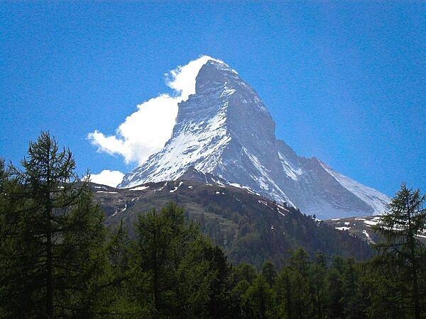
The Matterhorn is a pyramidal mountain on the border between Switzerland and Italy. Its summit is 4,478 m (14,692 ft) high, making it one of the highest, most famous, and deadliest peaks in the Alps. The steep faces, oriented to each compass point, cause regular avalanches; the snow that builds up around the base forms glaciers. Mountains around the world with similar profiles frequently earn "Matterhorn" as a nickname because of the mountain's iconic shape.
The Matterhorn is a pyramidal mountain on the border between Switzerland and Italy. Its summit is 4,478 m (14,692 ft) high, making it one of the highest, most famous, and deadliest peaks in the Alps. The steep faces, oriented to each compass point, cause regular avalanches; the snow that builds up around the base forms glaciers. Mountains around the world with similar profiles frequently earn "Matterhorn" as a nickname because of the mountain's iconic shape. • CIA World Factbook • 2020
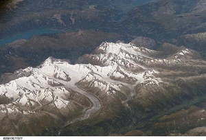
Three of the higher peaks of the Bernese Alps are visible -Jungfrau (4,158 m), Moench (4,089 m), and Eiger (3,970 m). To the east and south of the Jungfrau is the Aletsch Glacier, clearly marked by dark medial moraines extending along the glacier's length parallel to the valley axis. Moraines are formed from rock and soil debris scoured along the sides of mountain glaciers that gradually accumulate in the middle of the glacier and are carried along the flow direction. Lake Brienz to the northwest is glacially carved. Image courtesy of NASA.
Three of the higher peaks of the Bernese Alps are visible -Jungfrau (4,158 m), Moench (4,089 m), and Eiger (3,970 m). To the east and south of the Jungfrau is the Aletsch Glacier, clearly marked by dark medial moraines extending along the glacier's length parallel to the valley axis. Moraines are formed from rock and soil debris scoured along the sides of mountain glaciers that gradually accumulate in the middle of the glacier and are carried along the flow direction. Lake Brienz to the northwest is glacially carved. Image courtesy of NASA. • CIA World Factbook • 2020
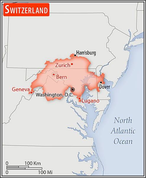
Area comparison map
Area comparison map • CIA World Factbook • 2020
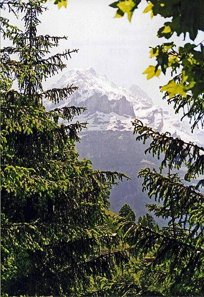
The Swiss Alps enfold a verdant valley.
The Swiss Alps enfold a verdant valley. • CIA World Factbook • 2020
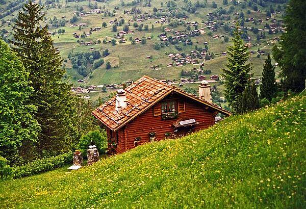
House overlooking an Alpine valley.
House overlooking an Alpine valley. • CIA World Factbook • 2020
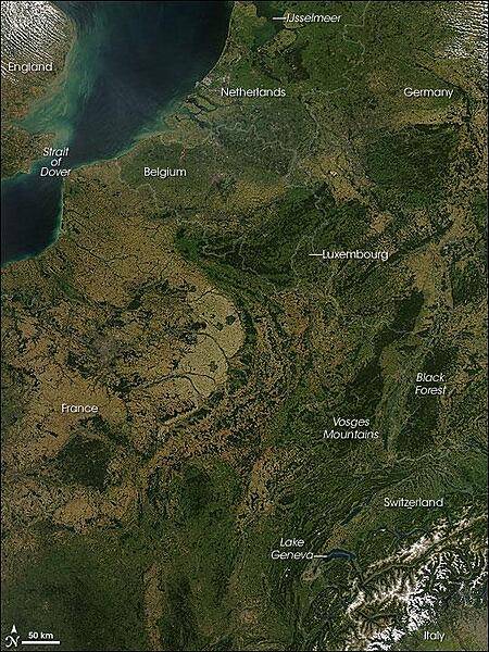
A rare cloud-free view of a wide area of Western Europe. This Aqua satellite image was captured on 30 August 2008. Skies were clear from the Netherlands in the north to Italy in the south, revealing several of Europe's famous natural and man-made features. A few small fires (marked with red dots) were detected, as well. A pair of geologically matching mountain ranges appear at the border of France and Germany, covered in dark green forests. France's Vosges and Germany's Black Forest rise on either side of the Rhine River Valley. The valley in that area is known to geologists as the Rhine Graben; a graben is an elongated block of Earth's crust that has sunk relative to surrounding blocks. To the south, the snow-covered Alps create an arcing boundary between Switzerland and Italy. Near the bottom right of the image, one of the largest lakes in Europe, Lake Geneva (formally known as Lac Leman), fills a glacier-carved valley in western Switzerland. This natural lake occurs on the Rhone River, upstream of where it makes a sharp southward bend as it leaves the Alps. At the northern edge of the image is a larger, artificial lake: the Netherland's IJsselmeer. Despite its closeness to the North Sea, IJsselmeer is a freshwater lake. It was originally a saltwater inlet at the mouth of the IJssel River, but in the early 1930s, the Dutch built a dike across the inlet. The freshwater flow of the IJssel River flushed out the seawater, forming the new lake. Photo courtesy of NASA.
A rare cloud-free view of a wide area of Western Europe. This Aqua satellite image was captured on 30 August 2008. Skies were clear from the Netherlands in the north to Italy in the south, revealing several of Europe's famous natural and man-made features. A few small fires (marked with red dots) were detected, as well.
A pair of geologically matching mountain ranges appear at the border of France and Germany, covered in dark green forests. France's Vosges and Germany's Black Forest rise on either side of the Rhine River Valley. The valley in that area is known to geologists as the Rhine Graben; a graben is an elongated block of Earth's crust that has sunk relative to surrounding blocks. To the south, the snow-covered Alps create an arcing boundary between Switzerland and Italy.
Near the bottom right of the image, one of the largest lakes in Europe, Lake Geneva (formally known as Lac Leman), fills a glacier-carved valley in western Switzerland. This natural lake occurs on the Rhone River, upstream of where it makes a sharp southward bend as it leaves the Alps. At the northern edge of the image is a larger, artificial lake: the Netherland's IJsselmeer. Despite its closeness to the North Sea, IJsselmeer is a freshwater lake. It was originally a saltwater inlet at the mouth of the IJssel River, but in the early 1930s, the Dutch built a dike across the inlet. The freshwater flow of the IJssel River flushed out the seawater, forming the new lake. Photo courtesy of NASA. • CIA World Factbook • 2020
21 photos available
View All Photos→Data sources: World Bank, UN Data • Updated daily •Learn about our data