›››
Switzerland — Media Gallery
21 items available (flags, maps, photos)
Photos
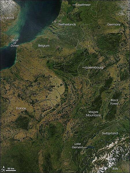
A rare cloud-free view of a wide area of Western Europe. This Aqua satellite image was captured on 30 August 2008. Skies were clear from the Netherlands in the north to Italy in the south, revealing several of Europe's famous natural and man-made features. A few small fires (marked with red dots) were detected, as well. A pair of geologically matching mountain ranges appear at the border of France and Germany, covered in dark green forests. France's Vosges and Germany's Black Forest rise on either side of the Rhine River Valley. The valley in that area is known to geologists as the Rhine Graben; a graben is an elongated block of Earth's crust that has sunk relative to surrounding blocks. To the south, the snow-covered Alps create an arcing boundary between Switzerland and Italy. Near the bottom right of the image, one of the largest lakes in Europe, Lake Geneva (formally known as Lac Leman), fills a glacier-carved valley in western Switzerland. This natural lake occurs on the Rhone River, upstream of where it makes a sharp southward bend as it leaves the Alps. At the northern edge of the image is a larger, artificial lake: the Netherland's IJsselmeer. Despite its closeness to the North Sea, IJsselmeer is a freshwater lake. It was originally a saltwater inlet at the mouth of the IJssel River, but in the early 1930s, the Dutch built a dike across the inlet. The freshwater flow of the IJssel River flushed out the seawater, forming the new lake. Photo courtesy of NASA.
A rare cloud-free view of a wide area of Western Europe. This Aqua satellite image was captured on 30 August 2008. Skies were clear from the Netherlands in the north to Italy in the south, revealing several of Europe's famous natural and man-made features. A few small fires (marked with red dots) were detected, as well.
A pair of geologically matching mountain ranges appear at the border of France and Germany, covered in dark green forests. France's Vosges and Germany's Black Forest rise on either side of the Rhine River Valley. The valley in that area is known to geologists as the Rhine Graben; a graben is an elongated block of Earth's crust that has sunk relative to surrounding blocks. To the south, the snow-covered Alps create an arcing boundary between Switzerland and Italy.
Near the bottom right of the image, one of the largest lakes in Europe, Lake Geneva (formally known as Lac Leman), fills a glacier-carved valley in western Switzerland. This natural lake occurs on the Rhone River, upstream of where it makes a sharp southward bend as it leaves the Alps. At the northern edge of the image is a larger, artificial lake: the Netherland's IJsselmeer. Despite its closeness to the North Sea, IJsselmeer is a freshwater lake. It was originally a saltwater inlet at the mouth of the IJssel River, but in the early 1930s, the Dutch built a dike across the inlet. The freshwater flow of the IJssel River flushed out the seawater, forming the new lake. Photo courtesy of NASA. • CIA World Factbook • 2020
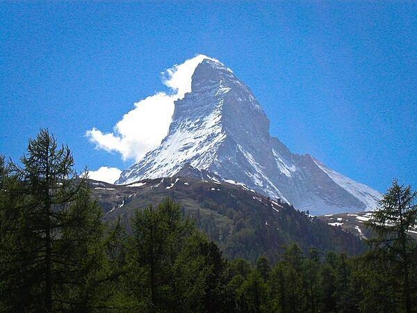
The Matterhorn is a pyramidal mountain on the border between Switzerland and Italy. Its summit is 4,478 m (14,692 ft) high, making it one of the highest, most famous, and deadliest peaks in the Alps. The steep faces, oriented to each compass point, cause regular avalanches; the snow that builds up around the base forms glaciers. Mountains around the world with similar profiles frequently earn "Matterhorn" as a nickname because of the mountain's iconic shape.
The Matterhorn is a pyramidal mountain on the border between Switzerland and Italy. Its summit is 4,478 m (14,692 ft) high, making it one of the highest, most famous, and deadliest peaks in the Alps. The steep faces, oriented to each compass point, cause regular avalanches; the snow that builds up around the base forms glaciers. Mountains around the world with similar profiles frequently earn "Matterhorn" as a nickname because of the mountain's iconic shape. • CIA World Factbook • 2020
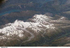
Three of the higher peaks of the Bernese Alps are visible -Jungfrau (4,158 m), Moench (4,089 m), and Eiger (3,970 m). To the east and south of the Jungfrau is the Aletsch Glacier, clearly marked by dark medial moraines extending along the glacier's length parallel to the valley axis. Moraines are formed from rock and soil debris scoured along the sides of mountain glaciers that gradually accumulate in the middle of the glacier and are carried along the flow direction. Lake Brienz to the northwest is glacially carved. Image courtesy of NASA.
Three of the higher peaks of the Bernese Alps are visible -Jungfrau (4,158 m), Moench (4,089 m), and Eiger (3,970 m). To the east and south of the Jungfrau is the Aletsch Glacier, clearly marked by dark medial moraines extending along the glacier's length parallel to the valley axis. Moraines are formed from rock and soil debris scoured along the sides of mountain glaciers that gradually accumulate in the middle of the glacier and are carried along the flow direction. Lake Brienz to the northwest is glacially carved. Image courtesy of NASA. • CIA World Factbook • 2020
Area comparison map
Area comparison map • CIA World Factbook • 2020
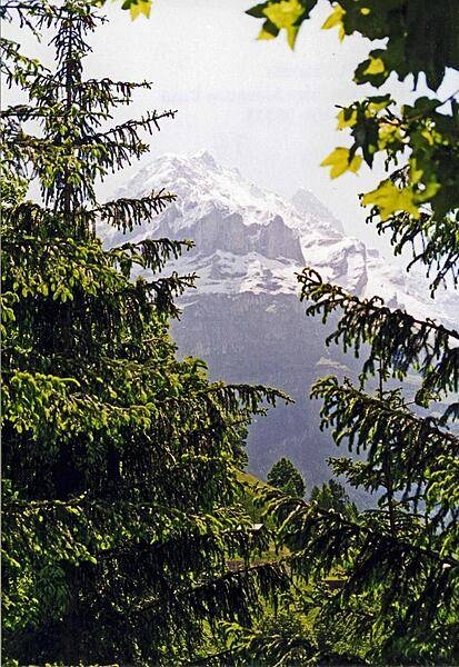
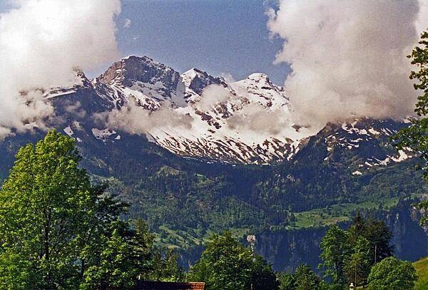
The Swiss Alps enfold a verdant valley.
The Swiss Alps enfold a verdant valley. • CIA World Factbook • 2020
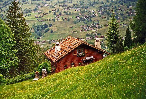
House overlooking an Alpine valley.
House overlooking an Alpine valley. • CIA World Factbook • 2020
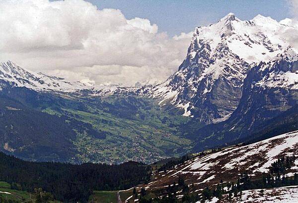
Mount Wetterhorn (3,692 m; 12,110 ft), near Grindelwald, overlooks the upper reaches of an Alpine valley - still snow covered in June.
Mount Wetterhorn (3,692 m; 12,110 ft), near Grindelwald, overlooks the upper reaches of an Alpine valley - still snow covered in June. • CIA World Factbook • 2020
The Principality of Liechtenstein is a landlocked alpine country between Austria and Switzerland; it has an area of 160 sq km (61 sq mi). Despite its limited natural resources, Liechtenstein is one of the few countries in the world with more registered companies than citizens. The image was acquired 21 May 2007 and covers an area of about 19 x 28 km. Photo courtesy of NASA.
The Principality of Liechtenstein is a landlocked alpine country between Austria and Switzerland; it has an area of 160 sq km (61 sq mi). Despite its limited natural resources, Liechtenstein is one of the few countries in the world with more registered companies than citizens. The image was acquired 21 May 2007 and covers an area of about 19 x 28 km. Photo courtesy of NASA. • CIA World Factbook • 2020
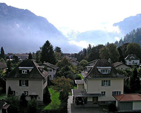
Sturdily built Swiss homes lie in the shadows of some imposing mountains.
Sturdily built Swiss homes lie in the shadows of some imposing mountains. • CIA World Factbook • 2020
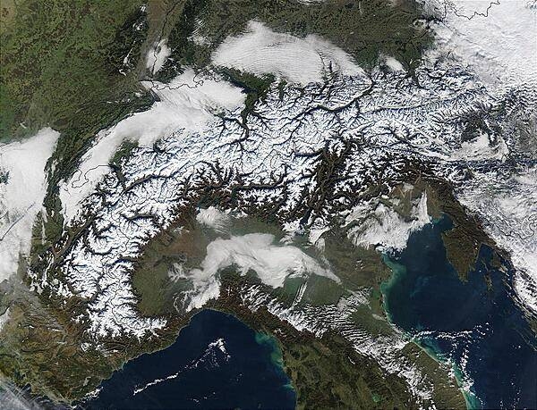
The Alps march across this image of Autumnal (early October) southern Europe. On either side of and above the Alps are the countries of (from left to right) France, Switzerland, Liechtenstein, Austria, and Slovenia, while below the Alps is Italy. The Mediterranean and Ligurian Seas sit to the west of Italy, while to the right is the Adriatic Sea. As the season progresses, snow begins to whiten the Alps. Image courtesy of NASA.
The Alps march across this image of Autumnal (early October) southern Europe. On either side of and above the Alps are the countries of (from left to right) France, Switzerland, Liechtenstein, Austria, and Slovenia, while below the Alps is Italy. The Mediterranean and Ligurian Seas sit to the west of Italy, while to the right is the Adriatic Sea. As the season progresses, snow begins to whiten the Alps. Image courtesy of NASA. • CIA World Factbook • 2020
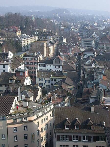
Aerial view of Zurich.
Aerial view of Zurich. • CIA World Factbook • 2020
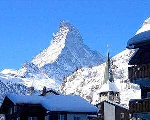
The Matterhorn towers over the roofs of Zermatt; at 4,478 m (14,688 ft), is one of the highest peaks in the Alps.
The Matterhorn towers over the roofs of Zermatt; at 4,478 m (14,688 ft), is one of the highest peaks in the Alps. • CIA World Factbook • 2020
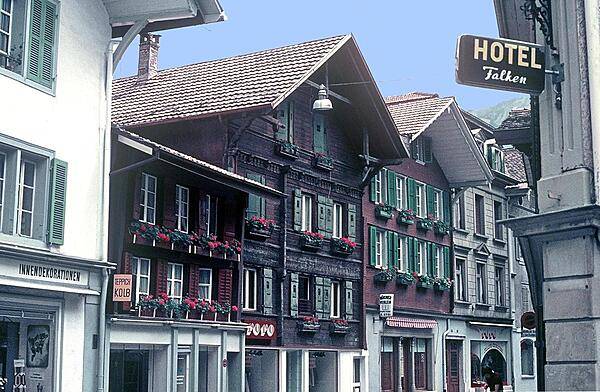
A charming street scene in Interlaken, Bern canton.
A charming street scene in Interlaken, Bern canton. • CIA World Factbook • 2020
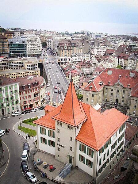
Overlooking the Mudac Museum for Contemporary Applied Arts in Lausanne. The Mudac opened in 2000 replacing the Museum for Decorative Arts.
Overlooking the Mudac Museum for Contemporary Applied Arts in Lausanne. The Mudac opened in 2000 replacing the Museum for Decorative Arts. • CIA World Factbook • 2020
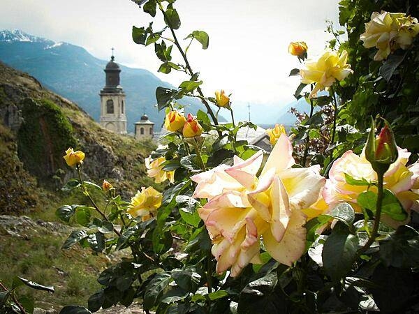
Rosebuds reach for the heavens near a church in the valley town of Sion.
Rosebuds reach for the heavens near a church in the valley town of Sion. • CIA World Factbook • 2020
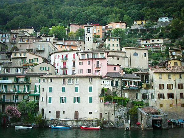
Lake Lugano is a glacial lake at the border between Switzerland and Italy. At 49 sq km (19 sq mi) and an average width of approximately one kilometer (over half a mile), roughly 60% of the lake lies in Switzerland, the rest in Italy.
Lake Lugano is a glacial lake at the border between Switzerland and Italy. At 49 sq km (19 sq mi) and an average width of approximately one kilometer (over half a mile), roughly 60% of the lake lies in Switzerland, the rest in Italy. • CIA World Factbook • 2020
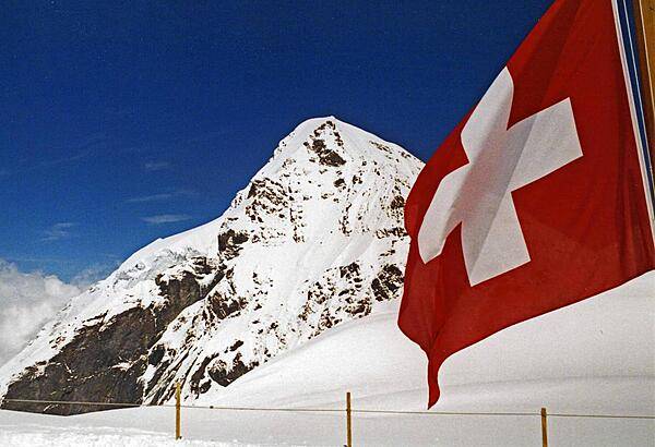
The Swiss flag against a field of snow.
The Swiss flag against a field of snow. • CIA World Factbook • 2020
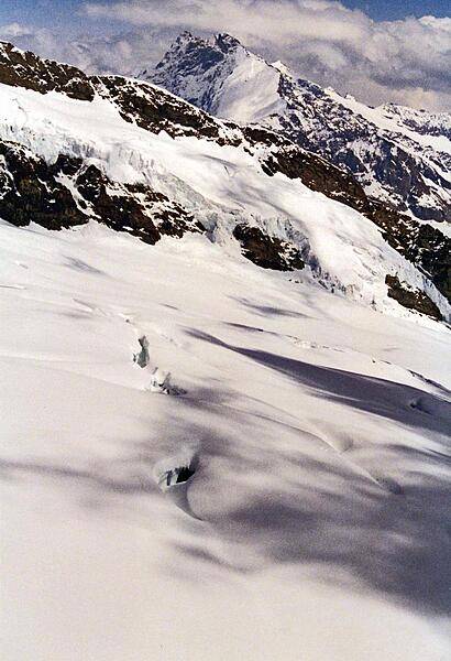
Snow, rocks, shadows, and peaks merge upward into the clouds.
Snow, rocks, shadows, and peaks merge upward into the clouds. • CIA World Factbook • 2020
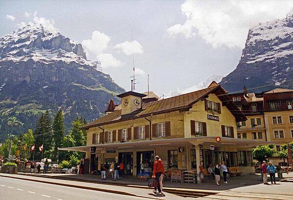
The train station in Grindelwald on a sunny day. Located in the canton of Bern, this agricultural community lies 1,034 m (3,392 ft) above sea level, and attracts tourists for hiking in the summer and skiing in the winter.
The train station in Grindelwald on a sunny day. Located in the canton of Bern, this agricultural community lies 1,034 m (3,392 ft) above sea level, and attracts tourists for hiking in the summer and skiing in the winter. • CIA World Factbook • 2020
Towering peaks peer through some low-sailing clouds.
Towering peaks peer through some low-sailing clouds. • CIA World Factbook • 2020
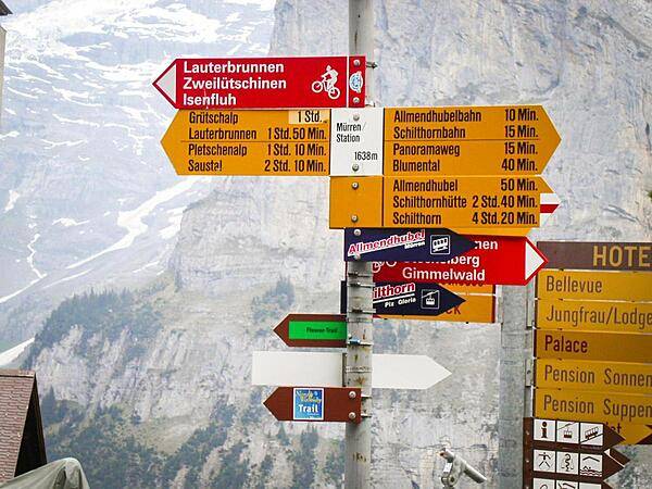
Way signs in Murren, a traditional mountain village in Bernese Oberland, unreachable by public road. The village features a view of the three towering mountains: Eiger, Monch, and Jungfrau. At an elevation of 1,650 m (5,413 ft), access to the village is via four cable cars known as Luftseilbahn-Stechelberg-Murren-Schilthorn (LSMS), which also provide access to the summit of Schilthorn, the location of a rotating restaurant with spectacular views.
Way signs in Murren, a traditional mountain village in Bernese Oberland, unreachable by public road. The village features a view of the three towering mountains: Eiger, Monch, and Jungfrau. At an elevation of 1,650 m (5,413 ft), access to the village is via four cable cars known as Luftseilbahn-Stechelberg-Murren-Schilthorn (LSMS), which also provide access to the summit of Schilthorn, the location of a rotating restaurant with spectacular views. • CIA World Factbook • 2020
Media source: CIA World Factbook (2020) — Public Domain