›››
Chile
Chile
Population
19.8M
Rank #65Source: World Bank
Capital
Santiago
Source: REST Countries
Region
Americas
Latin America & Caribbean
Source: REST Countries
GDP (Nominal)
$330.27B
Rank #45Source: World Bank
Land Area
756.1K km²
Rank #38Source: REST Countries
Life Expectancy
81.167 yrs
Source: World Bank
Historical Trends
Population Trend (5-Year)
Source: World Bank
GDP Trend (5-Year, Nominal USD)
Source: World Bank
Geography
Area: 756,102 km²
Landlocked: No
Independent: Yes
Climate: temperate; desert in north; Mediterranean in central region; cool and damp in south
Terrain: low coastal mountains, fertile central valley, rugged Andes in east
Elevation: mean elevation: 1,871 m lowest point: Pacific Ocean 0 m highest point: Nevado Ojos del Salado 6,880 m
Natural Hazards: severe earthquakes; active volcanism; tsunamisvolcanism: significant volcanic activity due to more than three-dozen active volcanoes along the Andes Mountains; Lascar (5,592 m), which last erupted in...
Environmental Issues: air pollution from industrial and vehicle emissions; water pollution from raw sewage; noise pollution; improper garbage disposal; soil degradation; widespread deforestation and mining threaten the...
Land Use: agricultural land: 21.1% (2011 est.) forest: 21.9% (2011 est.) other: 57% (2011 est.)
Geography Note: note 1: the longest north-south trending country in the world, extending across 39 degrees of latitude; strategic location relative to sea lanes between the Atlantic and Pacific Oceans (Strait of...
Natural Resources
coppertimberiron orenitratesprecious metalsmolybdenumhydropower
People & Society
Fertility Rate
1.17
Population
19.8M
Ethnic Groups
White and non-indigenous (88.9%)Mapuche (9.1%)Aymara (0.7%)other indigenous groups (1%)unspecified (0.3%)
Religions
Roman Catholic (66.7%)Evangelical or Protestant (16.4%)Jehovah's Witness (1%)other (3.4%)none (11.5%)unspecified (1.1%)
Economy
GDP per Capita
$16,709.889
GDP per Capita PPP
36,181.157
(2024)
(2024)
GNI per Capita
15,750
(2024)
(2024)
Gini Index
43
(2022)
(2022)
Unemployment
8.718%
(2024)
(2024)
Inflation
4.298%
(2024)
(2024)
Public Debt
Not Available
Energy
Electricity Access
100%
(2023)
(2023)
Renewable Energy
24.2%
(2021)
(2021)
CO₂ Emissions
77.823 Mt
(2024)
(2024)
Energy Intensity
3.19 MJ/$
(2022)
(2022)
Renewable Electricity
48.082%
(2021)
(2021)
Environment
Forest Coverage
25.012% of land
(2023)
(2023)
Communications
Internet Users
94.457%
(2023)
(2023)
Mobile Penetration
135.871%
(2023)
(2023)
Broadband Subscribers
22.995%
(2023)
(2023)
Transportation
Air Transport Freight
1,499.035 M ton-km
(2023)
(2023)
Container Port Traffic
4,158,260 TEU
(2022)
(2022)
Airports
144,494
Rail Lines
2,396 km
Roads Total
85,709.32 km(©IRF)
Military
Military Forces
Armed Forces of Chile (Fuerzas Armadas de Chile): Chilean Army, Chilean Navy (Armada de Chile, includes Naval Aviation, Marine Corps, and Maritime Territory and Merchant Marine Directorate...
Personnel Strength
the Armed Forces of Chile have approximately 80,000 active personnel (45,000 Army; 22,000 Navy; 13,000 Air Force); approximately 45,000 Carabineros
Military Expenditure (USD)
$5.11B
Military Expenditure (% of GDP)
1.58%
Military Expenditure History
1.8% of GDP (2019) 1.9% of GDP (2018) 1.9% of GDP (2017) 1.9% of GDP (2016) 1.9% of GDP (2015)
Equipment & Inventories
the Chilean military inventory is comprised of a mix of mostly European and US equipment and a limited number of domestically-produced systems; since 2010, France, Germany, the Netherlands, and the...
Service Age & Obligation
18-45 years of age for voluntary male and female military service, although the right to compulsory recruitment of males 18-45 is retained; service obligation is 12 months for Army and 22 months for...
Education
Pre-Primary Enrollment
84.511%
(2020)
(2020)
Primary Enrollment
100.318%
(2023)
(2023)
Secondary Enrollment
105.831%
(2023)
(2023)
Tertiary Enrollment
104.734%
(2023)
(2023)
Education Spending
4.898% of GDP
(2022)
(2022)
Adult Literacy Rate
96.4%
(2017)
(2017)
Pupil-Teacher Ratio
17.794:1
(2017)
(2017)
Health
Physicians per 1,000
3.334
(2023)
(2023)
Safe Water Access
99.081%
(2024)
(2024)
Safe Drinking Water
97.817%
(2024)
(2024)
Under-5 Mortality
7.2 per 1,000
(2023)
(2023)
Maternal Mortality (World Bank)
21.507 per 100,000
(2021)
(2021)
Hospital Beds per 1,000
76.69
(2021)
(2021)
UHC Coverage Index
84
(2023)
(2023)
Measles Immunization
95%
(2024)
(2024)
Social Indicators
Extreme Poverty Rate
0.5%
(2022)
(2022)
Food Insecurity
2.5%
(2023)
(2023)
Youth NEET Rate
21.054%
(2024)
(2024)
Governance
Women in Government
35.484%
(2024)
(2024)
Voice & Accountability
1.02
(Strong)
(2023)
(Strong)
(2023)
Political Stability
0.14
(Above Average)
(2023)
(Above Average)
(2023)
Government Effectiveness
0.72
(Above Average)
(2023)
(Above Average)
(2023)
Regulatory Quality
0.93
(Above Average)
(2023)
(Above Average)
(2023)
Rule of Law
0.63
(Above Average)
(2023)
(Above Average)
(2023)
Control of Corruption
0.97
(Above Average)
(2023)
(Above Average)
(2023)
Government
Government Type
presidential republic
Legal System
civil law system influenced by several West European civil legal systems; judicial review of legislative acts by the Constitutional Tribunal
Executive Branch
chief of state: President Sebastian PINERA Echenique (since 11 March 2018); note - the president is both chief of state and head of government head of government: President Sebastian PINERA Echenique...
Legislative Branch
description: bicameral National Congress or Congreso Nacional consists of:Senate or Senado (43 seats following the 2017 election; to increase to 50 in 2021); members directly elected in multi-seat...
Judicial Branch
highest courts: Supreme Court or Corte Suprema (consists of a court president and 20 members or ministros); Constitutional Court (consists of 10 members); Elections Qualifying Court (consists of 5...
National Symbols
Flag Description
two equal horizontal bands of white (top) and red; a blue square the same height as the white band at the hoist-side end of the white band; the square bears a white five-pointed star in the center...
National Symbols
huemul (mountain deer), Andean condor; national colors: red, white, blue
National Anthem
name: "Himno Nacional de Chile" (National Anthem of Chile) lyrics/music: Eusebio LILLO Robles and Bernardo DE VERA y Pintado/Ramon CARNICER y Battle note: music adopted 1828, original lyrics adopted...
Safety
Homicide Rate
6.348 per 100,000
(2023)
(2023)
Travel Information
Language(s): Spanish
Currency: CLP ($)
Timezone(s): UTC -04:00 to -06:00
Landlocked: No
Independent: Yes
Driving Side: Right
Calling Code: +56
Car Sign: RCH
Week Starts: Monday
Photos

Easter Island, one of the most remote locations on Earth, is more than 3,200 km (2,000 mi) from the closest populations on Tahiti or Chile. Less than 25 km (15 mi) long, the island is dominated by volcanic landforms, including the large crater Rana Kao at the southwest end of the island and a line of cinder cones that stretch north from the central mountain. A final feature (difficult to see) is the very long runway (Chile's longest) near Rana Kao. The airport serves as an emergency space shuttle landing site. Image courtesy of NASA.
Easter Island, one of the most remote locations on Earth, is more than 3,200 km (2,000 mi) from the closest populations on Tahiti or Chile. Less than 25 km (15 mi) long, the island is dominated by volcanic landforms, including the large crater Rana Kao at the southwest end of the island and a line of cinder cones that stretch north from the central mountain. A final feature (difficult to see) is the very long runway (Chile's longest) near Rana Kao. The airport serves as an emergency space shuttle landing site. Image courtesy of NASA. • CIA World Factbook • 2020
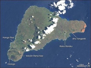
Discovered by Dutch sailors on Easter Sunday 1722 and named for the holy day, the isolated Pacific island had already been inhabited for more than one thousand years, most likely settled by Polynesian sailors in canoes between A.D. 400 and 700. The most amazing cultural artifacts on display were giant stone statues, called moai, resting on ahu, raised platforms of expertly fitted stones. Most of the hundreds of moai on the island were carved out of volcanic rock in the crater of Rano Raraku, located in the southeastern part of the island. In addition to the many moai scattered around the coast of the island, Rano Raraku is littered with moai, some only half-carved, others that appear to have broken in the attempt to remove them from the quarry, and still others that seem to simply have been abandoned. East of Rano Raraku is Ahu Tongariki, where in 1960 a tidal wave caused by an earthquake in Chile struck the southern coastline and swept 15 moai inland for several hundred feet. In 1992, the site was restored by a Chilean archeologist. On the western end of the island is the only town, Hanga Roa, where most of Rapa Nui's 2,000 residents live. South of the town is the island's largest volcanic crater, Rana Kao. Along the crater rim looking southward over the coast, lie the ruins of Orongo, a ceremonial site containing elaborate stone carvings and other artwork. Landsat image courtesy of NASA.
Discovered by Dutch sailors on Easter Sunday 1722 and named for the holy day, the isolated Pacific island had already been inhabited for more than one thousand years, most likely settled by Polynesian sailors in canoes between A.D. 400 and 700. The most amazing cultural artifacts on display were giant stone statues, called moai, resting on ahu, raised platforms of expertly fitted stones. Most of the hundreds of moai on the island were carved out of volcanic rock in the crater of Rano Raraku, located in the southeastern part of the island. In addition to the many moai scattered around the coast of the island, Rano Raraku is littered with moai, some only half-carved, others that appear to have broken in the attempt to remove them from the quarry, and still others that seem to simply have been abandoned. East of Rano Raraku is Ahu Tongariki, where in 1960 a tidal wave caused by an earthquake in Chile struck the southern coastline and swept 15 moai inland for several hundred feet. In 1992, the site was restored by a Chilean archeologist. On the western end of the island is the only town, Hanga Roa, where most of Rapa Nui's 2,000 residents live. South of the town is the island's largest volcanic crater, Rana Kao. Along the crater rim looking southward over the coast, lie the ruins of Orongo, a ceremonial site containing elaborate stone carvings and other artwork. Landsat image courtesy of NASA. • CIA World Factbook • 2020
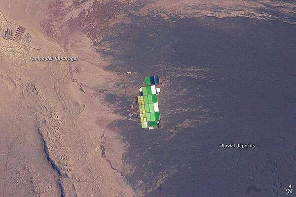
Brightly colored solar evaporation (salt) ponds in a desert landscape give this astronaut photo an unreal quality. The ponds sit near the foot of a long alluvial fan in the Pampa del Tamarugal, the great hyper-arid inner valley of Chile's Atacama Desert. The alluvial fan sediments are dark brown, and they contrast sharply with tan sediments of the Pampa del Tamarugal. Nitrates and many other minerals are mined in this region. A few extraction pits and ore dumps are visible at upper left. Iodine is one of the products from mining; it is first extracted by heap leaching. Waste liquids from the iodine plants are dried in the tan and brightly colored evaporation ponds to crystallize nitrate salts for collection. The recovered nitrates are mainly used for fertilizer for higher-value crops. They are also used in the manufacture of pharmaceuticals, explosives, glass, and ceramics, as well as in water treatment and metallurgical processes. Image courtesy of NASA.
Brightly colored solar evaporation (salt) ponds in a desert landscape give this astronaut photo an unreal quality. The ponds sit near the foot of a long alluvial fan in the Pampa del Tamarugal, the great hyper-arid inner valley of Chile's Atacama Desert. The alluvial fan sediments are dark brown, and they contrast sharply with tan sediments of the Pampa del Tamarugal.
Nitrates and many other minerals are mined in this region. A few extraction pits and ore dumps are visible at upper left. Iodine is one of the products from mining; it is first extracted by heap leaching. Waste liquids from the iodine plants are dried in the tan and brightly colored evaporation ponds to crystallize nitrate salts for collection. The recovered nitrates are mainly used for fertilizer for higher-value crops. They are also used in the manufacture of pharmaceuticals, explosives, glass, and ceramics, as well as in water treatment and metallurgical processes. Image courtesy of NASA. • CIA World Factbook • 2020
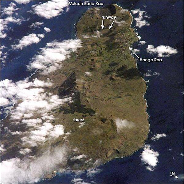
View of Easter Island from space. The island is one of the most remote locations on Earth, being more than 3,200 km (2,000 mi) from the closest populations on Tahiti or Chile. The island is perhaps most famous for the giant stone monoliths, known as moai, that have been placed along the coastline. Archaeologists believe the island was discovered and colonized by Polynesians sometime between A.D. 400 and 700. Subsequently, a unique culture developed. The human population grew to levels that could not be sustained by the island. A civil war resulted, and the island's deforestation and ecosystem collapse was nearly complete. Today, a new forest (primarily eucalyptus) has been established in the center of the island (dark green). Less than 25 km (15 mi) long, the geography of the island is dominated by volcanic landforms, including the large crater Rana Kao at the southwest end of the island and a line of cinder cones that stretch north from the central mountain. A final feature (difficult to see) is the very long runway (Chile's longest) near Rana Kao, which served (but was never used) as an emergency landing site for the Space Shuttle. Image courtesy of NASA.
View of Easter Island from space. The island is one of the most remote locations on Earth, being more than 3,200 km (2,000 mi) from the closest populations on Tahiti or Chile. The island is perhaps most famous for the giant stone monoliths, known as moai, that have been placed along the coastline. Archaeologists believe the island was discovered and colonized by Polynesians sometime between A.D. 400 and 700. Subsequently, a unique culture developed. The human population grew to levels that could not be sustained by the island. A civil war resulted, and the island's deforestation and ecosystem collapse was nearly complete. Today, a new forest (primarily eucalyptus) has been established in the center of the island (dark green). Less than 25 km (15 mi) long, the geography of the island is dominated by volcanic landforms, including the large crater Rana Kao at the southwest end of the island and a line of cinder cones that stretch north from the central mountain. A final feature (difficult to see) is the very long runway (Chile's longest) near Rana Kao, which served (but was never used) as an emergency landing site for the Space Shuttle. Image courtesy of NASA. • CIA World Factbook • 2020
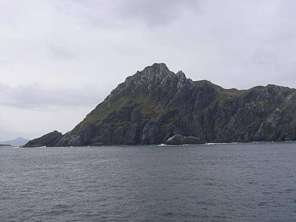
Cape Horn, named after a city in the Netherlands, is the southernmost headland of the Tierra del Fuego archipelago in southern Chile. It is frequently referred to as the "sailors' graveyard" because the waters around the area are particularly hazardous due to strong winds, large waves, strong currents, and icebergs.
Cape Horn, named after a city in the Netherlands, is the southernmost headland of the Tierra del Fuego archipelago in southern Chile. It is frequently referred to as the "sailors' graveyard" because the waters around the area are particularly hazardous due to strong winds, large waves, strong currents, and icebergs. • CIA World Factbook • 2020
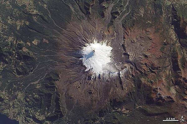
Near the southern tip of South America, a trio of volcanoes lines up perpendicular to the Andes Mountains. The most active is the westernmost, Volcan Villarrica, pictured in this photo-like satellite image. The 2,582-m (9,357-ft) stratovolcano is mantled by a 30-sq km (10-sq mi) glacier field, most of it amassed south and east of the summit in a basin made by a caldera depression. To the east and northeast, the glacier is covered by ash and other volcanic debris, giving it a rumpled, brown look. The western slopes are streaked with innumerable gray-brown gullies, the paths of lava and mudflows (lahars). Beyond the reach of ash and debris deposits, the volcano is surrounded by forests; the area is a national park. The largest recent eruption occurred in the early 1970s; lava flows melted glaciers and generated lahars that spread at speeds of 30-40 km per hour (20-30 mph). Image courtesy of NASA.
Near the southern tip of South America, a trio of volcanoes lines up perpendicular to the Andes Mountains. The most active is the westernmost, Volcan Villarrica, pictured in this photo-like satellite image. The 2,582-m (9,357-ft) stratovolcano is mantled by a 30-sq km (10-sq mi) glacier field, most of it amassed south and east of the summit in a basin made by a caldera depression. To the east and northeast, the glacier is covered by ash and other volcanic debris, giving it a rumpled, brown look. The western slopes are streaked with innumerable gray-brown gullies, the paths of lava and mudflows (lahars). Beyond the reach of ash and debris deposits, the volcano is surrounded by forests; the area is a national park. The largest recent eruption occurred in the early 1970s; lava flows melted glaciers and generated lahars that spread at speeds of 30-40 km per hour (20-30 mph). Image courtesy of NASA. • CIA World Factbook • 2020
11 photos available
View All Photos→Data sources: World Bank, UN Data • Updated daily •Learn about our data