›››
Chile — Media Gallery
11 items available (flags, maps, photos)
Photos

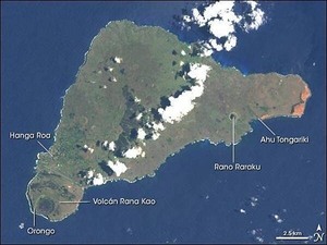
Easter Island, one of the most remote locations on Earth, is more than 3,200 km (2,000 mi) from the closest populations on Tahiti or Chile. Less than 25 km (15 mi) long, the island is dominated by volcanic landforms, including the large crater Rana Kao at the southwest end of the island and a line of cinder cones that stretch north from the central mountain. A final feature (difficult to see) is the very long runway (Chile's longest) near Rana Kao. The airport serves as an emergency space shuttle landing site. Image courtesy of NASA.
Easter Island, one of the most remote locations on Earth, is more than 3,200 km (2,000 mi) from the closest populations on Tahiti or Chile. Less than 25 km (15 mi) long, the island is dominated by volcanic landforms, including the large crater Rana Kao at the southwest end of the island and a line of cinder cones that stretch north from the central mountain. A final feature (difficult to see) is the very long runway (Chile's longest) near Rana Kao. The airport serves as an emergency space shuttle landing site. Image courtesy of NASA. • CIA World Factbook • 2020
Discovered by Dutch sailors on Easter Sunday 1722 and named for the holy day, the isolated Pacific island had already been inhabited for more than one thousand years, most likely settled by Polynesian sailors in canoes between A.D. 400 and 700. The most amazing cultural artifacts on display were giant stone statues, called moai, resting on ahu, raised platforms of expertly fitted stones. Most of the hundreds of moai on the island were carved out of volcanic rock in the crater of Rano Raraku, located in the southeastern part of the island. In addition to the many moai scattered around the coast of the island, Rano Raraku is littered with moai, some only half-carved, others that appear to have broken in the attempt to remove them from the quarry, and still others that seem to simply have been abandoned. East of Rano Raraku is Ahu Tongariki, where in 1960 a tidal wave caused by an earthquake in Chile struck the southern coastline and swept 15 moai inland for several hundred feet. In 1992, the site was restored by a Chilean archeologist. On the western end of the island is the only town, Hanga Roa, where most of Rapa Nui's 2,000 residents live. South of the town is the island's largest volcanic crater, Rana Kao. Along the crater rim looking southward over the coast, lie the ruins of Orongo, a ceremonial site containing elaborate stone carvings and other artwork. Landsat image courtesy of NASA.
Discovered by Dutch sailors on Easter Sunday 1722 and named for the holy day, the isolated Pacific island had already been inhabited for more than one thousand years, most likely settled by Polynesian sailors in canoes between A.D. 400 and 700. The most amazing cultural artifacts on display were giant stone statues, called moai, resting on ahu, raised platforms of expertly fitted stones. Most of the hundreds of moai on the island were carved out of volcanic rock in the crater of Rano Raraku, located in the southeastern part of the island. In addition to the many moai scattered around the coast of the island, Rano Raraku is littered with moai, some only half-carved, others that appear to have broken in the attempt to remove them from the quarry, and still others that seem to simply have been abandoned. East of Rano Raraku is Ahu Tongariki, where in 1960 a tidal wave caused by an earthquake in Chile struck the southern coastline and swept 15 moai inland for several hundred feet. In 1992, the site was restored by a Chilean archeologist. On the western end of the island is the only town, Hanga Roa, where most of Rapa Nui's 2,000 residents live. South of the town is the island's largest volcanic crater, Rana Kao. Along the crater rim looking southward over the coast, lie the ruins of Orongo, a ceremonial site containing elaborate stone carvings and other artwork. Landsat image courtesy of NASA. • CIA World Factbook • 2020
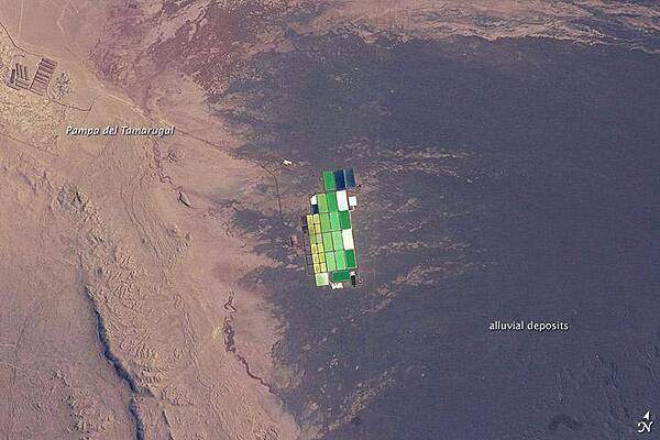
Brightly colored solar evaporation (salt) ponds in a desert landscape give this astronaut photo an unreal quality. The ponds sit near the foot of a long alluvial fan in the Pampa del Tamarugal, the great hyper-arid inner valley of Chile's Atacama Desert. The alluvial fan sediments are dark brown, and they contrast sharply with tan sediments of the Pampa del Tamarugal. Nitrates and many other minerals are mined in this region. A few extraction pits and ore dumps are visible at upper left. Iodine is one of the products from mining; it is first extracted by heap leaching. Waste liquids from the iodine plants are dried in the tan and brightly colored evaporation ponds to crystallize nitrate salts for collection. The recovered nitrates are mainly used for fertilizer for higher-value crops. They are also used in the manufacture of pharmaceuticals, explosives, glass, and ceramics, as well as in water treatment and metallurgical processes. Image courtesy of NASA.
Brightly colored solar evaporation (salt) ponds in a desert landscape give this astronaut photo an unreal quality. The ponds sit near the foot of a long alluvial fan in the Pampa del Tamarugal, the great hyper-arid inner valley of Chile's Atacama Desert. The alluvial fan sediments are dark brown, and they contrast sharply with tan sediments of the Pampa del Tamarugal.
Nitrates and many other minerals are mined in this region. A few extraction pits and ore dumps are visible at upper left. Iodine is one of the products from mining; it is first extracted by heap leaching. Waste liquids from the iodine plants are dried in the tan and brightly colored evaporation ponds to crystallize nitrate salts for collection. The recovered nitrates are mainly used for fertilizer for higher-value crops. They are also used in the manufacture of pharmaceuticals, explosives, glass, and ceramics, as well as in water treatment and metallurgical processes. Image courtesy of NASA. • CIA World Factbook • 2020
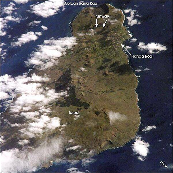
View of Easter Island from space. The island is one of the most remote locations on Earth, being more than 3,200 km (2,000 mi) from the closest populations on Tahiti or Chile. The island is perhaps most famous for the giant stone monoliths, known as moai, that have been placed along the coastline. Archaeologists believe the island was discovered and colonized by Polynesians sometime between A.D. 400 and 700. Subsequently, a unique culture developed. The human population grew to levels that could not be sustained by the island. A civil war resulted, and the island's deforestation and ecosystem collapse was nearly complete. Today, a new forest (primarily eucalyptus) has been established in the center of the island (dark green). Less than 25 km (15 mi) long, the geography of the island is dominated by volcanic landforms, including the large crater Rana Kao at the southwest end of the island and a line of cinder cones that stretch north from the central mountain. A final feature (difficult to see) is the very long runway (Chile's longest) near Rana Kao, which served (but was never used) as an emergency landing site for the Space Shuttle. Image courtesy of NASA.
View of Easter Island from space. The island is one of the most remote locations on Earth, being more than 3,200 km (2,000 mi) from the closest populations on Tahiti or Chile. The island is perhaps most famous for the giant stone monoliths, known as moai, that have been placed along the coastline. Archaeologists believe the island was discovered and colonized by Polynesians sometime between A.D. 400 and 700. Subsequently, a unique culture developed. The human population grew to levels that could not be sustained by the island. A civil war resulted, and the island's deforestation and ecosystem collapse was nearly complete. Today, a new forest (primarily eucalyptus) has been established in the center of the island (dark green). Less than 25 km (15 mi) long, the geography of the island is dominated by volcanic landforms, including the large crater Rana Kao at the southwest end of the island and a line of cinder cones that stretch north from the central mountain. A final feature (difficult to see) is the very long runway (Chile's longest) near Rana Kao, which served (but was never used) as an emergency landing site for the Space Shuttle. Image courtesy of NASA. • CIA World Factbook • 2020
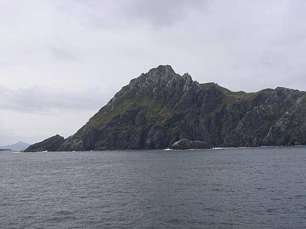
Cape Horn, named after a city in the Netherlands, is the southernmost headland of the Tierra del Fuego archipelago in southern Chile. It is frequently referred to as the "sailors' graveyard" because the waters around the area are particularly hazardous due to strong winds, large waves, strong currents, and icebergs.
Cape Horn, named after a city in the Netherlands, is the southernmost headland of the Tierra del Fuego archipelago in southern Chile. It is frequently referred to as the "sailors' graveyard" because the waters around the area are particularly hazardous due to strong winds, large waves, strong currents, and icebergs. • CIA World Factbook • 2020
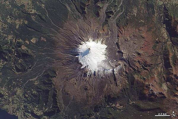
Near the southern tip of South America, a trio of volcanoes lines up perpendicular to the Andes Mountains. The most active is the westernmost, Volcan Villarrica, pictured in this photo-like satellite image. The 2,582-m (9,357-ft) stratovolcano is mantled by a 30-sq km (10-sq mi) glacier field, most of it amassed south and east of the summit in a basin made by a caldera depression. To the east and northeast, the glacier is covered by ash and other volcanic debris, giving it a rumpled, brown look. The western slopes are streaked with innumerable gray-brown gullies, the paths of lava and mudflows (lahars). Beyond the reach of ash and debris deposits, the volcano is surrounded by forests; the area is a national park. The largest recent eruption occurred in the early 1970s; lava flows melted glaciers and generated lahars that spread at speeds of 30-40 km per hour (20-30 mph). Image courtesy of NASA.
Near the southern tip of South America, a trio of volcanoes lines up perpendicular to the Andes Mountains. The most active is the westernmost, Volcan Villarrica, pictured in this photo-like satellite image. The 2,582-m (9,357-ft) stratovolcano is mantled by a 30-sq km (10-sq mi) glacier field, most of it amassed south and east of the summit in a basin made by a caldera depression. To the east and northeast, the glacier is covered by ash and other volcanic debris, giving it a rumpled, brown look. The western slopes are streaked with innumerable gray-brown gullies, the paths of lava and mudflows (lahars). Beyond the reach of ash and debris deposits, the volcano is surrounded by forests; the area is a national park. The largest recent eruption occurred in the early 1970s; lava flows melted glaciers and generated lahars that spread at speeds of 30-40 km per hour (20-30 mph). Image courtesy of NASA. • CIA World Factbook • 2020
CIA World Factbook • 2020
CIA World Factbook • 2020
CIA World Factbook • 2020
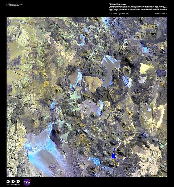
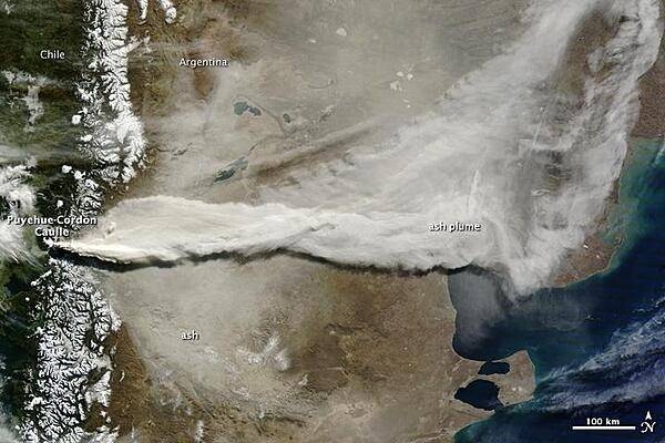
On the border between Chile and the Catamarca province of Argentina lies a vast field of currently dormant volcanoes. Over time, these volcanoes have laid down a crust of magma roughly 3.2 km (2 mi) thick. This enhanced satellite image is tinged with a patina of various colors that can indicate both the age and mineral content of the original lava flows. Some arroyos and alluvial fans may be seen in the upper left portion of the photo. For active volcanoes in Chile and Argentina, see the Natural hazards-volcanism field in the Geography section. Image courtesy of USGS.
On the border between Chile and the Catamarca province of Argentina lies a vast field of currently dormant volcanoes. Over time, these volcanoes have laid down a crust of magma roughly 3.2 km (2 mi) thick. This enhanced satellite image is tinged with a patina of various colors that can indicate both the age and mineral content of the original lava flows. Some arroyos and alluvial fans may be seen in the upper left portion of the photo. For active volcanoes in Chile and Argentina, see the Natural hazards-volcanism field in the Geography section. Image courtesy of USGS. • CIA World Factbook • 2020
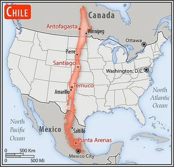
Area comparison map
Area comparison map • CIA World Factbook • 2020
Media source: CIA World Factbook (2020) — Public Domain