›››
China — Media Gallery
102 items available (flags, maps, photos)
Photos
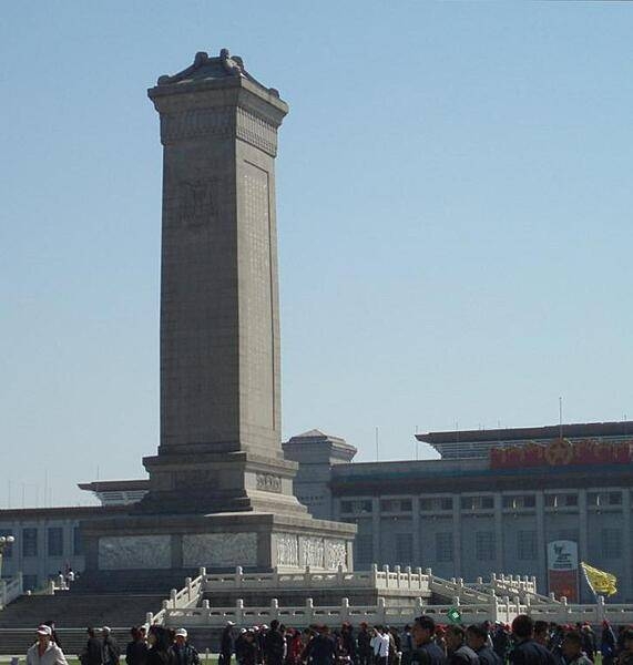
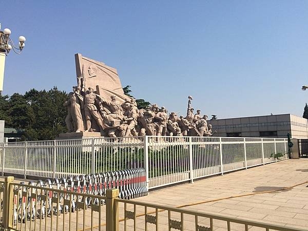
The Monument to the People's Heroes in Tiananmen Square in Beijing. Constructed in 1958, it commemorates those who fought in revolutions from 1840 to 1949.
The Monument to the People's Heroes in Tiananmen Square in Beijing. Constructed in 1958, it commemorates those who fought in revolutions from 1840 to 1949. • CIA World Factbook • 2020
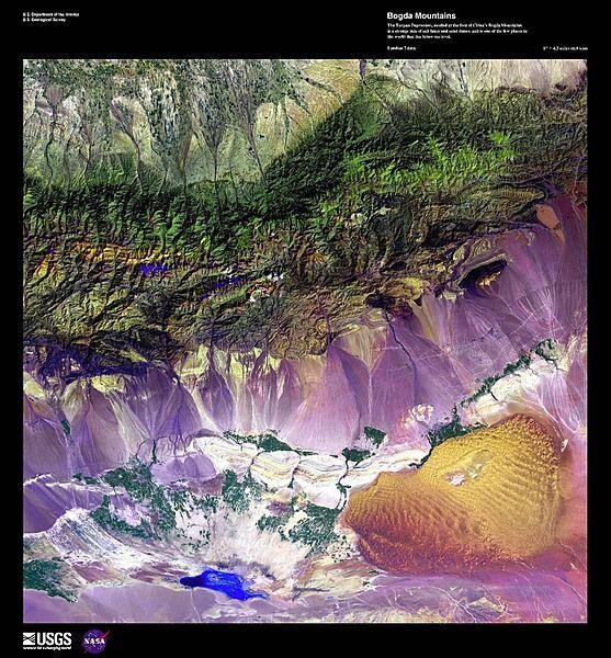
This false-color, high-resolution satellite photo shows the Turpan Depression, nestled at the foot of China's Bogda Mountains, south of the oasis city of Turpan. A strange mix of salt lakes and sand dunes, this fault-bounded trough is the lowest exposed surface in China. At the center of the basin lies Ayding Lake (bottom left), which is the third lowest exposed point on the earth's surface at -154 m (-505 ft). Image courtesy of USGS.
This false-color, high-resolution satellite photo shows the Turpan Depression, nestled at the foot of China's Bogda Mountains, south of the oasis city of Turpan. A strange mix of salt lakes and sand dunes, this fault-bounded trough is the lowest exposed surface in China. At the center of the basin lies Ayding Lake (bottom left), which is the third lowest exposed point on the earth's surface at -154 m (-505 ft). Image courtesy of USGS. • CIA World Factbook • 2020
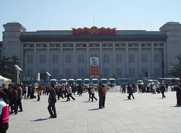
The National Museum of China on Tiananmen Square in Beijing. Completed in 1959, the museum's mission is to educate about the arts and history of China.
The National Museum of China on Tiananmen Square in Beijing. Completed in 1959, the museum's mission is to educate about the arts and history of China. • CIA World Factbook • 2020
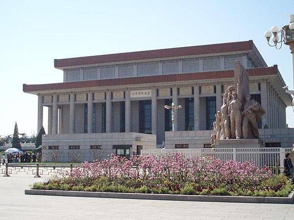
The Mao Zedong Mausoleum (or Chairman Mao Memorial Hall) was constructed in 1977 on Tiananmen Square in Beijing. Mao's body lies in a crystal casket for public viewing.
The Mao Zedong Mausoleum (or Chairman Mao Memorial Hall) was constructed in 1977 on Tiananmen Square in Beijing. Mao's body lies in a crystal casket for public viewing. • CIA World Factbook • 2020
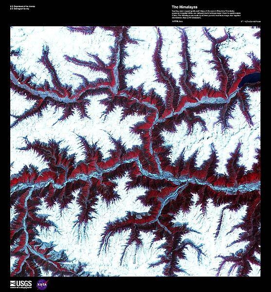
Soaring, snow-capped peaks and ridges of the eastern Himalaya Mountains create an irregular white-on-red patchwork between major rivers in southwestern China in this enhanced satellite image. The Himalayas are made up of three parallel mountain ranges that together extend more than 2,900 km (1,800 mi) and are the youngest mountain range on the planet. Some of the world's major rivers rise in these mountains and their combined drainage basin is home to almost half of the world's entire population. Image courtesy of USGS.
Soaring, snow-capped peaks and ridges of the eastern Himalaya Mountains create an irregular white-on-red patchwork between major rivers in southwestern China in this enhanced satellite image. The Himalayas are made up of three parallel mountain ranges that together extend more than 2,900 km (1,800 mi) and are the youngest mountain range on the planet. Some of the world's major rivers rise in these mountains and their combined drainage basin is home to almost half of the world's entire population. Image courtesy of USGS. • CIA World Factbook • 2020
Snow-covered deserts are rare, but that is exactly what NASA's Aqua satellite observed as it passed over the Takla Makan Desert in the Xinjian Uygyr autonomous region of western China on 2 January 2013. The Takla Makan is one of the world's largest and hottest sandy deserts. Water flowing into the Tarim Basin has no outlet so, over the years, sediments have steadily accumulated. In parts of the desert, sand can pile up to 300 m (roughly 1,000 ft) high. The mountains that enclose the sea of sand - the Tien Shan in the north and the Kunlun Shan in the south - are also covered with what appears to be a significantly thicker layer of snow. Image courtesy of NASA.
Snow-covered deserts are rare, but that is exactly what NASA's Aqua satellite observed as it passed over the Takla Makan Desert in the Xinjian Uygyr autonomous region of western China on 2 January 2013. The Takla Makan is one of the world's largest and hottest sandy deserts. Water flowing into the Tarim Basin has no outlet so, over the years, sediments have steadily accumulated. In parts of the desert, sand can pile up to 300 m (roughly 1,000 ft) high. The mountains that enclose the sea of sand - the Tien Shan in the north and the Kunlun Shan in the south - are also covered with what appears to be a significantly thicker layer of snow. Image courtesy of NASA. • CIA World Factbook • 2020
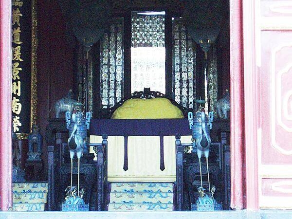
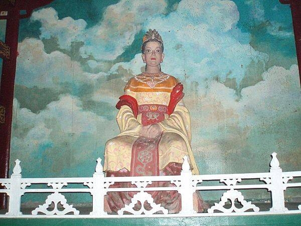
Throne hall in the emperor's administrative area close to the East Gate of the Summer Palace in Beijing.
Throne hall in the emperor's administrative area close to the East Gate of the Summer Palace in Beijing. • CIA World Factbook • 2020
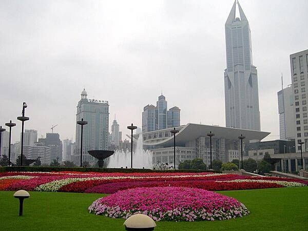
The Grand Theater in Shanghai, the largest city in China with over 20 million citizens. Shanghai was a multinational hub of finance and business in the 1930's before its development and prosperity were set back by half a century of Communism. Economic reforms of the 1990s revitalized the city. Today it is the largest center of commerce and investment in China, as well as a popular tourist destination. The distinctive tall building in the background, Tomorrow Square, houses a hotel and apartment units.
The Grand Theater in Shanghai, the largest city in China with over 20 million citizens. Shanghai was a multinational hub of finance and business in the 1930's before its development and prosperity were set back by half a century of Communism. Economic reforms of the 1990s revitalized the city. Today it is the largest center of commerce and investment in China, as well as a popular tourist destination. The distinctive tall building in the background, Tomorrow Square, houses a hotel and apartment units. • CIA World Factbook • 2020
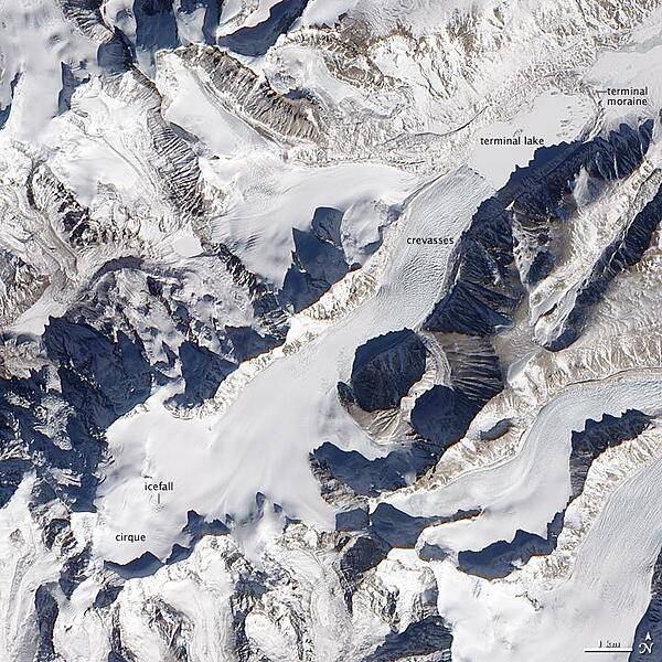
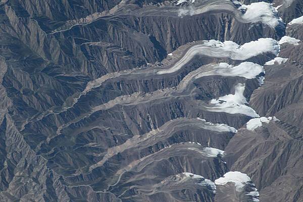
Besides the world's tallest peaks, the Himalayan Mountain Range holds thousands of glaciers. In southern China, just north of the border with Nepal, one unnamed Himalayan glacier flows from southwest to northeast, creeping down a valley terminating in a glacial lake. Shown in this natural-color satellite image, mountains on either side of the glacier cast long shadows to the northwest. From a bowl-shaped cirque, the glacier flows downhill. Where the ice passes over especially steep terrain, ripple marks on the glacier surface indicate the icefall. Northeast of the icefall, the glacier's surface is mostly smooth for several kilometers until a network of crevasses mark the surface. At the end of the glacier's deeply crevassed snout sits a glacial lake, coated with ice in this wintertime picture. Just as nearby mountains cast shadows, the crevassed glacier casts small shadows onto the lake's icy surface. This glacial lake is bound by the glacier snout on one end, and a moraine - a mound formed by the accumulation of sediments and rocks moved by the glacier - on the other. Image courtesy of NASA.
Besides the world's tallest peaks, the Himalayan Mountain Range holds thousands of glaciers. In southern China, just north of the border with Nepal, one unnamed Himalayan glacier flows from southwest to northeast, creeping down a valley terminating in a glacial lake. Shown in this natural-color satellite image, mountains on either side of the glacier cast long shadows to the northwest. From a bowl-shaped cirque, the glacier flows downhill. Where the ice passes over especially steep terrain, ripple marks on the glacier surface indicate the icefall. Northeast of the icefall, the glacier's surface is mostly smooth for several kilometers until a network of crevasses mark the surface. At the end of the glacier's deeply crevassed snout sits a glacial lake, coated with ice in this wintertime picture. Just as nearby mountains cast shadows, the crevassed glacier casts small shadows onto the lake's icy surface. This glacial lake is bound by the glacier snout on one end, and a moraine - a mound formed by the accumulation of sediments and rocks moved by the glacier - on the other. Image courtesy of NASA. • CIA World Factbook • 2020
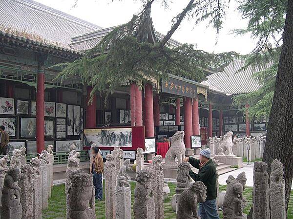
The Forest of Stone Stelae museum in Xi'an is located in what was formerly a Confucian temple. Some 3,000 inscribed stelae and stone carvings are housed at this site that has been called the "Cradle of Calligraphy."
The Forest of Stone Stelae museum in Xi'an is located in what was formerly a Confucian temple. Some 3,000 inscribed stelae and stone carvings are housed at this site that has been called the "Cradle of Calligraphy." • CIA World Factbook • 2020
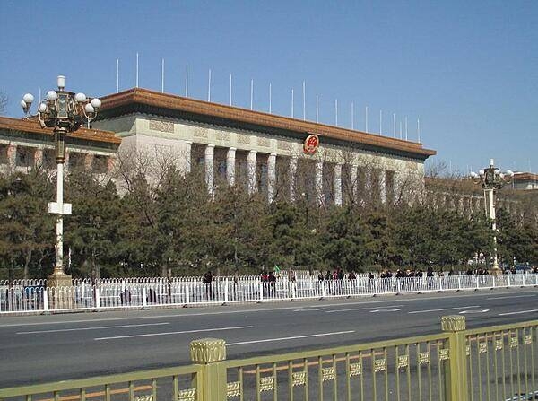
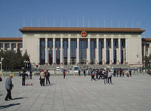
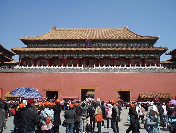
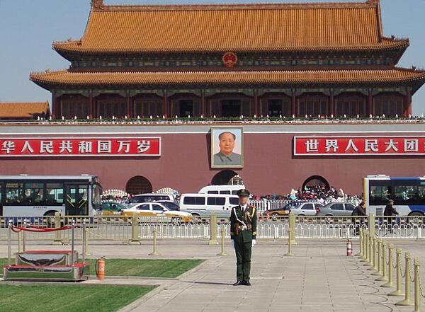
Approaching the Great Hall of the People in Tiananmen Square in Beijing. The building was constructed in 1959; it is the home of the National People's Congress.
Approaching the Great Hall of the People in Tiananmen Square in Beijing. The building was constructed in 1959; it is the home of the National People's Congress. • CIA World Factbook • 2020
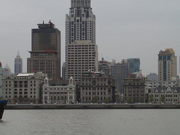
View of The Bund area in Shanghai from across the Huongpu River. "Bund" is an Anglo-Indian word for an embankment of a muddy waterfront.
View of The Bund area in Shanghai from across the Huongpu River. "Bund" is an Anglo-Indian word for an embankment of a muddy waterfront. • CIA World Factbook • 2020
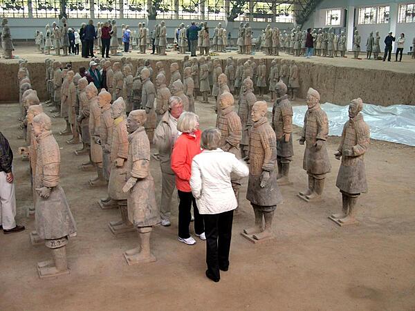
Some of the terra cotta warriors found in the mausoleum of the first Chinese Emperor Qin Shi Huang (221-210 B.C.) in Xi'an. The tomb, under an earthen pyramid, was discovered in 1974 and excavations are ongoing. The ceramic army that accompanied the ruler into the afterlife is estimated to consist of over 8,000 soldiers (each with a unique face), 100 chariots with 400 horses, and 300 cavalry horses.
Some of the terra cotta warriors found in the mausoleum of the first Chinese Emperor Qin Shi Huang (221-210 B.C.) in Xi'an. The tomb, under an earthen pyramid, was discovered in 1974 and excavations are ongoing. The ceramic army that accompanied the ruler into the afterlife is estimated to consist of over 8,000 soldiers (each with a unique face), 100 chariots with 400 horses, and 300 cavalry horses. • CIA World Factbook • 2020
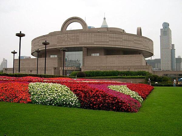
The Shanghai Museum of Ancient Art was founded in 1952 in the club house of the former Shanghai Racecourse. A new building - constructed in the form of an ancient bronze cooking vessel called a ding - was opened in 1996 on People's Square. It houses some 120,000 items including bronzes, ceramics, paintings, calligraphy, furniture, jades, ancient coins, seals, and sculptures.
The Shanghai Museum of Ancient Art was founded in 1952 in the club house of the former Shanghai Racecourse. A new building - constructed in the form of an ancient bronze cooking vessel called a ding - was opened in 1996 on People's Square. It houses some 120,000 items including bronzes, ceramics, paintings, calligraphy, furniture, jades, ancient coins, seals, and sculptures. • CIA World Factbook • 2020
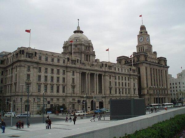
View of The Bund area in Shanghai. Most of the buildings were built in the early 20th century in a Neoclassical style by European and American businesses.
View of The Bund area in Shanghai. Most of the buildings were built in the early 20th century in a Neoclassical style by European and American businesses. • CIA World Factbook • 2020
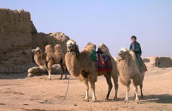
Camels outside of Gaochang, the ruins of an ancient city 30 km (18 mi) southeast of Turpan. Built in the first century B.C., it was an important hub along the Silk Road. The city was burnt and destroyed in wars of the 14th century, but many impressive temple and palace ruins remain.
Camels outside of Gaochang, the ruins of an ancient city 30 km (18 mi) southeast of Turpan. Built in the first century B.C., it was an important hub along the Silk Road. The city was burnt and destroyed in wars of the 14th century, but many impressive temple and palace ruins remain. • CIA World Factbook • 2020
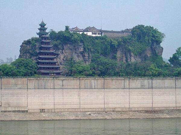
Shibaozhai is a steep, rocky, and craggy hill on the bank of the Yangtze River, in Zhong county, Chongqing. A temple at the crest of the 220 m (722 ft) hill was built in the 18th century. A nine-story wooden pagoda was constructed in the 1819 to aid pilgrims in getting to the top of the hill. In 1956, three more stories were added. A coffer dam protects the site from higher river waters - the result of the Three Gorges Dam.
Shibaozhai is a steep, rocky, and craggy hill on the bank of the Yangtze River, in Zhong county, Chongqing. A temple at the crest of the 220 m (722 ft) hill was built in the 18th century. A nine-story wooden pagoda was constructed in the 1819 to aid pilgrims in getting to the top of the hill. In 1956, three more stories were added. A coffer dam protects the site from higher river waters - the result of the Three Gorges Dam. • CIA World Factbook • 2020
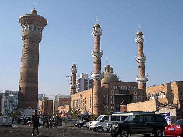
The mosque in downtown Urumqi, Xinjiang Province was built in 1919. One of the most beautiful parts of the structure is its prayer hall, decorated with glazed tiles in colorful patterns of flowers and plants.
The mosque in downtown Urumqi, Xinjiang Province was built in 1919. One of the most beautiful parts of the structure is its prayer hall, decorated with glazed tiles in colorful patterns of flowers and plants. • CIA World Factbook • 2020
CIA World Factbook • 2020
The Huangling Temple in Sandouping - site of the Three Gorges Dam - dates back to 1618.
The Huangling Temple in Sandouping - site of the Three Gorges Dam - dates back to 1618. • CIA World Factbook • 2020
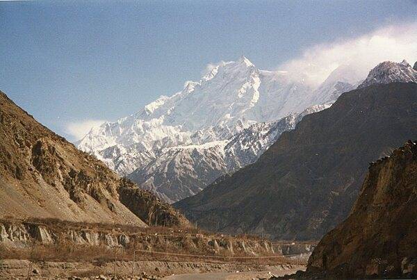
The Karakoram Highway between Gilgit and Khunjerab Pass. A joint Chinese-Pakistan venture, the 1,300 km highway connects Gilgit-Baltistan in Pakistan with the Xinjiang Uygur Autonomous Region in China. It is one of the highest all-weather roads in the world crossing the Khunjerab Pass over the Karakoram Mountains at an elevation of 4,714 m. The highway follows one of the branches of the ancient Silk Road.
The Karakoram Highway between Gilgit and Khunjerab Pass. A joint Chinese-Pakistan venture, the 1,300 km highway connects Gilgit-Baltistan in Pakistan with the Xinjiang Uygur Autonomous Region in China. It is one of the highest all-weather roads in the world crossing the Khunjerab Pass over the Karakoram Mountains at an elevation of 4,714 m. The highway follows one of the branches of the ancient Silk Road. • CIA World Factbook • 2020
In southeastern Mongolia, roughly halfway between Ulaanbaatar and Beijing, lies an ancient crater. Tabun Khara Obo was first identified as a probable impact crater in 1976, but confirmation did not occurr until decades later. Drilling at the site in 2008 revealed rock features consistent with high-speed impacts such as those caused by meteorites. The dark, irregularly shaped area in the lower right corner of the image is vegetation along a river channel. Photo courtesy of NASA.
In southeastern Mongolia, roughly halfway between Ulaanbaatar and Beijing, lies an ancient crater. Tabun Khara Obo was first identified as a probable impact crater in 1976, but confirmation did not occurr until decades later. Drilling at the site in 2008 revealed rock features consistent with high-speed impacts such as those caused by meteorites. The dark, irregularly shaped area in the lower right corner of the image is vegetation along a river channel. Photo courtesy of NASA. • CIA World Factbook • 2020
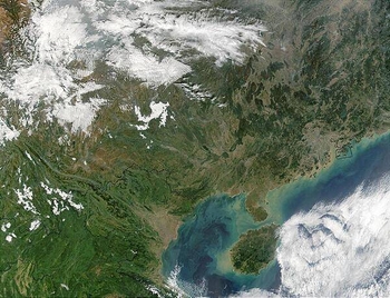
A view of Southern China and the Gulf of Tonkin. At the center-right of the image, circled in a black outline, is the island of Hong Kong. Hong Kong sits on the South China Sea, which is mostly under cloud cover in this image. West of the South China Sea is the island of Hainan, seen at bottom-center, which separates the sea from the Gulf of Tonkin to the west. In this image, the Gulf of Tonkin is saturated with what seems to be a mixture of sediment and phytoplankton. Photo courtesy of NASA.
A view of Southern China and the Gulf of Tonkin. At the center-right of the image, circled in a black outline, is the island of Hong Kong. Hong Kong sits on the South China Sea, which is mostly under cloud cover in this image. West of the South China Sea is the island of Hainan, seen at bottom-center, which separates the sea from the Gulf of Tonkin to the west. In this image, the Gulf of Tonkin is saturated with what seems to be a mixture of sediment and phytoplankton. Photo courtesy of NASA. • CIA World Factbook • 2020
The decorated and walled entrance at the base of the Shibaozhai Pagoda.
The decorated and walled entrance at the base of the Shibaozhai Pagoda. • CIA World Factbook • 2020
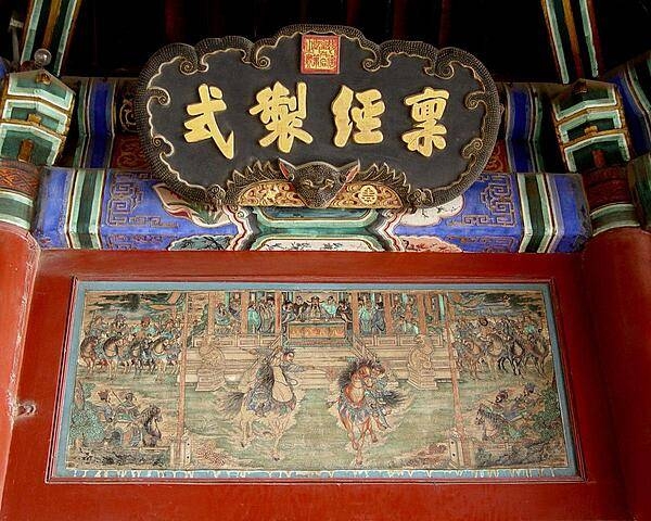
Close up of one of the Long Corridor murals at the Summer Palace in Beijing.
Close up of one of the Long Corridor murals at the Summer Palace in Beijing. • CIA World Factbook • 2020
This detailed photograph taken from the International Space Station highlights the northern approach to Mount Everest from Tibet. Known as the northeast ridge route, climbers travel along the East Rongbuk Glacier (top right) to camp at the base of Changtse Mountain. From this point at approximately 6,100 m (20,000 ft) above sea level, the North Col - a sharp-edged pass carved by glaciers, center - is ascended to reach a series of progressively higher camps along the North Face of Everest, culminating in Camp VI at 8,230 m (27,000 ft) above sea level. Climbers make their final push to the summit (not visible, just off the bottom edge of the image) from this altitude. Image courtesy of NASA.
This detailed photograph taken from the International Space Station highlights the northern approach to Mount Everest from Tibet. Known as the northeast ridge route, climbers travel along the East Rongbuk Glacier (top right) to camp at the base of Changtse Mountain. From this point at approximately 6,100 m (20,000 ft) above sea level, the North Col - a sharp-edged pass carved by glaciers, center - is ascended to reach a series of progressively higher camps along the North Face of Everest, culminating in Camp VI at 8,230 m (27,000 ft) above sea level. Climbers make their final push to the summit (not visible, just off the bottom edge of the image) from this altitude. Image courtesy of NASA. • CIA World Factbook • 2020
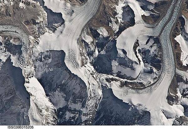
Glaciers in the Qilian Mountain range of central China as viewed from the International Space Station at an altitude of about 400 km (250 mi). The icy tongues extend to the left from the higher elevations at the right. Image courtesy of NASA.
Glaciers in the Qilian Mountain range of central China as viewed from the International Space Station at an altitude of about 400 km (250 mi). The icy tongues extend to the left from the higher elevations at the right. Image courtesy of NASA. • CIA World Factbook • 2020
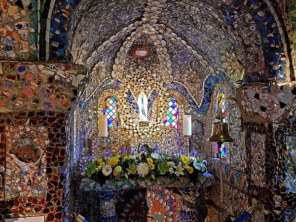
Interior of The Little Chapel in Les Vauxbelets Valley in Guernsey, constructed in 1914 by a Brother Deodat using broken china, seashells, and pebbles. The Chapel is thought to be the smallest consecrated chapel in the world.
Interior of The Little Chapel in Les Vauxbelets Valley in Guernsey, constructed in 1914 by a Brother Deodat using broken china, seashells, and pebbles. The Chapel is thought to be the smallest consecrated chapel in the world. • CIA World Factbook • 2020
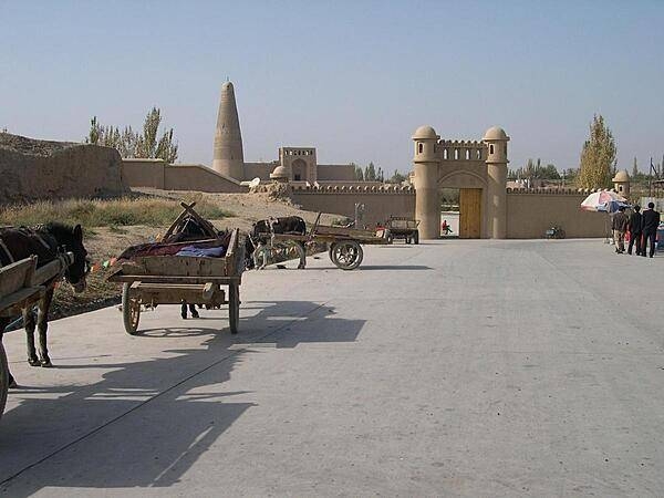
Approaching the Emin Mosque and Minaret in Turpan, an oasis city in Xinjiang Uygur Autonomous Province. The Emin Minaret was begun in 1777 and completed in only one year. It is the tallest minaret in China (44 m, 144 ft) and is named in honor of Emin Khoja, a heroic Turpan general.
Approaching the Emin Mosque and Minaret in Turpan, an oasis city in Xinjiang Uygur Autonomous Province. The Emin Minaret was begun in 1777 and completed in only one year. It is the tallest minaret in China (44 m, 144 ft) and is named in honor of Emin Khoja, a heroic Turpan general. • CIA World Factbook • 2020
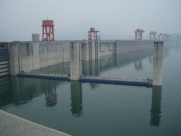
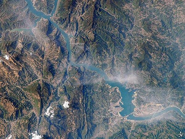
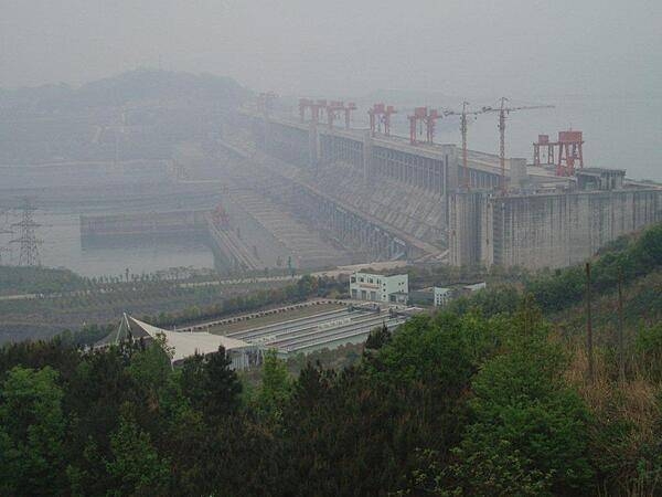
The Three Gorges Dam at Sandouping is the largest hydroelectric power station in the world. It provides power and controls water flow to prevent floods and to supply water downstream during times of drought. Its construction forced the relocation of 1.3 million people and the flooding of thousands of cities, towns, and historical sites. This is a view of the reservoir behind the dam.
The Three Gorges Dam at Sandouping is the largest hydroelectric power station in the world. It provides power and controls water flow to prevent floods and to supply water downstream during times of drought. Its construction forced the relocation of 1.3 million people and the flooding of thousands of cities, towns, and historical sites. This is a view of the reservoir behind the dam. • CIA World Factbook • 2020
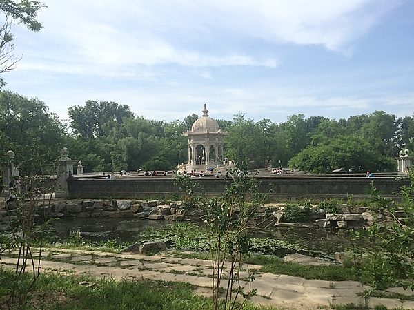
The Summer Palace is a vast ensemble of lakes, gardens, and palaces in Beijing. It was an imperial garden in the Qing dynasty (1644 to 1912). UNESCO added the Summer Palace to its World Heritage List in 1998. This view shows a folly on the grounds of the Summer Palace in Beijing.
The Summer Palace is a vast ensemble of lakes, gardens, and palaces in Beijing. It was an imperial garden in the Qing dynasty (1644 to 1912). UNESCO added the Summer Palace to its World Heritage List in 1998. This view shows a folly on the grounds of the Summer Palace in Beijing. • CIA World Factbook • 2020
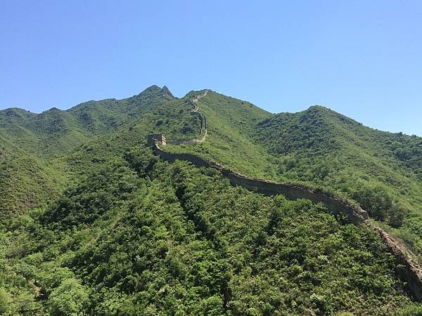
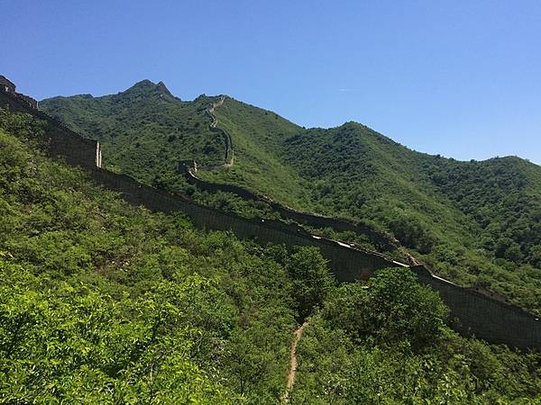
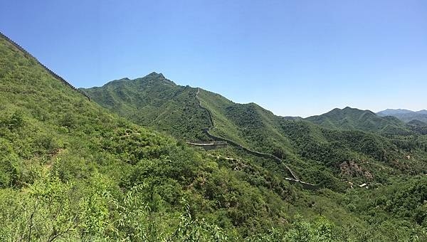
The Huanghuacheng (Lakeside) section of the Great Wall derives its name from the nearby man-made reservoir lakes. Unlike the main tourist sections of the Great Wall at Mutianyu and Badaling, the Lakeside Great Wall draws a far smaller number of tourists. The section features appealing sights including submerged parts of the Great Wall under the lake water and a sweeping view after a steep hike to a high guard tower.
The Huanghuacheng (Lakeside) section of the Great Wall derives its name from the nearby man-made reservoir lakes. Unlike the main tourist sections of the Great Wall at Mutianyu and Badaling, the Lakeside Great Wall draws a far smaller number of tourists. The section features appealing sights including submerged parts of the Great Wall under the lake water and a sweeping view after a steep hike to a high guard tower. • CIA World Factbook • 2020
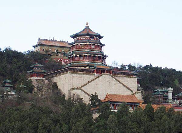
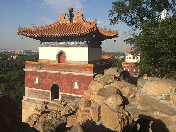
The Tower of Buddhist Incense rises over the Temple of Buddhist Virtue at the Summer Palace in Beijing. The Palace - termed the Gardens of Nurtured Harmony in Chinese - was a summer resort for the imperial family. It consists of palaces, gardens, a lake, and a hill. Gardens have been at the site since the 12th century; construction of the Summer Palace began in 1750.
The Tower of Buddhist Incense rises over the Temple of Buddhist Virtue at the Summer Palace in Beijing. The Palace - termed the Gardens of Nurtured Harmony in Chinese - was a summer resort for the imperial family. It consists of palaces, gardens, a lake, and a hill. Gardens have been at the site since the 12th century; construction of the Summer Palace began in 1750. • CIA World Factbook • 2020
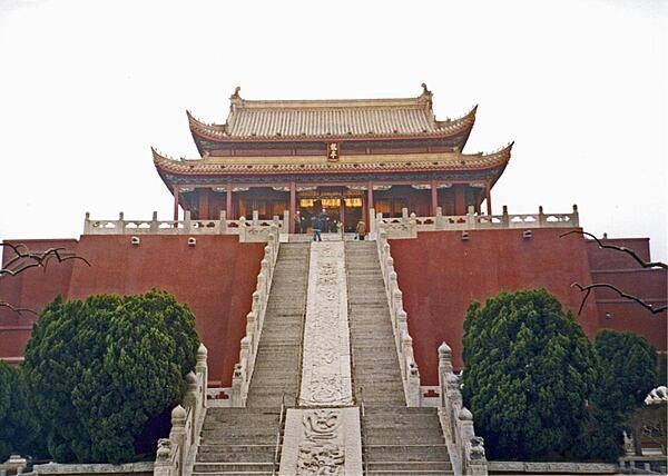
The Main Hall of the Longting (Dragon) Pavilion in Kaifeng, Henan province, dates to 1734.
The Main Hall of the Longting (Dragon) Pavilion in Kaifeng, Henan province, dates to 1734. • CIA World Factbook • 2020
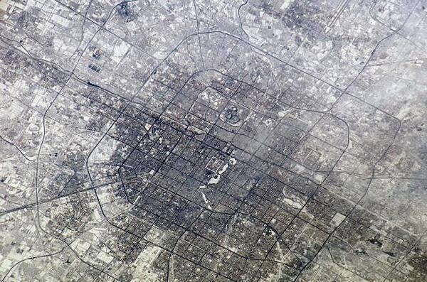
The concentric street patterns of Beijing are clearly visible in this photo taken from the International Space Station. The rectangular area in the center is the Palace Museum also known as the Forbidden City. The area of buildings north of the Forbidden City contains a number of universities. Beijing is surrounded by six ring roads or beltways, four of which may be seen in this photo. The 1st Ring Road no longer functions as an expressway. Image courtesy of NASA.
The concentric street patterns of Beijing are clearly visible in this photo taken from the International Space Station. The rectangular area in the center is the Palace Museum also known as the Forbidden City. The area of buildings north of the Forbidden City contains a number of universities. Beijing is surrounded by six ring roads or beltways, four of which may be seen in this photo. The 1st Ring Road no longer functions as an expressway. Image courtesy of NASA. • CIA World Factbook • 2020
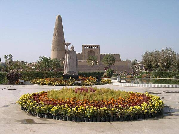
Gardens surround the Emin Mosque and Minaret in Turpan. A statue of Emin Khoja stands before the minaret.
Gardens surround the Emin Mosque and Minaret in Turpan. A statue of Emin Khoja stands before the minaret. • CIA World Factbook • 2020
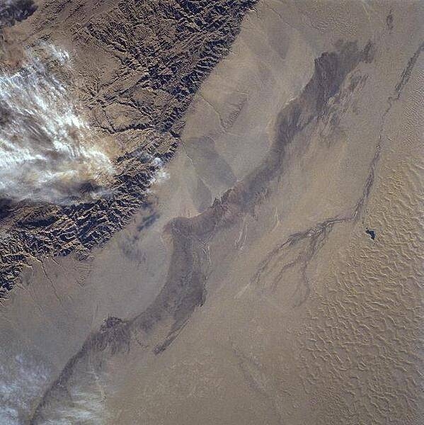
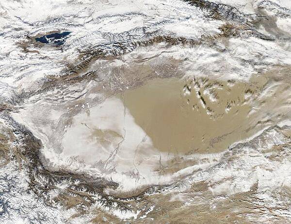
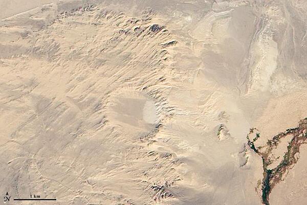
The rugged texture of the Altun Mountains (upper left) that forms part of the northern boundary of the Tibetan Plateau contrasts dramatically with the Takla Makan Desert of western China. Immediately north (to the right) of the mountains are large alluvial fans, gradually sloping downward in elevation. Sand dunes and sand ridges are visible along the northern (lower right) margin of the image. Click on photo for higher resolution. Image courtesy of NASA.
The rugged texture of the Altun Mountains (upper left) that forms part of the northern boundary of the Tibetan Plateau contrasts dramatically with the Takla Makan Desert of western China. Immediately north (to the right) of the mountains are large alluvial fans, gradually sloping downward in elevation. Sand dunes and sand ridges are visible along the northern (lower right) margin of the image. Click on photo for higher resolution. Image courtesy of NASA. • CIA World Factbook • 2020
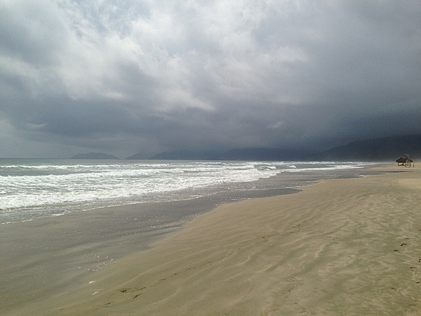
Low-hanging clouds threaten a deserted My Khe Beach (China Beach) near Da Nang.
Low-hanging clouds threaten a deserted My Khe Beach (China Beach) near Da Nang. • CIA World Factbook • 2020
In front of the Great Hall of the People in Tiananmen Square in Beijing.
In front of the Great Hall of the People in Tiananmen Square in Beijing. • CIA World Factbook • 2020
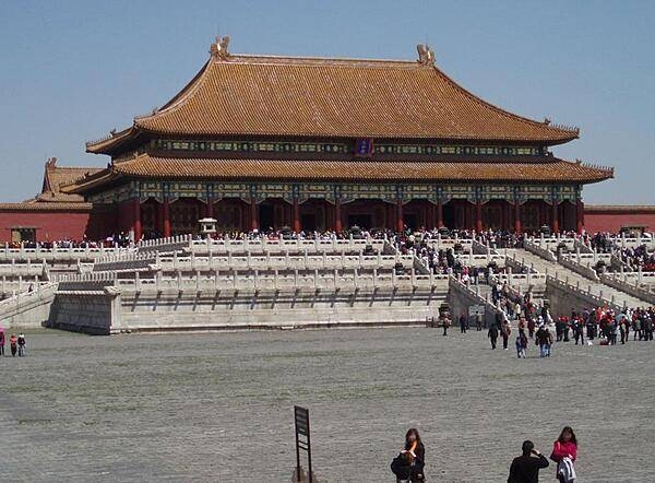
The Hall of Supreme Harmony as seen from the Inner Courtyard of the Forbidden City in Beijing. The Hall was destroyed by fire seven times and was last rebuilt in 1695-97. Many of the buildings of the Forbidden City were built from precious woods and marble; golden bricks were used for floors.
The Hall of Supreme Harmony as seen from the Inner Courtyard of the Forbidden City in Beijing. The Hall was destroyed by fire seven times and was last rebuilt in 1695-97. Many of the buildings of the Forbidden City were built from precious woods and marble; golden bricks were used for floors. • CIA World Factbook • 2020
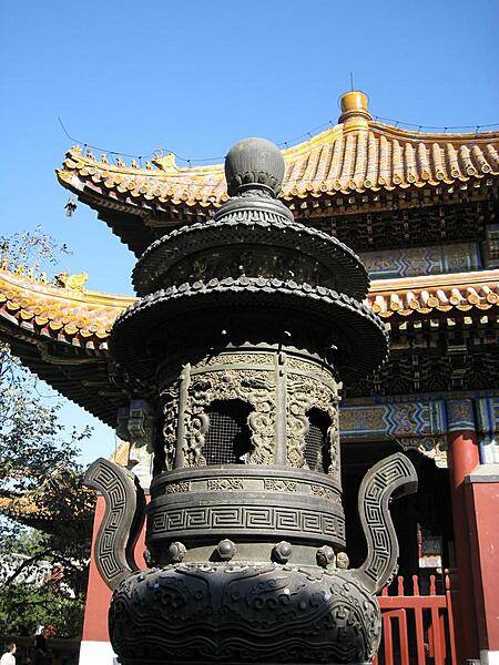
The Lama Temple in Beijing was originally built in 1694 to house court eunuchs. Sometimes called the Palace of Peace and Harmony, it now serves as a Buddhist monastery. This pavilion and the incense burner in the foreground are part of the Temple complex.
The Lama Temple in Beijing was originally built in 1694 to house court eunuchs. Sometimes called the Palace of Peace and Harmony, it now serves as a Buddhist monastery. This pavilion and the incense burner in the foreground are part of the Temple complex. • CIA World Factbook • 2020
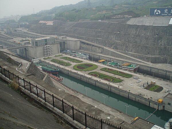
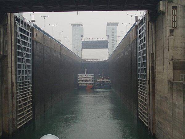
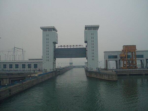
The five-stage locks at the Three Gorges Dam at Sandouping. The locks were constructed to increase river shipping by up to 10 times and to cut transportation costs by one third.
The five-stage locks at the Three Gorges Dam at Sandouping. The locks were constructed to increase river shipping by up to 10 times and to cut transportation costs by one third. • CIA World Factbook • 2020
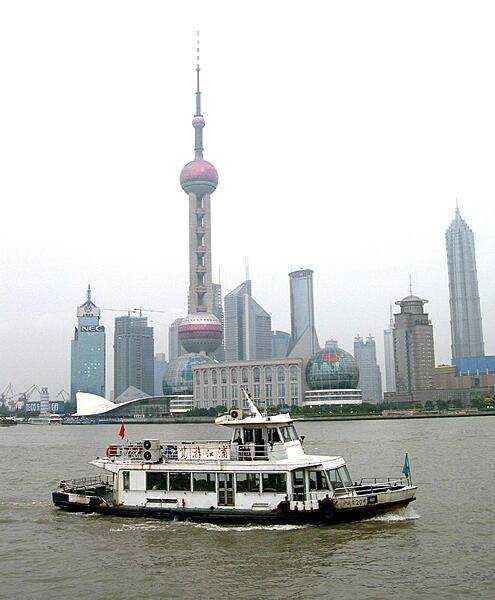
The Oriental Pearl Tower in Shanghai overlooks the Huangpu River. Designed by a local architectural company and completed in 1995, it is 468 m (1,535 ft) tall and has a revolving restaurant, exhibition facilities, restaurants, a shopping mall, and the Space Hotel. The antenna for TV and radio broadcasting adds 118 m (387 ft) to the total height.
The Oriental Pearl Tower in Shanghai overlooks the Huangpu River. Designed by a local architectural company and completed in 1995, it is 468 m (1,535 ft) tall and has a revolving restaurant, exhibition facilities, restaurants, a shopping mall, and the Space Hotel. The antenna for TV and radio broadcasting adds 118 m (387 ft) to the total height. • CIA World Factbook • 2020
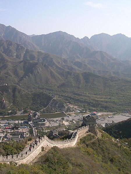
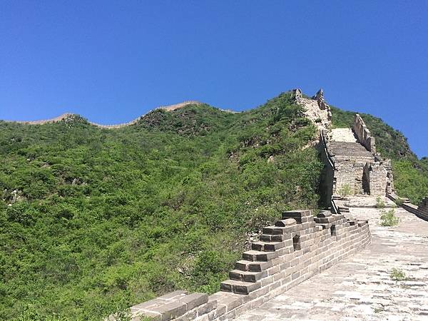
The Juyongguan section of the Great Wall is closest to Beijing and is therefore its most visited portion. Most of the existing Great Wall was built during the Ming Dynasty (14th to 17th centuries) to protect the northern borders of the Chinese Empire. The Manchus conquered the Empire in the mid-17th century and established the Qing Dynasty; they added so much more territory to the Empire beyond the Great Wall that the structure was no longer needed to protect the Empire from outside invaders.
The Juyongguan section of the Great Wall is closest to Beijing and is therefore its most visited portion. Most of the existing Great Wall was built during the Ming Dynasty (14th to 17th centuries) to protect the northern borders of the Chinese Empire. The Manchus conquered the Empire in the mid-17th century and established the Qing Dynasty; they added so much more territory to the Empire beyond the Great Wall that the structure was no longer needed to protect the Empire from outside invaders. • CIA World Factbook • 2020
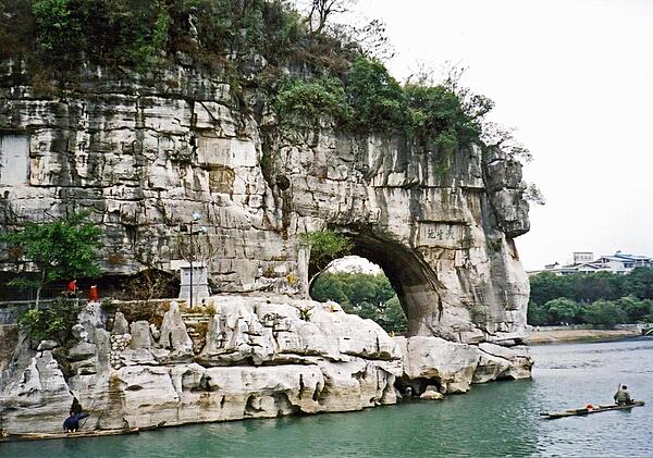
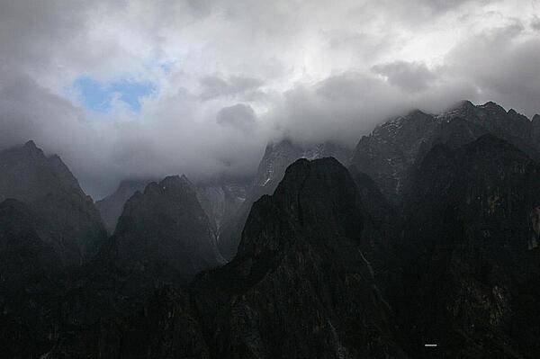
Elephant Trunk Hill, located on the western bank of the Li River, is the symbol of Guilin city.
Elephant Trunk Hill, located on the western bank of the Li River, is the symbol of Guilin city. • CIA World Factbook • 2020
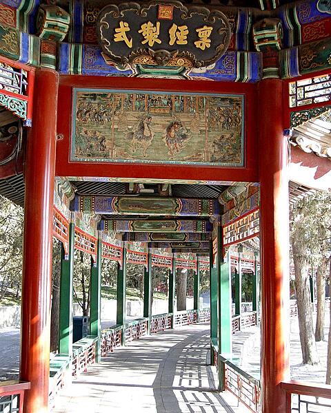
Section of the Long Corridor, a covered walkway of the Summer Palace in Beijing. Erected in the middle of the 18th century, the corridor is famous for its great length (728 m) as well as its elaborate decoration (more than 14,000 paintings).
Section of the Long Corridor, a covered walkway of the Summer Palace in Beijing. Erected in the middle of the 18th century, the corridor is famous for its great length (728 m) as well as its elaborate decoration (more than 14,000 paintings). • CIA World Factbook • 2020
The Palace of Heavenly Purity is the largest of three halls in the Inner Court of the Forbidden City in Beijing. It served as the audience hall during the Qing Dynasty (1644 to 1912).
The Palace of Heavenly Purity is the largest of three halls in the Inner Court of the Forbidden City in Beijing. It served as the audience hall during the Qing Dynasty (1644 to 1912). • CIA World Factbook • 2020
A close-up of the colorful architecture at the Temple of Confucius in Beijing. Initially built in 1302, the temple was used by imperial officials to pay homage to the ancient philosopher and educator.
A close-up of the colorful architecture at the Temple of Confucius in Beijing. Initially built in 1302, the temple was used by imperial officials to pay homage to the ancient philosopher and educator. • CIA World Factbook • 2020
The Gezhouba Dam locks on the Yangtze River. The dam - completed in 1988 - is 38 km downstream (east) of the Three Gorges Dam. Here the water level in the locks has been lowered to receive vessels.
The Gezhouba Dam locks on the Yangtze River. The dam - completed in 1988 - is 38 km downstream (east) of the Three Gorges Dam. Here the water level in the locks has been lowered to receive vessels. • CIA World Factbook • 2020
The north facade of the Meridian Gate in Beijing's Forbidden City.
The north facade of the Meridian Gate in Beijing's Forbidden City. • CIA World Factbook • 2020
Gate towers at the Summer Palace in Beijing.
Gate towers at the Summer Palace in Beijing. • CIA World Factbook • 2020
The Huanghuacheng (Lakeside) section of the Great Wall derives its name from the nearby man-made reservoir lakes. Unlike the main tourist sections of the Great Wall at Mutianyu and Badaling, the Lakeside Great Wall draws a far smaller number of tourists. The section features appealing sights including submerged parts of the Great Wall under the lake water and a sweeping view after a steep hike to a high guard tower.
The Huanghuacheng (Lakeside) section of the Great Wall derives its name from the nearby man-made reservoir lakes. Unlike the main tourist sections of the Great Wall at Mutianyu and Badaling, the Lakeside Great Wall draws a far smaller number of tourists. The section features appealing sights including submerged parts of the Great Wall under the lake water and a sweeping view after a steep hike to a high guard tower. • CIA World Factbook • 2020
An image from 15 April 2009 showing the Three Gorges Dam on the Yangtze River and the flooding upriver from the dam. The main purposes for the dam are twofold: to supply water for the largest hydroelectric plant in the world and to help control the devastating floods that plague the lowlands downstream from the dam. The epic scale of the dam project is matched by the level of controversy it continues to generate. Concerns about major environmental impacts, the relocation of 1.3 million people, and the flooding of 13 cities, more than 1,300 villages, archeological locations, and hazardous waste dumps were raised throughout the planning and implementation. Environmental concerns include increased seismicity from the loading of the water, landslides, changed ecosystems, accumulated pollution, increased chances for waterborne diseases, and salinity changes in the Yangtze estuary. Photo courtesy of NASA.
An image from 15 April 2009 showing the Three Gorges Dam on the Yangtze River and the flooding upriver from the dam. The main purposes for the dam are twofold: to supply water for the largest hydroelectric plant in the world and to help control the devastating floods that plague the lowlands downstream from the dam. The epic scale of the dam project is matched by the level of controversy it continues to generate. Concerns about major environmental impacts, the relocation of 1.3 million people, and the flooding of 13 cities, more than 1,300 villages, archeological locations, and hazardous waste dumps were raised throughout the planning and implementation. Environmental concerns include increased seismicity from the loading of the water, landslides, changed ecosystems, accumulated pollution, increased chances for waterborne diseases, and salinity changes in the Yangtze estuary. Photo courtesy of NASA. • CIA World Factbook • 2020
The entrance to the Shibaozhai Temple.
The entrance to the Shibaozhai Temple. • CIA World Factbook • 2020
Very realistic figure on display at the Shibaozhai Temple.
Very realistic figure on display at the Shibaozhai Temple. • CIA World Factbook • 2020
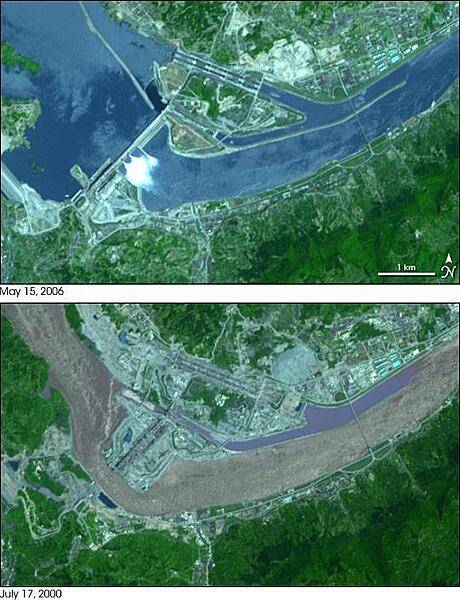
Construction of the Three Gorges Dam on the Yangtze River in central China. On 15 May 2006, Chinese engineers were pouring the last of the concrete to finish the construction of the massive dam, which is designed to provide flood control and to be the largest electricity-generating plant in the world. By 15 May 2006, the dam spanned the entire river, and a large reservoir had filled behind it to the northwest. White spray shoots through gates in the center portion of the dam. The former locks are much less prominent, and the new ones to the north appear as a linear arrangement of thin, blue rectangles. Photos courtesy of NASA.
Construction of the Three Gorges Dam on the Yangtze River in central China. On 15 May 2006, Chinese engineers were pouring the last of the concrete to finish the construction of the massive dam, which is designed to provide flood control and to be the largest electricity-generating plant in the world. By 15 May 2006, the dam spanned the entire river, and a large reservoir had filled behind it to the northwest. White spray shoots through gates in the center portion of the dam. The former locks are much less prominent, and the new ones to the north appear as a linear arrangement of thin, blue rectangles. Photos courtesy of NASA. • CIA World Factbook • 2020
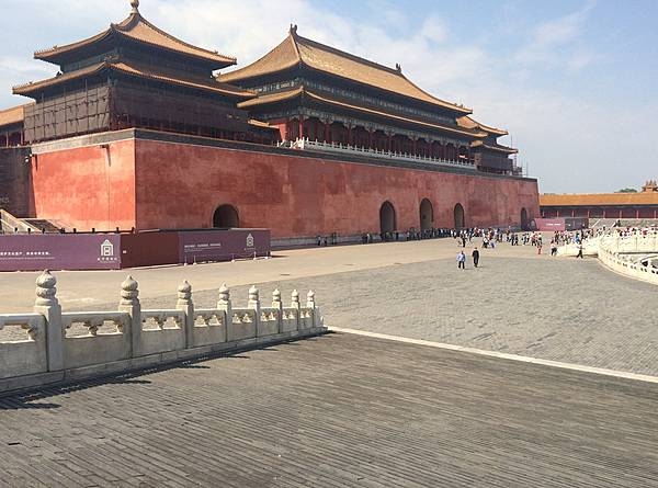
The Meridian Gate - the largest gate in the Forbidden City with five arches - is the southern entrance to the Forbidden City in Beijing. Built from 1406 to 1420, the Forbidden City was the Chinese imperial palace from the Ming Dynasty, which began in 1368, to the end of the Qing Dynasty in 1912.
The Meridian Gate - the largest gate in the Forbidden City with five arches - is the southern entrance to the Forbidden City in Beijing. Built from 1406 to 1420, the Forbidden City was the Chinese imperial palace from the Ming Dynasty, which began in 1368, to the end of the Qing Dynasty in 1912. • CIA World Factbook • 2020
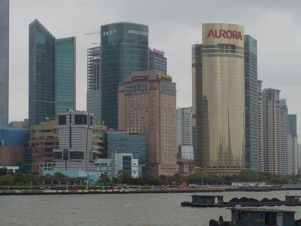
View of the Pudong area in Shanghai from across the Huongpu River. The Pudong is a rapidly developing business district in the city.
View of the Pudong area in Shanghai from across the Huongpu River. The Pudong is a rapidly developing business district in the city. • CIA World Factbook • 2020
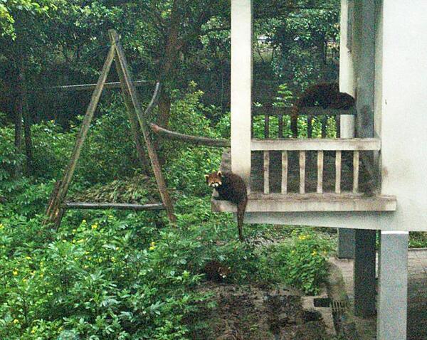
Lesser pandas at the Chongqing Zoo.
Lesser pandas at the Chongqing Zoo. • CIA World Factbook • 2020
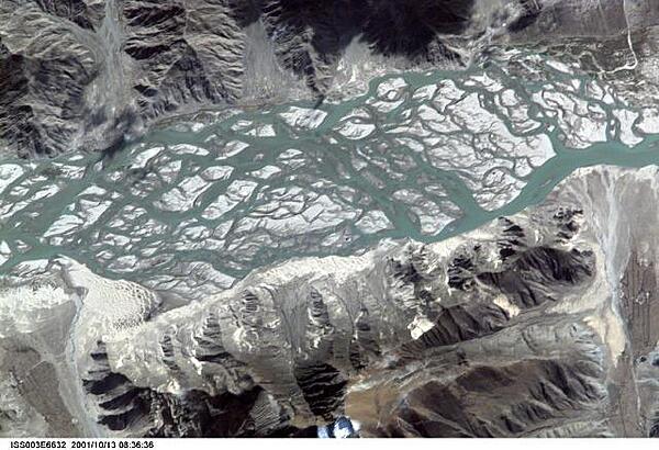
The Brahmaputra River carves a narrow west-east valley between the Tibetan Plateau to the north and the Himalaya Mountains to the south, as it rushes eastward for more than 1,500 km (940 mi) in southwestern China. This 15-km (9-mi) stretch is situated about 35 km (22 mi) south of the ancient Tibetan capital of Lhasa where the river flow becomes intricately braided as it works and reworks its way through extensive deposits of erosional material. Click on photo for higher resolution. Image courtesy of NASA.
The Brahmaputra River carves a narrow west-east valley between the Tibetan Plateau to the north and the Himalaya Mountains to the south, as it rushes eastward for more than 1,500 km (940 mi) in southwestern China. This 15-km (9-mi) stretch is situated about 35 km (22 mi) south of the ancient Tibetan capital of Lhasa where the river flow becomes intricately braided as it works and reworks its way through extensive deposits of erosional material. Click on photo for higher resolution. Image courtesy of NASA. • CIA World Factbook • 2020
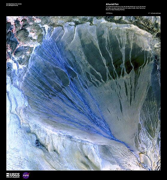
In this dramatic false-color satellite image, a vast alluvial fan blossoms across the Taklimakan Desert between the Kunlun and Altun mountains in Xinjiang Province. The left side of the fan in blue is the active side and displays glacial run-off from the Molcha River; the green side on the right consists of older stream paths no longer in use. Image courtesy of USGS.
In this dramatic false-color satellite image, a vast alluvial fan blossoms across the Taklimakan Desert between the Kunlun and Altun mountains in Xinjiang Province. The left side of the fan in blue is the active side and displays glacial run-off from the Molcha River; the green side on the right consists of older stream paths no longer in use. Image courtesy of USGS. • CIA World Factbook • 2020
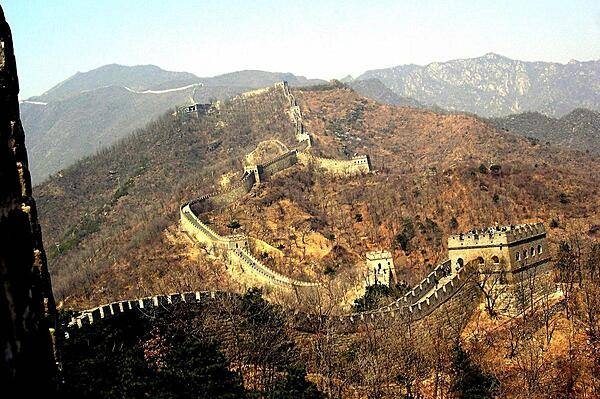
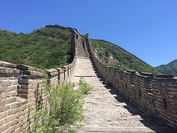
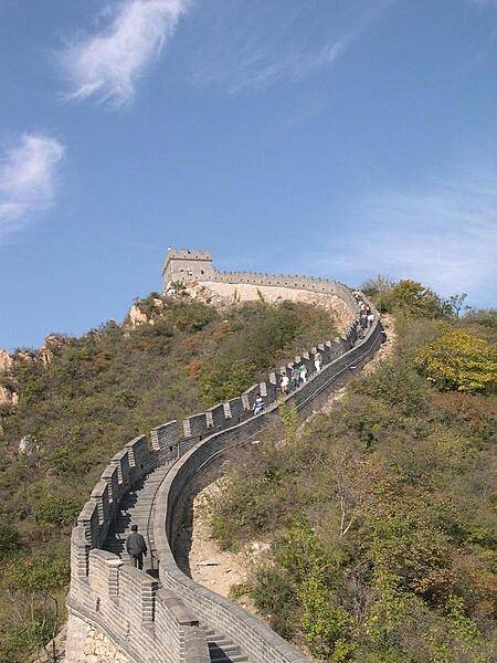
Multiple watchtowers along a section of the Great Wall.
Multiple watchtowers along a section of the Great Wall. • CIA World Factbook • 2020
The spillway of the Three Gorges Dam at Sandouping.
The spillway of the Three Gorges Dam at Sandouping. • CIA World Factbook • 2020
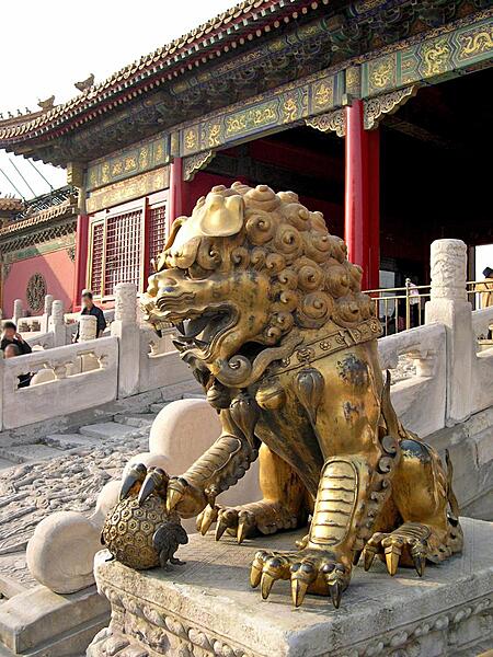
A gilded lion sits before the Palace of Tranquil Longevity in the Inner Court of the Hall of Supreme Harmony in the Forbidden City.
A gilded lion sits before the Palace of Tranquil Longevity in the Inner Court of the Hall of Supreme Harmony in the Forbidden City. • CIA World Factbook • 2020
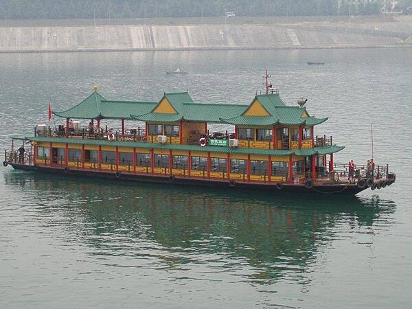
Tour boat on the Daning River, a tributary of the Yangtze River.
Tour boat on the Daning River, a tributary of the Yangtze River. • CIA World Factbook • 2020
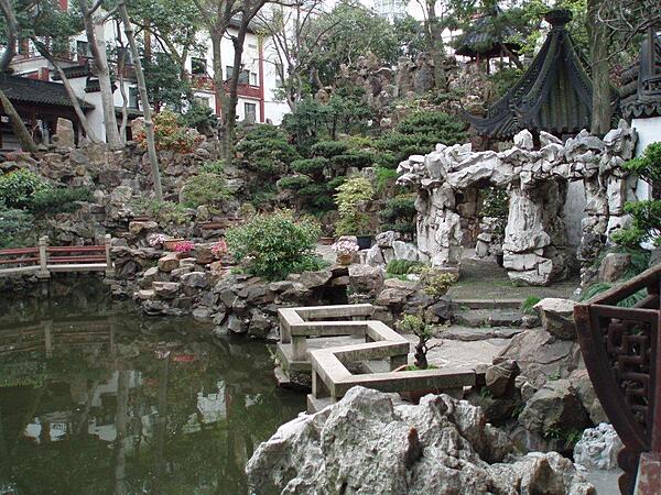
Yuyuan Garden in Shanghai, which dates to the Ming Dynasty (14th-17th centuries), contains two hectares (five acres) of delicate pavilions and winding paths.
Yuyuan Garden in Shanghai, which dates to the Ming Dynasty (14th-17th centuries), contains two hectares (five acres) of delicate pavilions and winding paths. • CIA World Factbook • 2020
CIA World Factbook • 2020
Imposing statue in the Shibaozhai Temple.
Imposing statue in the Shibaozhai Temple. • CIA World Factbook • 2020
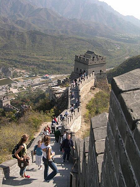
A walkway on top of the Great Wall leading to a fortification at Juyongguan Pass.
A walkway on top of the Great Wall leading to a fortification at Juyongguan Pass. • CIA World Factbook • 2020
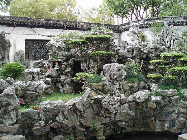
Yuyuan Garden in Shanghai dates to the Ming Dynasty (14th-17th centuries). Its two hectares (five acres) display a variety of sights including caves, grottoes, and a 14 m (46 ft) artificial mountain.
Yuyuan Garden in Shanghai dates to the Ming Dynasty (14th-17th centuries). Its two hectares (five acres) display a variety of sights including caves, grottoes, and a 14 m (46 ft) artificial mountain. • CIA World Factbook • 2020
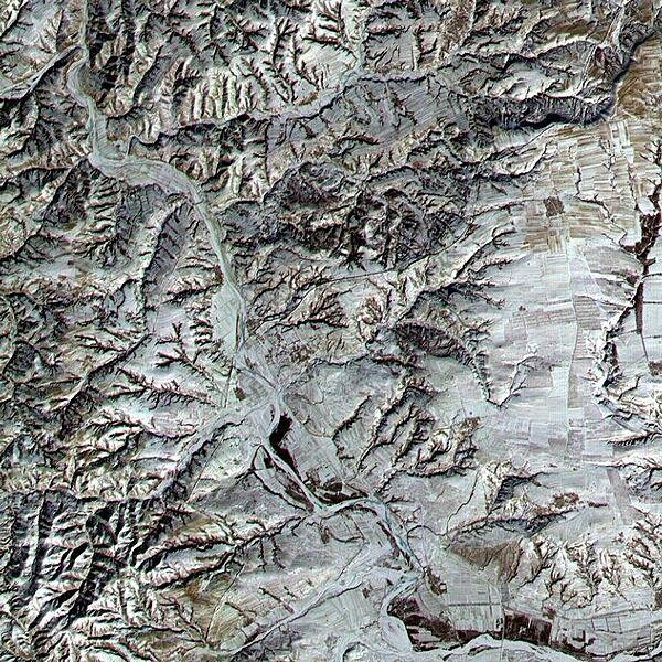
An area in northern Shanxi Province imaged on 9 January 2001. The low sun angle and light snow cover highlight a section of the Great Wall, visible as a black line snaking diagonally through the image from lower left to upper right. The Great Wall (actually a series of walls) is over 2,000 years old and was built over a period of 1,000 years. Stretching 8,850 km (5,500 mi) from Korea to the Gobi Desert, it was built to protect China from northern marauders. Click on photo for higher resolution. Image courtesy of NASA.
An area in northern Shanxi Province imaged on 9 January 2001. The low sun angle and light snow cover highlight a section of the Great Wall, visible as a black line snaking diagonally through the image from lower left to upper right. The Great Wall (actually a series of walls) is over 2,000 years old and was built over a period of 1,000 years. Stretching 8,850 km (5,500 mi) from Korea to the Gobi Desert, it was built to protect China from northern marauders. Click on photo for higher resolution. Image courtesy of NASA. • CIA World Factbook • 2020
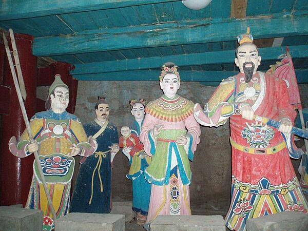
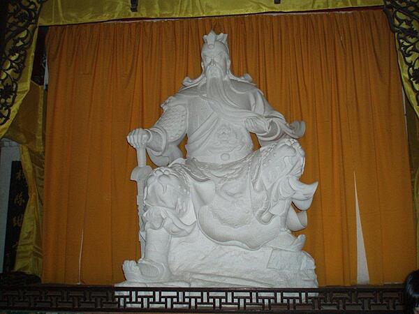
A lifelike group of figures on one of the landings in the pagoda.
A lifelike group of figures on one of the landings in the pagoda. • CIA World Factbook • 2020
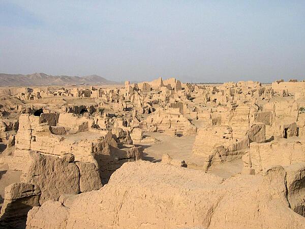
The ruins of Jiaohe in the Yarnaz Valley 10 km (6 mi) west of Turpan. An important site along the Silk Road, the city was situated on an islet in the middle of a river, which served as a natural barrier and enabled the city to be built without walls. From 108 B.C. to A.D. 450 it was the capital of the Anterior Jushi Kingdom; later, it became a prefecture capital until it was destroyed by the Mongols in the 13th century.
The ruins of Jiaohe in the Yarnaz Valley 10 km (6 mi) west of Turpan. An important site along the Silk Road, the city was situated on an islet in the middle of a river, which served as a natural barrier and enabled the city to be built without walls. From 108 B.C. to A.D. 450 it was the capital of the Anterior Jushi Kingdom; later, it became a prefecture capital until it was destroyed by the Mongols in the 13th century. • CIA World Factbook • 2020
Entranceway to the Shibaozhai complex via a swinging foot bridge.
Entranceway to the Shibaozhai complex via a swinging foot bridge. • CIA World Factbook • 2020
The Gezhouba Dam locks on the Yangtze River. Here the locks have been flooded.
The Gezhouba Dam locks on the Yangtze River. Here the locks have been flooded. • CIA World Factbook • 2020
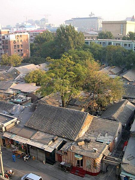
Hutongs are traditional Chinese neighborhoods composed of narrow streets or alleys, running from siheyuan, or courtyard residences. Since the mid-20th century, these types of neighborhoods have become increasingly rare. This is a hutong in Beijing.
Hutongs are traditional Chinese neighborhoods composed of narrow streets or alleys, running from siheyuan, or courtyard residences. Since the mid-20th century, these types of neighborhoods have become increasingly rare. This is a hutong in Beijing. • CIA World Factbook • 2020
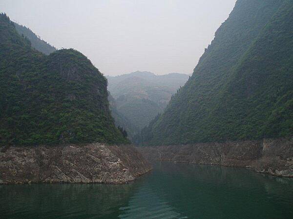
The Dragon Gate Gorge is one of the Three Lesser Gorges near Wushan on the Daning River, a tributary of the Yangtze River.
The Dragon Gate Gorge is one of the Three Lesser Gorges near Wushan on the Daning River, a tributary of the Yangtze River. • CIA World Factbook • 2020
Built in 1420, the Gate of Heavenly Peace leads to the former Imperial City. The gate has been reconstructed several times, most recently in 1969-70.
Built in 1420, the Gate of Heavenly Peace leads to the former Imperial City. The gate has been reconstructed several times, most recently in 1969-70. • CIA World Factbook • 2020
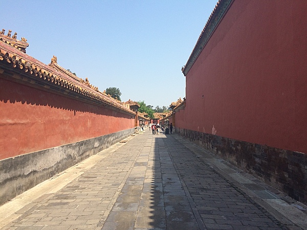
An imposing walkway gives an idea of the immensity of the Forbidden City in Beijing.
An imposing walkway gives an idea of the immensity of the Forbidden City in Beijing. • CIA World Factbook • 2020
CIA World Factbook • 2020
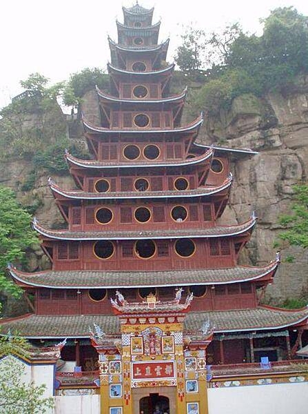
The 12-story wooden pagoda at Shibaozhai. The first nine-stories were constructed in the 1819; three more stories were added in 1956.
The 12-story wooden pagoda at Shibaozhai. The first nine-stories were constructed in the 1819; three more stories were added in 1956. • CIA World Factbook • 2020
Wushan on the Yangtze is an example of a major city flooded by the rising waters of the Three Gorges Dam and moved to higher ground.
Wushan on the Yangtze is an example of a major city flooded by the rising waters of the Three Gorges Dam and moved to higher ground. • CIA World Factbook • 2020
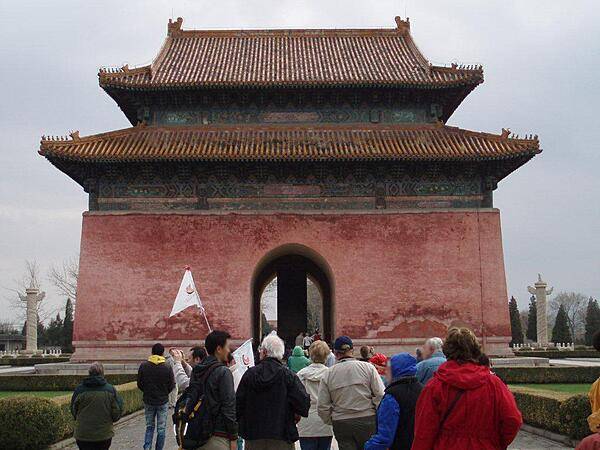
The Ming Dynasty Tombs are located some 50 km (30 mi) north of Beijing. The archway leading to the Sacred Way and the tombs dates to 1540; it is the earliest and largest stone archway in China.
The Ming Dynasty Tombs are located some 50 km (30 mi) north of Beijing. The archway leading to the Sacred Way and the tombs dates to 1540; it is the earliest and largest stone archway in China. • CIA World Factbook • 2020
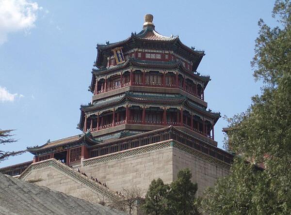
The Tower of Buddhist Incense at the Summer Palace in Beijing.
The Tower of Buddhist Incense at the Summer Palace in Beijing. • CIA World Factbook • 2020
The Huanghuacheng (Lakeside) section of the Great Wall derives its name from the nearby man-made reservoir lakes. Unlike the main tourist sections of the Great Wall at Mutianyu and Badaling, the Lakeside Great Wall draws a far smaller number of tourists. The section features appealing sights including submerged parts of the Great Wall under the lake water and a sweeping view after a steep hike to a high guard tower.
The Huanghuacheng (Lakeside) section of the Great Wall derives its name from the nearby man-made reservoir lakes. Unlike the main tourist sections of the Great Wall at Mutianyu and Badaling, the Lakeside Great Wall draws a far smaller number of tourists. The section features appealing sights including submerged parts of the Great Wall under the lake water and a sweeping view after a steep hike to a high guard tower. • CIA World Factbook • 2020
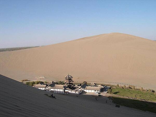
Crescent Moon Lake is an oasis in the Singing Sands Mountains, six kilometers south of Dunhuang. The lake gets its name from its shape. Activities in this area include camel riding, dune paragliding, and sand sledding. Most tourists visit in the evening to avoid the heat.
Crescent Moon Lake is an oasis in the Singing Sands Mountains, six kilometers south of Dunhuang. The lake gets its name from its shape. Activities in this area include camel riding, dune paragliding, and sand sledding. Most tourists visit in the evening to avoid the heat. • CIA World Factbook • 2020
The Huxinting Teahouse (Mid-Lake Pavilion Teahouse) in Shanghai was built as a pavilion in the middle of an artificial lake in 1784, but converted to a teahouse in 1855. It can accommodate 200 patrons at a time and is visited by people from all over the world.
The Huxinting Teahouse (Mid-Lake Pavilion Teahouse) in Shanghai was built as a pavilion in the middle of an artificial lake in 1784, but converted to a teahouse in 1855. It can accommodate 200 patrons at a time and is visited by people from all over the world. • CIA World Factbook • 2020
The Summer Palace is a vast ensemble of lakes, gardens, and palaces in Beijing. It was an imperial garden in the Qing dynasty (1644 to 1912). UNESCO added the Summer Palace to its World Heritage List in 1998. The Stone Boat, a lakeside pavilion on the grounds of the Summer Palace in Beijing, is 36 m long; it replaces an original wooden boat that burnt in1860. The new structure is also wooden and sits on a base of large stone blocks. The wood is painted to imitate marble and displays an imitation western-style paddle wheel on both sides.
The Summer Palace is a vast ensemble of lakes, gardens, and palaces in Beijing. It was an imperial garden in the Qing dynasty (1644 to 1912). UNESCO added the Summer Palace to its World Heritage List in 1998. The Stone Boat, a lakeside pavilion on the grounds of the Summer Palace in Beijing, is 36 m long; it replaces an original wooden boat that burnt in1860. The new structure is also wooden and sits on a base of large stone blocks. The wood is painted to imitate marble and displays an imitation western-style paddle wheel on both sides. • CIA World Factbook • 2020
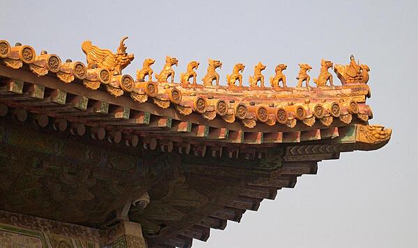
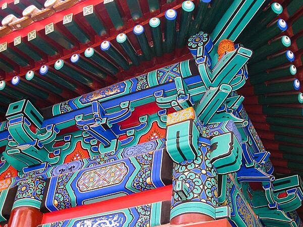
Roof charms decorate a building in the Forbidden City. The more important the structure, the more decorative charms were used - in this case eleven: a man riding a phoenix heads a procession of nine mythical beasts that are followed by an imperial dragon.
Roof charms decorate a building in the Forbidden City. The more important the structure, the more decorative charms were used - in this case eleven: a man riding a phoenix heads a procession of nine mythical beasts that are followed by an imperial dragon. • CIA World Factbook • 2020
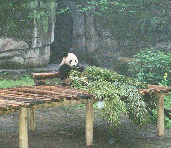
Panda munching bamboo stalks at the Chongqing Zoo.
Panda munching bamboo stalks at the Chongqing Zoo. • CIA World Factbook • 2020
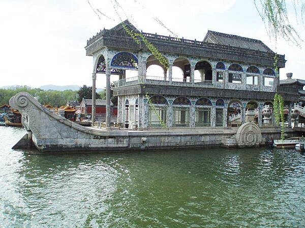
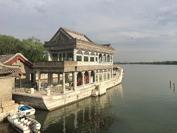
The Marble Boat at the Summer Palace in Beijing. The wooden structure was built in 1755 on a stone base and rebuilt in 1893 as a wooden lakeside pavilion in the shape of a paddle steamer. The structure is faux painted to imitate marble.
The Marble Boat at the Summer Palace in Beijing. The wooden structure was built in 1755 on a stone base and rebuilt in 1893 as a wooden lakeside pavilion in the shape of a paddle steamer. The structure is faux painted to imitate marble. • CIA World Factbook • 2020
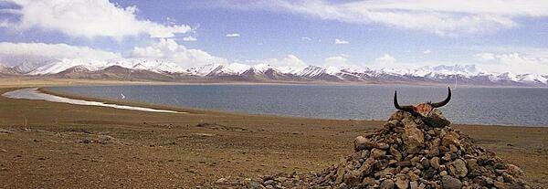
Namco Lake, meaning Heavenly Lake, is north of Lhasa in Tibet. It is the highest and largest salt water lake in the world (4,718 m (15,475 ft) above sea level; 1,940 sq km (750 sq mi) in area).
Namco Lake, meaning Heavenly Lake, is north of Lhasa in Tibet. It is the highest and largest salt water lake in the world (4,718 m (15,475 ft) above sea level; 1,940 sq km (750 sq mi) in area). • CIA World Factbook • 2020
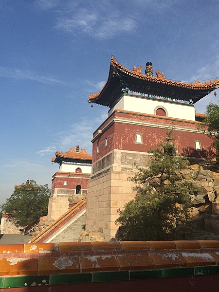
Another view of a gate tower at the Summer Palace in Beijing.
Another view of a gate tower at the Summer Palace in Beijing. • CIA World Factbook • 2020
![An oblique view of the Himalayas as seen from the International Space Station, 360 km (225 mi) up. The view looks south over the Tibetan Plateau and features Mt. Everest and Makalu (the 1st and 5th highest mountains in the world respectively). The image almost looks like a picture taken from an airplane until you remember that the summits of Makalu [left (8,462 m: 27,765 ft)] and Everest [center (8,850 m; 29,035 ft)] are at the heights typically flown by commercial aircraft, and could never be seen this way from an airplane. Click on photo for higher resolution. Image courtesy of NASA.](https://ciafactbookmedia.blob.core.windows.net/cia-factbook-media/cia-factbook-2020/photos/CN/2b1452a4_CH_013_large.jpg)
An oblique view of the Himalayas as seen from the International Space Station, 360 km (225 mi) up. The view looks south over the Tibetan Plateau and features Mt. Everest and Makalu (the 1st and 5th highest mountains in the world respectively). The image almost looks like a picture taken from an airplane until you remember that the summits of Makalu [left (8,462 m: 27,765 ft)] and Everest [center (8,850 m; 29,035 ft)] are at the heights typically flown by commercial aircraft, and could never be seen this way from an airplane. Click on photo for higher resolution. Image courtesy of NASA.
An oblique view of the Himalayas as seen from the International Space Station, 360 km (225 mi) up. The view looks south over the Tibetan Plateau and features Mt. Everest and Makalu (the 1st and 5th highest mountains in the world respectively). The image almost looks like a picture taken from an airplane until you remember that the summits of Makalu [left (8,462 m: 27,765 ft)] and Everest [center (8,850 m; 29,035 ft)] are at the heights typically flown by commercial aircraft, and could never be seen this way from an airplane. Click on photo for higher resolution. Image courtesy of NASA. • CIA World Factbook • 2020
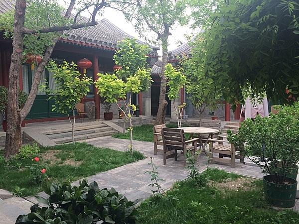
A small garden inside a residence in Beijing.
A small garden inside a residence in Beijing. • CIA World Factbook • 2020
Area comparison map
Area comparison map • CIA World Factbook • 2020
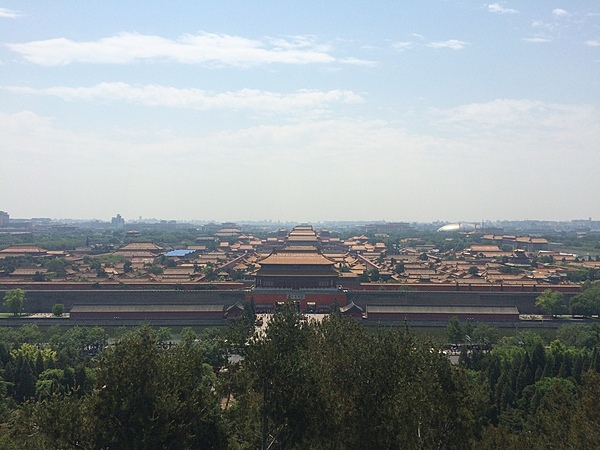
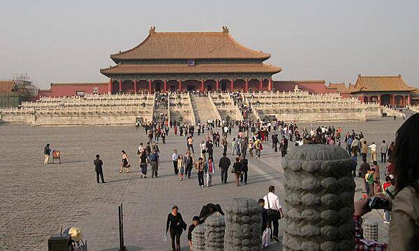
The Forbidden City in Beijing viewed from Jingshan Hill.
The Forbidden City in Beijing viewed from Jingshan Hill. • CIA World Factbook • 2020
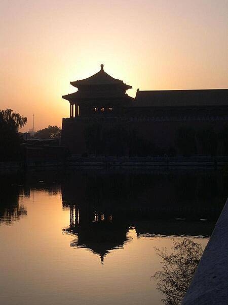
A section of the Forbidden City in Beijing at sunset. Built between 1406 and 1420, the palace complex served as the Chinese imperial palace until 1912. Today it is the Palace Museum showing artifacts from the Ming to the Qing Dynasties (14th to 20th centuries). The complex - on the World Heritage Site list since 1987 - consists of 980 surviving buildings on 72 hectares (178 acres) and is the largest collection of preserved ancient wooden structures in the world.
A section of the Forbidden City in Beijing at sunset. Built between 1406 and 1420, the palace complex served as the Chinese imperial palace until 1912. Today it is the Palace Museum showing artifacts from the Ming to the Qing Dynasties (14th to 20th centuries). The complex - on the World Heritage Site list since 1987 - consists of 980 surviving buildings on 72 hectares (178 acres) and is the largest collection of preserved ancient wooden structures in the world. • CIA World Factbook • 2020
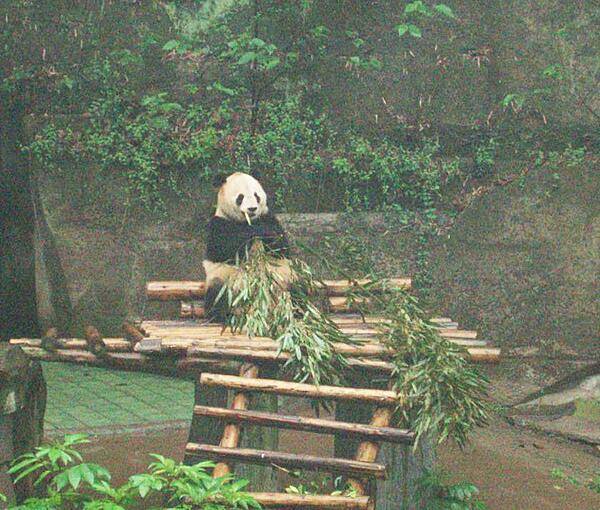
Panda munching bamboo stalks at the Chongqing Zoo.
Panda munching bamboo stalks at the Chongqing Zoo. • CIA World Factbook • 2020
A crenellated walkway on top of the Great Wall. The Wall stretched for many thousands of miles linking fortresses. Signal towers were used for communication.
A crenellated walkway on top of the Great Wall. The Wall stretched for many thousands of miles linking fortresses. Signal towers were used for communication. • CIA World Factbook • 2020
Media source: CIA World Factbook (2020) — Public Domain