›››
Costa Rica
Costa Rica
Population
5.1M
Rank #126Source: World Bank
Capital
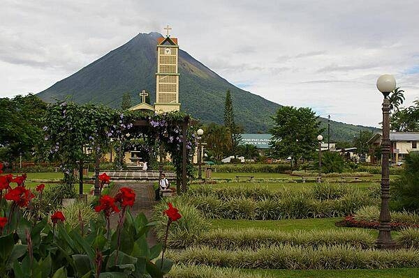
San Jose
Source: REST Countries
Region
Americas
Latin America & Caribbean
Source: REST Countries
GDP (Nominal)
$95.35B
Rank #73Source: World Bank
Land Area
51.1K km²
Rank #127Source: REST Countries
Life Expectancy
80.799 yrs
Source: World Bank
Historical Trends
Population Trend (5-Year)
Source: World Bank
GDP Trend (5-Year, Nominal USD)
Source: World Bank
Geography
Area: 51,100 km²
Landlocked: No
Independent: Yes
Climate: tropical
Terrain: sand and coral reefs and islands (cays)
Elevation: lowest point: Pacific Ocean 0 m highest point: unnamed location on Cato Island 9 m
Natural Hazards: occasional tropical cyclones
Environmental Issues: no permanent freshwater resources; damaging activities include coral mining, destructive fishing practices (overfishing, blast fishing)
Land Use: agricultural land: 0% (2011 est.) forest: 0% (2011 est.) other: 100% (2011 est.)
Geography Note: important nesting area for birds and turtles
Natural Resources
fish
People & Society
Fertility Rate
1.33
Population
5.1M
Ethnic Groups
White or Mestizo (83.6%)Mulatto (6.7%)Indigenous (2.4%)Black of African descent (1.1%)other (1.1%)none (2.9%)unspecified (2.2%)
Religions
Roman Catholic (71.8%)Evangelical and Pentecostal (12.3%)other Protestant (2.6%)Jehovah's Witness (0.5%)other (2.4%)none (10.4%)
Economy
GDP per Capita
$18,587.153
GDP per Capita PPP
31,106.764
(2024)
(2024)
GNI per Capita
15,620
(2024)
(2024)
Gini Index
45.8
(2024)
(2024)
Unemployment
6.936%
(2024)
(2024)
Inflation
0.525%
(2023)
(2023)
Public Debt
Not Available
Energy
Electricity Access
100%
(2023)
(2023)
Renewable Energy
34.2%
(2021)
(2021)
CO₂ Emissions
8.376 Mt
(2024)
(2024)
Energy Intensity
1.91 MJ/$
(2022)
(2022)
Renewable Electricity
99.367%
(2021)
(2021)
Environment
Forest Coverage
60.399% of land
(2023)
(2023)
Communications
Internet Users
85.395%
(2023)
(2023)
Mobile Penetration
145.789%
(2023)
(2023)
Broadband Subscribers
22.523%
(2023)
(2023)
Transportation
Air Transport Freight
7.176 M ton-km
(2023)
(2023)
Container Port Traffic
1,594,323 TEU
(2022)
(2022)
Airports
15,698
Rail Lines
N/A
Roads Total
45,898 km(©IRF)
Military
Military Forces
no regular military forces; Ministry of Public Security commands the Public Forces of Costa Rica, which includes the Public Force (National Police), Anti-Drug Police, and National Coast Guard Service...
Personnel Strength
the Public Forces of Costa Rica have approximately 12,000 personnel
Military Expenditure (USD)
$0.00B
Equipment & Inventories
the Public Forces' inventory includes mostly second-hand US equipment; since 2000, the only reported major equipment deliveries were from the US (light helicopters in 2012 and 2014 and second-hand...
Education
Pre-Primary Enrollment
95.235%
(2021)
(2021)
Primary Enrollment
106.157%
(2023)
(2023)
Secondary Enrollment
125.51%
(2023)
(2023)
Tertiary Enrollment
55.02%
(2019)
(2019)
Education Spending
6.248% of GDP
(2021)
(2021)
Adult Literacy Rate
97.41%
(2011)
(2011)
Pupil-Teacher Ratio
12.205:1
(2018)
(2018)
Health
Physicians per 1,000
2.687
(2022)
(2022)
Safe Water Access
99.815%
(2024)
(2024)
Safe Drinking Water
80.5%
(2024)
(2024)
Under-5 Mortality
10.5 per 1,000
(2023)
(2023)
Maternal Mortality (World Bank)
23.496 per 100,000
(2021)
(2021)
Hospital Beds per 1,000
81.506
(2021)
(2021)
UHC Coverage Index
84
(2023)
(2023)
Measles Immunization
99%
(2024)
(2024)
Social Indicators
Extreme Poverty Rate
1.3%
(2024)
(2024)
Food Insecurity
2.5%
(2023)
(2023)
Youth NEET Rate
20.673%
(2024)
(2024)
Governance
Women in Government
49.123%
(2024)
(2024)
Voice & Accountability
1.07
(Strong)
(2023)
(Strong)
(2023)
Political Stability
0.98
(Above Average)
(2023)
(Above Average)
(2023)
Government Effectiveness
0.26
(Above Average)
(2023)
(Above Average)
(2023)
Regulatory Quality
0.54
(Above Average)
(2023)
(Above Average)
(2023)
Rule of Law
0.39
(Above Average)
(2023)
(Above Average)
(2023)
Control of Corruption
0.65
(Above Average)
(2023)
(Above Average)
(2023)
Government
Government Type
presidential republic
Legal System
the common law legal system of Australia applies where applicable
Executive Branch
chief of state: President Carlos ALVARADO Quesada (since 8 May 2018); First Vice President Epsy CAMPBELL Barr (since 8 May 2018); Second Vice President Marvin RODRIGUEZ Cordero (since 8 May 2018);...
Legislative Branch
description: unicameral Legislative Assembly or Asamblea Legislativa (57 seats; members directly elected in multi-seat constituencies - corresponding to the country's 7 provinces - by closed list...
Judicial Branch
highest courts: Supreme Court of Justice (consists of 22 judges organized into 3 cassation chambers each with 5 judges and the Constitutional Chamber with 7 judges) judge selection and term of...
National Symbols
Flag Description
the flag of Australia is used
National Symbols
yiguirro (clay-colored robin); national colors: blue, white, red
National Anthem
name: "Himno Nacional de Costa Rica" (National Anthem of Costa Rica) lyrics/music: Jose Maria ZELEDON Brenes/Manuel Maria GUTIERREZ note: adopted 1949; the anthem's music was originally written for...
Safety
Homicide Rate
17.745 per 100,000
(2023)
(2023)
Travel Information
Language(s): Spanish
Currency: CRC (₡)
Timezone(s): UTC-06:00
Landlocked: No
Independent: Yes
Driving Side: Right
Calling Code: +506
Car Sign: CR
Week Starts: Monday
Photos
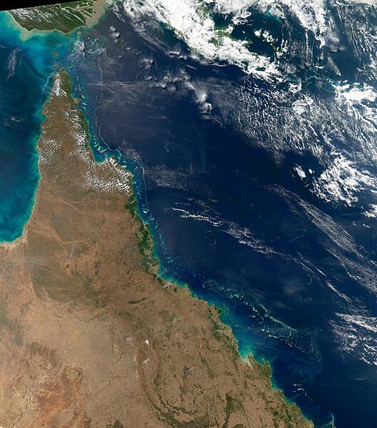
This view of the Queensland coast of northeast Australia taken by the Aqua satellite vividly shows the many offshore reefs that together form the Great Barrier Reef. The various white specks in the deeper blue waters of the Coral Sea to the east are some of the reefs, cays, and islets that make up the Coral Sea Islands. Image courtesy of NASA.
This view of the Queensland coast of northeast Australia taken by the Aqua satellite vividly shows the many offshore reefs that together form the Great Barrier Reef. The various white specks in the deeper blue waters of the Coral Sea to the east are some of the reefs, cays, and islets that make up the Coral Sea Islands. Image courtesy of NASA. • CIA World Factbook • 2020
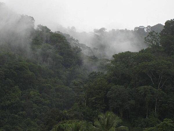
Mist rising over the rainforest near Gulfito on the Pacific coast near the border of Panama. This region is one of the wettest spots in the world.
Mist rising over the rainforest near Gulfito on the Pacific coast near the border of Panama. This region is one of the wettest spots in the world. • CIA World Factbook • 2020
CIA World Factbook • 2020
CIA World Factbook • 2020
CIA World Factbook • 2020
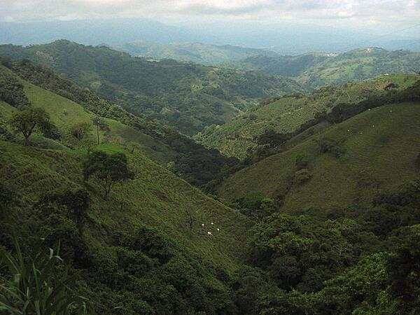
Mountainous countryside along the road to the capital of San Jose.
Mountainous countryside along the road to the capital of San Jose. • CIA World Factbook • 2020
14 photos available
View All Photos→Data sources: World Bank, UN Data • Updated daily •Learn about our data