›››
Egypt, Arab Rep. — Media Gallery
150 items available (flags, maps, photos)
Photos
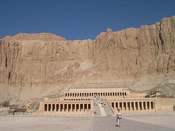
Djeser-Djeseru (the Holy of Holies) is Pharaoh Hatshepsut's mortuary temple in the temple complex of Deir el-Bahri near Luxor. Pharaohs of the 11th and 18th Dynasty's built their temples here. Hatshepsut's temple (the best preserved) was built into the cliff side on top of a series of colonnaded terraces in the classical Theban form; it includes a pylon, courts, a hypostyle hall, sun court, chapel, and sanctuary.
Djeser-Djeseru (the Holy of Holies) is Pharaoh Hatshepsut's mortuary temple in the temple complex of Deir el-Bahri near Luxor. Pharaohs of the 11th and 18th Dynasty's built their temples here. Hatshepsut's temple (the best preserved) was built into the cliff side on top of a series of colonnaded terraces in the classical Theban form; it includes a pylon, courts, a hypostyle hall, sun court, chapel, and sanctuary. • CIA World Factbook • 2020
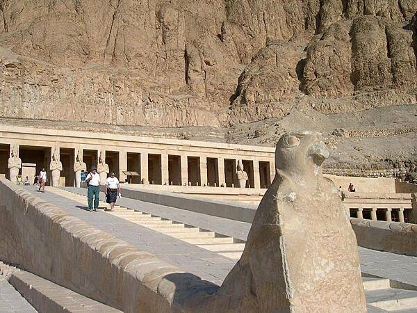
Stairway and ramp leading up to Hatshepsut's temple at Deir el-Bahri. Hatshepsut lived between 1508-1458 B.C. She was the eldest daughter of Pharaoh Thutmose I and married her half brother, Thutmose II. When he died, she became pharaoh. Her 22-year reign is known for bringing prosperity to her subjects.
Stairway and ramp leading up to Hatshepsut's temple at Deir el-Bahri. Hatshepsut lived between 1508-1458 B.C. She was the eldest daughter of Pharaoh Thutmose I and married her half brother, Thutmose II. When he died, she became pharaoh. Her 22-year reign is known for bringing prosperity to her subjects. • CIA World Factbook • 2020
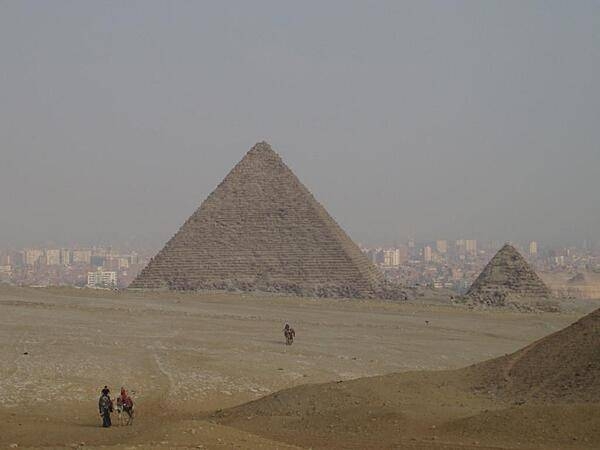
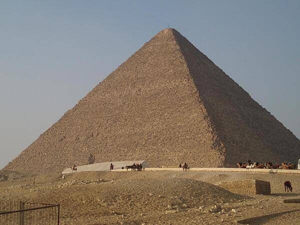
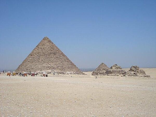
The Pyramid of Menkaure is the smallest of the three kings' pyramids on the Giza Plateau. The city of Cairo appears in the background.
The Pyramid of Menkaure is the smallest of the three kings' pyramids on the Giza Plateau. The city of Cairo appears in the background. • CIA World Factbook • 2020
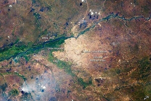
Juba, a port city on the White Nile, is the capital of South Sudan and one of the fastest growing cities in the world. Juba's population is estimated to be roughly 350,000 to 400,000. The city has doubled in size since 2005, when a peace agreement ended the civil war in Sudan. Both hopeful immigrants and returning residents have created the population surge. The city was a central point for humanitarian aid, and the operations base for the UN and NGOs during the Sudanese conflicts. During the fighting, city infrastructure and main transportation arteries suffered heavy damage. The city is still surrounded by army camps and squatter settlements (labeled "informal built-up areas" in the image). They appear as muted gray areas extending outward from the center of the city. The city also hosts the Juba Game Reserve, a protected area of savannah and woodlands that is home to key bird species. Since independence, a variety of countries and international organizations have helped rebuild Juba's roads, railroads, and airport. Unfortunately, South Sudan continues to experience local wars with a variety of armed groups, including on-going conflicts with Sudan over oil-rich territories. Image courtesy of NASA.
Juba, a port city on the White Nile, is the capital of South Sudan and one of the fastest growing cities in the world. Juba's population is estimated to be roughly 350,000 to 400,000. The city has doubled in size since 2005, when a peace agreement ended the civil war in Sudan. Both hopeful immigrants and returning residents have created the population surge. The city was a central point for humanitarian aid, and the operations base for the UN and NGOs during the Sudanese conflicts. During the fighting, city infrastructure and main transportation arteries suffered heavy damage. The city is still surrounded by army camps and squatter settlements (labeled "informal built-up areas" in the image). They appear as muted gray areas extending outward from the center of the city. The city also hosts the Juba Game Reserve, a protected area of savannah and woodlands that is home to key bird species. Since independence, a variety of countries and international organizations have helped rebuild Juba's roads, railroads, and airport. Unfortunately, South Sudan continues to experience local wars with a variety of armed groups, including on-going conflicts with Sudan over oil-rich territories. Image courtesy of NASA. • CIA World Factbook • 2020
Birth House at the Temple of Hathor at Dendera. A birth house or "mammisi" was associated with the nativity of a god. The birth house at Dendera was constructed mainly by the Roman emperor Trajan, who ruled from A.D. 98 to 117.
Birth House at the Temple of Hathor at Dendera. A birth house or "mammisi" was associated with the nativity of a god. The birth house at Dendera was constructed mainly by the Roman emperor Trajan, who ruled from A.D. 98 to 117. • CIA World Factbook • 2020

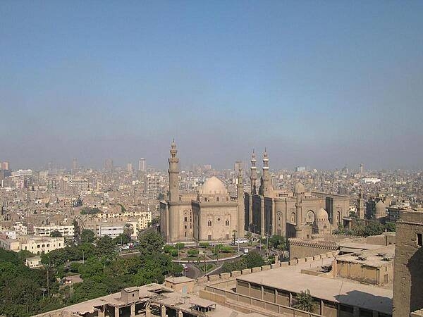
The Sultan Hassan and Ar-Rifai Mosques as seen from the Citadel with Cairo in the background. The Sultan Hassan Mosque and Madrasah (religious school) is a masterpiece of Mamluk architecture that was begun in 1356 and completed in 1363. It contains the burial chamber of the Sultan's two sons and is featured on the Egyptian hundred-pound note. The Ar-Rifai Mosque was built between 1869 and 1912. It houses the tomb of King Farouk, Egypt's last reigning monarch, and other members of the Egyptian royal family, as well as the tomb of the last shah of Iran.
The Sultan Hassan and Ar-Rifai Mosques as seen from the Citadel with Cairo in the background. The Sultan Hassan Mosque and Madrasah (religious school) is a masterpiece of Mamluk architecture that was begun in 1356 and completed in 1363. It contains the burial chamber of the Sultan's two sons and is featured on the Egyptian hundred-pound note. The Ar-Rifai Mosque was built between 1869 and 1912. It houses the tomb of King Farouk, Egypt's last reigning monarch, and other members of the Egyptian royal family, as well as the tomb of the last shah of Iran. • CIA World Factbook • 2020
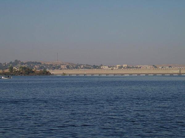
The Aswan High Dam was completed in 1971 with the assistance of the Soviet Union. The body of water behind it, Lake Nasser, can hold up to 210,000 billion cubic yards of water. The dam doubled Egypt's power generating capabilities.
The Aswan High Dam was completed in 1971 with the assistance of the Soviet Union. The body of water behind it, Lake Nasser, can hold up to 210,000 billion cubic yards of water. The dam doubled Egypt's power generating capabilities. • CIA World Factbook • 2020
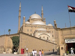
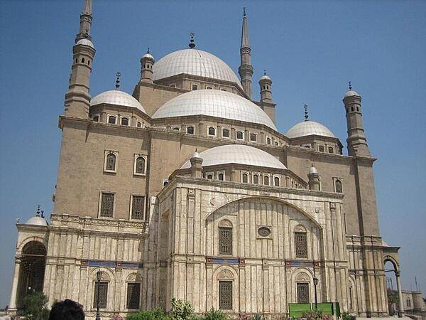
Built in the style of the Ottomans, the Mosque of Muhammad Ali was erected by its eponymous benefactor between 1830 and 1848 in memory of Tusun Pasha, Muhammad's eldest son who died in 1816. The mosque is located in the Citadel of Cairo; Muhammad Ali is buried in the mosque's courtyard.
Built in the style of the Ottomans, the Mosque of Muhammad Ali was erected by its eponymous benefactor between 1830 and 1848 in memory of Tusun Pasha, Muhammad's eldest son who died in 1816. The mosque is located in the Citadel of Cairo; Muhammad Ali is buried in the mosque's courtyard. • CIA World Factbook • 2020
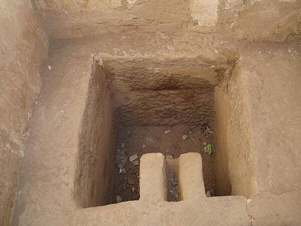
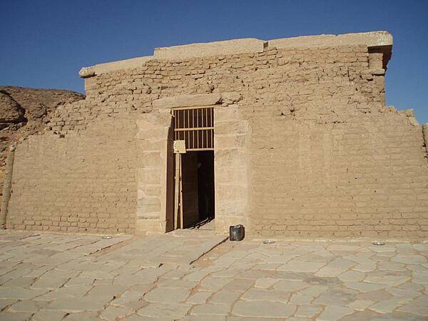
The pharaoh's toilet at the Mortuary Temple of Ramses III at Medinet Habu.
The pharaoh's toilet at the Mortuary Temple of Ramses III at Medinet Habu. • CIA World Factbook • 2020
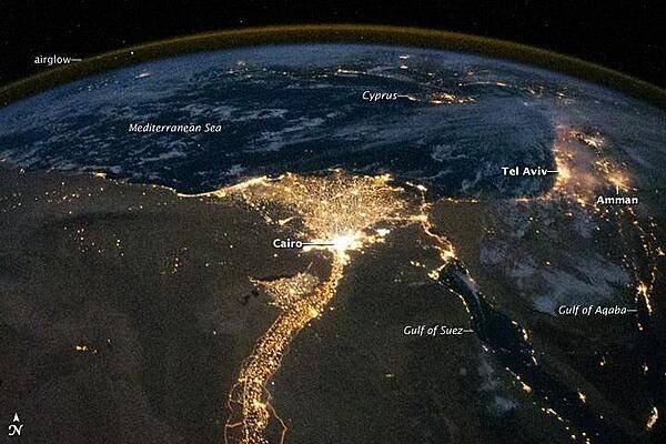
One of the fascinating aspects of viewing Earth at night is how well the lights show the distribution of people. In this view of Egypt, we see a population almost completely concentrated along the Nile Valley, just a small percentage of the country's land area. The Nile River and its delta look like a brilliant, long-stemmed flower in this astronaut photograph of the southeastern Mediterranean Sea. The Cairo metropolitan area forms a particularly bright base of the flower. The smaller cities and towns within the Nile Delta tend to be hard to see amidst the dense agricultural vegetation during the day. However, these settled areas and the connecting roads between them become clearly visible at night. Likewise, infrastructure and urbanized regions along the Nile River also become apparent. Another brightly lit region is visible along the eastern coastline of the Mediterranean, the Tel-Aviv metropolitan area in Israel (image right). To the east of Tel-Aviv lies Amman, Jordan. The two major water bodies that define the western and eastern coastlines of the Sinai Peninsula, the Gulf of Suez and the Gulf of Aqaba, are outlined by lights along their coastlines (image lower right). The city lights of Paphos, Limassol, Larnaca, and Nicosia are visible on the island of Cyprus (image top). Scattered blue-grey clouds cover the Mediterranean Sea and the Sinai, while much of northeastern Africa is cloud-free. The thin yellow-brown band tracing the Earth's curvature at image top is airglow, a faint band of light emission that results from the interaction of atmospheric atoms and molecules with solar radiation at approximately 100 km (60 mi) altitude. Photo courtesy of NASA.
One of the fascinating aspects of viewing Earth at night is how well the lights show the distribution of people. In this view of Egypt, we see a population almost completely concentrated along the Nile Valley, just a small percentage of the country's land area.
The Nile River and its delta look like a brilliant, long-stemmed flower in this astronaut photograph of the southeastern Mediterranean Sea. The Cairo metropolitan area forms a particularly bright base of the flower. The smaller cities and towns within the Nile Delta tend to be hard to see amidst the dense agricultural vegetation during the day. However, these settled areas and the connecting roads between them become clearly visible at night. Likewise, infrastructure and urbanized regions along the Nile River also become apparent.
Another brightly lit region is visible along the eastern coastline of the Mediterranean, the Tel-Aviv metropolitan area in Israel (image right). To the east of Tel-Aviv lies Amman, Jordan. The two major water bodies that define the western and eastern coastlines of the Sinai Peninsula, the Gulf of Suez and the Gulf of Aqaba, are outlined by lights along their coastlines (image lower right). The city lights of Paphos, Limassol, Larnaca, and Nicosia are visible on the island of Cyprus (image top).
Scattered blue-grey clouds cover the Mediterranean Sea and the Sinai, while much of northeastern Africa is cloud-free. The thin yellow-brown band tracing the Earth's curvature at image top is airglow, a faint band of light emission that results from the interaction of atmospheric atoms and molecules with solar radiation at approximately 100 km (60 mi) altitude. Photo courtesy of NASA. • CIA World Factbook • 2020
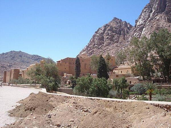
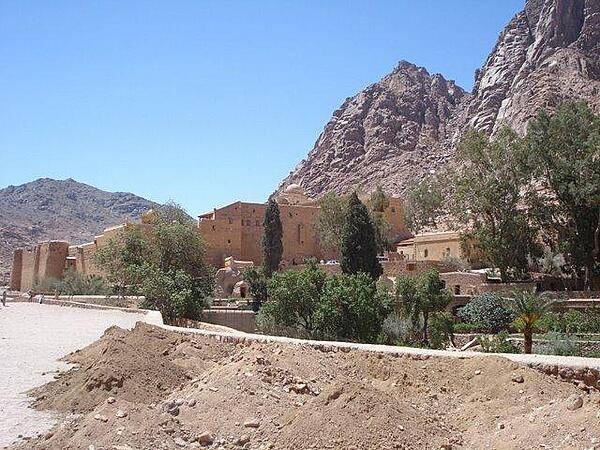
The Sinai Monastery of St. Catherine's located on the reputed site of the burning bush seen by Moses in the Old Testament.
The Sinai Monastery of St. Catherine's located on the reputed site of the burning bush seen by Moses in the Old Testament. • CIA World Factbook • 2020

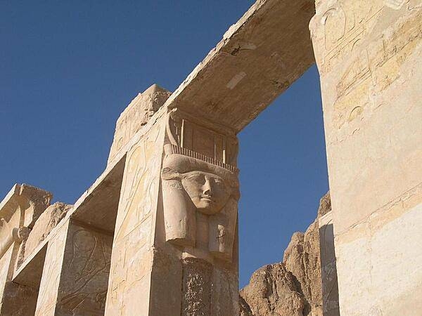
Head of the goddess Hathor on one of the colonnades at Djeser-Djeseru, Pharaoh Hatshepsut's mortuary temple.
Head of the goddess Hathor on one of the colonnades at Djeser-Djeseru, Pharaoh Hatshepsut's mortuary temple. • CIA World Factbook • 2020
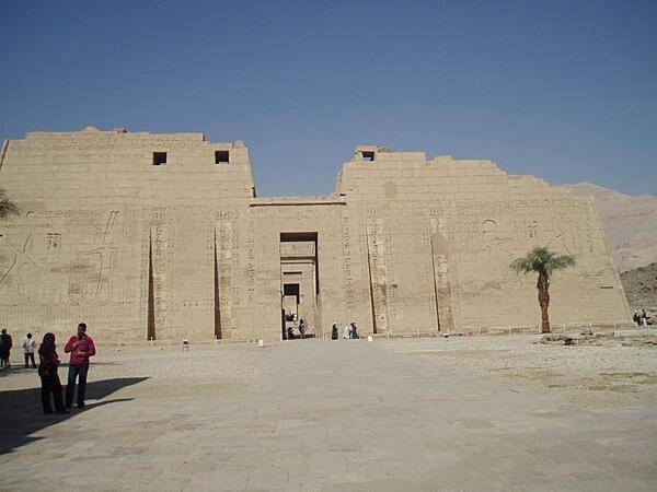
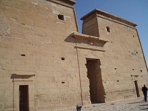
Pylons of the Mortuary Temple of Ramses III at Medinet Habu. The reliefs describe the pharaoh's military campaigns.
Pylons of the Mortuary Temple of Ramses III at Medinet Habu. The reliefs describe the pharaoh's military campaigns. • CIA World Factbook • 2020
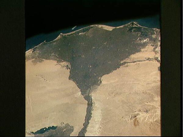
The Nile Delta of Egypt, irrigated by the Nile River and its many distributaries, is some of the richest farm land in the world and home to over half of Egypt's population. The capital city of Cairo lies at the apex of the delta in the middle of the scene. Across the river from Cairo one can see the three large pyramids and sphinx at Giza. The Suez Canal is just to the right of the delta; the Mediterranean Sea is at the top of the view. Click on photo for higher resolution. Image courtesy of NASA.
The Nile Delta of Egypt, irrigated by the Nile River and its many distributaries, is some of the richest farm land in the world and home to over half of Egypt's population. The capital city of Cairo lies at the apex of the delta in the middle of the scene. Across the river from Cairo one can see the three large pyramids and sphinx at Giza. The Suez Canal is just to the right of the delta; the Mediterranean Sea is at the top of the view. Click on photo for higher resolution. Image courtesy of NASA. • CIA World Factbook • 2020
Left pylon of the Mortuary Temple of Ramses III at Medinet Habu showing the pharaoh's military victories.
Left pylon of the Mortuary Temple of Ramses III at Medinet Habu showing the pharaoh's military victories. • CIA World Factbook • 2020
The Aswan High Dam (top of photo) is 4 km (2.5 mi) across and 111 m (364 ft) high. Completed in 1971, it was constructed to supply cheap hydroelectric power to both Egypt and Sudan by impounding, controlling, and regulating the flood waters of the Nile River in Lake Nasser, the world's second largest artificial lake. The lake extends over 800 km (500 mi) in length, covers an area of some 5,200 sq km (2,000 sq mi) and is as much as 107 m (350 ft) deep at the face of the dam. Click on photo for higher resolution. Image courtesy of NASA.
The Aswan High Dam (top of photo) is 4 km (2.5 mi) across and 111 m (364 ft) high. Completed in 1971, it was constructed to supply cheap hydroelectric power to both Egypt and Sudan by impounding, controlling, and regulating the flood waters of the Nile River in Lake Nasser, the world's second largest artificial lake. The lake extends over 800 km (500 mi) in length, covers an area of some 5,200 sq km (2,000 sq mi) and is as much as 107 m (350 ft) deep at the face of the dam. Click on photo for higher resolution. Image courtesy of NASA. • CIA World Factbook • 2020
The Nile Delta of Egypt, irrigated by the Nile River and its many distributaries, is some of the richest farm land in the world and home to over half of Egypt's population. The capital city of Cairo lies at the apex of the delta in the lower left. To the west of the river and near the delta apex one can see the three large pyramids and sphinx at Giza. The Suez Canal is just to the right of the delta; the rear of the space shuttle appears in the lower portion of the view. Click on photo for higher resolution. Image courtesy of NASA.
The Nile Delta of Egypt, irrigated by the Nile River and its many distributaries, is some of the richest farm land in the world and home to over half of Egypt's population. The capital city of Cairo lies at the apex of the delta in the lower left. To the west of the river and near the delta apex one can see the three large pyramids and sphinx at Giza. The Suez Canal is just to the right of the delta; the rear of the space shuttle appears in the lower portion of the view. Click on photo for higher resolution. Image courtesy of NASA. • CIA World Factbook • 2020
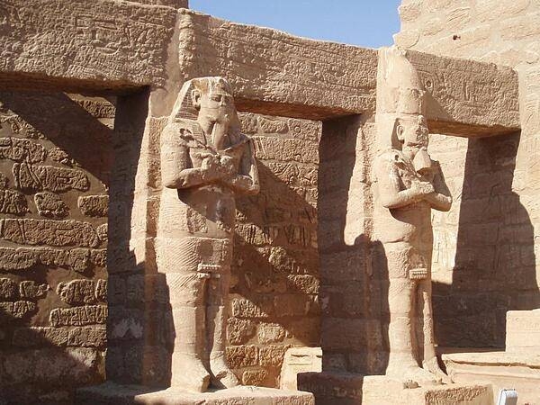
One of a pair of 30-meter (50-ft) statues of Amenhotep III that once stood before the pharaoh's mortuary temple in the Theban Necropolis on the west bank of the Nile opposite Luxor. The rest of the temple was dismantled, and the materials used for other construction projects. The statues were called the "Colossi of Memnom" by Egypt's late Ptolemaic (Greek) rulers who associated them with the myth of Memnon.
One of a pair of 30-meter (50-ft) statues of Amenhotep III that once stood before the pharaoh's mortuary temple in the Theban Necropolis on the west bank of the Nile opposite Luxor. The rest of the temple was dismantled, and the materials used for other construction projects. The statues were called the "Colossi of Memnom" by Egypt's late Ptolemaic (Greek) rulers who associated them with the myth of Memnon. • CIA World Factbook • 2020
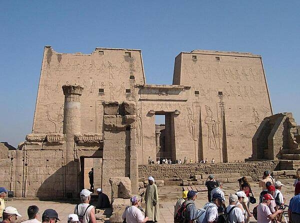
The first pylon of the Temple of Isis on the island of Philae in the Nile near Aswan.
The first pylon of the Temple of Isis on the island of Philae in the Nile near Aswan. • CIA World Factbook • 2020
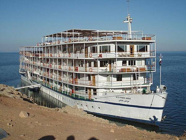
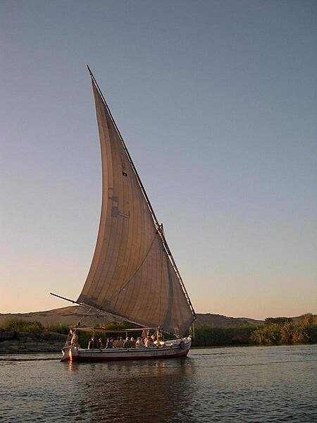
Typical cruise boat on the Nile River and on Lake Nasser.
Typical cruise boat on the Nile River and on Lake Nasser. • CIA World Factbook • 2020

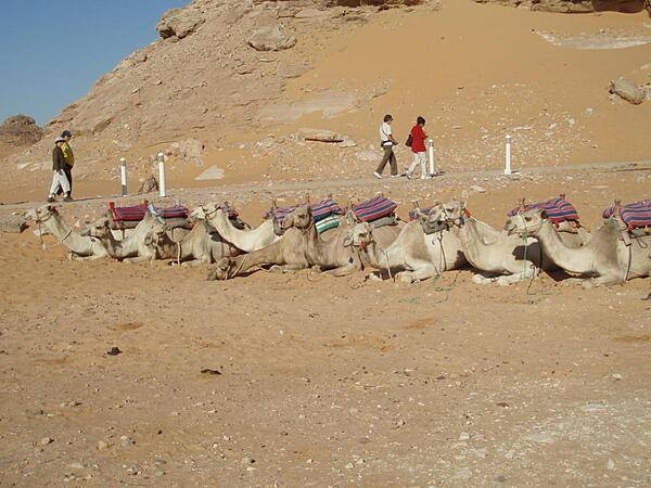
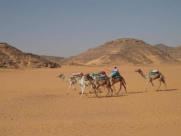
The immensity of the Sphinx becomes apparent when it is compared to a camel party riding along one of its paws.
The immensity of the Sphinx becomes apparent when it is compared to a camel party riding along one of its paws. • CIA World Factbook • 2020
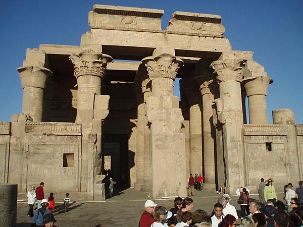
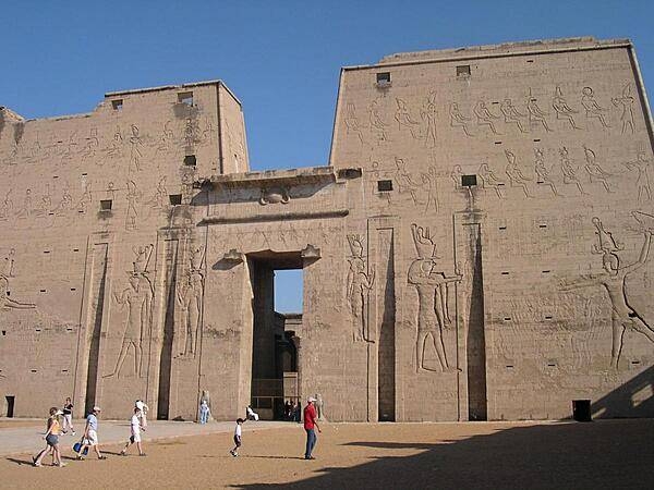
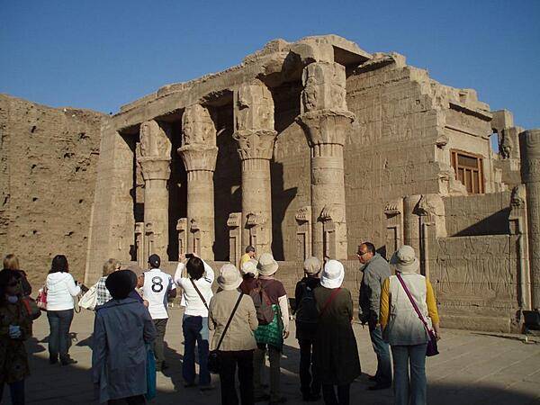
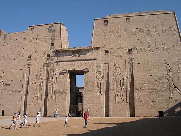
The temple complex of Edfu is one of the best preserved temple sites in Egypt, having been buried in sand for centuries. It is the second largest temple complex in Egypt.
The temple complex of Edfu is one of the best preserved temple sites in Egypt, having been buried in sand for centuries. It is the second largest temple complex in Egypt. • CIA World Factbook • 2020
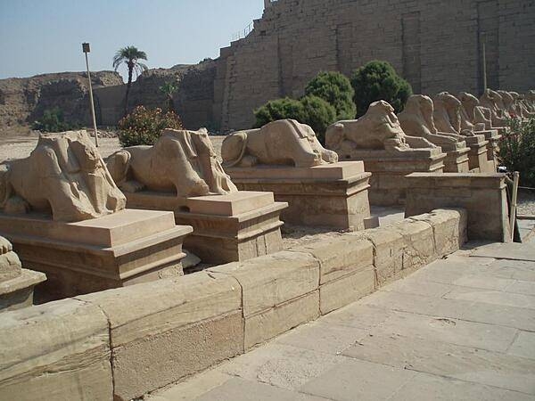
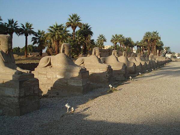
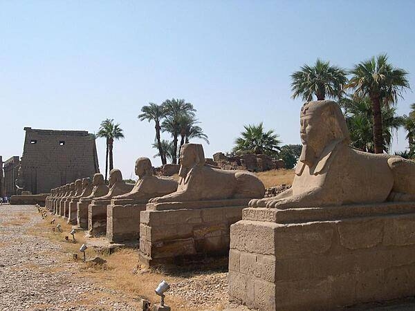
Avenue of ram-headed sphinxes leading into the Temple of Karnak complex at Luxor.
Avenue of ram-headed sphinxes leading into the Temple of Karnak complex at Luxor. • CIA World Factbook • 2020
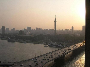
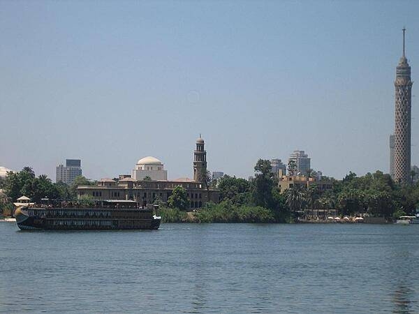
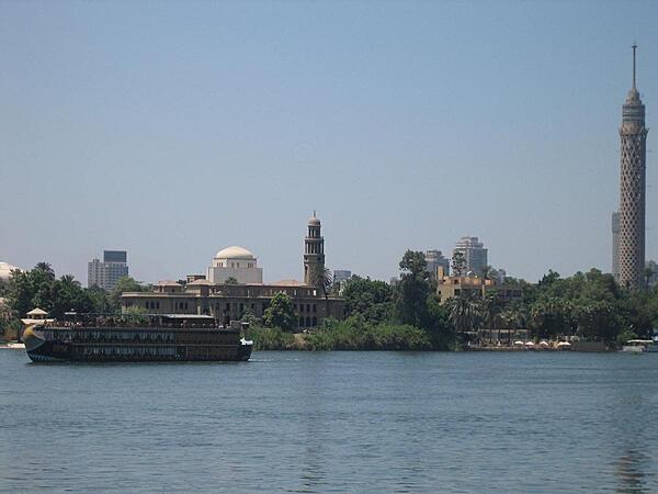
A view of Cairo from the Nile with the Cairo Tower, a free standing TV tower on Gezira Island, in the foreground.
A view of Cairo from the Nile with the Cairo Tower, a free standing TV tower on Gezira Island, in the foreground. • CIA World Factbook • 2020
Pyramid of Menkaure at Giza.
Pyramid of Menkaure at Giza. • CIA World Factbook • 2020
Avenue of the Sphinxes at the Temple of Luxor leading north to the Temple of Karnak. The avenue is being excavated.
Avenue of the Sphinxes at the Temple of Luxor leading north to the Temple of Karnak. The avenue is being excavated. • CIA World Factbook • 2020
CIA World Factbook • 2020
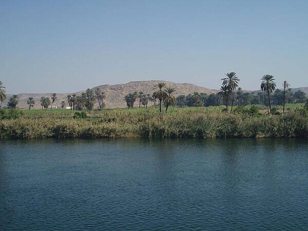
View along the Nile River south of Edfu.
View along the Nile River south of Edfu. • CIA World Factbook • 2020
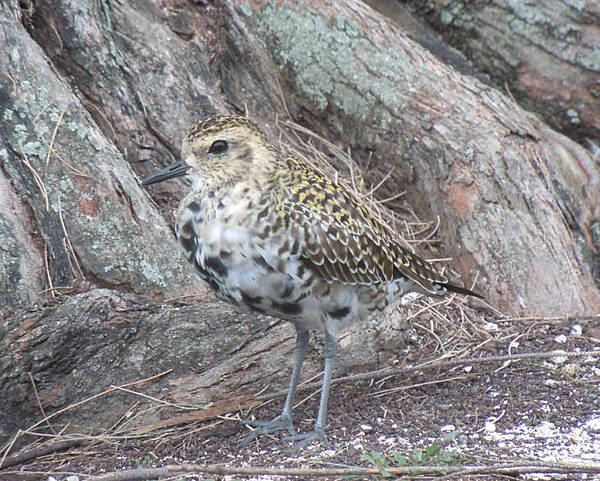
A juvenile Pacific golden-plover at Midway Atoll National Wildlife Refuge. Photo courtesy of USFWS/Noah Kahn.
A juvenile Pacific golden-plover at Midway Atoll National Wildlife Refuge. Photo courtesy of USFWS/Noah Kahn. • CIA World Factbook • 2020
Right pylon of the Temple of Horus at Edfu.
Right pylon of the Temple of Horus at Edfu. • CIA World Factbook • 2020
Hypostyle Hall at the Temple of Haroeris and Sobek at Kom Ombo. It was built between the 2nd century B.C. and the 1st century A.D. It is an unusual temple dedicated to two gods - to Haroeris as a manifestation of Horus represented as a falcon or a falcon-headed man and to Sobek depicted as a crocodile or as a crocodile-headed man. The temple has two of almost everything. The northern part is a temple of Haroeris. The southern part is a temple dedicated to Sobek.
Hypostyle Hall at the Temple of Haroeris and Sobek at Kom Ombo. It was built between the 2nd century B.C. and the 1st century A.D. It is an unusual temple dedicated to two gods - to Haroeris as a manifestation of Horus represented as a falcon or a falcon-headed man and to Sobek depicted as a crocodile or as a crocodile-headed man. The temple has two of almost everything. The northern part is a temple of Haroeris. The southern part is a temple dedicated to Sobek. • CIA World Factbook • 2020
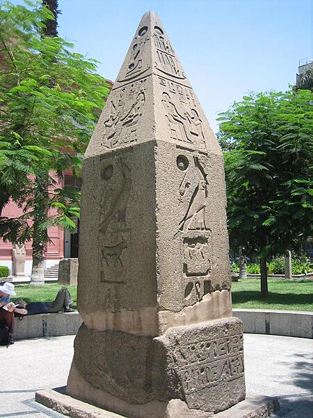
The upper portion of an obelisk on view on the grounds of the Egyptian Museum in Cairo.
The upper portion of an obelisk on view on the grounds of the Egyptian Museum in Cairo. • CIA World Factbook • 2020
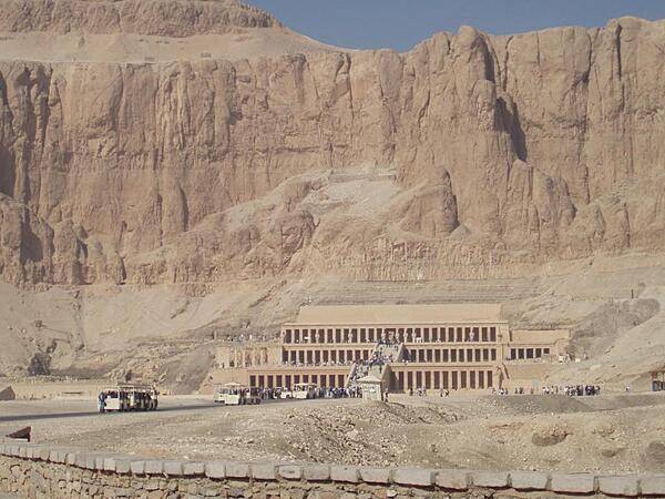
Mortuary Temple of Hatshepsut at Deir al-Bahri showing high cliffs in the background.
Mortuary Temple of Hatshepsut at Deir al-Bahri showing high cliffs in the background. • CIA World Factbook • 2020
Reliefs in the inner court of the Mortuary Temple of Ramses III at Medinet Habu still display some of their original colors - after more than 3,000 years!
Reliefs in the inner court of the Mortuary Temple of Ramses III at Medinet Habu still display some of their original colors - after more than 3,000 years! • CIA World Factbook • 2020
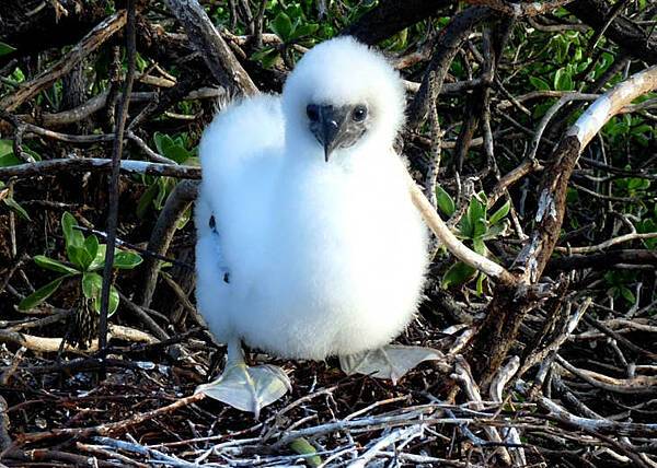
Juvenile red-footed booby on Johnston Atoll National Wildlife Refuge. Photo courtesy of the USFWS/Laura M. Beauregard.
Juvenile red-footed booby on Johnston Atoll National Wildlife Refuge. Photo courtesy of the USFWS/Laura M. Beauregard. • CIA World Factbook • 2020
CIA World Factbook • 2020
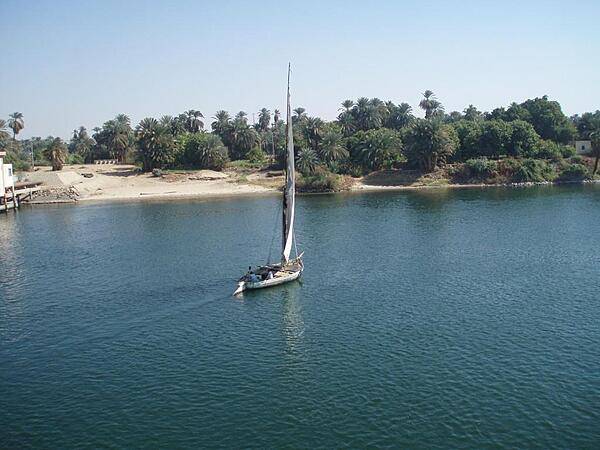
A felucca glides along the Nile River south of Edfu.
A felucca glides along the Nile River south of Edfu. • CIA World Factbook • 2020
The remains of an obelisk not erected because of cracking. The obelisks of Hatshepsut and Thutmose I appear in the background at the Temple of Karnak in Luxor.
The remains of an obelisk not erected because of cracking. The obelisks of Hatshepsut and Thutmose I appear in the background at the Temple of Karnak in Luxor. • CIA World Factbook • 2020
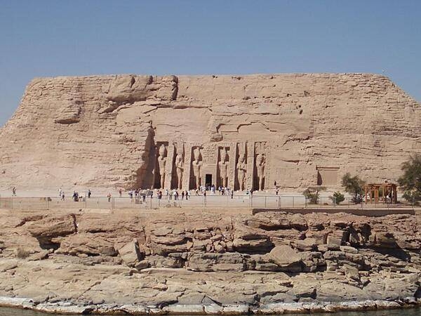
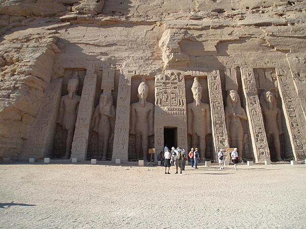
The Temple of Queen Nefertari at Abu Simbel. The temple was dedicated to the god, Hathor. The temple stands 100 m (328 ft) to the right of the Temple of Ramses II. It is fronted by six colossal 10-meter (33-foot) statues of Ramses II and Nefertari. It was unusual that the two statues of the queen were the same height as the four statues of the king. It also was unusual that a temple was dedicated to a queen.
The Temple of Queen Nefertari at Abu Simbel. The temple was dedicated to the god, Hathor. The temple stands 100 m (328 ft) to the right of the Temple of Ramses II. It is fronted by six colossal 10-meter (33-foot) statues of Ramses II and Nefertari. It was unusual that the two statues of the queen were the same height as the four statues of the king. It also was unusual that a temple was dedicated to a queen. • CIA World Factbook • 2020
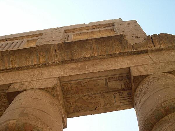
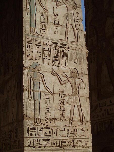
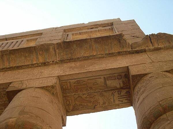
The lintels of the Great Hypostyle Hall at Karnak also display hieroglyphs.
The lintels of the Great Hypostyle Hall at Karnak also display hieroglyphs. • CIA World Factbook • 2020
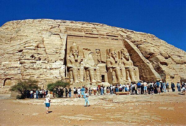
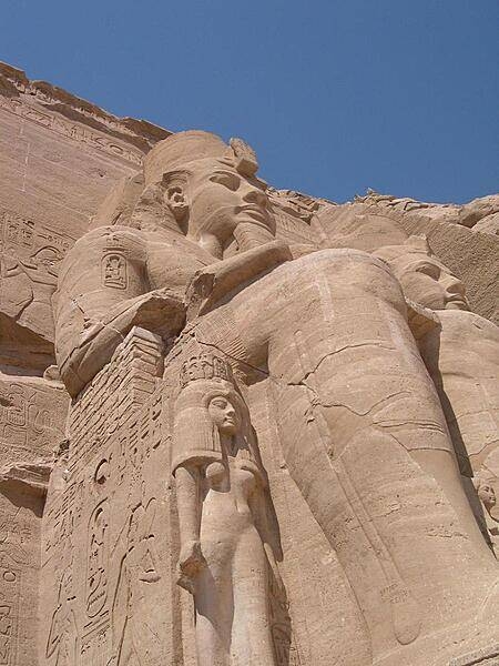
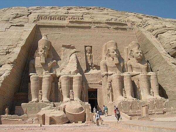
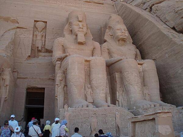
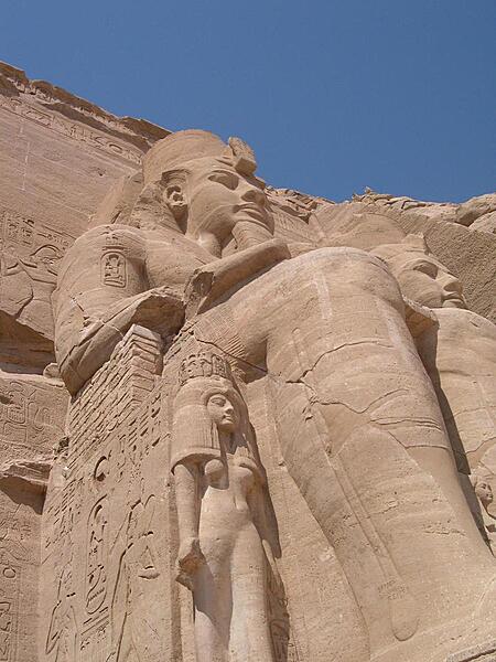
The temples at Abu Simbel were moved to higher ground in the 1960s to save them from the flooding caused by the completion of the Aswan Dam. The carvings on the Great Temple shown here (completed about 1265 B.C.) dwarf mere humans.
The temples at Abu Simbel were moved to higher ground in the 1960s to save them from the flooding caused by the completion of the Aswan Dam. The carvings on the Great Temple shown here (completed about 1265 B.C.) dwarf mere humans. • CIA World Factbook • 2020
Left pylon of the Temple or Ramses II at Abu Simbel. It was decided not to place the fallen head in its original position during the reconstruction.
Left pylon of the Temple or Ramses II at Abu Simbel. It was decided not to place the fallen head in its original position during the reconstruction. • CIA World Factbook • 2020
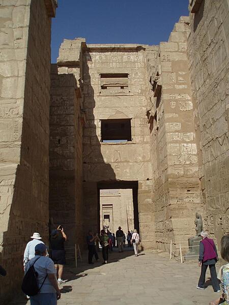
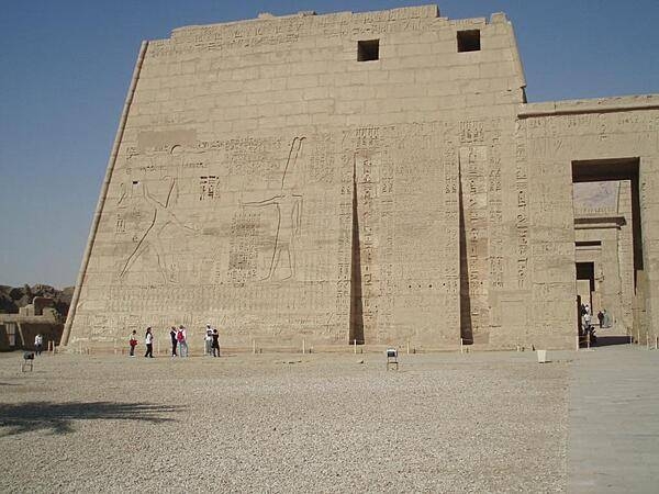
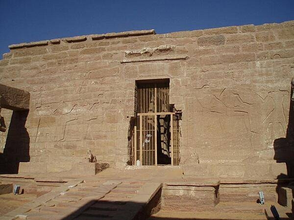
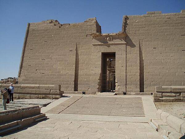
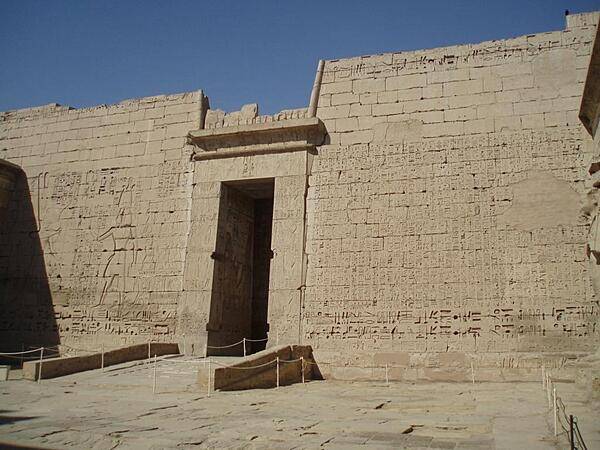
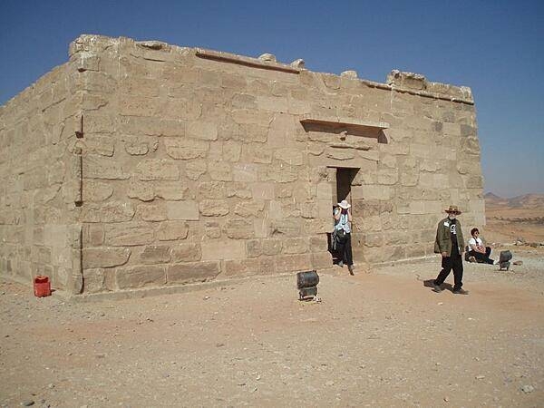
The Syrian Gates - entrance to the Mortuary Temple of Ramses III at Medinet Habu.
The Syrian Gates - entrance to the Mortuary Temple of Ramses III at Medinet Habu. • CIA World Factbook • 2020
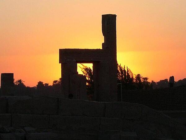
The awesome ruins of Karnak Temple in Luxor.
The awesome ruins of Karnak Temple in Luxor. • CIA World Factbook • 2020
CIA World Factbook • 2020
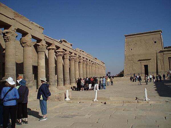
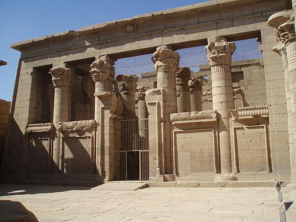
The West Colonnade in the Temple of Isis on the island of Philae in the Nile near Aswan. It was built during the Roman period.
The West Colonnade in the Temple of Isis on the island of Philae in the Nile near Aswan. It was built during the Roman period. • CIA World Factbook • 2020
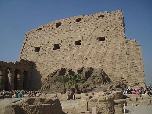
Rear of the First Pylon in the Temple of Karnak showing the remains of the mud-brick rampart used to construct the pylon.
Rear of the First Pylon in the Temple of Karnak showing the remains of the mud-brick rampart used to construct the pylon. • CIA World Factbook • 2020
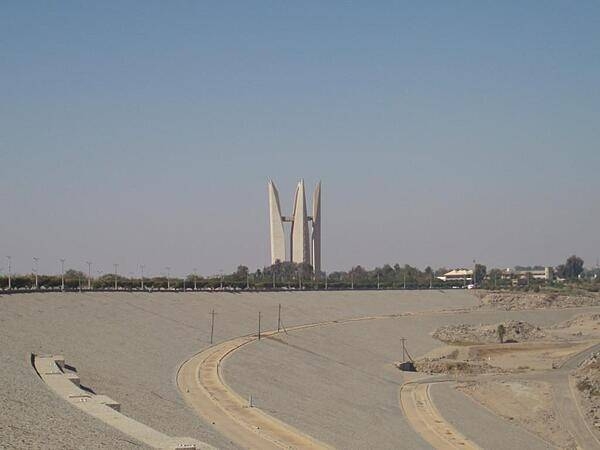
The Soviet-Egyptian stylized lotus monument commemorating the construction of the dam.
The Soviet-Egyptian stylized lotus monument commemorating the construction of the dam. • CIA World Factbook • 2020
One of eight sphinxes leading to the Temple of Amun (Ra-Harakhte) and Amun Ra at Wadi el Seboua.
One of eight sphinxes leading to the Temple of Amun (Ra-Harakhte) and Amun Ra at Wadi el Seboua. • CIA World Factbook • 2020
Reliefs on the walls at the Temple of Luxor.
Reliefs on the walls at the Temple of Luxor. • CIA World Factbook • 2020
Pylons of Temple of Amun and Amun Ra at Wadi el Seboua (Arabic for Valley of the Lions). The temple was constructed in honor of Ramses II by Setau, the Nubian viceroy of Kush (Nubia).
Pylons of Temple of Amun and Amun Ra at Wadi el Seboua (Arabic for Valley of the Lions). The temple was constructed in honor of Ramses II by Setau, the Nubian viceroy of Kush (Nubia). • CIA World Factbook • 2020
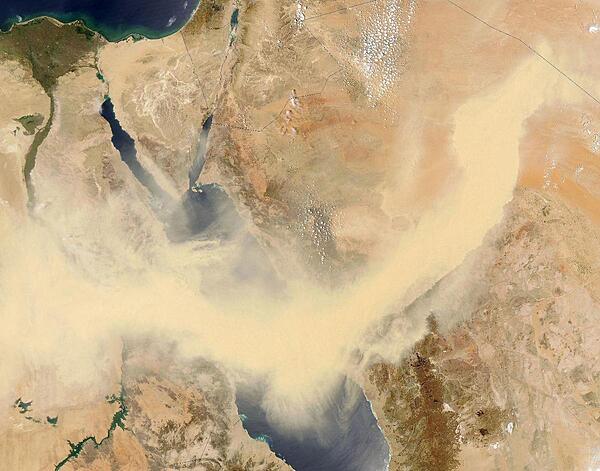
A thick snake of tan dust slithers across Saudi Arabia, the Red Sea, and Egypt in this dramatic true-color image from 13 May 2005. The dust is so thick that it is completely opaque for well over 1,100 km (700 mi) across its south-moving front, from the border of Iraq, across the Arabian Desert of Saudi Arabia, and eastern Egypt and the green ribbon of the Nile. Click on photo for higher resolution. Image courtesy of NASA.
A thick snake of tan dust slithers across Saudi Arabia, the Red Sea, and Egypt in this dramatic true-color image from 13 May 2005. The dust is so thick that it is completely opaque for well over 1,100 km (700 mi) across its south-moving front, from the border of Iraq, across the Arabian Desert of Saudi Arabia, and eastern Egypt and the green ribbon of the Nile. Click on photo for higher resolution. Image courtesy of NASA. • CIA World Factbook • 2020
CIA World Factbook • 2020
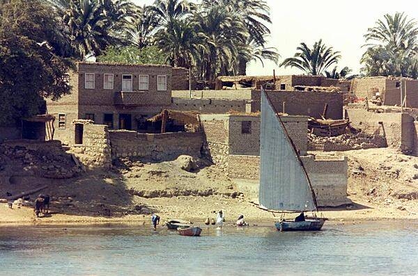
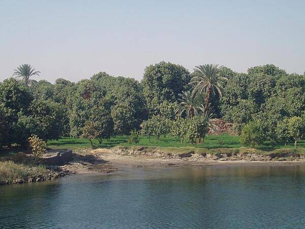
Houses along the Nile. Feluccas remain the most common form of transportation along the river.
Houses along the Nile. Feluccas remain the most common form of transportation along the river. • CIA World Factbook • 2020
CIA World Factbook • 2020
Inner wall at the Temple of Amun and Amun Ra at Wadi el Seboua.
Inner wall at the Temple of Amun and Amun Ra at Wadi el Seboua. • CIA World Factbook • 2020
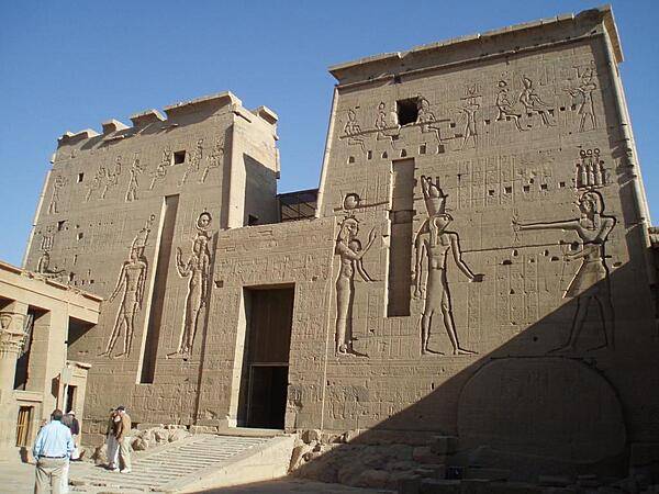
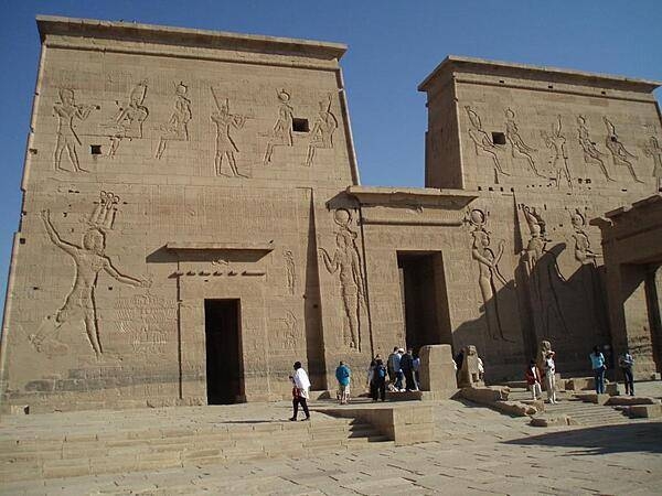
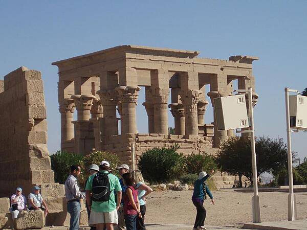
The second pylon of the Temple of Isis on the island of Philae in the Nile near Aswan. This is the entrance to the temple. The original Philae Island was flooded by the waters of Lake Nasser behind the Aswan High Dam. The island of Agilqiyya was reconfigured to have similar topography to the old island of Philae and is sometime referred to as the New Philae Island. The Temple of Isis was moved to the island to escape the rising waters of the lake.
The second pylon of the Temple of Isis on the island of Philae in the Nile near Aswan. This is the entrance to the temple. The original Philae Island was flooded by the waters of Lake Nasser behind the Aswan High Dam. The island of Agilqiyya was reconfigured to have similar topography to the old island of Philae and is sometime referred to as the New Philae Island. The Temple of Isis was moved to the island to escape the rising waters of the lake. • CIA World Factbook • 2020
Left pylon of the Temple of Horus at Edfu.
Left pylon of the Temple of Horus at Edfu. • CIA World Factbook • 2020
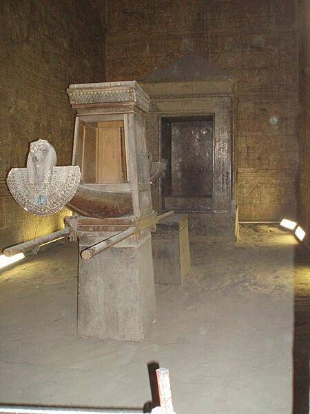
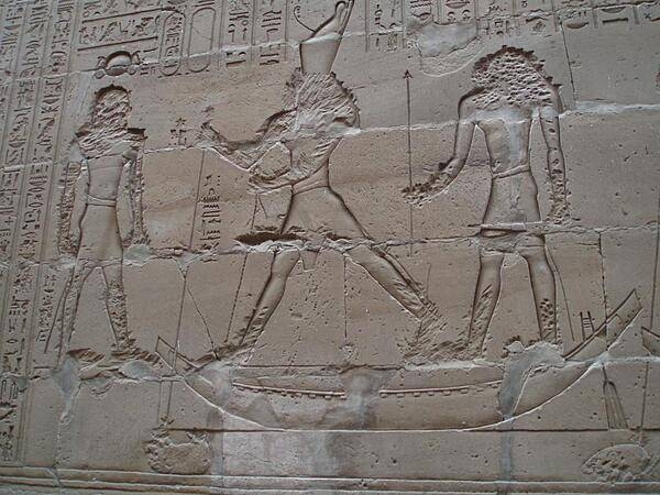
The reproduction of a barque used to transport the god Horus in religious processions around the town of Edfu and on boats north to Dendera to visit the god Hathor. The barque is in the inner sanctuary of the Temple of Horus at Edfu.
The reproduction of a barque used to transport the god Horus in religious processions around the town of Edfu and on boats north to Dendera to visit the god Hathor. The barque is in the inner sanctuary of the Temple of Horus at Edfu. • CIA World Factbook • 2020
CIA World Factbook • 2020
CIA World Factbook • 2020
View along the Nile River south of Edfu.
View along the Nile River south of Edfu. • CIA World Factbook • 2020
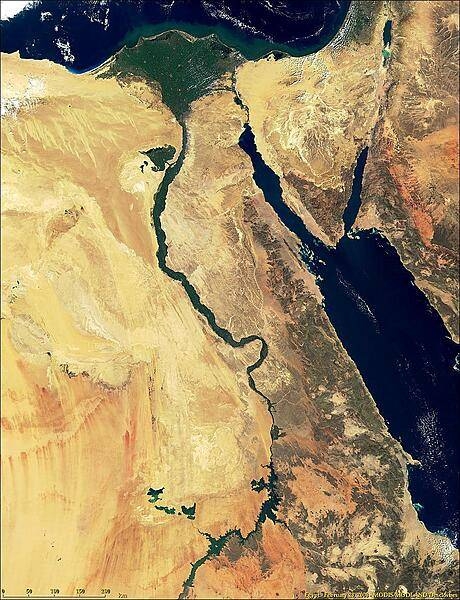
A remarkably detailed satellite image of Egypt vividly displays the winding Nile River and its distinctive delta. The Sinai peninsula and Red Sea are on the right. Photo courtesy of NASA.
A remarkably detailed satellite image of Egypt vividly displays the winding Nile River and its distinctive delta. The Sinai peninsula and Red Sea are on the right. Photo courtesy of NASA. • CIA World Factbook • 2020
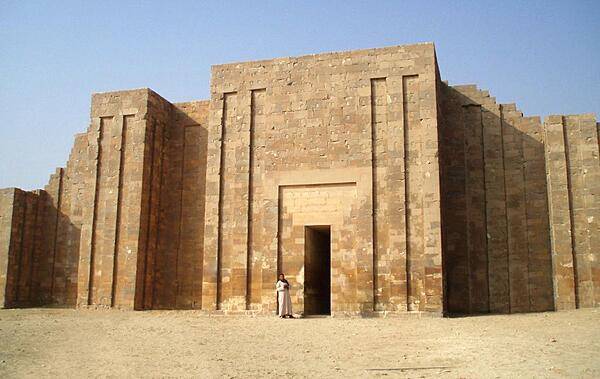
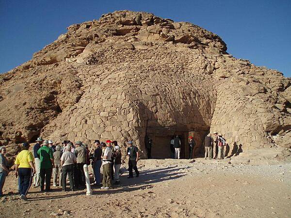
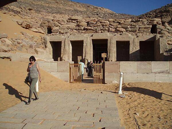
Entrance to funerary complex of Pharaoh Djoser at Saqqara.
Entrance to funerary complex of Pharaoh Djoser at Saqqara. • CIA World Factbook • 2020
Hypostyle Hall at the Temple of Horus at Edfu.
Hypostyle Hall at the Temple of Horus at Edfu. • CIA World Factbook • 2020

CIA World Factbook • 2020
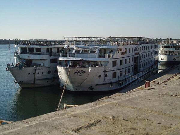
Typical cruise boats on the Nile River and on Lake Nasser. On the river, the traffic is so heavy that passengers disembark by walking through other boats. There are relatively few boats on Lake Nasser.
Typical cruise boats on the Nile River and on Lake Nasser. On the river, the traffic is so heavy that passengers disembark by walking through other boats. There are relatively few boats on Lake Nasser. • CIA World Factbook • 2020
Remains of storerooms and housing at the Temple of Hathor at Dendera. Temples were constructed of stone. Living quarters, including palaces, were built of mud brick.
Remains of storerooms and housing at the Temple of Hathor at Dendera. Temples were constructed of stone. Living quarters, including palaces, were built of mud brick. • CIA World Factbook • 2020
Pylons of the Temple of Isis and the Nubian solar and fertility deity, Madulis, at Kalabshah. It is the largest free-standing Nubian temple. Construction began in A.D. 23 during the reign of the Roman Emperor Octavius Augustus. The temple was moved 48 km (30 mi) north when the High Dam was built.
Pylons of the Temple of Isis and the Nubian solar and fertility deity, Madulis, at Kalabshah. It is the largest free-standing Nubian temple. Construction began in A.D. 23 during the reign of the Roman Emperor Octavius Augustus. The temple was moved 48 km (30 mi) north when the High Dam was built. • CIA World Factbook • 2020
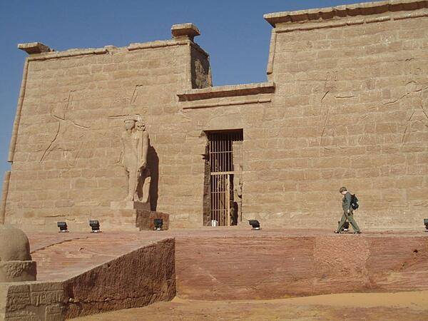
The Temple of Amada is the oldest surviving temple in the Nubian region. It was originally built by Thutmosis III (1479 B.C. to 1425 B.C.) and later remodeled by his son Amenhotep II.
The Temple of Amada is the oldest surviving temple in the Nubian region. It was originally built by Thutmosis III (1479 B.C. to 1425 B.C.) and later remodeled by his son Amenhotep II. • CIA World Factbook • 2020
CIA World Factbook • 2020
CIA World Factbook • 2020
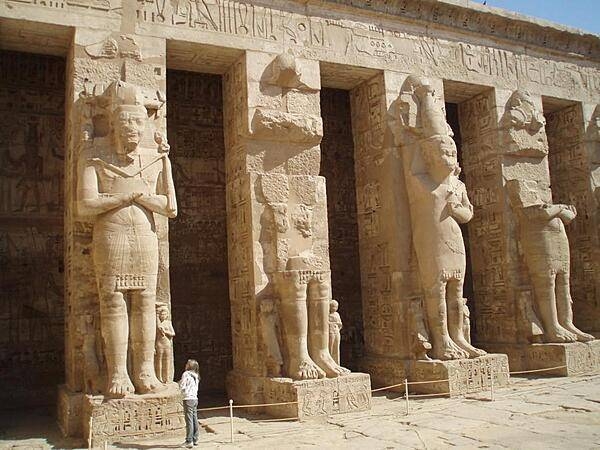
Statues in the hypostyle hall of the Mortuary Temple of Ramses III at Medinet Habu.
Statues in the hypostyle hall of the Mortuary Temple of Ramses III at Medinet Habu. • CIA World Factbook • 2020
One of eight sphinxes leading to the Temple of Amun and Amun Ra at Wadi el Seboua.
One of eight sphinxes leading to the Temple of Amun and Amun Ra at Wadi el Seboua. • CIA World Factbook • 2020
Reliefs showing the god Horus defeating his uncle Seth at the Temple of Horus at Edfu. The reliefs probably were damaged by early Christians to remove faces and hands.
Reliefs showing the god Horus defeating his uncle Seth at the Temple of Horus at Edfu. The reliefs probably were damaged by early Christians to remove faces and hands. • CIA World Factbook • 2020
CIA World Factbook • 2020
Walls of the inner court of the Mortuary Temple of Ramses III at Medinet Habu.
Walls of the inner court of the Mortuary Temple of Ramses III at Medinet Habu. • CIA World Factbook • 2020
Pylon of the Temple of Dakka at Wadi el Seboua dedicated to the ibis-headed Thoth, the god of wisdom. Moved to this location in the 1960s because of the rising waters of Lake Nasser.
Pylon of the Temple of Dakka at Wadi el Seboua dedicated to the ibis-headed Thoth, the god of wisdom. Moved to this location in the 1960s because of the rising waters of Lake Nasser. • CIA World Factbook • 2020
Camels at the Temple of Amada.
Camels at the Temple of Amada. • CIA World Factbook • 2020
CIA World Factbook • 2020
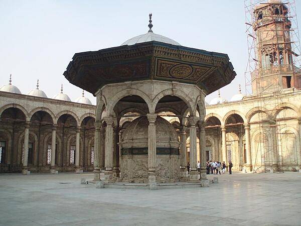
Octagonal ablution fountain in the courtyard of the Muhammad Ali Mosque in Cairo.
Octagonal ablution fountain in the courtyard of the Muhammad Ali Mosque in Cairo. • CIA World Factbook • 2020

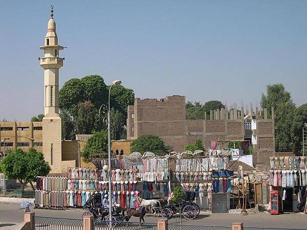
A streetside clothes market in Luxor with a minaret in the background.
A streetside clothes market in Luxor with a minaret in the background. • CIA World Factbook • 2020
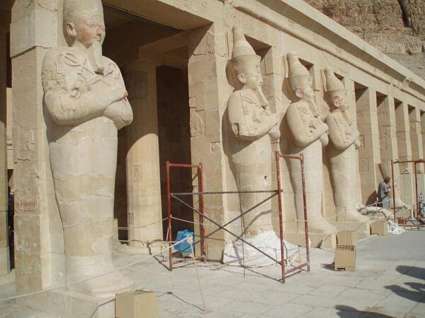
Statues of Hatshepsut as the god Osiris before the Mortuary Temple of Hatshepsut at Deir al-Bahri.
Statues of Hatshepsut as the god Osiris before the Mortuary Temple of Hatshepsut at Deir al-Bahri. • CIA World Factbook • 2020
Reliefs showing the god Horus defeating his uncle Seth at the Temple of Horus at Edfu. The reliefs probably were damaged by early Christians to remove faces and hands.
Reliefs showing the god Horus defeating his uncle Seth at the Temple of Horus at Edfu. The reliefs probably were damaged by early Christians to remove faces and hands. • CIA World Factbook • 2020
CIA World Factbook • 2020
Intense sunglint turns the waters of Lake Nasser to silver. Image courtesy of NASA.
Intense sunglint turns the waters of Lake Nasser to silver. Image courtesy of NASA. • CIA World Factbook • 2020
Tomb of the Penut, the viceroy of Kush (Nubia) dug into a hill. Moved to this location in the 1960s because of the rising waters of Lake Nasser.
Tomb of the Penut, the viceroy of Kush (Nubia) dug into a hill. Moved to this location in the 1960s because of the rising waters of Lake Nasser. • CIA World Factbook • 2020
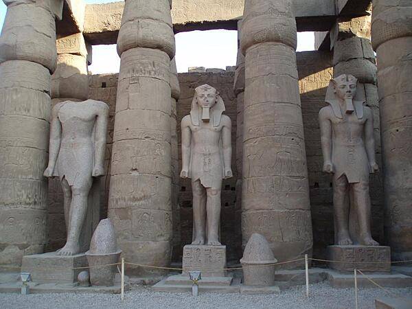
Hypostyle Hall at the Temple of Karnak in Luxor.
Hypostyle Hall at the Temple of Karnak in Luxor. • CIA World Factbook • 2020
CIA World Factbook • 2020
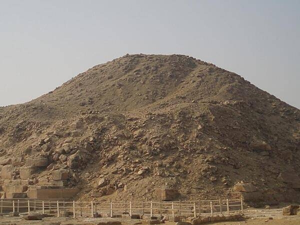
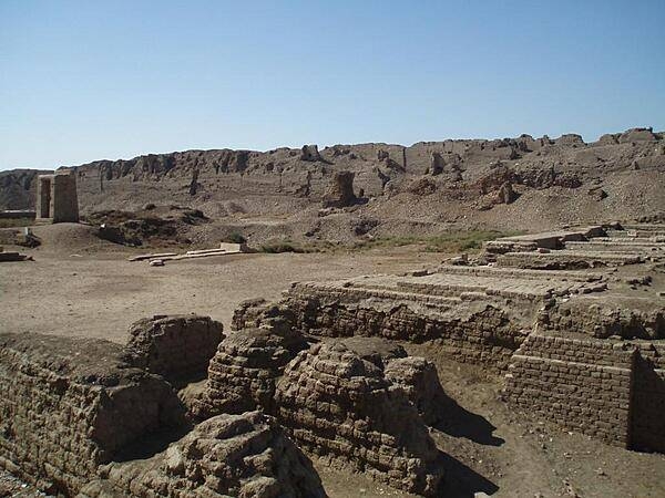
Ruins of the Pyramid of Unis at Saqqara. Much of the stone outer covering was taken to be used in other constructions.
Ruins of the Pyramid of Unis at Saqqara. Much of the stone outer covering was taken to be used in other constructions. • CIA World Factbook • 2020
Views along the Nile River at sunset south of Luxor.
Views along the Nile River at sunset south of Luxor. • CIA World Factbook • 2020
CIA World Factbook • 2020

CIA World Factbook • 2020
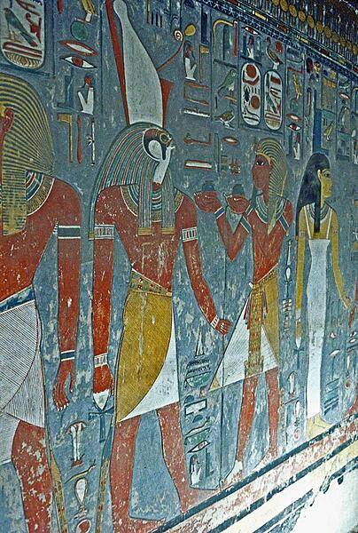
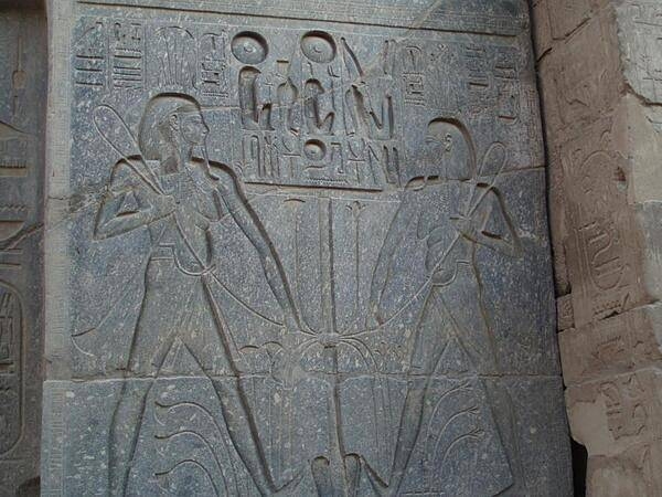
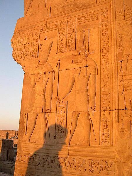
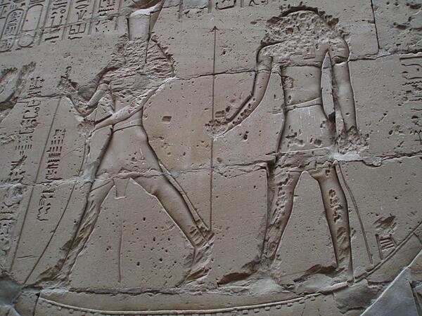
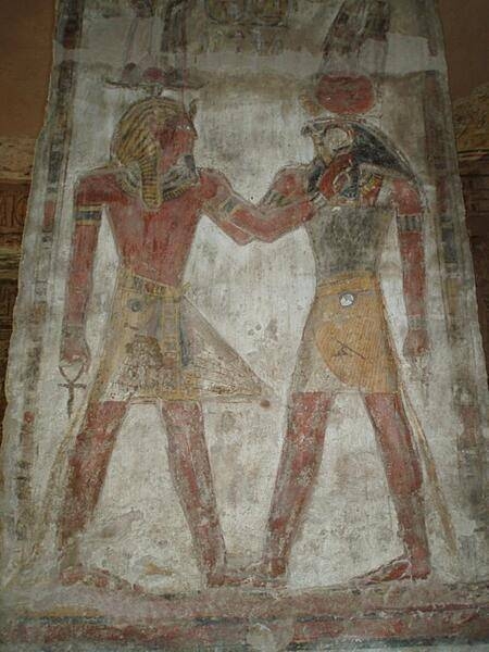
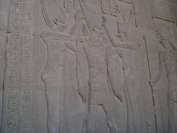
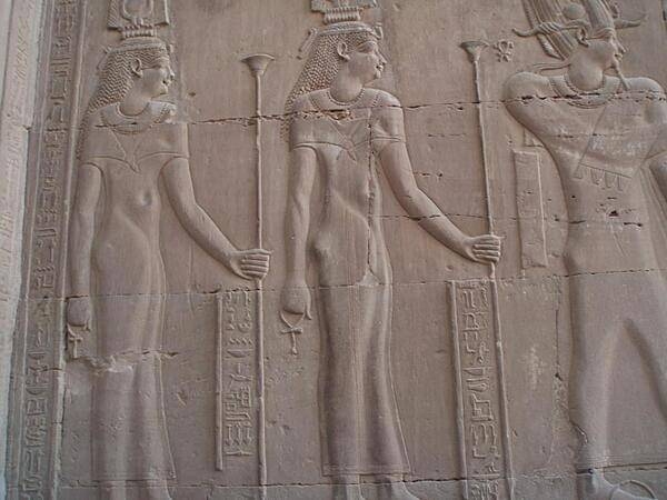
Presenting gifts to the god Horus wearing the double crown (white crown of Upper Egypt, red crown of Lower Egypt). The paint on this tomb wall remains vivid.
Presenting gifts to the god Horus wearing the double crown (white crown of Upper Egypt, red crown of Lower Egypt). The paint on this tomb wall remains vivid. • CIA World Factbook • 2020
Statues of Ramses II at the Temple of Luxor.
Statues of Ramses II at the Temple of Luxor. • CIA World Factbook • 2020
CIA World Factbook • 2020
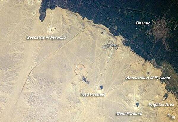
The pyramids at Dashur, about 40 km (25 mi) south of Cairo. The gray-brown built-up area of the village of Dashur in the upper right is surrounded by the green agricultural land of the Nile Delta, which forms a distinct boundary with the tan desert to the west. It is in the desert that the monuments of the ancient rulers of Egypt are found. Click on photo for higher resolution. Image courtesy of NASA.
The pyramids at Dashur, about 40 km (25 mi) south of Cairo. The gray-brown built-up area of the village of Dashur in the upper right is surrounded by the green agricultural land of the Nile Delta, which forms a distinct boundary with the tan desert to the west. It is in the desert that the monuments of the ancient rulers of Egypt are found. Click on photo for higher resolution. Image courtesy of NASA. • CIA World Factbook • 2020
Portal of the Temple of Hathor at Dendera. The temple was built between the 4th and 1st centuries B.C.
Portal of the Temple of Hathor at Dendera. The temple was built between the 4th and 1st centuries B.C. • CIA World Factbook • 2020
Relief at the Temple of el Derr showing Ramses II and the god, Ra-Harakhte (Ra and Horus).
Relief at the Temple of el Derr showing Ramses II and the god, Ra-Harakhte (Ra and Horus). • CIA World Factbook • 2020

CIA World Factbook • 2020
CIA World Factbook • 2020
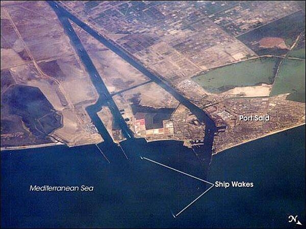
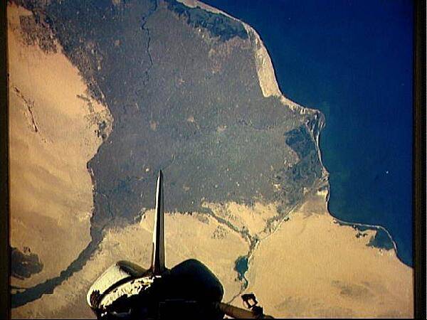
This oblique image captures a northbound convoy of cargo ships entering the Mediterranean Sea from the Suez Canal (leftmost canal branch at image center). The Canal connects Port Said on the Mediterranean Sea with the port of Suez on the Red Sea, and provides an essentially direct route for transport of goods between Europe and Asia. The Canal is 163 km (101 mi) long and 300 m (984 ft) wide at its narrowest point - sufficiently wide for ships as large as aircraft carriers to traverse it. Transit time from end to end averages 14 hours. Image courtesy of NASA.
This oblique image captures a northbound convoy of cargo ships entering the Mediterranean Sea from the Suez Canal (leftmost canal branch at image center). The Canal connects Port Said on the Mediterranean Sea with the port of Suez on the Red Sea, and provides an essentially direct route for transport of goods between Europe and Asia. The Canal is 163 km (101 mi) long and 300 m (984 ft) wide at its narrowest point - sufficiently wide for ships as large as aircraft carriers to traverse it. Transit time from end to end averages 14 hours. Image courtesy of NASA. • CIA World Factbook • 2020
Birthing house or mammisi at the Temple of Horus at Edfu.
Birthing house or mammisi at the Temple of Horus at Edfu. • CIA World Factbook • 2020
The birthing house of mammisi at the Temple of Isis on the island of Philae in the Nile near Aswan.
The birthing house of mammisi at the Temple of Isis on the island of Philae in the Nile near Aswan. • CIA World Factbook • 2020
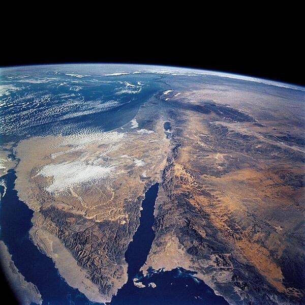
A panoramic view of the entire Sinai Peninsula and the nearby Nile River Delta and eastern Mediterranean coastal region. The Suez Canal, at the top of the scene just to the right of the Delta, connects the Mediterranean Sea with the Gulf of Suez. The water body to the right of the peninsula is the Gulf of Aqaba. Click on photo for higher resolution. Image courtesy of NASA.
A panoramic view of the entire Sinai Peninsula and the nearby Nile River Delta and eastern Mediterranean coastal region. The Suez Canal, at the top of the scene just to the right of the Delta, connects the Mediterranean Sea with the Gulf of Suez. The water body to the right of the peninsula is the Gulf of Aqaba. Click on photo for higher resolution. Image courtesy of NASA. • CIA World Factbook • 2020
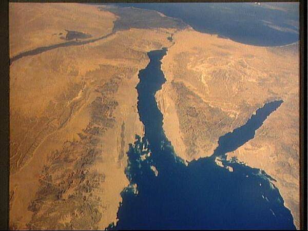
A view of the Sinai Peninsula and the Dead Sea rift area. The left side of the view is dominated by the great triangle of the Sinai peninsula, which is partly obscured by clouds. The Gulf of Aqaba is the finger of the Red Sea (bottom center) pointing north to the Dead Sea, the small body of water near the center of the view. The gulf and the Dead Sea are northerly extensions of the same geological rift that resulted in the opening of the Red Sea. The Gulf of Suez appears in the lower left corner. Click on photo for higher resolution. Image courtesy of NASA.
A view of the Sinai Peninsula and the Dead Sea rift area. The left side of the view is dominated by the great triangle of the Sinai peninsula, which is partly obscured by clouds. The Gulf of Aqaba is the finger of the Red Sea (bottom center) pointing north to the Dead Sea, the small body of water near the center of the view. The gulf and the Dead Sea are northerly extensions of the same geological rift that resulted in the opening of the Red Sea. The Gulf of Suez appears in the lower left corner. Click on photo for higher resolution. Image courtesy of NASA. • CIA World Factbook • 2020
Relief at the Temple of Haroeris and Sobek at Kom Ombo showing Haroeris being crowned by gods.
Relief at the Temple of Haroeris and Sobek at Kom Ombo showing Haroeris being crowned by gods. • CIA World Factbook • 2020
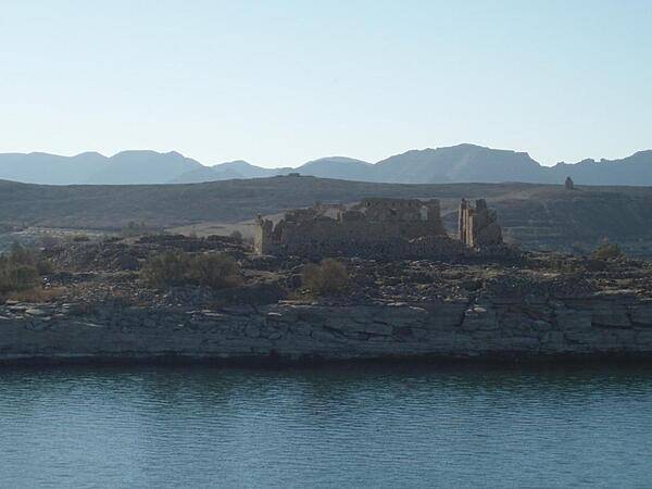
Ruins of a Byzantine church at Kasr Ibrim in Lake Nasser. Kasr Ibrim originally was a major city perched on a cliff above the Nile River but the flooding of Lake Nasser transformed it into an island. Kasr Ibrim was the site of military fortifications from the times of the pharaohs.
Ruins of a Byzantine church at Kasr Ibrim in Lake Nasser. Kasr Ibrim originally was a major city perched on a cliff above the Nile River but the flooding of Lake Nasser transformed it into an island. Kasr Ibrim was the site of military fortifications from the times of the pharaohs. • CIA World Factbook • 2020
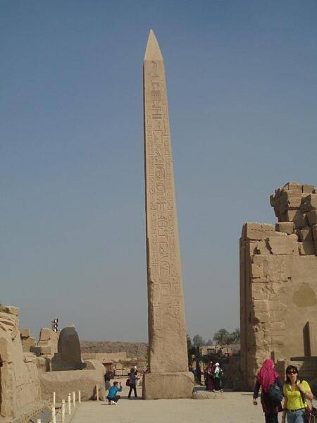
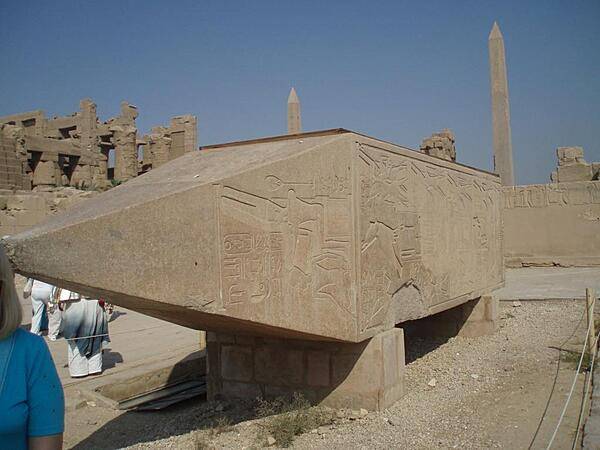
Obelisk of Hatshepsut at the Temple of Karnak in Luxor.
Obelisk of Hatshepsut at the Temple of Karnak in Luxor. • CIA World Factbook • 2020
Statues of Ramses II in the Temple of Amun and Amun Ra at Wadi el Seboua.
Statues of Ramses II in the Temple of Amun and Amun Ra at Wadi el Seboua. • CIA World Factbook • 2020
Hypostyle hall at the Temple of Isis and the Nubian solar and fertility deity, Madulis, at Kalabshah.
Hypostyle hall at the Temple of Isis and the Nubian solar and fertility deity, Madulis, at Kalabshah. • CIA World Factbook • 2020

CIA World Factbook • 2020
CIA World Factbook • 2020

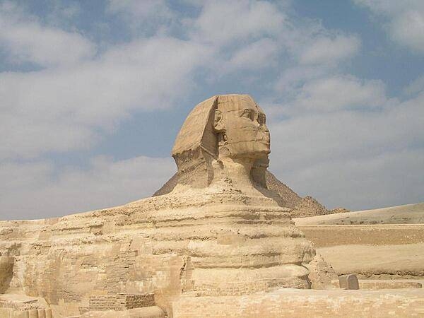
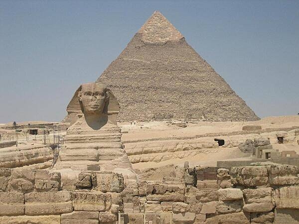
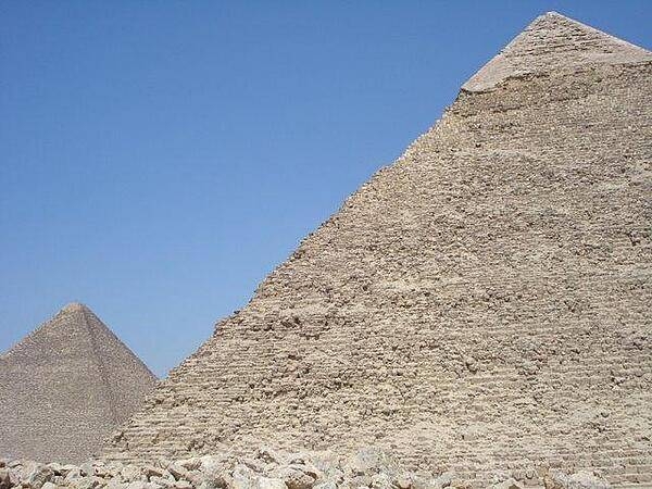
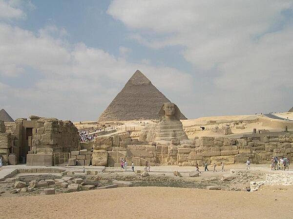
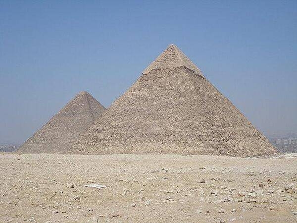
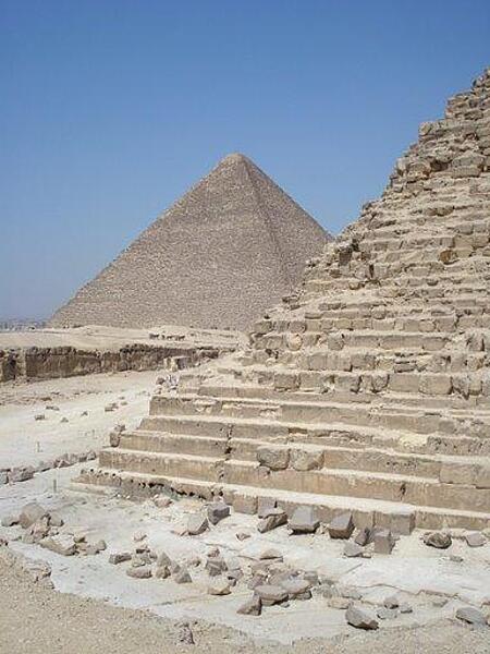
The Sphinx and the Pyramid of Khafre at Giza. Unlike the pyramids, the Sphinx was not assembled piece by piece, but was carved from a single mass of limestone.
The Sphinx and the Pyramid of Khafre at Giza. Unlike the pyramids, the Sphinx was not assembled piece by piece, but was carved from a single mass of limestone. • CIA World Factbook • 2020
Camels at the Temple of Amun and Amun Ra at Wadi el Seboua.
Camels at the Temple of Amun and Amun Ra at Wadi el Seboua. • CIA World Factbook • 2020
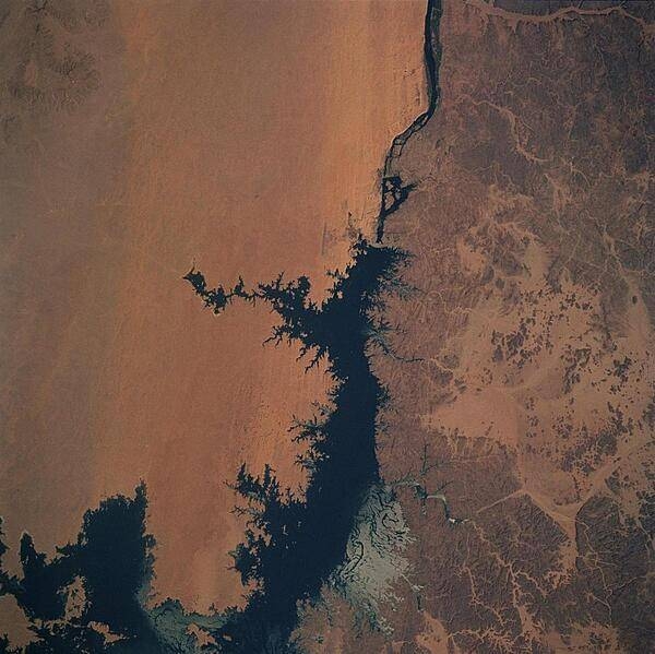
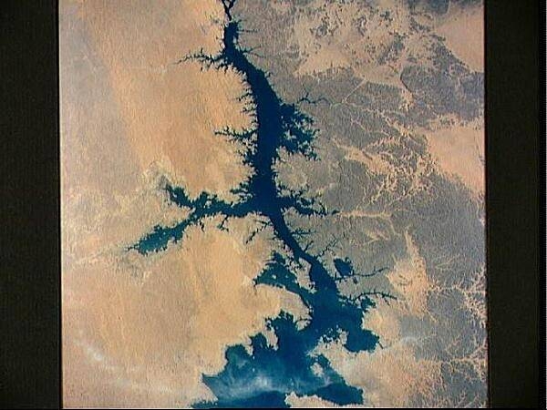
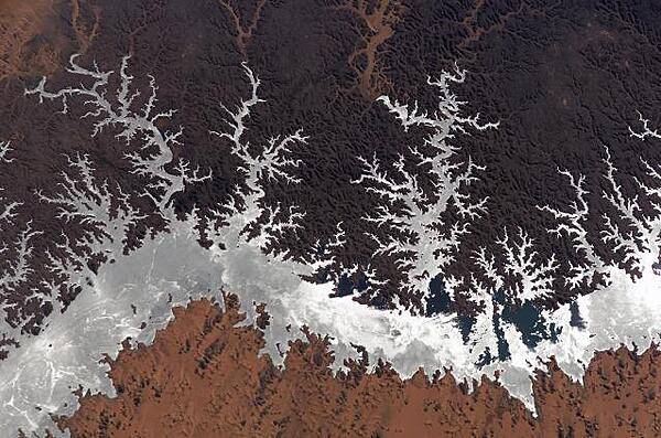
Aswan Dam (upper center of image) and Lake Nasser along the Nile River. The dam controls the flow of the Nile River forming Lake Nasser. The light-colored areas in the lake are where the sun is reflecting off the surface of the water. These areas are fairly calm and not disturbed by wind gusts, enabling the sun glint to show water current patterns on the surface. The Aswan runway is seen as a dark set of lines just west of the Aswan Dam. Click on photo for higher resolution. Image courtesy of NASA.
Aswan Dam (upper center of image) and Lake Nasser along the Nile River. The dam controls the flow of the Nile River forming Lake Nasser. The light-colored areas in the lake are where the sun is reflecting off the surface of the water. These areas are fairly calm and not disturbed by wind gusts, enabling the sun glint to show water current patterns on the surface. The Aswan runway is seen as a dark set of lines just west of the Aswan Dam. Click on photo for higher resolution. Image courtesy of NASA. • CIA World Factbook • 2020
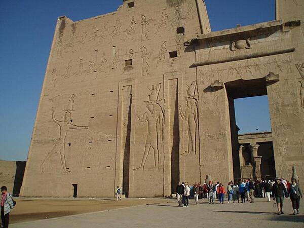
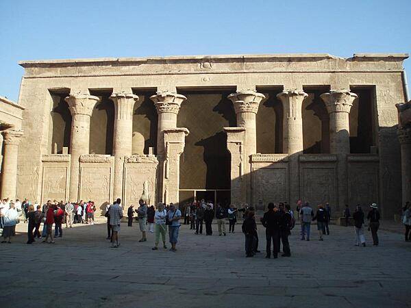
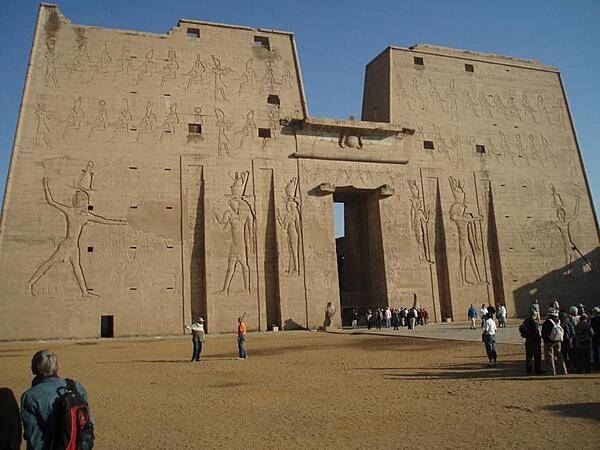
Pylon at the temple complex of Edfu. The temple, dedicated to the falcon god Horus, was built between 237 and 57 B.C.
Pylon at the temple complex of Edfu. The temple, dedicated to the falcon god Horus, was built between 237 and 57 B.C. • CIA World Factbook • 2020
Chapel at the Temple of Meharakka at Wadi el Seboua dedicated to the gods Isis (Hathor) and Serapis.
Chapel at the Temple of Meharakka at Wadi el Seboua dedicated to the gods Isis (Hathor) and Serapis. • CIA World Factbook • 2020
Hypostyle hall of the Temple of Meharakka at Wadi el Seboua dedicated to the gods Isis (Hathor) and Serapis. It is the only temple to have a winding staircase.
Hypostyle hall of the Temple of Meharakka at Wadi el Seboua dedicated to the gods Isis (Hathor) and Serapis. It is the only temple to have a winding staircase. • CIA World Factbook • 2020

CIA World Factbook • 2020
CIA World Factbook • 2020
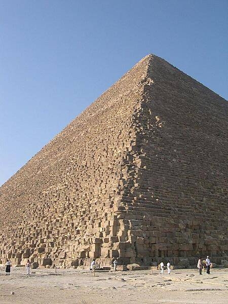
A view of a corner of the Khafre pyramid reveals its stair-step construction. The Great Pyramid of Khufu appears in the distance.
A view of a corner of the Khafre pyramid reveals its stair-step construction. The Great Pyramid of Khufu appears in the distance. • CIA World Factbook • 2020
CIA World Factbook • 2020
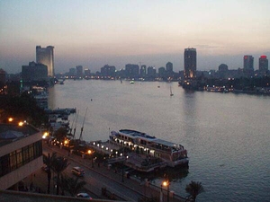
The Nile River in Cairo at dusk.
The Nile River in Cairo at dusk. • CIA World Factbook • 2020
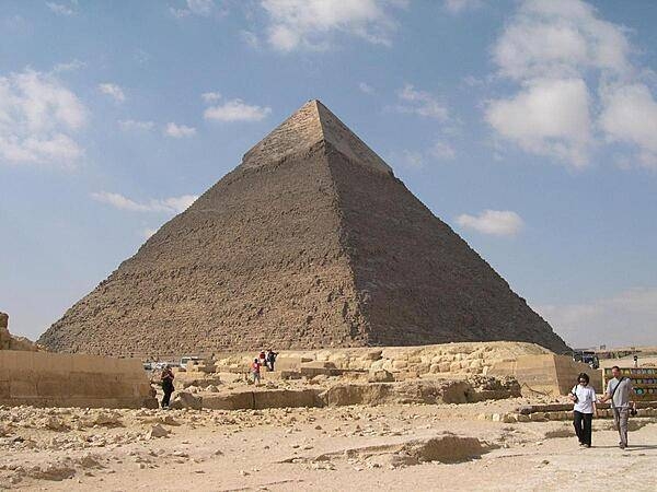
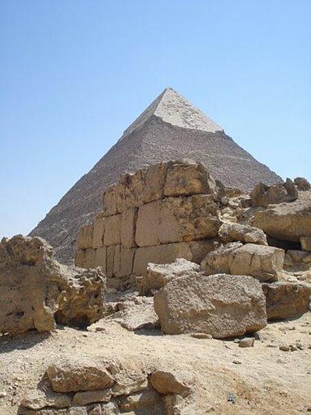
The Pyramid of Khafre is the second largest pyramid of Giza. Smooth casing stones still cover most of the upper portion of the pyramid.
The Pyramid of Khafre is the second largest pyramid of Giza. Smooth casing stones still cover most of the upper portion of the pyramid. • CIA World Factbook • 2020
The Temple of Queen Nefertari at Abu Simbel. The temple was moved to this location in the 1960s because of the rising waters of Lake Nasser.
The Temple of Queen Nefertari at Abu Simbel. The temple was moved to this location in the 1960s because of the rising waters of Lake Nasser. • CIA World Factbook • 2020
Pylons of the Temple of Horus at Edfu. The temple is mainly from the Ptolemaic period.
Pylons of the Temple of Horus at Edfu. The temple is mainly from the Ptolemaic period. • CIA World Factbook • 2020
CIA World Factbook • 2020
Temple of Ramses II at el Derr in Nubia. Carved into the rocks, the site was dedicated to the god Ra-Harakhte (Ra and Horus). The structure was moved to this location in the 1960s because of the rising waters of Lake Nasser.
Temple of Ramses II at el Derr in Nubia. Carved into the rocks, the site was dedicated to the god Ra-Harakhte (Ra and Horus). The structure was moved to this location in the 1960s because of the rising waters of Lake Nasser. • CIA World Factbook • 2020

Inscriptions on a wall at Kom Ombo showing the crocodile god Sobek and the falcon god Horus.
Inscriptions on a wall at Kom Ombo showing the crocodile god Sobek and the falcon god Horus. • CIA World Factbook • 2020
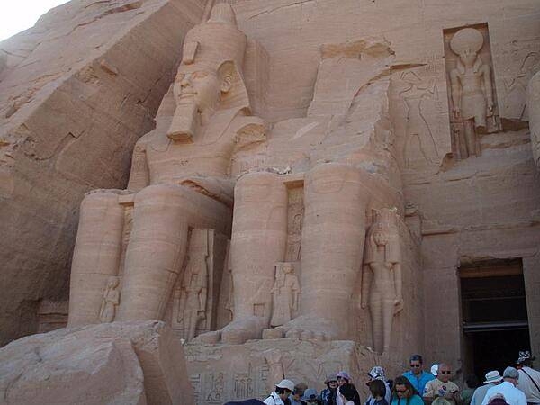
Right pylon of the Temple or Ramses II at Abu Simbel. The figures at the base of the colossi are the mother, wife and children of Ramses II. The figure above the entrance is the god, Ra-Harakhte (Ra and Horus).
Right pylon of the Temple or Ramses II at Abu Simbel. The figures at the base of the colossi are the mother, wife and children of Ramses II. The figure above the entrance is the god, Ra-Harakhte (Ra and Horus). • CIA World Factbook • 2020
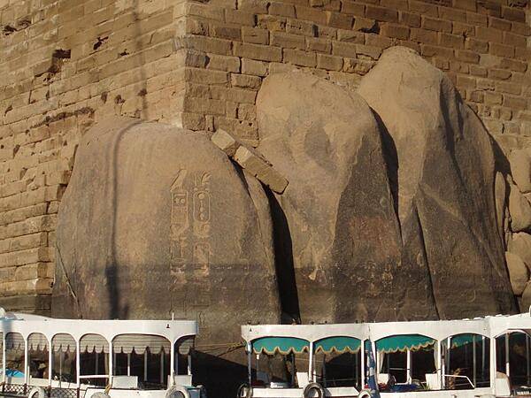
Elephantine Island is in the middle of the Nile River in Aswan. The rocks on the island resemble the rumps of a herd of elephants.
Elephantine Island is in the middle of the Nile River in Aswan. The rocks on the island resemble the rumps of a herd of elephants. • CIA World Factbook • 2020
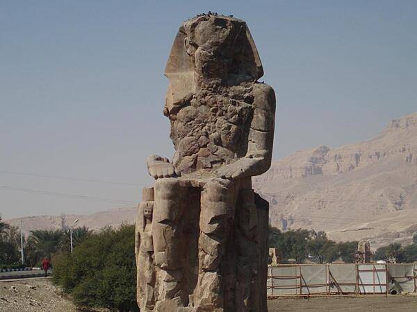
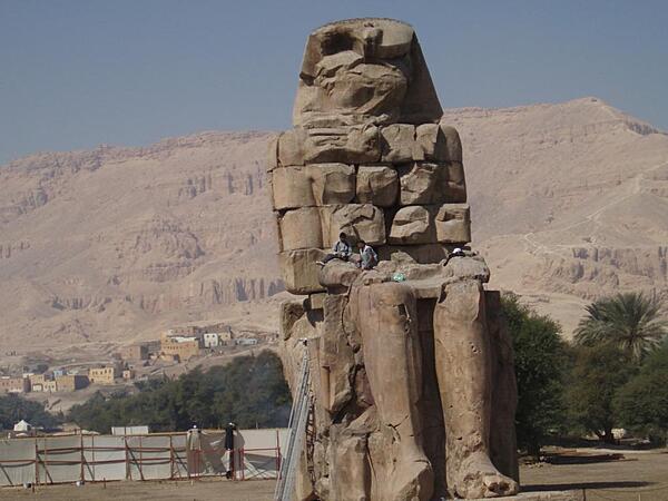
The second of a pair of 30-meter (50-ft) statues of Amenhotep III in the Theban Necropolis on the west bank of the Nile opposite Luxor.
The second of a pair of 30-meter (50-ft) statues of Amenhotep III in the Theban Necropolis on the west bank of the Nile opposite Luxor. • CIA World Factbook • 2020
The old dam in Aswan was built by the British between 1898 and 1902 using blocks of granite. It can hold up to 5.35 billion cu m (7 billion cu yd) of water.
The old dam in Aswan was built by the British between 1898 and 1902 using blocks of granite. It can hold up to 5.35 billion cu m (7 billion cu yd) of water. • CIA World Factbook • 2020
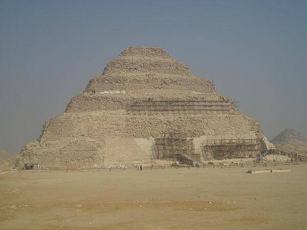
Step Pyramid of Pharaoh Djoser at Saqqara built by the architect Imhotep in the 3rd Dynasty (2649-2575 B.C.). It was the first stone pyramid in the world and was made up of a series of six buildings or mastabas (benches) placed on top of each other.
Step Pyramid of Pharaoh Djoser at Saqqara built by the architect Imhotep in the 3rd Dynasty (2649-2575 B.C.). It was the first stone pyramid in the world and was made up of a series of six buildings or mastabas (benches) placed on top of each other. • CIA World Factbook • 2020
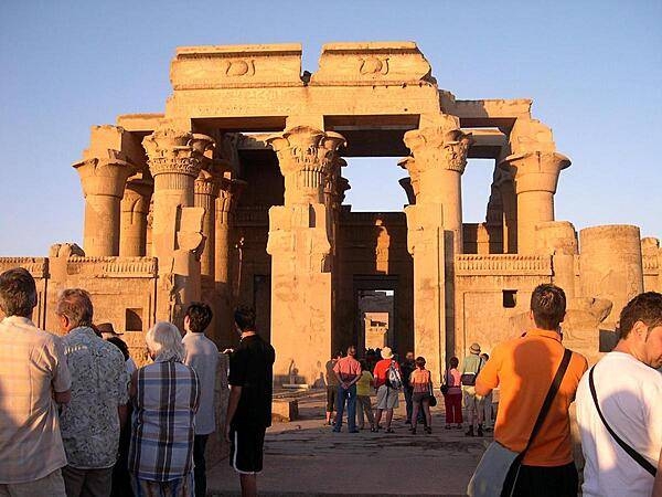
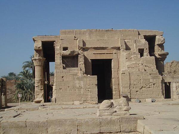
The Temple of Kom Ombo is an unusual double temple built during the Ptolemaic Period. The southern part is dedicated to the crocodile god Sobek, and the northern part is dedicated to Haroeris as a manifestation of Horus the falcon god.
The Temple of Kom Ombo is an unusual double temple built during the Ptolemaic Period. The southern part is dedicated to the crocodile god Sobek, and the northern part is dedicated to Haroeris as a manifestation of Horus the falcon god. • CIA World Factbook • 2020

CIA World Factbook • 2020
CIA World Factbook • 2020
Temple ruins before the Pyramid of Khafre.
Temple ruins before the Pyramid of Khafre. • CIA World Factbook • 2020
CIA World Factbook • 2020
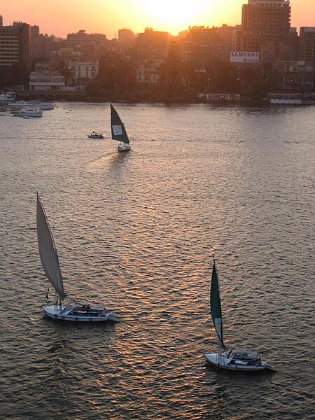
Sailboats on the Nile in Cairo.
Sailboats on the Nile in Cairo. • CIA World Factbook • 2020
A closer view of one of the statues of Ramses at Abu Simbel shows Nefertari, his wife, at his knee.
A closer view of one of the statues of Ramses at Abu Simbel shows Nefertari, his wife, at his knee. • CIA World Factbook • 2020
Cruising through Cairo on the Nile. The 187 m high Cairo Tower (concrete TV tower) on the far right is 48 m higher than the Great Pyramid at Giza.
Cruising through Cairo on the Nile. The 187 m high Cairo Tower (concrete TV tower) on the far right is 48 m higher than the Great Pyramid at Giza. • CIA World Factbook • 2020
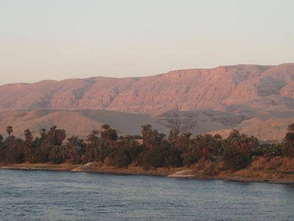
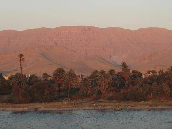
View along the Nile River at sunset south of Luxor. The land is green close to the river where is can be irrigated. Otherwise, it is desert.
View along the Nile River at sunset south of Luxor. The land is green close to the river where is can be irrigated. Otherwise, it is desert. • CIA World Factbook • 2020
The Pyramid of Menkaure at Giza is flanked by the smaller pyramids of his wives.
The Pyramid of Menkaure at Giza is flanked by the smaller pyramids of his wives. • CIA World Factbook • 2020
Relief at the Temple of Haroeris and Sobek at Kom Ombo showing gods. Almost all remains at the temple are from the Ptolemaic period.
Relief at the Temple of Haroeris and Sobek at Kom Ombo showing gods. Almost all remains at the temple are from the Ptolemaic period. • CIA World Factbook • 2020
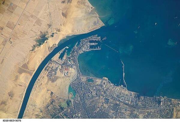
The Port of Suez - here viewed from the International Space Station - is located in Egypt along the northern coastline of the Gulf of Suez. The port and city are the southern terminus of the Suez Canal that transits through Egypt and debouches into the Mediterranean Sea near Port Said. The port serves vessels transporting general cargo, oil tankers, and both commercial and private passenger vessels. Several large vessels are visible in the Gulf of Suez and berthed at various docks around the port. Photo courtesy of NASA.
The Port of Suez - here viewed from the International Space Station - is located in Egypt along the northern coastline of the Gulf of Suez. The port and city are the southern terminus of the Suez Canal that transits through Egypt and debouches into the Mediterranean Sea near Port Said. The port serves vessels transporting general cargo, oil tankers, and both commercial and private passenger vessels. Several large vessels are visible in the Gulf of Suez and berthed at various docks around the port. Photo courtesy of NASA. • CIA World Factbook • 2020
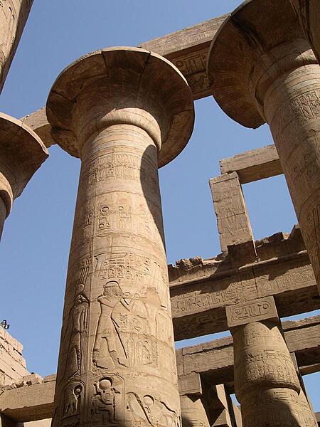
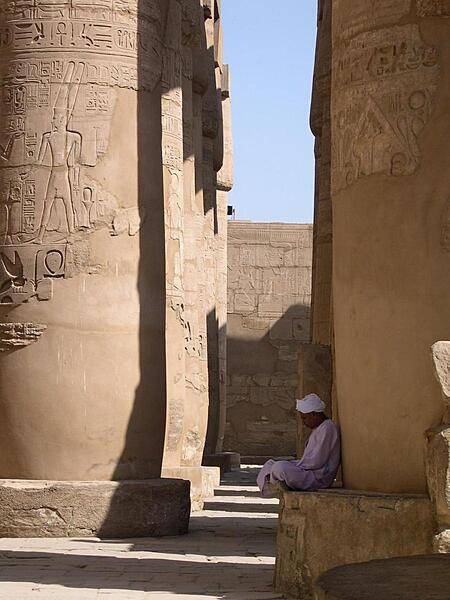
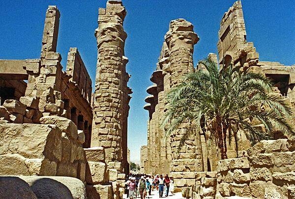
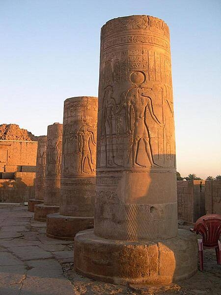
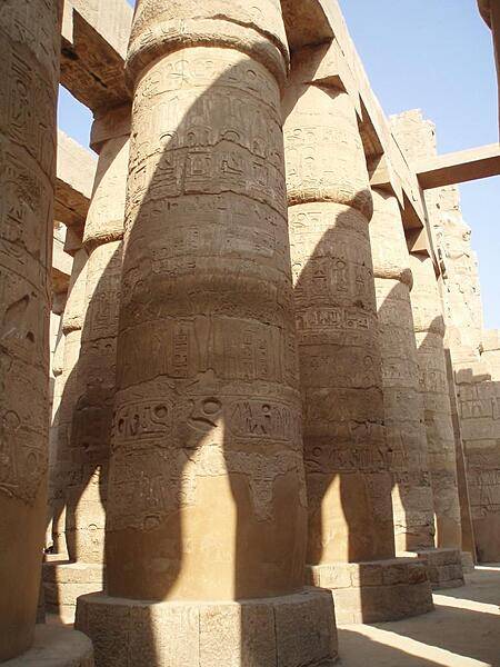
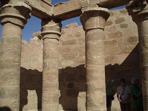
Some of the beautifully decorated columns of the Great Hypostyle Hall, part of the Karnak temple complex at Thebes. The Karnak religious site was the largest in the ancient world - it is sometimes referred to as the Vatican of Egypt - and was composed of four precincts - the one to Amun-Re is the only one open to the public.
Some of the beautifully decorated columns of the Great Hypostyle Hall, part of the Karnak temple complex at Thebes. The Karnak religious site was the largest in the ancient world - it is sometimes referred to as the Vatican of Egypt - and was composed of four precincts - the one to Amun-Re is the only one open to the public. • CIA World Factbook • 2020
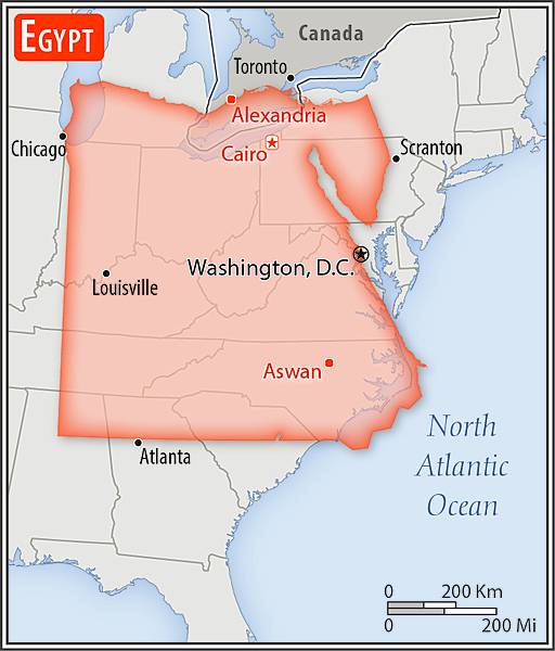
Area comparison map
Area comparison map • CIA World Factbook • 2020
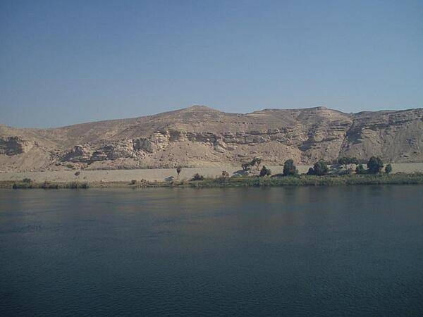
View along the Nile River south of Edfu.
View along the Nile River south of Edfu. • CIA World Factbook • 2020
Media source: CIA World Factbook (2020) — Public Domain