›››
Fiji
Fiji
Population
928.8K
Rank #161Source: World Bank
Capital
Suva
Source: REST Countries
Region
Oceania
East Asia & Pacific
Source: REST Countries
GDP (Nominal)
$5.97B
Rank #158Source: World Bank
Land Area
18.3K km²
Rank #153Source: REST Countries
Life Expectancy
67.316 yrs
Source: World Bank
Historical Trends
Population Trend (5-Year)
Source: World Bank
GDP Trend (5-Year, Nominal USD)
Source: World Bank
Geography
Area: 18,272 km²
Landlocked: No
Independent: Yes
Climate: tropical marine; only slight seasonal temperature variation
Terrain: mostly mountains of volcanic origin
Elevation: lowest point: Pacific Ocean 0 m highest point: Tomanivi 1,324 m
Natural Hazards: cyclonic storms can occur from November to January
Environmental Issues: the widespread practice of waste incineration is a major contributor to air pollution in the country, as are vehicle emissions in urban areas; deforestation and soil erosion are significant problems;...
Land Use: agricultural land: 23.3% (2011 est.) forest: 55.7% (2011 est.) other: 21% (2011 est.)
Geography Note: includes 332 islands; approximately 110 are inhabited
Natural Resources
timberfishgoldcopperoffshore oil potentialhydropower
People & Society
Fertility Rate
2.28
Population
928.8K
Ethnic Groups
iTaukei (56.8%)Indo-Fijian (37.5%)Rotuman (1.2%)other (4.5%)
Religions
Protestant 45% (Methodist (34.6%)Assembly of God (5.7%)Seventh Day Adventist (3.9%)and Anglican (0.8%)Hindu (27.9%)other Christian (10.4%)Roman Catholic (9.1%)Muslim (6.3%)Sikh (0.3%)other (0.3%)none (0.8%)
Economy
GDP per Capita
$6,425.742
GDP per Capita PPP
15,450.299
(2024)
(2024)
GNI per Capita
5,820
(2024)
(2024)
Gini Index
30.7
(2019)
(2019)
Unemployment
5.361%
(2024)
(2024)
Inflation
4.511%
(2024)
(2024)
Public Debt
Not Available
Energy
Electricity Access
99.3%
(2023)
(2023)
Renewable Energy
28.4%
(2022)
(2022)
CO₂ Emissions
1.507 Mt
(2024)
(2024)
Energy Intensity
2.15 MJ/$
(2022)
(2022)
Renewable Electricity
60.066%
(2021)
(2021)
Environment
Forest Coverage
63.495% of land
(2023)
(2023)
Protected Areas
0.18% of land
(2009)
(2009)
Communications
Internet Users
79.349%
(2023)
(2023)
Mobile Penetration
111.749%
(2022)
(2022)
Broadband Subscribers
2.534%
(2022)
(2022)
Transportation
Air Transport Freight
156.08 M ton-km
(2023)
(2023)
Container Port Traffic
145,782.4 TEU
(2019)
(2019)
Airports
26,145
Rail Lines
N/A
Roads Total
N/A
Military
Military Forces
Republic of Fiji Military Forces (RFMF): Land Force Command, Maritime Command
Personnel Strength
the Republic of Fiji Military Forces (RFMF) have about 3,500 personnel (3,200 Land Force; 300 Maritime Command)
Military Expenditure (USD)
$0.08B
Military Expenditure (% of GDP)
1.31%
Military Expenditure History
1.6% of GDP (2019) 1.6% of GDP (2018) 1.5% of GDP (2017) 1.2% of GDP (2016) 1% of GDP (2015)
Deployments
170 Egypt (MFO); 170 Iraq (UNAMI); 130 Golan Heights (UNDOF) (2020)
Equipment & Inventories
the RFMF's small inventory is a mix of equipment from Australia, New Zealand, Russia, Singapore, South Korea, the UK, and the US; since 2010, the only recorded arms deliveries were from Australia;...
Service Age & Obligation
18 years of age for voluntary military service; mandatory retirement at age 55
Education
Pre-Primary Enrollment
31.34%
(2021)
(2021)
Primary Enrollment
110.377%
(2024)
(2024)
Secondary Enrollment
98.093%
(2024)
(2024)
Tertiary Enrollment
75.009%
(2024)
(2024)
Education Spending
4.247% of GDP
(2023)
(2023)
Pupil-Teacher Ratio
27.997:1
(2012)
(2012)
Health
Physicians per 1,000
0.813
(2015)
(2015)
Safe Water Access
95.56%
(2024)
(2024)
Safe Drinking Water
42.111%
(2024)
(2024)
Under-5 Mortality
29.1 per 1,000
(2023)
(2023)
Maternal Mortality (World Bank)
14.479 per 100,000
(2021)
(2021)
Hospital Beds per 1,000
65.501
(2021)
(2021)
UHC Coverage Index
69
(2023)
(2023)
Measles Immunization
94%
(2024)
(2024)
Social Indicators
Extreme Poverty Rate
4.7%
(2019)
(2019)
Food Insecurity
6.8%
(2023)
(2023)
Youth NEET Rate
16.535%
(2024)
(2024)
Governance
Women in Government
9.091%
(2024)
(2024)
Voice & Accountability
0.19
(Above Average)
(2023)
(Above Average)
(2023)
Political Stability
0.74
(Above Average)
(2023)
(Above Average)
(2023)
Government Effectiveness
0.49
(Above Average)
(2023)
(Above Average)
(2023)
Regulatory Quality
-0.09
(Below Average)
(2023)
(Below Average)
(2023)
Rule of Law
0.30
(Above Average)
(2023)
(Above Average)
(2023)
Control of Corruption
0.51
(Above Average)
(2023)
(Above Average)
(2023)
Government
Government Type
parliamentary republic
Legal System
common law system based on the English model
Executive Branch
chief of state: President Jioji Konousi KONROTE (since 12 November 2015) head of government: Prime Minister Voreqe "Frank" BAINIMARAMA (since 22 September 2014) cabinet: Cabinet appointed by the...
Legislative Branch
description: unicameral Parliament (51 seats; members directly elected in a nationwide, multi-seat constituency by open-list proportional representation vote to serve 4-year terms) elections: last...
Judicial Branch
highest courts: Supreme Court (consists of the chief justice, all justices of the Court of Appeal, and judges appointed specifically as Supreme Court judges); Court of Appeal (consists of the court...
National Symbols
Flag Description
light blue with the flag of the UK in the upper hoist-side quadrant and the Fijian shield centered on the outer half of the flag; the blue symbolizes the Pacific Ocean and the Union Jack reflects the...
National Symbols
Fijian canoe; national color: light blue
National Anthem
name: God Bless Fiji lyrics/music: Michael Francis Alexander PRESCOTT/C. Austin MILES (adapted by Michael Francis Alexander PRESCOTT) note: adopted 1970; known in Fijian as "Meda Dau Doka" (Let Us...
Safety
Homicide Rate
2.056 per 100,000
(2023)
(2023)
Travel Information
Language(s): English, Fijian, Fiji Hindi
Currency: FJD ($)
Timezone(s): UTC+12:00
Landlocked: No
Independent: Yes
Driving Side: Left
Calling Code: +679
Car Sign: FJI
Week Starts: Monday
Photos
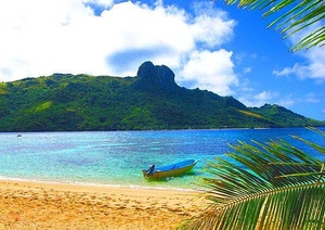
A beach on the island of Kuata, the smallest of the Yasawa Islands Group. Tourism is of growing importance to the island's economy; its deep lagoon is excellent for swimming and snorkeling.
A beach on the island of Kuata, the smallest of the Yasawa Islands Group. Tourism is of growing importance to the island's economy; its deep lagoon is excellent for swimming and snorkeling. • CIA World Factbook • 2020
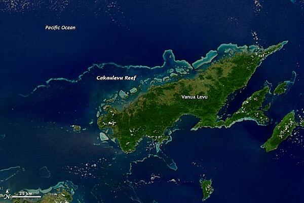
This satellite image shows Fiji's second-largest island, Vanua Levu, and the Cakaulevu Reef that shelters the island's northern shore. Also called the Great Sea Reef, Cakaulevu shines turquoise through clear, shallow waters. It is the third longest continuous barrier reef in the world, behind the Great Barrier Reef in Australia and the Mesoamerica Reef off Central America. When combined with the nearby Pascoe Reef, Cakaulevu Reef is about 200 km (120 mi) long. On its own, the Cakaulevu Reef covers 202,700 sq km (77,200 sq mi). The first systematic survey of the reef (in 2004) revealed a diverse marine population, including unique mangrove ecosystems and endemic fish. Twelve threatened species live within the reef: 10 fish species, the green turtle, and the spinner dolphin. All of this marine life has traditionally supported the native population, and currently some 70,000 people depend on the reef. After seeing fish populations decline in recent decades, local leaders created a series of marine protected areas in 2005 where fishing is prohibited. Where the ban has been enforced, fish populations have rebounded and spilled over into areas where fishing is permitted. Photo courtesy of NASA.
This satellite image shows Fiji's second-largest island, Vanua Levu, and the Cakaulevu Reef that shelters the island's northern shore. Also called the Great Sea Reef, Cakaulevu shines turquoise through clear, shallow waters. It is the third longest continuous barrier reef in the world, behind the Great Barrier Reef in Australia and the Mesoamerica Reef off Central America. When combined with the nearby Pascoe Reef, Cakaulevu Reef is about 200 km (120 mi) long. On its own, the Cakaulevu Reef covers 202,700 sq km (77,200 sq mi).
The first systematic survey of the reef (in 2004) revealed a diverse marine population, including unique mangrove ecosystems and endemic fish. Twelve threatened species live within the reef: 10 fish species, the green turtle, and the spinner dolphin. All of this marine life has traditionally supported the native population, and currently some 70,000 people depend on the reef. After seeing fish populations decline in recent decades, local leaders created a series of marine protected areas in 2005 where fishing is prohibited. Where the ban has been enforced, fish populations have rebounded and spilled over into areas where fishing is permitted. Photo courtesy of NASA. • CIA World Factbook • 2020
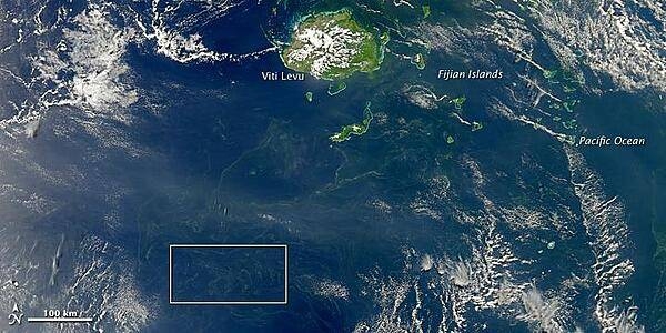
It is hard to believe, but some of the smallest organisms on our planet can be viewed from space. Diminutive bacteria and plankton (microscopic, floating plants) can merge into great chains and mats that can be detected by satellites hundreds of kilometers up. NASA's Aqua satellite captured this image of a plankton or bacterial bloom south of Fiji on 18 October 2010. Photo courtesy of NASA.
It is hard to believe, but some of the smallest organisms on our planet can be viewed from space. Diminutive bacteria and plankton (microscopic, floating plants) can merge into great chains and mats that can be detected by satellites hundreds of kilometers up. NASA's Aqua satellite captured this image of a plankton or bacterial bloom south of Fiji on 18 October 2010. Photo courtesy of NASA. • CIA World Factbook • 2020
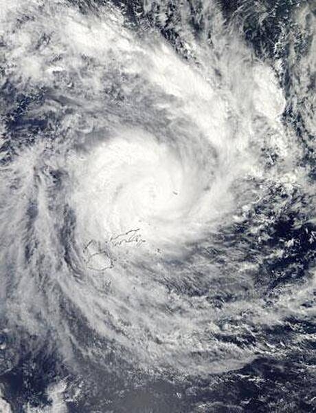
NASA's Aqua satellite passed over Tropical Cyclone Evan on 16 December 2012 and captured this true-color image of the intense storm over the island nation of Fiji. In this image, the storm contains a large, cloud-filled eye, which was estimated at about 17 km (11 mi) across. Heavy rain bands wrap in an apostrophe shape around the center, and reach over the two main islands of Fiji, Viti Levu (south) and Vanua Levu (north). Tropical Cyclone Evan was one of the strongest cyclones to hit Fiji and Samoa in recent memory. In the ten days between first formation on 9 December and dissipation on 19 December, the storm battered Fiji, Western Samoa, American Samoa, Tonga, and Wallis and Futuna. The estimated cost of the storm was $161 million US dollars, and 14 lives were reported lost. Photo courtesy of NASA.
NASA's Aqua satellite passed over Tropical Cyclone Evan on 16 December 2012 and captured this true-color image of the intense storm over the island nation of Fiji. In this image, the storm contains a large, cloud-filled eye, which was estimated at about 17 km (11 mi) across. Heavy rain bands wrap in an apostrophe shape around the center, and reach over the two main islands of Fiji, Viti Levu (south) and Vanua Levu (north). Tropical Cyclone Evan was one of the strongest cyclones to hit Fiji and Samoa in recent memory. In the ten days between first formation on 9 December and dissipation on 19 December, the storm battered Fiji, Western Samoa, American Samoa, Tonga, and Wallis and Futuna. The estimated cost of the storm was $161 million US dollars, and 14 lives were reported lost. Photo courtesy of NASA. • CIA World Factbook • 2020
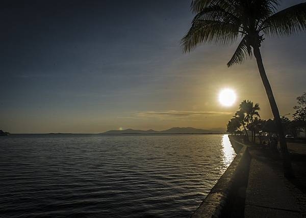
The sun rises over the horizon as waves lap the seawall in Lautoka, the second largest city in Fiji. Lautoka is on the west coast of the island of Viti Levu, in the Ba Province. Photo courtesy of the US Air Force/ Tech. Sgt. Benjamin Stratton.
The sun rises over the horizon as waves lap the seawall in Lautoka, the second largest city in Fiji. Lautoka is on the west coast of the island of Viti Levu, in the Ba Province. Photo courtesy of the US Air Force/ Tech. Sgt. Benjamin Stratton. • CIA World Factbook • 2020
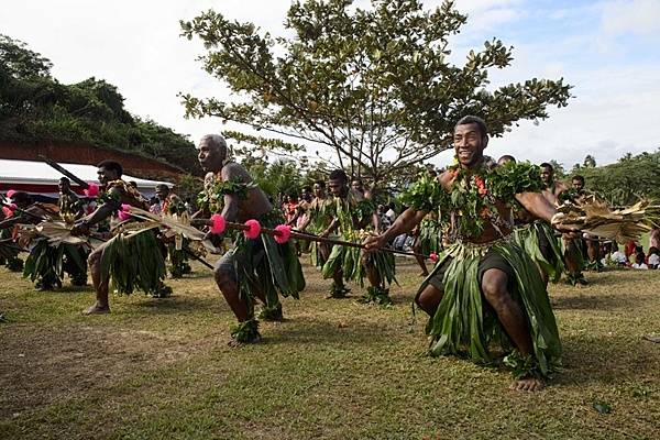
Fijians perform a traditional dance on Vanua Levu on 17 June 2015 for the crew of the hospital ship USNS Mercy (T-AH 19) as part of a ceremony during Pacific Partnership 2015. US and Fijian engineers worked together to build a new classroom at the Viani Primary School and celebrated with a ribbon cutting ceremony. Photo courtesy of the US Navy/ Chief Mass Communication Specialist Christopher E. Tucker.
Fijians perform a traditional dance on Vanua Levu on 17 June 2015 for the crew of the hospital ship USNS Mercy (T-AH 19) as part of a ceremony during Pacific Partnership 2015. US and Fijian engineers worked together to build a new classroom at the Viani Primary School and celebrated with a ribbon cutting ceremony. Photo courtesy of the US Navy/ Chief Mass Communication Specialist Christopher E. Tucker. • CIA World Factbook • 2020
8 photos available
View All Photos→Data sources: World Bank, UN Data • Updated daily •Learn about our data