›››
Micronesia, Fed. Sts.
Micronesia, Fed. Sts.
Population
113.2K
Rank #190Source: World Bank
Capital
Palikir
Source: REST Countries
Region
Oceania
East Asia & Pacific
Source: REST Countries
GDP (Nominal)
$471.43M
Rank #189Source: World Bank
Land Area
702 km²
Rank #185Source: REST Countries
Life Expectancy
67.198 yrs
Source: World Bank
Historical Trends
Population Trend (5-Year)
Source: World Bank
GDP Trend (5-Year, Nominal USD)
Source: World Bank
People & Society
Fertility Rate
2.75
Population
113.2K
Economy
GDP per Capita
$4,166.005
GDP per Capita PPP
4,346.842
(2024)
(2024)
GNI per Capita
4,240
(2024)
(2024)
Gini Index
40.1
(2013)
(2013)
Unemployment
Not Available
Inflation
5.409%
(2022)
(2022)
Public Debt
27.796%
(2020)
(2020)
Energy
Electricity Access
86.9%
(2023)
(2023)
Renewable Energy
2%
(2022)
(2022)
CO₂ Emissions
Not Available
Energy Intensity
6.62 MJ/$
(2022)
(2022)
Renewable Electricity
4.948%
(2021)
(2021)
Environment
Forest Coverage
92.157% of land
(2023)
(2023)
Protected Areas
28% of land
(2010)
(2010)
Communications
Internet Users
39.383%
(2020)
(2020)
Mobile Penetration
19.989%
(2022)
(2022)
Broadband Subscribers
5.818%
(2022)
(2022)
Transportation
Air Transport Freight
Not Available
Container Port Traffic
25,234.09 TEU
(2019)
(2019)
Airports
N/A
Rail Lines
N/A
Roads Total
N/A
Education
Pre-Primary Enrollment
5.886%
(2021)
(2021)
Primary Enrollment
82.16%
(2024)
(2024)
Secondary Enrollment
Not Available
Tertiary Enrollment
Not Available
Education Spending
11.559% of GDP
(2020)
(2020)
Pupil-Teacher Ratio
19.711:1
(2015)
(2015)
Health
Physicians per 1,000
0.974
(2020)
(2020)
Safe Water Access
89.882%
(2020)
(2020)
Safe Drinking Water
Not Available
Under-5 Mortality
23.1 per 1,000
(2023)
(2023)
Maternal Mortality (World Bank)
14.768 per 100,000
(2021)
(2021)
Hospital Beds per 1,000
62.985
(2021)
(2021)
UHC Coverage Index
65
(2023)
(2023)
Measles Immunization
76%
(2024)
(2024)
Social Indicators
Extreme Poverty Rate
26.1%
(2013)
(2013)
Food Insecurity
Not Available
Youth NEET Rate
18.878%
(2014)
(2014)
Governance
Women in Government
15.385%
(2024)
(2024)
Voice & Accountability
1.08
(Strong)
(2023)
(Strong)
(2023)
Political Stability
1.08
(Strong)
(2023)
(Strong)
(2023)
Government Effectiveness
0.23
(Above Average)
(2023)
(Above Average)
(2023)
Regulatory Quality
-0.58
(Below Average)
(2023)
(Below Average)
(2023)
Rule of Law
0.64
(Above Average)
(2023)
(Above Average)
(2023)
Control of Corruption
0.78
(Above Average)
(2023)
(Above Average)
(2023)
Government
National Symbols
Safety
Homicide Rate
0.907 per 100,000
(2019)
(2019)
Travel Information
Language(s): English
Currency: USD ($)
Timezone(s): UTC +10:00 to +11:00
Landlocked: No
Independent: Yes
Driving Side: Right
Calling Code: +691
Car Sign: FSM
Week Starts: Monday
Photos
CIA World Factbook • 2020
CIA World Factbook • 2020
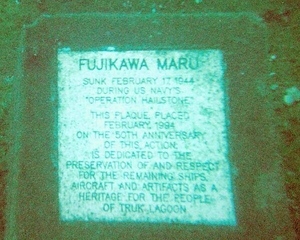
Underwater plaque in Chuuk (Truk) Lagoon.
Underwater plaque in Chuuk (Truk) Lagoon. • CIA World Factbook • 2020
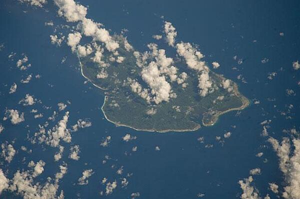
The State of Kosrae is the easternmost of the four states that make up the Federated States of Micronesia; it includes the main island of Kosrae and about a dozen nearby islands and islets. The island is located approximately 600 Km (370 mi) north of the equator, between Guam and the Hawaiian Islands. Its land area is approximately 110 sq km (42 sq mi). Image courtesy of NASA.
The State of Kosrae is the easternmost of the four states that make up the Federated States of Micronesia; it includes the main island of Kosrae and about a dozen nearby islands and islets. The island is located approximately 600 Km (370 mi) north of the equator, between Guam and the Hawaiian Islands. Its land area is approximately 110 sq km (42 sq mi). Image courtesy of NASA. • CIA World Factbook • 2020
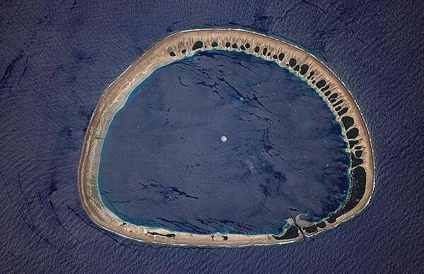
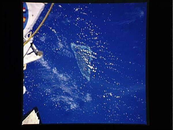
Classically shaped Nukuoro Atoll is one of 607 islands that make up the Federated States of Micronesia. It is also a municipality of the state of Pohnpei, Federated States of Micronesia. The atoll has a population of only several hundred people. The total area, including the lagoon, is 40 sq km, with a land area of only 1.7 sq km, which is divided among more than 40 islets that lie on the northern, eastern, and southern sides of the lagoon. By far the largest islet is Nukuoro islet in the southeast, which is the center of population and the capital of the municipality. Vegetation is most prominent on the northeast and east portions of the atoll that face the dominant Easterly winds. Swells driven by these winds can be seen approaching from the east-southeast (right) and wrapping around the atoll to produce an interference pattern on the downwind side. Water in the lagoon is calm in comparison. A coral head appears dead center of the photo. Image courtesy of NASA.
Classically shaped Nukuoro Atoll is one of 607 islands that make up the Federated States of Micronesia. It is also a municipality of the state of Pohnpei, Federated States of Micronesia. The atoll has a population of only several hundred people. The total area, including the lagoon, is 40 sq km, with a land area of only 1.7 sq km, which is divided among more than 40 islets that lie on the northern, eastern, and southern sides of the lagoon. By far the largest islet is Nukuoro islet in the southeast, which is the center of population and the capital of the municipality. Vegetation is most prominent on the northeast and east portions of the atoll that face the dominant Easterly winds. Swells driven by these winds can be seen approaching from the east-southeast (right) and wrapping around the atoll to produce an interference pattern on the downwind side. Water in the lagoon is calm in comparison. A coral head appears dead center of the photo. Image courtesy of NASA. • CIA World Factbook • 2020

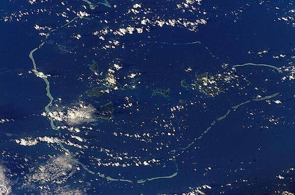
Pohnpei (on the right) is the largest, highest, most populous, and most developed single island in the Federated States of Micronesia. The islanders of Pohnpei have a reputation as being the most welcoming of outsiders among residents of the island group. Pohnpei also contains a wealth of biodiversity and is one of the wettest places on earth with annual recorded rainfall exceeding 7.6 m (25 ft) each year in certain mountainous locations. Image courtesy of NASA.
Pohnpei (on the right) is the largest, highest, most populous, and most developed single island in the Federated States of Micronesia. The islanders of Pohnpei have a reputation as being the most welcoming of outsiders among residents of the island group. Pohnpei also contains a wealth of biodiversity and is one of the wettest places on earth with annual recorded rainfall exceeding 7.6 m (25 ft) each year in certain mountainous locations. Image courtesy of NASA. • CIA World Factbook • 2020
9 photos available
View All Photos→Data sources: World Bank, UN Data • Updated daily •Learn about our data