›››
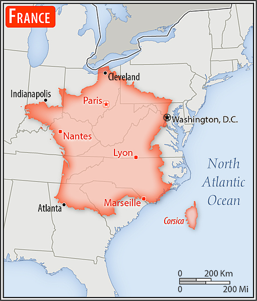
France — Media Gallery
132 items available (flags, maps, photos)
Photos
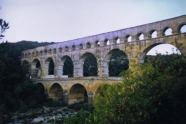
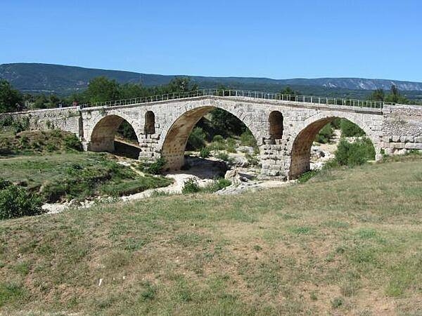
The Roman aqueduct at Pont du Gard, built during the mid-first century A.D., was part of a 50 km (30 mi) long aqueduct system that brought water to the city of Nemausus (today's Nimes). Built entirely without the use of mortar, its construction is thought to have taken about three years using 800 to 1,000 workers.
The Roman aqueduct at Pont du Gard, built during the mid-first century A.D., was part of a 50 km (30 mi) long aqueduct system that brought water to the city of Nemausus (today's Nimes). Built entirely without the use of mortar, its construction is thought to have taken about three years using 800 to 1,000 workers. • CIA World Factbook • 2020
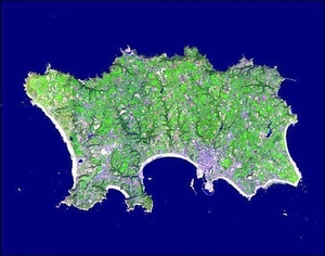
The Isle of Jersey (officially called the Bailiwick of Jersey) is the largest of the Channel Islands in the Bay of Mont St. Michel off the northwest coast of France. This Terra satellite image vividly displays the island's agricultural patchwork terrain. Image courtesy of NASA.
The Isle of Jersey (officially called the Bailiwick of Jersey) is the largest of the Channel Islands in the Bay of Mont St. Michel off the northwest coast of France. This Terra satellite image vividly displays the island's agricultural patchwork terrain. Image courtesy of NASA. • CIA World Factbook • 2020
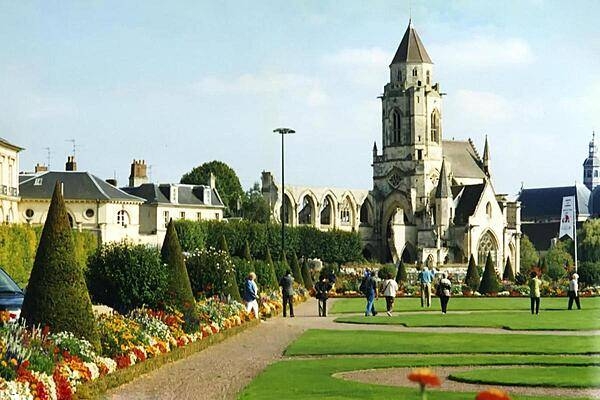
Gardens before the Church of St. Etienne in Caen. Formerly referred to as the Men's Abbey, the structure was completed in 1063 and is now dedicated to St. Stephen.
Gardens before the Church of St. Etienne in Caen. Formerly referred to as the Men's Abbey, the structure was completed in 1063 and is now dedicated to St. Stephen. • CIA World Factbook • 2020
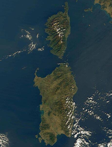
Rich in antiquities and picturesque landscapes, the island provinces of Corsica, France, (top) and Sardinia, Italy, (bottom) have captured the imaginations of historians and poets alike for centuries. Corsica, crowned with snow-capped mountains, jeweled with shimmering lakes, and cloaked in misty emerald forests, is situated in the Mediterranean Sea southeast of mainland France. The island has almost 1,700 hills and mountains, and is carved by an extensive network of rivers. Across the Strait of Bonifacio to the south is Sardinia, the Mediterranean's second largest island. Stretching across the central, eastern part of Sardinia is the rugged terrain of Gennargentu - mountainous, thickly vegetated, and mostly uninhabited. The port city of Cagliari sits on the large bay on Sardinia's southern coast. Photo courtesy of NASA.
Rich in antiquities and picturesque landscapes, the island provinces of Corsica, France, (top) and Sardinia, Italy, (bottom) have captured the imaginations of historians and poets alike for centuries. Corsica, crowned with snow-capped mountains, jeweled with shimmering lakes, and cloaked in misty emerald forests, is situated in the Mediterranean Sea southeast of mainland France. The island has almost 1,700 hills and mountains, and is carved by an extensive network of rivers. Across the Strait of Bonifacio to the south is Sardinia, the Mediterranean's second largest island. Stretching across the central, eastern part of Sardinia is the rugged terrain of Gennargentu - mountainous, thickly vegetated, and mostly uninhabited. The port city of Cagliari sits on the large bay on Sardinia's southern coast. Photo courtesy of NASA. • CIA World Factbook • 2020
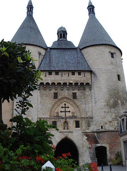
The Graffe Gate is one of the oldest remaining parts of Nancy's fortifications. It was erected in the 14th century, and its towers were used as prisons for many years. Its bell also formerly tolled the curfew. The facade displays a distinctive Lorraine Cross, since the city was the former capital of the Duchy of Lorraine.
The Graffe Gate is one of the oldest remaining parts of Nancy's fortifications. It was erected in the 14th century, and its towers were used as prisons for many years. Its bell also formerly tolled the curfew. The facade displays a distinctive Lorraine Cross, since the city was the former capital of the Duchy of Lorraine. • CIA World Factbook • 2020
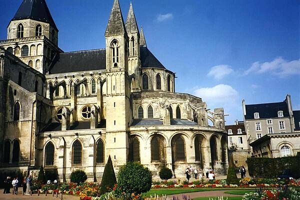
The Abbaye aux Hommes (Men's Abbey) is a Romanesque church dedicated to St. Etienne (St. Stephen) in Caen. Built by order of William the Conqueror, the former Benedictine abbey was completed in 1063.
The Abbaye aux Hommes (Men's Abbey) is a Romanesque church dedicated to St. Etienne (St. Stephen) in Caen. Built by order of William the Conqueror, the former Benedictine abbey was completed in 1063. • CIA World Factbook • 2020
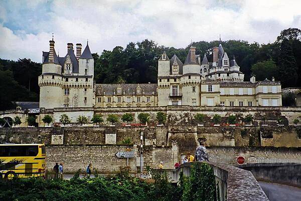
The Chateau d'Usse was rebuilt in the 15th century on a stronghold site dating back to the 11th century. By tradition, this is the castle Charles Perrault had in mind when he wrote the Sleeping Beauty fairy tale.
The Chateau d'Usse was rebuilt in the 15th century on a stronghold site dating back to the 11th century. By tradition, this is the castle Charles Perrault had in mind when he wrote the Sleeping Beauty fairy tale. • CIA World Factbook • 2020
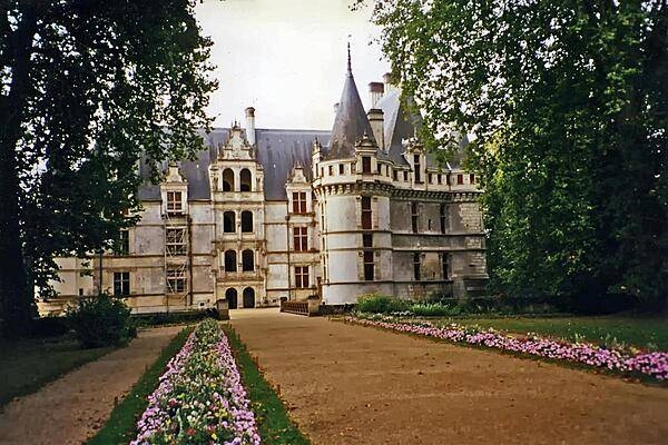
The Chateau d'Azay-le-Rideau was built on an island in the Indre River between 1515 and 1527 and is one of the earliest of French Renaissance chateaux.
The Chateau d'Azay-le-Rideau was built on an island in the Indre River between 1515 and 1527 and is one of the earliest of French Renaissance chateaux. • CIA World Factbook • 2020
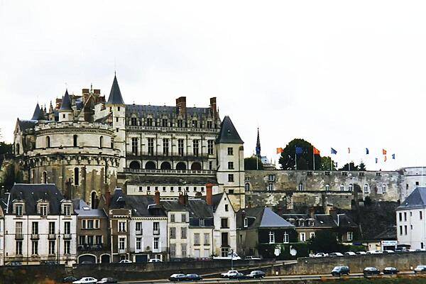
The royal Chateau d'Amboise in the Loire Valley was rebuilt in the late 15th century over a stronghold dating back to the 11th century.
The royal Chateau d'Amboise in the Loire Valley was rebuilt in the late 15th century over a stronghold dating back to the 11th century. • CIA World Factbook • 2020
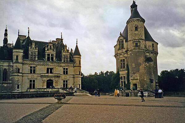
The Chateau de Chenonceau in the Loire Valley was built in the early 16th century. It is one of France's most popular tourist attractions.
The Chateau de Chenonceau in the Loire Valley was built in the early 16th century. It is one of France's most popular tourist attractions. • CIA World Factbook • 2020
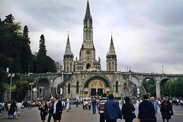
Pilgrims and visitors at Lourdes. The Rosary Basilica in the foreground serves as an entranceway to the larger Basilica of the Immaculate Conception behind. Lourdes is the reputed site of 18 Marian apparitions in 1858. The town is one of the world's greatest pilgrimage sites hosting some 5 million visitors annually.
Pilgrims and visitors at Lourdes. The Rosary Basilica in the foreground serves as an entranceway to the larger Basilica of the Immaculate Conception behind. Lourdes is the reputed site of 18 Marian apparitions in 1858. The town is one of the world's greatest pilgrimage sites hosting some 5 million visitors annually. • CIA World Factbook • 2020
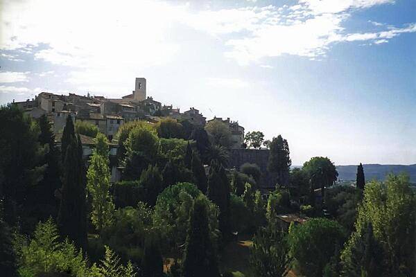
Approaching the fortified medieval town and artist's haven of Saint-Paul de Vence in Provence.
Approaching the fortified medieval town and artist's haven of Saint-Paul de Vence in Provence. • CIA World Factbook • 2020
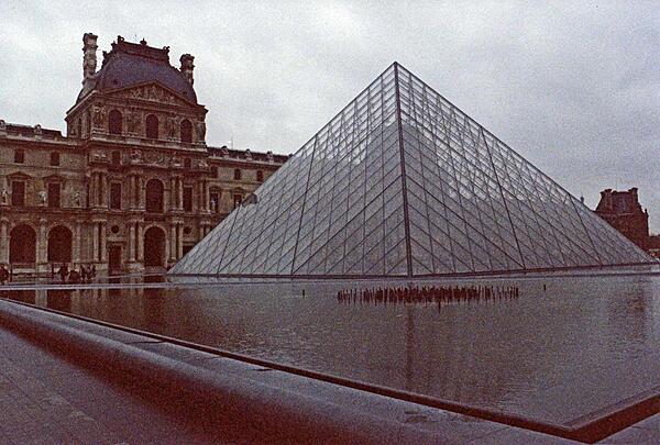
The Louvre Pyramid, built in 1989, serves as the main entrance to the Louvre, one of the world's largest and most visited museums. Objects dating from prehistory to the 19th century are on display there.
The Louvre Pyramid, built in 1989, serves as the main entrance to the Louvre, one of the world's largest and most visited museums. Objects dating from prehistory to the 19th century are on display there. • CIA World Factbook • 2020
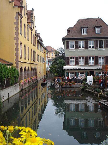
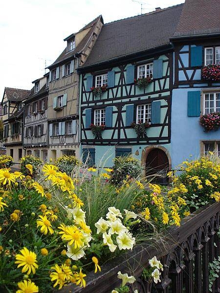
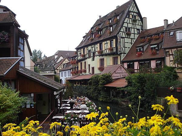
Buildings along a canal in Colmar, an Alsatian town known as "Little Venice." Situated on the Lauch River, Colmar connects to the Rhine via a canal.
Buildings along a canal in Colmar, an Alsatian town known as "Little Venice." Situated on the Lauch River, Colmar connects to the Rhine via a canal. • CIA World Factbook • 2020
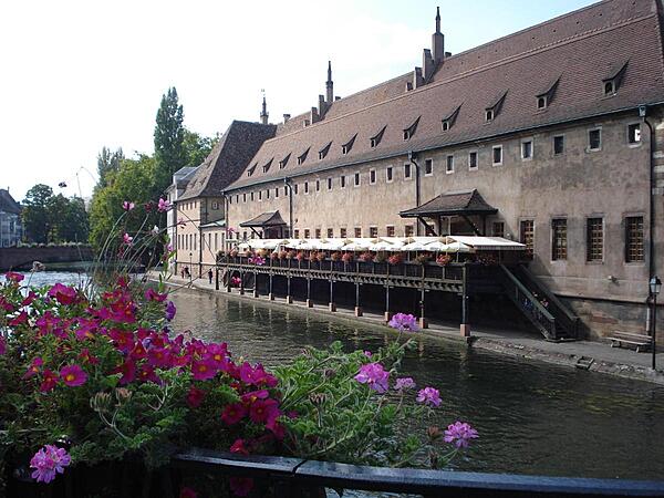
The old custom's building (L'Ancienne Douane) on the Grande Ile in Strasbourg. Constructed in 1358, the structure housed the port and tax authorities, and was used to store and transform goods and merchandise going up and down the Rhine River. Today the building houses a restaurant.
The old custom's building (L'Ancienne Douane) on the Grande Ile in Strasbourg. Constructed in 1358, the structure housed the port and tax authorities, and was used to store and transform goods and merchandise going up and down the Rhine River. Today the building houses a restaurant. • CIA World Factbook • 2020
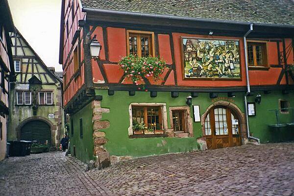
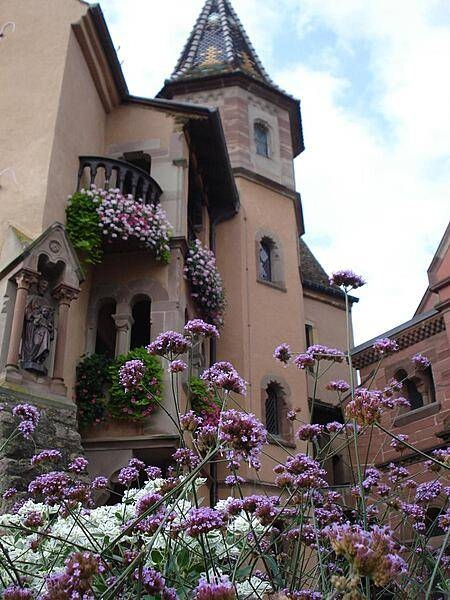
Colorful house in the medieval Alsatian town of Riquewihr. The locale is renowned not only for its historic architecture, but also for the fine wines it produces.
Colorful house in the medieval Alsatian town of Riquewihr. The locale is renowned not only for its historic architecture, but also for the fine wines it produces. • CIA World Factbook • 2020
CIA World Factbook • 2020
CIA World Factbook • 2020
CIA World Factbook • 2020
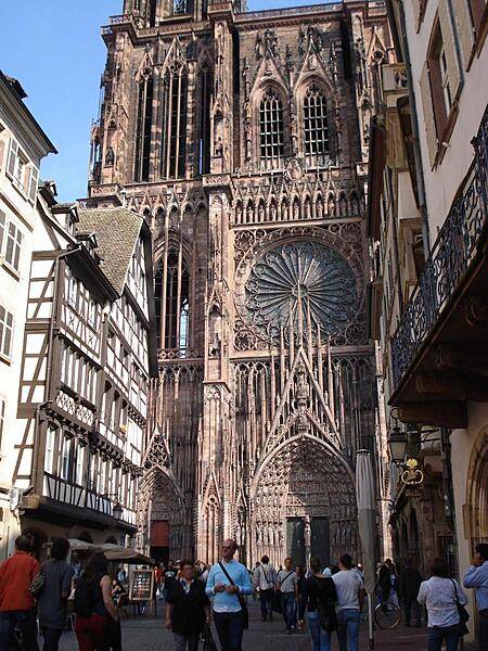
A view of the western side of Strasbourg Cathedral. Only one spire was ever completed.
A view of the western side of Strasbourg Cathedral. Only one spire was ever completed. • CIA World Factbook • 2020
CIA World Factbook • 2020
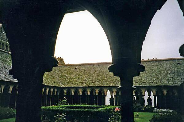
The cloisters at Mont-Saint-Michel.
The cloisters at Mont-Saint-Michel. • CIA World Factbook • 2020

CIA World Factbook • 2020
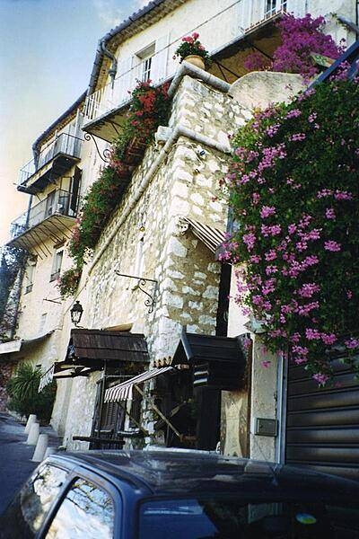
Flowers drip from balconies in the town of Saint-Paul de Vence in Provence.
Flowers drip from balconies in the town of Saint-Paul de Vence in Provence. • CIA World Factbook • 2020
CIA World Factbook • 2020
Area comparison map
Area comparison map • CIA World Factbook • 2020
Area comparison map
Area comparison map • CIA World Factbook • 2020
Area comparison map
Area comparison map • CIA World Factbook • 2020

Area comparison map
Area comparison map • CIA World Factbook • 2020
Area comparison map
Area comparison map • CIA World Factbook • 2020
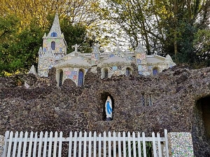
The Little Chapel in Guernsey was built in 1914 using donated pieces of china, seashells, and pebbles by a monk who wanted to create a miniature version of the Shrine of Our Lady at Lourdes (France). Much of the broken china was donated by the Wedgewood and Royal Doulton companies. The chapel has room for about eight people and has been described as "probably the biggest tourist attraction in Guernsey."
The Little Chapel in Guernsey was built in 1914 using donated pieces of china, seashells, and pebbles by a monk who wanted to create a miniature version of the Shrine of Our Lady at Lourdes (France). Much of the broken china was donated by the Wedgewood and Royal Doulton companies. The chapel has room for about eight people and has been described as "probably the biggest tourist attraction in Guernsey." • CIA World Factbook • 2020
Area comparison map
Area comparison map • CIA World Factbook • 2020
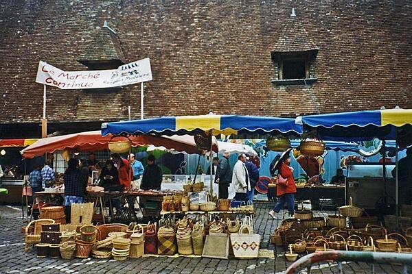
A street market in Beaune, a town located in the heart of the Burgundy wine region.
A street market in Beaune, a town located in the heart of the Burgundy wine region. • CIA World Factbook • 2020
Area comparison map
Area comparison map • CIA World Factbook • 2020
Area comparison map
Area comparison map • CIA World Factbook • 2020
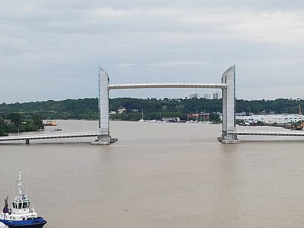
The 110 m-long Chaban-Delmas Bridge over the River Garonne in Bordeaux was opened in 2013. The center span can be raised to 77 m allowing tall ships to pass through. The bridge is named in honor of Jacques Chaban-Delmas, a former French prime minister and a former mayor of Bordeaux.
The 110 m-long Chaban-Delmas Bridge over the River Garonne in Bordeaux was opened in 2013. The center span can be raised to 77 m allowing tall ships to pass through. The bridge is named in honor of Jacques Chaban-Delmas, a former French prime minister and a former mayor of Bordeaux. • CIA World Factbook • 2020
Europe-US area comparison map
Europe-US area comparison map • CIA World Factbook • 2020
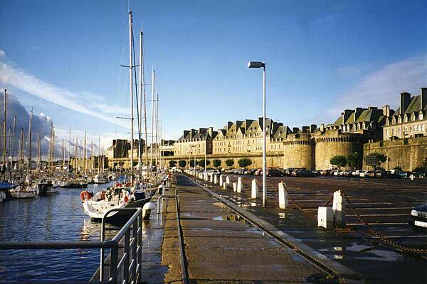
View of the marina outside the walled city of Saint-Malo in Brittany. The city began as a 6th century monastic settlement. Over time its citizens developed a reputation for asserting their autonomy. From 1490-93, Saint-Malo declared itself an independent republic. During the 16th-18th centuries, it was famous as the home of the corsairs (French privateers). Jacques Cartier, the French explorer, called Saint-Malo home. The first colonists of the Falkland Islands came from Saint-Malo.
View of the marina outside the walled city of Saint-Malo in Brittany. The city began as a 6th century monastic settlement. Over time its citizens developed a reputation for asserting their autonomy. From 1490-93, Saint-Malo declared itself an independent republic. During the 16th-18th centuries, it was famous as the home of the corsairs (French privateers). Jacques Cartier, the French explorer, called Saint-Malo home. The first colonists of the Falkland Islands came from Saint-Malo. • CIA World Factbook • 2020
Area comparison map
Area comparison map • CIA World Factbook • 2020
Area comparison map
Area comparison map • CIA World Factbook • 2020
Area comparison map
Area comparison map • CIA World Factbook • 2020
Area comparison map
Area comparison map • CIA World Factbook • 2020
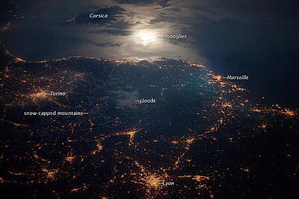
The brightly lit metropolitan areas of Torino (Italy), Lyon, and Marseille (both in France) stand out amidst numerous smaller urban areas in this dramatic photo from the international space station. The image captures the nighttime appearance of the France-Italy border. The southwestern end of the Alps Mountains separates the two countries. The island of Corsica is visible in the Ligurian Sea to the south (image top). The full moon reflects brightly on the water surface and also illuminates the tops of low patchy clouds over the border (center). Photo courtesy of NASA.
The brightly lit metropolitan areas of Torino (Italy), Lyon, and Marseille (both in France) stand out amidst numerous smaller urban areas in this dramatic photo from the international space station. The image captures the nighttime appearance of the France-Italy border. The southwestern end of the Alps Mountains separates the two countries. The island of Corsica is visible in the Ligurian Sea to the south (image top). The full moon reflects brightly on the water surface and also illuminates the tops of low patchy clouds over the border (center). Photo courtesy of NASA. • CIA World Factbook • 2020
CIA World Factbook • 2020
The Palais des Ducs de Bourgogne (Palace of the Dukes of Burgundy) in Dijon.
The Palais des Ducs de Bourgogne (Palace of the Dukes of Burgundy) in Dijon. • CIA World Factbook • 2020
Area comparison map
Area comparison map • CIA World Factbook • 2020
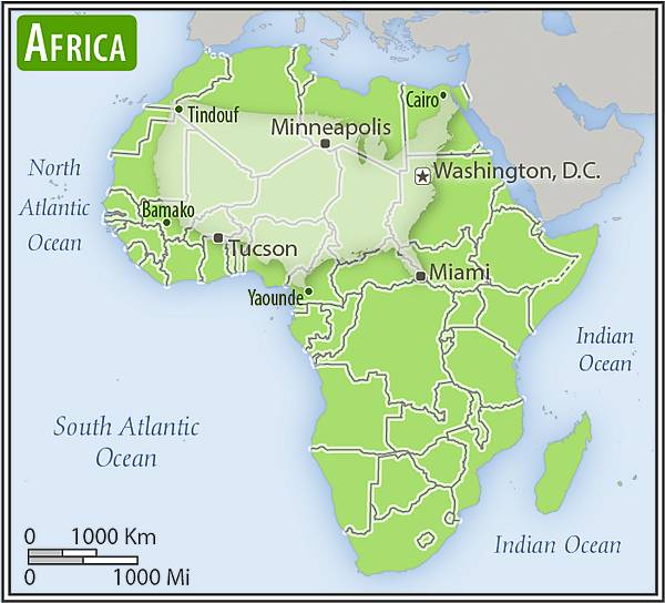
Africa-US area comparison map
Africa-US area comparison map • CIA World Factbook • 2020
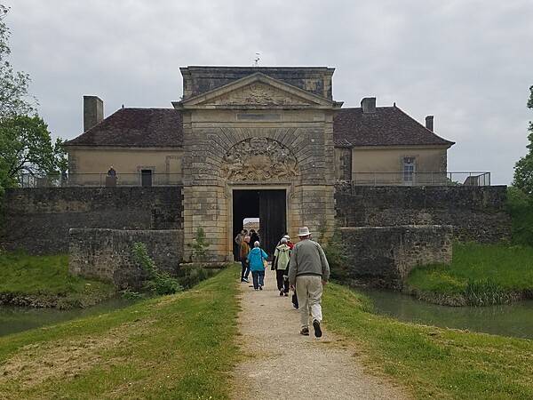
Fort Medoc was built between 1689 and 1721 on the orders of King Louis XIV to protect the seaward approaches to Bordeaux on the Gironde estuary.
Fort Medoc was built between 1689 and 1721 on the orders of King Louis XIV to protect the seaward
approaches to Bordeaux on the Gironde estuary. • CIA World Factbook • 2020
Area comparison map
Area comparison map • CIA World Factbook • 2020

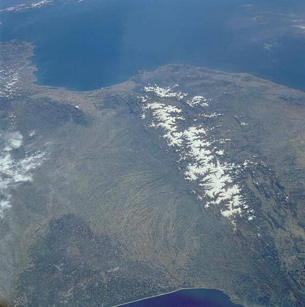
View of the Pyrenees Mountains between France and Spain taken April 1985. The snow-covered mountains, which form a formidable physical barrier between France to the north (left) and Spain to the south (right), are the main focus of this low-oblique, southeast-looking photograph. Scarcely interrupted by accessible passes and pierced in only two places by railroad tunnels, the Pyrenees are an ideal natural boundary between the Iberian Peninsula and the rest of Europe. The northern flank of the Pyrenees is characterized by a series of large alluvial deposits that fan out across southwestern France. The darker, roughly triangular area in southwest France is part of the forested Aquitaine Basin. The southern flank of the Pyrenees (Spain) is characterized by aridity and very rugged, mountainous conditions. Human settlement is sparse throughout the Pyrenees. However, because the region is rich in mineral waters, there are dozens of mineral water resorts, and winter sports attract visitors from southwestern France. The very small mountainous country of Andorra (not distinguishable in this photograph) has survived in an inaccessible upper valley of the Pyrenees. Image courtesy of NASA.
View of the Pyrenees Mountains between France and Spain taken April 1985. The snow-covered mountains, which form a formidable physical barrier between France to the north (left) and Spain to the south (right), are the main focus of this low-oblique, southeast-looking photograph. Scarcely interrupted by accessible passes and pierced in only two places by railroad tunnels, the Pyrenees are an ideal natural boundary between the Iberian Peninsula and the rest of Europe. The northern flank of the Pyrenees is characterized by a series of large alluvial deposits that fan out across southwestern France. The darker, roughly triangular area in southwest France is part of the forested Aquitaine Basin. The southern flank of the Pyrenees (Spain) is characterized by aridity and very rugged, mountainous conditions. Human settlement is sparse throughout the Pyrenees. However, because the region is rich in mineral waters, there are dozens of mineral water resorts, and winter sports attract visitors from southwestern France. The very small mountainous country of Andorra (not distinguishable in this photograph) has survived in an inaccessible upper valley of the Pyrenees. Image courtesy of NASA. • CIA World Factbook • 2020
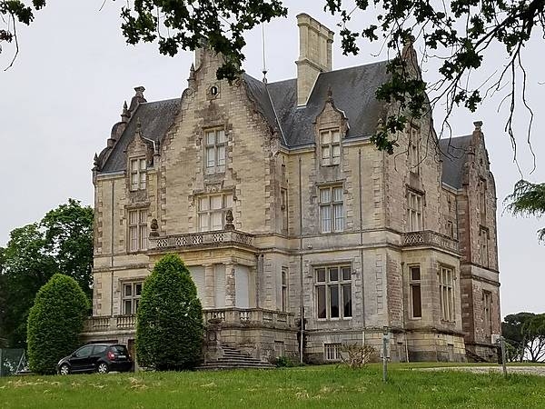
Chateau Lansessan in Cussac-Fort Medoc on the left bank of the Bordeaux wine region.
Chateau Lansessan in Cussac-Fort Medoc on the left bank of the Bordeaux wine region. • CIA World Factbook • 2020
CIA World Factbook • 2020

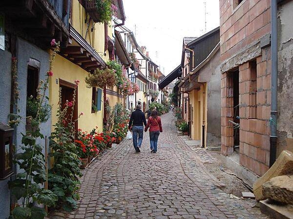
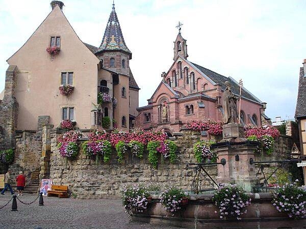
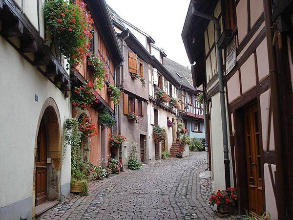
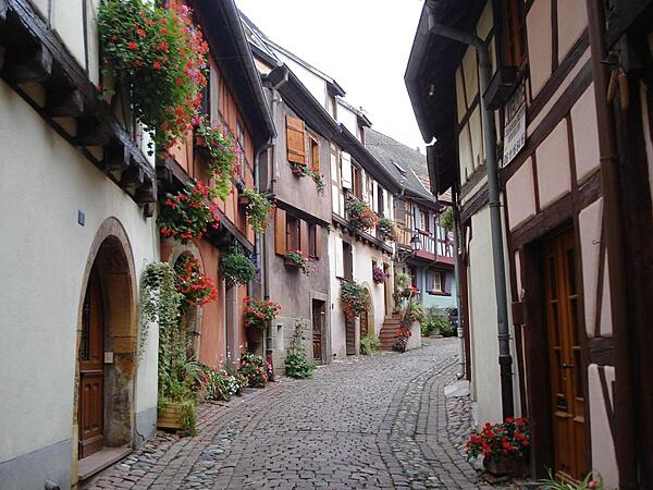
Strolling through the streets of Eguisheim.
Strolling through the streets of Eguisheim. • CIA World Factbook • 2020
Half timbered houses along a shopping street in old Colmar.
Half timbered houses along a shopping street in old Colmar. • CIA World Factbook • 2020
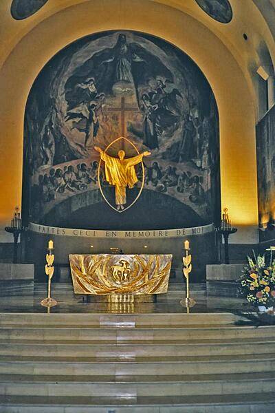
Altar in the church of Saint-Ferdinand-des-Ternes in Paris.
Altar in the church of Saint-Ferdinand-des-Ternes in Paris. • CIA World Factbook • 2020
Asia-US area comparison map
Asia-US area comparison map • CIA World Factbook • 2020
Chateau de Reignac in Saint Loubes near Bordeaux. The area is famous for its wine production.
Chateau de Reignac in Saint Loubes near Bordeaux. The area is famous for its wine production. • CIA World Factbook • 2020
The mansion of Clos Luce in Amboise is connected to the nearby royal Chateau by an underground passageway. It served as the residence of Leonardo da Vinci for the last three years of his life (1516-1519). The mansion currently is the museum for the surrounding region and displays 40 models of machines developed by Leonardo.
The mansion of Clos Luce in Amboise is connected to the nearby royal Chateau by an underground passageway. It served as the residence of Leonardo da Vinci for the last three years of his life (1516-1519). The mansion currently is the museum for the surrounding region and displays 40 models of machines developed by Leonardo. • CIA World Factbook • 2020
CIA World Factbook • 2020
CIA World Factbook • 2020
CIA World Factbook • 2020
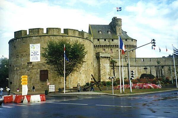
The Chateau de Saint-Malo in Britanny now serves as the town museum and town hall.
The Chateau de Saint-Malo in Britanny now serves as the town museum and town hall. • CIA World Factbook • 2020
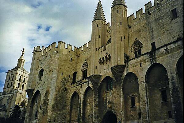
The city of Avignon in southeastern France is well known as the former seat of the papacy in the 14th century. Shown is the Palais des Papes (Palace of the Popes) on the right and the Romanesque Cathedral Notre Dames-des Doms on the far left.
The city of Avignon in southeastern France is well known as the former seat of the papacy in the 14th century. Shown is the Palais des Papes (Palace of the Popes) on the right and the Romanesque Cathedral Notre Dames-des Doms on the far left. • CIA World Factbook • 2020
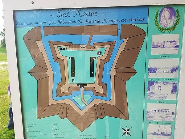
Built on marshy soil, Fort Medoc does not have tall walls. Its defenses reflect the military design principles of the 17th century, which included short, thick earthen walls impervious to cannon fire.
Built on marshy soil, Fort Medoc does not have tall walls. Its defenses reflect the military design principles of the 17th century, which included short, thick earthen walls impervious to cannon fire. • CIA World Factbook • 2020
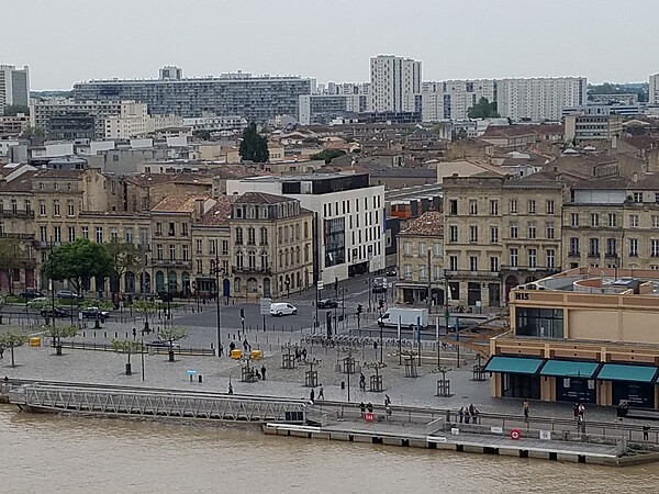
View of Bordeaux, the capital of the historic region of Aquitaine.
View of Bordeaux, the capital of the historic region of Aquitaine. • CIA World Factbook • 2020
CIA World Factbook • 2020
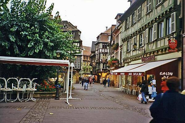
Street scene in the Alsatian town of Colmar.
Street scene in the Alsatian town of Colmar. • CIA World Factbook • 2020
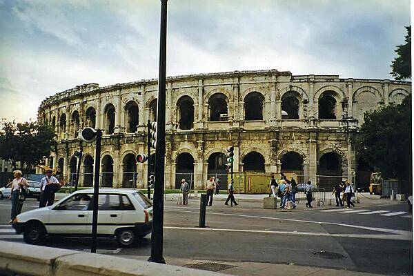
The ancient Roman arena at Nimes is still in use today. Built about A.D. 70, it was remodeled in 1863 and can seat some 16,300 spectators.
The ancient Roman arena at Nimes is still in use today. Built about A.D. 70, it was remodeled in 1863 and can seat some 16,300 spectators. • CIA World Factbook • 2020
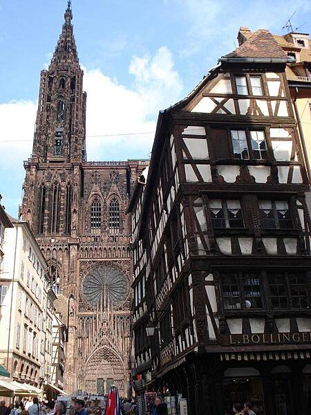
Strasbourg Cathedral was begun in 1176 and completed in 1439. Although it displays some elements of Romanesque style, it is widely considered to be among the finest examples of high Gothic architecture. Inside is an unusually accurate clock that has been built and rebuilt three times over the centuries, and which indicates a variety of astronomical data. The animated figures still move to indicate the hours of the day.
Strasbourg Cathedral was begun in 1176 and completed in 1439. Although it displays some elements of Romanesque style, it is widely considered to be among the finest examples of high Gothic architecture. Inside is an unusually accurate clock that has been built and rebuilt three times over the centuries, and which indicates a variety of astronomical data. The animated figures still move to indicate the hours of the day. • CIA World Factbook • 2020
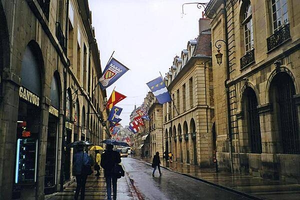
A street scene in Dijon, the capital of the Burgundy region. The city was first settled by the Romans and then became the domain of the Dukes of Burgundy, who ruled the area until the late 1400s. It is known for its many architectural styles and hosts the annual Dijon International and Gastronomic Fair.
A street scene in Dijon, the capital of the Burgundy region. The city was first settled by the Romans and then became the domain of the Dukes of Burgundy, who ruled the area until the late 1400s. It is known for its many architectural styles and hosts the annual Dijon International and Gastronomic Fair. • CIA World Factbook • 2020
CIA World Factbook • 2020
CIA World Factbook • 2020
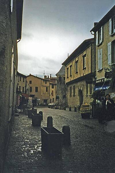
A street scene on a rainy day in the fortified town of Carcassone.
A street scene on a rainy day in the fortified town of Carcassone. • CIA World Factbook • 2020
CIA World Factbook • 2020
CIA World Factbook • 2020
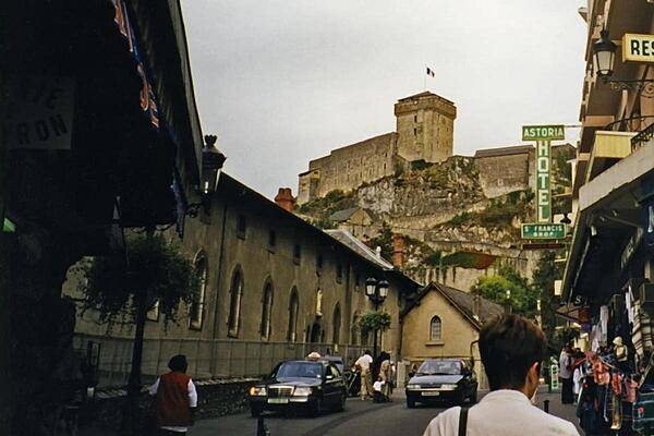
The Chateau fort de Lourdes, which overlooks the town, occupies a strategic position in the Pyrenees. Parts of the structure date back to Roman times.
The Chateau fort de Lourdes, which overlooks the town, occupies a strategic position in the Pyrenees. Parts of the structure date back to Roman times. • CIA World Factbook • 2020
CIA World Factbook • 2020
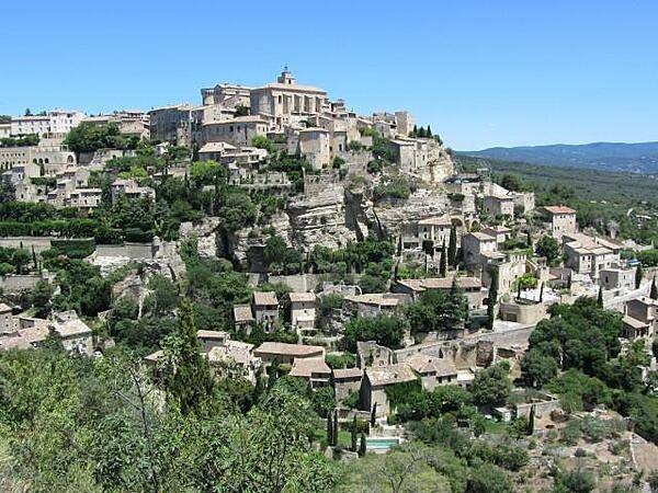
The village square in Gordes is adjacent to the Castle.
The village square in Gordes is adjacent to the Castle. • CIA World Factbook • 2020
The main square in Equisheim with the Church of Saint Peter and Saint Paul. This church, built in 1808, replaced one dating to medieval times.
The main square in Equisheim with the Church of Saint Peter and Saint Paul. This church, built in 1808, replaced one dating to medieval times. • CIA World Factbook • 2020

CIA World Factbook • 2020
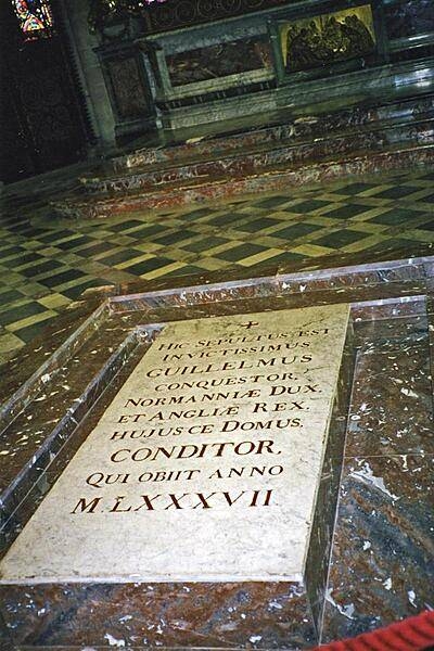
The tomb of William the Conqueror in the Church of St. Etienne in Caen.
The tomb of William the Conqueror in the Church of St. Etienne in Caen. • CIA World Factbook • 2020
Area comparison map
Area comparison map • CIA World Factbook • 2020
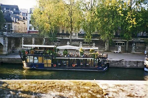
Flower festooned boat on the Seine River in Paris.
Flower festooned boat on the Seine River in Paris. • CIA World Factbook • 2020

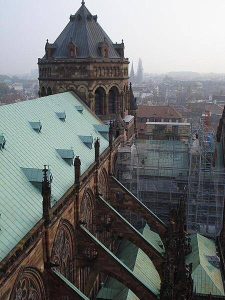
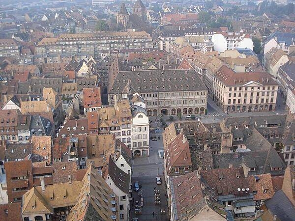
View of the Strasbourg Cathedral roof from its spire. Some of the flying buttresses supporting the cathedral walls can be clearly seen.
View of the Strasbourg Cathedral roof from its spire. Some of the flying buttresses supporting the cathedral walls can be clearly seen. • CIA World Factbook • 2020
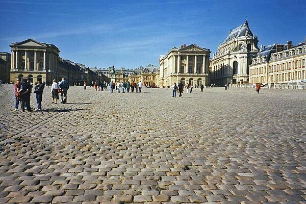
The massive courtyard at the Chateau de Versailles (Palace of Versailles). Most of the construction at the sprawling site was carried out in four phases between 1664 and 1710, during the reign of Louis XIV.
The massive courtyard at the Chateau de Versailles (Palace of Versailles). Most of the construction at the sprawling site was carried out in four phases between 1664 and 1710, during the reign of Louis XIV. • CIA World Factbook • 2020
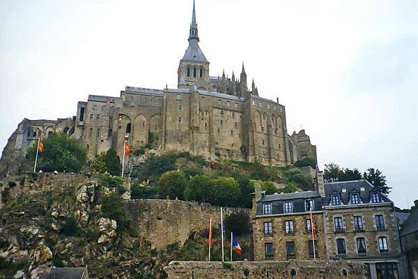
The fortified island abbey of Mont-Saint-Michel off the coast of Normandy. At one time the site was disconnected from the coast at high tide, but silting has since connected the island to the mainland. Today, an operation is underway to desilt the area around the island. It was not until the 8th century that the first monastic establishment appeared on the island. Before that it was a stronghold of Romano-Breton culture and power. In the Hundred Years War, the French successfully prevented the English from capturing the island. During the Reformation, the popularity of the Mont declined, and during the French Revolution it became a prison which finally closed in 1863. In 1874, Mont-Saint-Michel was declared a historic monument; in 1979, it became a UNESCO World Heritage Site.
The fortified island abbey of Mont-Saint-Michel off the coast of Normandy. At one time the site was disconnected from the coast at high tide, but silting has since connected the island to the mainland. Today, an operation is underway to desilt the area around the island. It was not until the 8th century that the first monastic establishment appeared on the island. Before that it was a stronghold of Romano-Breton culture and power. In the Hundred Years War, the French successfully prevented the English from capturing the island. During the Reformation, the popularity of the Mont declined, and during the French Revolution it became a prison which finally closed in 1863. In 1874, Mont-Saint-Michel was declared a historic monument; in 1979, it became a UNESCO World Heritage Site. • CIA World Factbook • 2020
CIA World Factbook • 2020

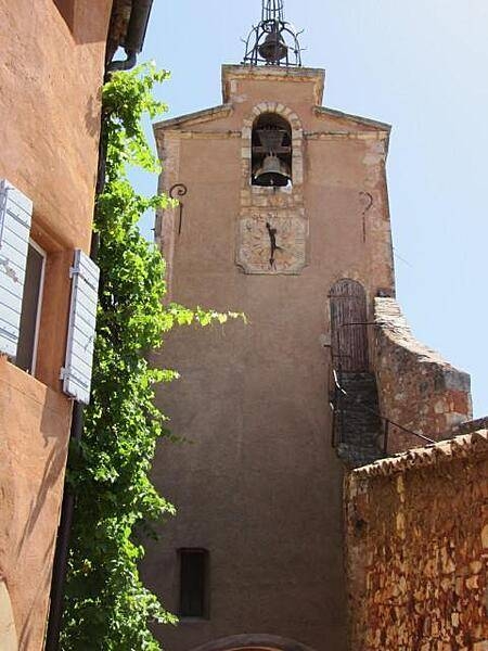
Village church in Roussillon, Provence.
Village church in Roussillon, Provence. • CIA World Factbook • 2020
A cafe on a canal in Colmar. The town, situated on the Alsatian Wine Route, was founded in the 9th century. In 1226, it became a Free Imperial City of the Holy Roman Empire. It was conquered by Louis XIV and the French in 1673 and over subsequent centuries alternated between German and French control. It reverted to France in 1945.
A cafe on a canal in Colmar. The town, situated on the Alsatian Wine Route, was founded in the 9th century. In 1226, it became a Free Imperial City of the Holy Roman Empire. It was conquered by Louis XIV and the French in 1673 and over subsequent centuries alternated between German and French control. It reverted to France in 1945. • CIA World Factbook • 2020
View of the Pyrenees Mountains between France and Spain taken April 1985. The snow-covered mountains, which form a formidable physical barrier between France to the north (left) and Spain to the south (right), are the main focus of this low-oblique, southeast-looking photograph. Scarcely interrupted by accessible passes and pierced in only two places by railroad tunnels, the Pyrenees are an ideal natural boundary between the Iberian Peninsula and the rest of Europe. The northern flank of the Pyrenees is characterized by a series of large alluvial deposits that fan out across southwestern France. The darker, roughly triangular area in southwest France is part of the forested Aquitaine Basin. The southern flank of the Pyrenees (Spain) is characterized by aridity and very rugged, mountainous conditions. Human settlement is sparse throughout the Pyrenees. However, because the region is rich in mineral waters, there are dozens of mineral water resorts, and winter sports attract visitors from southwestern France. The very small mountainous country of Andorra (not distinguishable in this photograph) has survived in an inaccessible upper valley of the Pyrenees. Image courtesy of NASA.
View of the Pyrenees Mountains between France and Spain taken April 1985. The snow-covered mountains, which form a formidable physical barrier between France to the north (left) and Spain to the south (right), are the main focus of this low-oblique, southeast-looking photograph. Scarcely interrupted by accessible passes and pierced in only two places by railroad tunnels, the Pyrenees are an ideal natural boundary between the Iberian Peninsula and the rest of Europe. The northern flank of the Pyrenees is characterized by a series of large alluvial deposits that fan out across southwestern France. The darker, roughly triangular area in southwest France is part of the forested Aquitaine Basin. The southern flank of the Pyrenees (Spain) is characterized by aridity and very rugged, mountainous conditions. Human settlement is sparse throughout the Pyrenees. However, because the region is rich in mineral waters, there are dozens of mineral water resorts, and winter sports attract visitors from southwestern France. The very small mountainous country of Andorra (not distinguishable in this photograph) has survived in an inaccessible upper valley of the Pyrenees. Image courtesy of NASA. • CIA World Factbook • 2020
CIA World Factbook • 2020
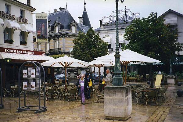
Shops in the town of Cognac, where the famous brandy (distilled wine) was first developed.
Shops in the town of Cognac, where the famous brandy (distilled wine) was first developed. • CIA World Factbook • 2020
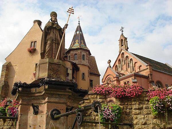
The Chapel of Saint-Leo IX stands in the main square of Eguisheim next to the Church of Saint Peter and Saint Paul.
The Chapel of Saint-Leo IX stands in the main square of Eguisheim next to the Church of Saint Peter and Saint Paul. • CIA World Factbook • 2020
CIA World Factbook • 2020
The Eglise Saint-Matthieu (Dominican Church of St. Matthew) in the Alsatian town of Colmar was built in the 13th century.
The Eglise Saint-Matthieu (Dominican Church of St. Matthew) in the Alsatian town of Colmar was built in the 13th century. • CIA World Factbook • 2020
CIA World Factbook • 2020
CIA World Factbook • 2020
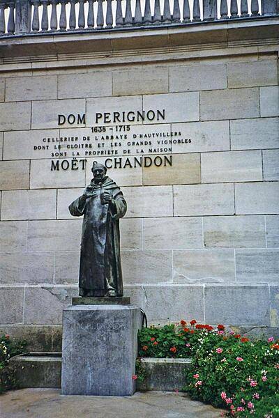
Statue of Dom Perignon (1638-1715) in the town of Epernay. The Benedictine monk made many important contributions to the production and quality of champagne wines.
Statue of Dom Perignon (1638-1715) in the town of Epernay. The Benedictine monk made many important contributions to the production and quality of champagne wines. • CIA World Factbook • 2020
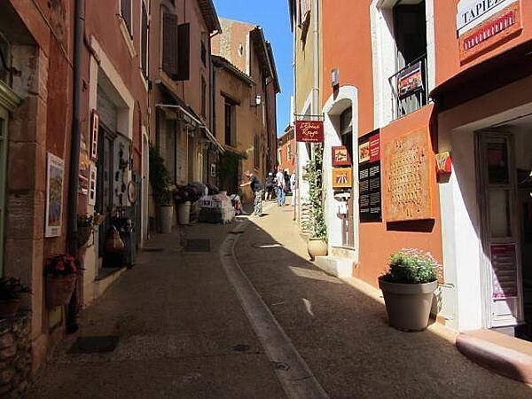
Farmers market in Nice.
Farmers market in Nice. • CIA World Factbook • 2020

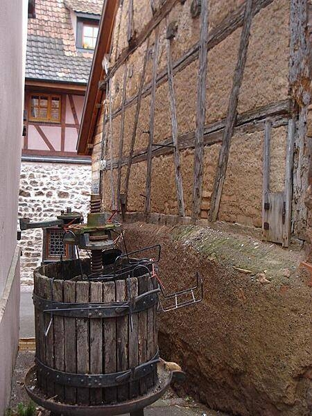
Old wine press along the streets of Eguisheim.
Old wine press along the streets of Eguisheim. • CIA World Factbook • 2020

CIA World Factbook • 2020
CIA World Factbook • 2020
A section of the fortifications at Chateau Comtal, part of the larger defenses at the fortress of Carcassone.
A section of the fortifications at Chateau Comtal, part of the larger defenses at the fortress of Carcassone. • CIA World Factbook • 2020
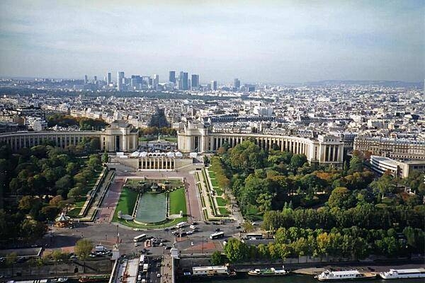
View of the Palais de Chaillot as seen from the Eiffel Tower in Paris. The two curved buildings making up the site house a number of museums.
View of the Palais de Chaillot as seen from the Eiffel Tower in Paris. The two curved buildings making up the site house a number of museums. • CIA World Factbook • 2020
Street scene along the flower-lined streets of Eguisheim.
Street scene along the flower-lined streets of Eguisheim. • CIA World Factbook • 2020
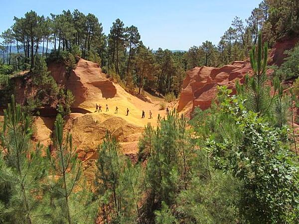
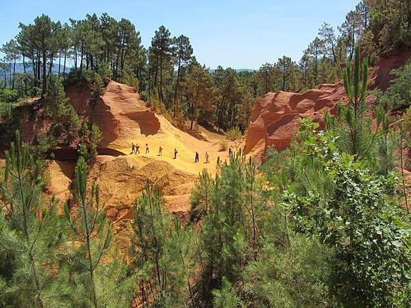
Much of the architecture in Roussillon is colored with earthen tones from a nearby ocher quarry.
Much of the architecture in Roussillon is colored with earthen tones from a nearby ocher quarry. • CIA World Factbook • 2020
CIA World Factbook • 2020
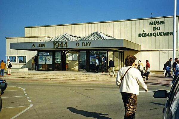
Entrance to the D-Day Landing Museum in Arromanches, Normandy.
Entrance to the D-Day Landing Museum in Arromanches, Normandy. • CIA World Factbook • 2020
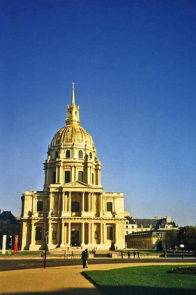
The Eglise du Dome is the church at the building complex named Les Invalides in Paris. Containing a hospital and retirement home for war veterans, the site also consists of museums and monuments relating to the military history of France.
The Eglise du Dome is the church at the building complex named Les Invalides in Paris. Containing a hospital and retirement home for war veterans, the site also consists of museums and monuments relating to the military history of France. • CIA World Factbook • 2020
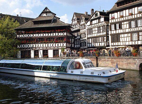
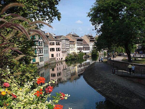
A sightseeing boat along the Ill River in Strasbourg.
A sightseeing boat along the Ill River in Strasbourg. • CIA World Factbook • 2020
CIA World Factbook • 2020
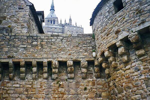
Close up of some of the impressive fortifications at Mont-Saint-Michel.
Close up of some of the impressive fortifications at Mont-Saint-Michel. • CIA World Factbook • 2020
CIA World Factbook • 2020
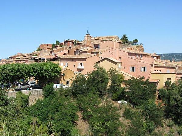
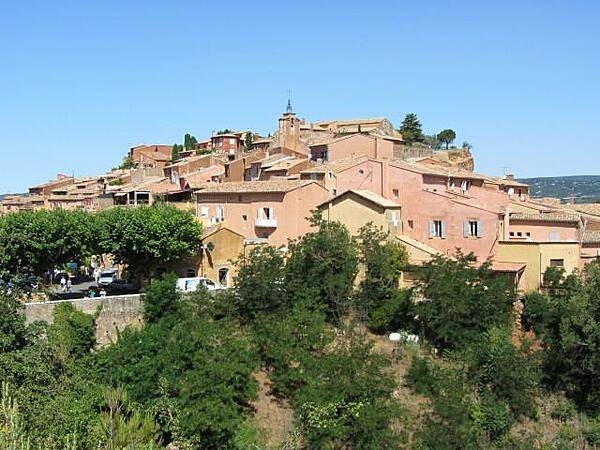
View of the village of Roussillon in Provence. The village sits atop the highest hills between the Coulon Valley and the Vaucluse Plateau.
View of the village of Roussillon in Provence. The village sits atop the highest hills between the Coulon Valley and the Vaucluse Plateau. • CIA World Factbook • 2020
CIA World Factbook • 2020
CIA World Factbook • 2020
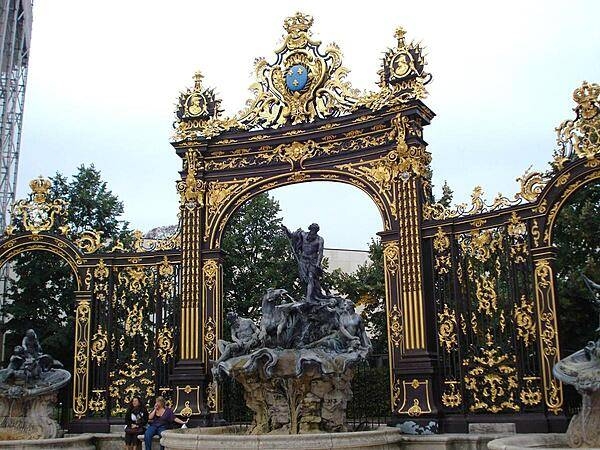
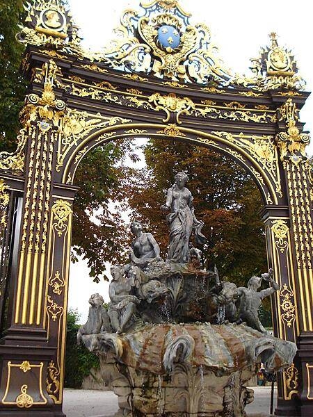
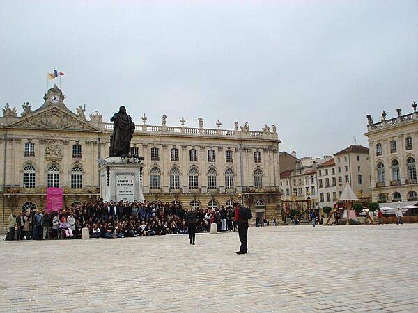
The Neptune Fountain is one of four waterworks erected by Barthelemy Guibal in Stanislas Square in Nancy; this one was completed in 1751.
The Neptune Fountain is one of four waterworks erected by Barthelemy Guibal in Stanislas Square in Nancy; this one was completed in 1751. • CIA World Factbook • 2020
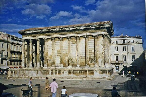
The Maison Carree in Nimes, one of the best preserved of surviving Roman temples, dates to 16 B.C. In subsequent centuries it served as a church, a meeting hall, a storehouse, and a stable. In 1823 it became a museum.
The Maison Carree in Nimes, one of the best preserved of surviving Roman temples, dates to 16 B.C. In subsequent centuries it served as a church, a meeting hall, a storehouse, and a stable. In 1823 it became a museum. • CIA World Factbook • 2020

View of an alley in the village of Roussillon in Provence.
View of an alley in the village of Roussillon in Provence. • CIA World Factbook • 2020
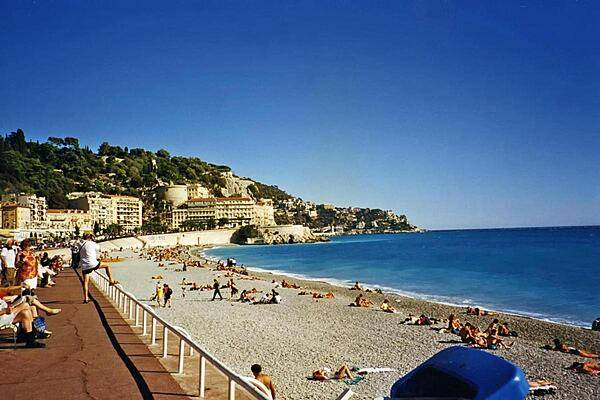
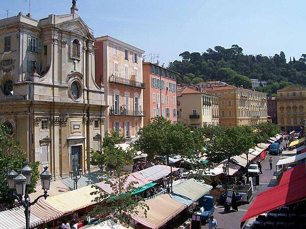
A beach at Nice. The city is a major tourist center and a leading resort along the French Riviera.
A beach at Nice. The city is a major tourist center and a leading resort along the French Riviera. • CIA World Factbook • 2020
CIA World Factbook • 2020

CIA World Factbook • 2020
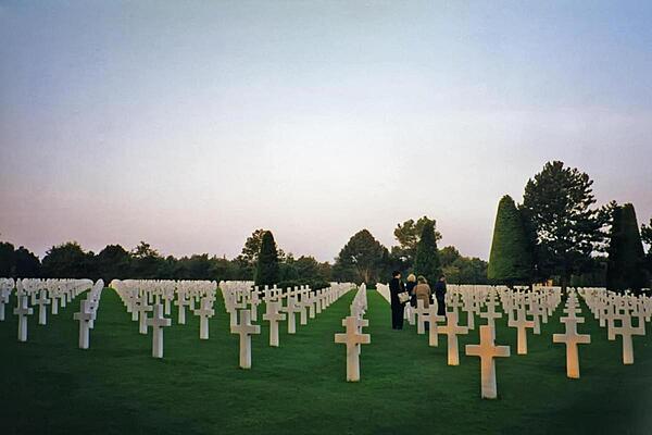
Rows of crosses at the American Cemetery in Colleville-sur-Mer, Normandy. Located on a bluff overlooking Omaha Beach (one of the landing beaches for the Normandy Invasion of 1944), the cemetery contains the remains of 9,387 American military dead.
Rows of crosses at the American Cemetery in Colleville-sur-Mer, Normandy. Located on a bluff overlooking Omaha Beach (one of the landing beaches for the Normandy Invasion of 1944), the cemetery contains the remains of 9,387 American military dead. • CIA World Factbook • 2020
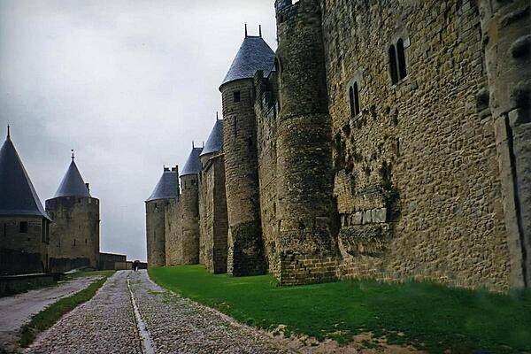
Some of the massive walls at the fortified town of Carcassone. Restored in 1853, the fortress became a UNESCO World Heritage Site in 1997.
Some of the massive walls at the fortified town of Carcassone. Restored in 1853, the fortress became a UNESCO World Heritage Site in 1997. • CIA World Factbook • 2020

The Castle on the village square in Gordes, Provence, was partially rebuilt in 1525.
The Castle on the village square in Gordes, Provence, was partially rebuilt in 1525. • CIA World Factbook • 2020
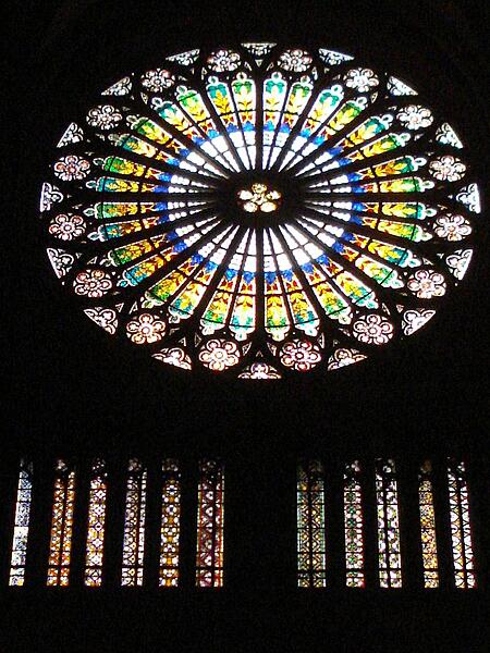
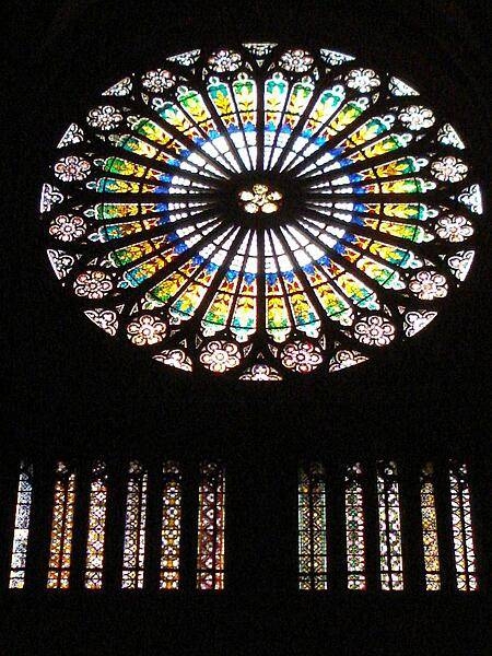
Rose windows, such as this one in Strasbourg Cathedral, are a common feature of Gothic architecture.
Rose windows, such as this one in Strasbourg Cathedral, are a common feature of Gothic architecture. • CIA World Factbook • 2020
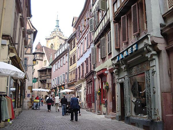
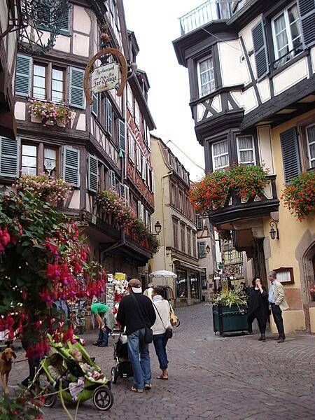
A street scene in old Colmar. The picturesque town is a tourist magnet; it annually hosts the Alsatian Wine Fair.
A street scene in old Colmar. The picturesque town is a tourist magnet; it annually hosts the Alsatian Wine Fair. • CIA World Factbook • 2020
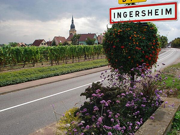
The road into Ingersheim on the Alsatian Wine Route.
The road into Ingersheim on the Alsatian Wine Route. • CIA World Factbook • 2020
Street scene in Eguisheim along the Alsace Wine Trail.
Street scene in Eguisheim along the Alsace Wine Trail. • CIA World Factbook • 2020
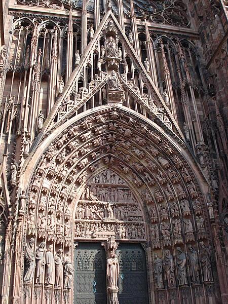
The famous west portal of the Strasbourg Cathedral is in the Gothic style and has hundreds of figures sculpted into it.
The famous west portal of the Strasbourg Cathedral is in the Gothic style and has hundreds of figures sculpted into it. • CIA World Factbook • 2020
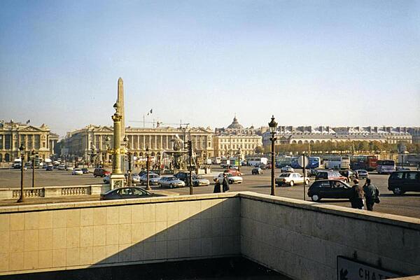
The Place de la Concorde in Paris is the largest square in the French capital. In the center of the Place stands a giant obelisk, transported from Egypt and erected in 1836.
The Place de la Concorde in Paris is the largest square in the French capital. In the center of the Place stands a giant obelisk, transported from Egypt and erected in 1836. • CIA World Factbook • 2020
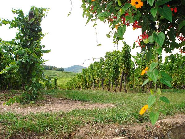
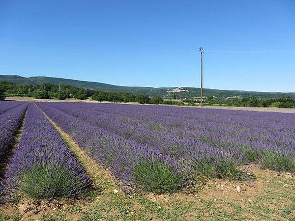
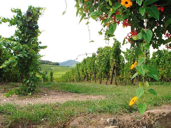
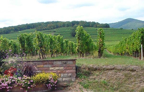
Vineyards along the Alsatian Wine Route.
Vineyards along the Alsatian Wine Route. • CIA World Factbook • 2020
Media source: CIA World Factbook (2020) — Public Domain